Mudflat hike

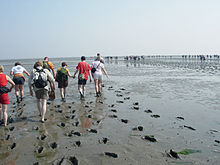
Under tideland means a hike in watts . To or between some of the islands there are mudflat hiking trails , some of which are also marked with bush pricks and which offer protection with rescue beacons if hikers are surprised by the tide.
Special features of mudflat hiking
The mudflats - the ocean floor that is only exposed at low tide - consists of sand and silt . This is a sandy-clayey-calcareous alluvial surface of the sea with organic admixtures. A distinction is made between sand mud flats, mixed mud flats and silt mud flats. The most suitable soil for a hike are the sand mud flats and the mixed mud flats. You don't sink too deeply here. Walking is therefore easier. Sand flats can be very hard, but mud flats are muddy . You can sink in to your knees, but in rare cases also to your hips.
Depending on the type of mudflat, people usually go barefoot in the sand mudflats and barefoot in the mud flats or with closed shoes because of the mussels that live there. In Sandwatt, walking without shoes is considered more comfortable, the feet receive a natural massage . Hiking in this wide landscape and the clean air is considered very relaxing and should promote stress relief .
A mudflat hike far away from the coast should only be undertaken by those who are not familiar with the mudflat guide, as at high tide the tidal creeks are flooded first and the way back can be cut off. Mudflat guides are informed about the daily changing tides and the changing course of the creeks and plan the hike accordingly. Another danger is sea fog , which can appear suddenly and make orientation difficult or even impossible. Due to the reflection of the sunlight from the wet ground, the solar radiation is very intense in the watt, which can lead to sunburn and mild burns of the retina . Mussels can injure the feet, cold and water in the mud flats can lead to hypothermia .
As part of an organized mudflat tour, you can get information about the natural area of the Wadden Sea, the creatures in the tidal flats and the effect of the tides on the Wadden Sea. Most tourist offices and nature conservation associations, such as the Wadden Sea Conservation Station, offer guided mudflat walks .
The Wadden Sea is under nature protection . This means that there are rules that prohibit entering certain areas, for example.
Well-known mudflat hiking trails

- Between the North Frisian islands of Amrum and Föhr there is an eight kilometer long Wadden Trail. As part of a guided hike, when the tide is low , you can walk from one island to the other after crossing two knee-deep to hip-deep tides of the Amrumtief shortly before Amrum.
- Guided hikes are regularly offered to some Halligen in the North Frisian Wadden Sea, such as between Dagebüll on the mainland and Hallig Oland (distance six kilometers) and Hallig Langeneß (distance ten kilometers), as well as between Schlüttsiel and Hallig Gröde (distance eight kilometers) and from Lüttmoorsiel to Nordstrandischmoor (distance 4.5 kilometers). Depending on the tide, a subsequent boat tour is possible at high tide. Hikes to the Hallig Südfall are also carried out from Nordstrand .
- From the Cuxhaven districts of Duhnen and Sahlenburg, two mudflat trails that unite on the way to the island of Neuwerk . You can only walk one way at a time in a tide. Horse-drawn carriages are also used from Sahlenburg and Duhnen for the eight and twelve kilometer tour. From Neuwerk you can return to Cuxhaven by ship at high tide.
- From Neuwerk, a mudflat hiking trail leads past Nigehorn to Scharhörn , which has to be walked back every now and then when the water is low. The island of Scharhörn may not be entered, except for official tours or after having notified the responsible bird warden in advance.
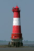
- The Arngast lighthouse in the Jade Bay- Watt can be reached on foot at low tide.
- Regular hikes through the mudflats are offered to the East Frisian islands of Norderney , Baltrum , Spiekeroog and Minsener Oog . Mudflat hikes to the island of Langeoog are very seldom due to the increased difficulty. There is no mudflat hiking connection to the westernmost island of Borkum . Hikes to the islands of Wangerooge and Juist are not allowed.
- In the Netherlands , the West Frisian Islands Terschelling , Ameland , Engelsmanplaat , Schiermonnikoog , Simonszand and Rottumeroog are within walking distance.
- From Genêts in Normandy past the uninhabited rocky island of Tombelaine to Mont-Saint-Michel (seven kilometers), guided hikes are offered. They take place from late April to October. There is quicksand in this area .
