
Wadden Sea (North Sea)


The Wadden Sea of the North Sea is in an area where the tide lying about 9000 km², 450 km long and up to 40 km wide landscape between Skallingen , Denmark , in the northeast and Den Helder , Netherlands , in the southwest. The bottom of the North Sea exposed at low tide is known as the tidal flats . It is the largest Wadden Sea in the world.
The tidal flats are flooded twice a day during high tide and fall dry again at low tide , with the water often flowing away through deep streams ( tidal creeks ). The time interval between high tide and low tide averages six hours and twelve minutes. The Wadden Sea, formed about 7,500 years ago, has one of the highest primary production rates in the world. It therefore serves as a resting place and source of food for many birds and fish.
Almost the entire Wadden Sea is under nature protection . The German part is protected as a national park - apart from the large estuaries, which are important as shipping routes, and the mudflat areas of the state of Bremen . The Danish part followed in 2009, the Dutch part is subject to a complex network of various protective measures. The Schleswig-Holstein , Lower Saxony and Dutch Wadden Sea area belongs since 2009 to the UNESCO World Natural Heritage , 2011, which was Hamburg Wadden Sea , 2014 the Danish National Park Vadehavet added to the list.
The Wadden Sea coast of the North Sea was included in the list of 77 awarded National Geotopes in 2006.
geography


The Wadden Sea is located in the southeastern part of the North Sea in the German Bight . It stretches along the entire coast from Den Helder in the Netherlands over the North Sea coast of Lower Saxony, Bremen and Schleswig-Holstein to Blåvand in Denmark. Around 30% of the area is under Dutch, 60% under German and around ten percent under Danish jurisdiction.
In the southern part of Den Helder over the Ems to the mouth of the Weser , the Wadden Sea lies behind barrier islands that have arisen from sandbanks ( East Frisian Islands and West Frisian Islands ). The width of the Wadden Sea ranges from six kilometers between the East Frisian Islands and the mainland to 40 or 50 kilometers in large bays such as the Jade Bay , the Dollart or the Leybucht . In some cases, large bays in the Netherlands were completely diked and thus withdrawn from the direct influence of the sea; the most famous and largest example of this is the IJsselmeer .
The Wadden Sea consists of three zones: the sublittoral zone is permanently under water, here you will find the large tidal currents and sea marshes that connect the Wadden Sea with the open sea, and shallower areas around these tidal currents. The eulittal zone is the actual mudflats . It is above the water level at low tide, but below it at high tide and falls dry twice a day. There are mussel beds and lugworms live here . The supralitoral zone lies above the mean high tide (MThw), but is still flooded during spring tides or storm surges . Here you will find salt marshes with their special flora and fauna.
The central Wadden Sea extends from the Weser over the Elbe to the mouth of the Eider and to Eiderstedt , where the Wadden Sea, North Sea and the estuaries merge directly into one another. Here, the tides mainly form sandbanks, which, however, could hardly develop into islands. Some smaller islands and sandbanks such as the Große Knechtsand , Mellum , Neuwerk or Trischen form a patchy, badly broken barrier, in the shadow of which the wadden areas developed.
The northern Wadden Sea is north of Eiderstedt all the way to Blåvand. Here the Wadden Sea is protected by the North Frisian Geestkern and marshland islands , which were originally part of the mainland and became islands due to storm surges .
Southern Wadden Sea
To the north-west (seaward) of Texel and Borkum are rocky reefs that have withstood the erosion force of the sea. Sandbanks could form in the shadows of the current, from which the West and East Frisian Islands emerged over time. These sandbanks and the later islands protected the broad fringing between these and the mainland from the surf, and sediments were not washed away again.
The ocean currents formed sandbanks which piled up to form barrier islands in the southern Wadden Sea ( East Frisian and West Frisian Islands ). This process runs continuously. In the last few centuries, for example, Bant and Buise disappeared into the sea, which is why Memmert and the Kachelotplate were created . Other sandbanks like Lütje Hörn cannot seem to establish themselves permanently.
These islands and sandbanks protected the coast beyond. Deposits from the rivers and the sea that accumulated on the very flat coastal profile created silt and sand mud flats. These sandbanks are larger and longer, the less pronounced the difference between high and low water. The westernmost islands, which are closest to the North Sea amphidromy on the English Channel, are the largest, while only comparatively small sandbanks form in the tidal funnel of the central German bay.
Central Wadden Sea
While the shape of the North Frisian Wadden Sea was largely shaped by numerous Ice Age deposits, the melting glaciers further south caused the erosion of sediments. The meltwater, which flowed through the later estuaries of the Eider , Elbe and Weser , carried away the coastal deposits . The glacial layer in this area of the Wadden Sea is ten meters below sea level than further north. The creeks are deeper, more numerous and often more powerful. At times the coast reached right up to the closed Geestrand . The sediments that were then deposited here are much younger than in the north, the sediment layer is thicker. Since far fewer bogs and swamps formed than in the northern Wadden Sea, the country is more stable, once won land is - in contrast to North Friesland - hardly lost to the sea.
High sand and sandbanks that form here are highly dynamic and shift several meters a year eastwards towards the coast. Attempts to fix them in Trischen , as in the 1930s, failed. In the meantime, the systems, which were originally built on the east side of the land, are reappearing on the western, seaward tidal flats. Sandbanks like Tötel or Tertius can disappear completely here if the sediment input subsides or if they had to cross a deep creek on their way to the coast. On the other hand, observations of the last twenty years suggest that further seaward, new high sands regularly form, which then start their journey to the coast.
Northern Wadden Sea
Geest walls formed in the North Frisian part of the Wadden Sea. Numerous glacier deposits from the area west of North Friesland were washed up on the coast, where they formed spits that connected the geest cores to form a solid coastline. They protected the deeper areas behind. Wetlands, bogs and swamps formed there, in which peat was formed, as well as the sediments that came from the higher landside geest areas. Due to ingress of water, especially during storm surges , the lower-lying flat moors got under water at least temporarily and today form the extensive northern tidal flats. Remnants of the former Geestwall form the North Frisian Islands . Approaches to barrier islands can also be found here, such as the Jordsand , but the offshore Geest core islands probably prevented their formation.
In the Danish part of the Wadden Sea, on the other hand, the Danish Wadden Sea Islands belong to the barrier islands that developed from sandbanks. Similar to other barrier islands, they are much shallower than the Geestinseln in North Friesland, but like these also have marsh deposits on their east (land) side that merge into the Wadden Sea. While the coasts of Sylt in the south of the area and of the Skallingen peninsula in the north recede by around one to two meters each year, these sediments end up in Fanø and Rømø , where dune walls are newly formed. They run through tidal currents such as Grådyb , Knudedyb , Juvre Dyb and Lister Tief , these are continuations of the Kongeå , Ribe Å and Wiedau rivers , making the Danish west coast easy to develop in an east-west direction, but very difficult to develop in a north-south direction is. The Ho Bugt is the only large Wadden Sea bay outside of the southern Wadden Sea.
climate

The Wadden Sea is in the temperate climate zone; important influencing factors are warm Atlantic water from the North Atlantic Current and westerly winds, the strength of which has increased considerably since the 1960s. Both wind strength and wind direction were subject to considerable variations over the years. The so-called disaster winter 1978/79 was characterized by very low wind speeds and hardly any Atlantic water flowing into the North Sea. Winter temperatures in particular seem to largely depend on how much Atlantic water gets into the North Sea, although these have increased significantly on average in recent years.
Fog layers are frequent and often long-lasting. Storms are just as common, but they are usually short and last less than four hours. Freezing of the sea can occur, but it is rare and only occurs every few years. The amount of precipitation increases from west to east, is 200 to 400 mm in the Dutch Wadden Sea, between 400 and 600 mm in the German and Danish Wadden Sea and 800 to 1000 mm in the Elbe estuary.
The global warming will have on the Wadden Sea considerable influence, namely by further sea level rise and changes in the Wadden Sea ecosystem, which influences as dynamic as sensitive to changing reacts from the outside. In recent years, species that were previously only to be found further south have been spreading, and the habits of long-established species have changed, sometimes considerably.
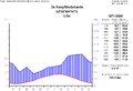
Climate diagram of De Kooy (Den Helder), Netherlands

Climate diagram of Norderney, Lower Saxony

Climate diagram of List, Sylt, Schleswig-Holstein

Climate diagram of Fanø, Denmark


-Deutschland-metrisch-deutsch.png)

geology

The Wadden Sea is a geologically very young landscape. It owes its formation to the ice ages . The North Sea coast originally consisted of sand and moraines , which the Ice Age glaciers formed from Scandinavian rocks. Today these form the natural area of the Geest . The glaciers of the Vistula Ice Age only covered parts of what was later to be the North Sea area, while the masses of water flowing off the glaciers partially leveled sand and moraines.
An important condition for the formation of the Wadden Sea is, on the one hand, a steady inflow of sediment from rivers and ocean currents, which is deposited in the relative protection of the coast. Several large, flat estuaries such as the Ems, Weser, Elbe and Eider bring sediments from the inland, which, thanks to the slow flow speed in the flat land, can settle off the coast. The tidal dynamics on the southern North Sea coast are such that the rising tide is associated with higher current velocities and only requires 85% of the time that the ebb takes to run off. As a result, the high tide can carry away sediments from the deeper water, which the low tide cannot remove from the lower water again due to the lower speed.
A rise in sea levels is also necessary. The Wadden Sea lies on the same plate as the Scandinavian peninsula. During the Ice Age, the weight of the glacier masses pushed Scandinavia downwards and, in a rocking movement, today's Wadden Sea upwards. Since the ice age glaciers melted, Scandinavia has risen, the southern North Sea coast sags in a compensatory movement. Since the sea level on the southern North Sea coast has been rising for several thousand years, more and more sediments could pile up and form the flat coast over many kilometers. The dynamic of the increase has meanwhile decreased significantly, but in principle it is still happening today.
If such large amounts of sediment are deposited as in the Wadden Sea, the land normally rises over time and forms new mainland. This also happened on the North Sea coast, where the salt marshes were formed just like the Wadden Sea and grew out of the sea over time. The march extends in some places up to 40 kilometers into the interior. For the formation of tidal flats, conditions are required in which permanent sediment deposition and a rise in sea level come together in such a way that neither the sediments lift the land entirely out of the sea nor the sea rises so quickly that the sediments are permanently under water.
Sediment deposits
Alongside the High Alps, the Wadden Sea is the last largely natural large landscape in Central Europe . This unique coastal region is the largest contiguous wadden landscape on earth. The Wadden Sea consists of the deposits that ocean currents and rivers have washed into the area. These consist mainly of sand , silt and organic deposits, which are constantly shifted and plowed up by ocean currents and the tides .
In the Wadden Sea, the eulittoral area, the tidal flats, takes up a good 40% of the area, of which 76% are sandy tidal flats , 18% are mixed tidal flats and six percent are mud flats . The supralitoral area takes up eight percent of the area, while the sublittoral area makes up almost half. In the bays of the Wadden Sea, the eulittoral share is over two thirds, in the sea gates and tidal currents between the Wadden Sea and the North Sea it is correspondingly lower. The only exceptions are the Sylt-Rømø Wadden Sea Bay and the Texel Stream , which were separated from the rest of the Wadden Sea by dams and only have a third of the Eulitoral area.
Over 90% of the deposits consist of relatively coarse-grained sand. These come from the North Holland coast and the beaches of the Frisian Islands and are distributed in the mudflats with the west-east current. The remaining ten percent are finer-grained. They come from more distant areas such as the Rhine-Maas delta , the English Channel , lower-lying areas or the open North Sea. Sediments of different grain sizes are deposited by the currents at different points in the tidal flats, so that the tidal flats can be divided into sand tidal flats, mixed tidal flats and silt tidal flats depending on the prevailing sediment. In general, the coarse-grained sand lies in windier, more open places, such as the lake sides of the islands, where it piles up to form sandbanks and dunes , while silt tends to collect in quiet, protected places.

Water and wind ...

... move the sediments and shape the Wadden Sea as a whole


Hydrology
In the North Sea, a steady current runs from the direction of the English Channel from southwest to northeast, which also continues within the Wadden Sea. It carries sediments from the mouth of the canal and from the Dutch coast further to the northeast. It also ensures that the river water that flows through the Rhine and the estuaries of the Wadden Sea can be found throughout the Wadden Sea.
The protected Wadden Sea is connected to the open North Sea by numerous tidal currents through which the water flows in and out of the Wadden Sea. The currents then branch off into smaller tidal creeks in the tidal flats to finally merge into a flatter sublittoral area. The bays of the Wadden Sea are in turn connected to each other via tideways, so that a continuous exchange takes place. The only exception is the Sylt-Rømø Wadden Sea Bay , which is artificially separated from the rest of the Wadden Sea .
On average, the tide only takes 85% of the time the tide takes, which means that the tide has much stronger currents and is therefore responsible for the width and depth of the tidal currents. The highest current speed is in the tidal currents between individual islands with up to 1.8 meters / second.
The tidal range increases from west to east and from north to south and is reinforced by funnel-shaped bays (Dollart, Elbe estuary). The lowest tidal range is in the western Dutch Wadden Sea near Den Helder with 1.3 meters, the highest near Cuxhaven (2.82 meters) and Bremerhaven with 3.38 meters. In Hamburg, 100 kilometers from the coast , this tidal range builds up to 3.60 meters due to the funnel effect.
Due to the prevailing wind and current direction along the North Sea from the west, tidal currents and ebb deltas migrate from west to east over the years; before the barrier islands were fortified by coastal protection structures, these migrated with them.
Human influence

Since man began to change the coast through extensive settlement measures about 1000 years ago, and especially since he moved from the terp to the building of dikes , he has changed the landscape dramatically. In place of the amphibious transition between permanently under water areas over permanently and partly tidal regions to river plains and marshes, there was a clear transition from land (behind the dike) to the Wadden Sea (in front of it). Many areas of the transition were lost as a result. Through fishing and hunting, humans exterminated all of the larger predators of the tidal flats, as well as many species that were actively involved in the creation of the habitat . He introduced other species, some of which were able to establish themselves in the tidal flats with great success.
With the help of lahnungen he operated land reclamation to accelerate the rise of the land. Since the Middle Ages, he has diked around a third of the area of the Wadden Sea and redesigned it in the mainland. By completely preventing flooding through the dykes and only flowing water from the land into the sea, he desalinated the salt marshes, so that after desalination, crags and polders with fertile marshland were created. If he did not secure the dykes enough, storm surges always led to dramatic dike breaches; In the event of individual catastrophic floods such as the Burchardi flood in 1634, entire islands could be lost, and the marsh became part of the Wadden Sea again.
First attempts at settlement
During the last ice age, the entire southern North Sea was mainland ( Doggerland ). Traces of human settlement as well as wild animals living on the land can be detected. Corresponding remains are occasionally found by trawlers . In principle, however, as a result of further geological activity below sea level and many meters of sediment, these remains have disappeared, so that it is hardly possible to make reliable statements about this period. As hunters and gatherers, people lived in the area for several thousand years before the Wadden Sea was formed.
Reliably accessible sites in the mudflats between Eiderstedt and Föhr as well as near Fanø are only available from the Neolithic Age , which indicate the existence of people from the 3rd and 2nd millennium BC. Prove. Then only from the years 200 to 500 individual artefacts appear again, which can be found between Japsand and Pellworm in the North Frisian Wadden Sea and which prove a repopulation. Between the 4th and the 7th / 8th In the 19th century, traces of human life were missing on the entire coast, so that probably increased water levels and storm surges drove people back into the interior.
Since the land routes were often unusable in the coastal regions interspersed with swamps at that time, settlement mostly took place via the sea. The North Frisian Uthlande were settled several centuries before the mainland areas. Most of the settlers came from what is now the Netherlands and moved across the North Sea. The Vikings , especially the Danes, used the tidal currents early on as sea trade routes and established themselves on the North Frisian Islands.
Terps, ring dikes, winter dikes and disaster floods

Until the Middle Ages, people lived mainly on natural elevations on the tidal flats, often geest cores in the marshland or spits. The population was correspondingly low. It was only with the development of larger coastal protection projects that people began to settle in larger numbers. They built artificial elevations, the terps . From this, ring dikes developed , which were expanded by summer dikes , and finally winter dikes came. All along the coast, people began to establish themselves permanently and to protect themselves from the sea. In general, the development started from the southwestern part of the coast and migrated to the east and north. Denmark is the only exception here; Compared to areas further south, the marshland here are so narrow that dikes often only started in the 19th and 20th centuries and there are still areas without any dykes.
With these dikes, however, so did the number of settlers and the value of their properties. It was only when the dyke was built that catastrophic floods such as the Groten Mandränke of 1362 could occur, in which thousands of people drowned in the sea. Large bays such as the Jade Bay and the Dollard formed in the Middle Ages when hundreds of square kilometers of land sank. Individual islands such as Bosch , Heffesand or Corensant have sunk completely in the sea , only small remains of others such as the large North Frisian island of Strand remained, while prosperous settlements such as Rungholt also sank into the mudflats. It was probably not only natural factors such as storms or a sharp rise in sea level that were responsible, but also, for example, the Black Death , which permanently weakened the population and presumably severely restricted the laborious dike maintenance.
In particular, where large areas of land fell victim to catastrophic floods in the Middle Ages and early modern times and sank into the sea, there is now a rich archaeological field of activity in the sea. Traces of culture appear in favorable wind and current conditions off the coasts and Halligen and allow the reconstruction of medieval and early modern life on the coast. Clearly visible traces can be found on the area of the former island of Strand in the North Frisian Wadden Sea, in the Jade Bay , the Dollart , but also near Neuharlingersiel and in the former Land Wursten .
Modern coastal protection since 1953 and foreland management
After the severe storm surges in the Netherlands in 1953 and in Germany in 1962, the dyke lines were straightened, some new dykes were built and the rest were raised by at least one meter and the angle of inclination was further flattened, so that the modernized dykes have withstood all other floods to this day. Although the storm surges in 1976 and 2007 had new record levels of water height, there were no more fatalities. In the context of the rise in sea level, which has been measurable for years and in connection with new knowledge, the requirements for the dykes are checked again and again, the extensive construction measures for further improvement of the dykes can be foreseen.
All coastal countries have an extensive coastal protection program; While Germany and the Netherlands have the right to completely protect all areas behind the dyke line, Denmark operates a balancing management system that also includes population and assets.
In addition to direct protection by dykes, foreland management also plays a major role. Salt marshes are preserved in the entire Wadden Sea and, if possible, reinforced, in large parts also grazed by sheep, which, however, also means conflicts with nature conservation. For example, in front of Friedrichskoog, larger areas of the salt marshes were made inaccessible to the sheep by an artificial ditch. Sand flushing is particularly widespread in the Netherlands and only occurs regularly in Germany off the islands of Norderney, Langeoog, Föhr and especially Sylt. There they serve as coastal protection as well as the preservation of sandy beaches that are valuable for tourists. Formerly widespread coastal protection structures such as breakwaters, groynes, tetrapods and the like have been decommissioned in recent decades due to their dubious track record and are only built or maintained in rare cases.
At the same time, however, people continued to dike extensive wetlands and estuaries. The waves hit a rigid coast and hit the dykes with much higher energy. The damming of estuaries protects the areas directly at the estuaries, but exposes the area further upstream to greater risk of storm surges and a greater influence of water. On the Lower Weser, for example, the tidal range rose from 13 centimeters in 1882 to 4.18 meters in 2005, as the tide no longer runs over brackish mud flats and salt marshes, but is captured and intensified in a funnel.
Land reclamation


While the Wadden Sea in front of the dike is still a largely unchanged large landscape, the dike is the beginning of a zone that is extensively influenced by humans. Brackish floodplains, large salt marshes, moors and swamps were once an integral part of the Wadden Sea, the moors have largely been cleared and drained, the salt marshes desalinated, the entire country is subject to permanent drainage and is mainly used for highly industrialized agricultural production.
Through the mining of peat in the Middle Ages and early modern times, which was used both for heating and for salt production, people laid the land deeper over large sections and thus increased the risk of land loss during storm surges. If the dike broke once, the water no longer flowed back into the sea, as the mainland was now lower than the mudflats. Remnants of the island Alt-Nordstrand could be found many years after the Burchardi flood of 1634. However, since the people were no longer able to repair the dike and the island was exposed to ebb and flow, the Heverstrom formed there over time .
Land reclamation began on a large scale along the entire coast in the 18th century at the latest. Technical innovations made dyke construction and drainage easier, social innovations allowed the use of larger amounts of people and capital and made it easier to organize dyke maintenance on a permanent basis. However, while the Dutch were reclaiming land on a large scale (see, among others, the Zuiderzeewerke ) and the Dithmarschers were also able to expand their land permanently, neither in East nor in North Frisia succeeded in completely reclaiming the land that was lost in the storm surges of earlier centuries.
Technological advances made it possible in the 20th century to cultivate larger areas in the tidal flats that would previously have been inaccessible. The Hindenburg dam from 1927 and the Rømødæmningen ( German : Rømø dam ) to the north of it from 1948 changed the flow conditions in the Sylt-Rømø Wadden Sea Bay considerably. Large polders and mounds like those in the IJsselmeer, but also the Hauke-Haien-Koog , made large areas of the Wadden Sea disappear and changed the current, sedimentation and biological conditions in the nearby Noch-Watt regions considerably. The damming of rivers and estuaries, which had already begun in the 15th century, culminated in the major project of the Eider Barrage . Large areas of brackish water were lost here; Especially during storm surges, there is no longer a large inland area where the tide can run out, but it hits the coast with full force.
Only since the end of the 20th century has humans been practicing this land reclamation to a limited extent and more to protect existing coasts than to gain arable land. Newer mounds such as the Dithmarscher Speicherkoog , the Hauke-Haien-Koog or the Beltringharder Koog accommodate extensive nature reserves and allow comparatively little or no agricultural use.
Nutrients and pollutants
The IJsselmeer, Ems, Weser, Elbe and Eider as well as numerous smaller rivers and coastal drainage ditches flow directly into the Wadden Sea. Due to the coastal currents, a large part of the water from the Rhine-Maas Delta also reaches the mudflats. Sewage and pollution that these rivers carry with them therefore have a major impact on the Wadden Sea. While sewage and faeces have long ended up in the rivers, this only began to become a major problem in the North Sea in the middle of the 20th century. From the 1950s onwards, industrialized agriculture ensured a massive increase in the influence of fertilizers on the tidal flats and thus an extraordinary enrichment of nutrients. The proportion of nitrogen in the watt today is around eight times the level of pre-industrialization, and the primary production rate is around five to six times as high. Wastewater pollution has increased sharply since pesticides (such as DDT ), organochlorine compounds (such as PCB ), endocrine disruptors (such as TBT ) and heavy metals also found their way into the Wadden Sea on a large scale since the 1950s.
Flora and fauna

The North Sea Wadden Sea is the largest contiguous European wetland and by far the largest Wadden Sea in the world. 60% of the European and North African tidal flats are in the Wadden Sea of the North Sea, the salt marshes on the North Sea are by far the largest connected salt marshes in Europe.
Salt water, the change between ebb and flow and strong winds with a tendency to storm shape the environmental conditions in the Wadden Sea. Due to the regular drying out and flooding, temperature and salinity are subject to very strong fluctuations. Although these are softened in the sediment , they still provide a habitat with very special demands on its inhabitants. In total, around 2500 marine and 2300 partially land-based species use the Wadden Sea. The living beings that can establish themselves here permanently are above all distinct specialists. 250 of the animal species are endemic to the Wadden Sea . While an unusually large number of highly specialized species were able to establish themselves in the field of micro and meiofauna , only a few species of macrofauna succeeded. These, however, occur in extraordinarily large numbers of individuals.
A precise evaluation in the Sylt-Rømø-Wadden Sea Bay, which in this respect can be considered quite typical for the entire Wadden Sea, showed:
- Macro algae: 62 species (including 35 green algae , 15 brown algae , 12 red algae )
- Sea grasses: 2 species
- Benthic microalgae ( diatoms ): approx. 200 species
- Pelagic microalgae: 345 species (150 diatoms, 195 flagellates )
- Benthic microfauna: approx. 1200 species (of which 435 flatworms )
- Benthic macrofauna: 200 species (of which Polychaeta 65, crustaceans 51, molluscs 35)
- Zooplankton : approx. 200 species
- Fish: 50 species
- Birds: 60 species
- Marine mammals: 3 species
The area has one of the highest primary productions in the world and is therefore used for feeding numerous animal species. Due to the shallow water, it also offers a shelter from many predatory fish. The region serves fish as well as marine mammals as a nursery. In addition to numerous breeding birds, huge flocks of migratory birds use the area in spring and autumn as a resting area to replenish food reserves. This makes it the most important resting area for migratory birds on the East Atlantic migratory route .
144 species of macrofauna and flora were lost or experienced massive populations due to human influence, which was around 20% of the total species in this area. The trilateral Red List of the Wadden Sea lists these 144 animal and plant species as extinct or critically endangered.The most important reasons for this are habitat loss (70.2%), hunting and exploitation (54.4%), pollution (8.8 %), Diseases and climate change (1.8% each); neo-invasive species play no role here. While mammals, fish and birds were mainly victims of hunting, invertebrates and plants were mainly victims of the loss of their habitat. The species that benefit from human influence are particularly those that implement the greatly increased nutrient imports. These include benthic polybristles as well as green algae and phytoplankton , which then partially led to algal blooms , which had a damaging effect on the rest of the environment.
plants

Algae and seaweed live in the water . While red algae have declined in recent decades due to human influences, green algae in particular benefit greatly from the increased increase in nutrients from deposited agricultural fertilizers. Seagrasses are the only flowering plants in the Wadden Sea that grow underwater. After most of the seaweeds in the North Atlantic fell victim to an epidemic in 1934, they failed to recover in the entire Wadden Sea. The two species Zostera marina and Zostera noltii are found almost exclusively in northern Schleswig-Holstein, where they cover about 6000 hectares. In the other regions the population seems to have at least stabilized: 705 hectares can be found in Lower Saxony, especially in the Jade Bay , and 130 hectares in the Netherlands, especially on the German border in the Dollart . They represent the habitat for numerous aquatic creatures and serve, for example, the shelduck as an important source of food. At least in the North Frisian part, contrary to the global trend, the seaweeds seem to continue to spread in recent years, so that when they reach their maximum extent in August they cover up to eleven percent of the North Frisian Wadden Sea.
On the salt marshes , which are flooded by sea water around ten to 250 times a year, zones named after the dominant plants form, which depend on the respective salt load in the region. A total of around 50 types of flowering plants can be found on the salt meadows and the adjacent brackish meadows. The samphire zone , in which only samphire and silt grass can withstand the constant flooding, is flooded almost daily . The Andel zone , which is reached with every spring tide and other elevated water levels, is slightly higher . It shapes the eponymous Andelgrass as well as salt-tolerant species such as beach aster , beach sod , common sea lavender and wedge marmoset . The red fescue zone, named after the salt red fescue , is only flooded in rare exceptional cases. Species richness increased significantly, particularly striking species are Tausendgüldenkräuter ( beach-centaury , Petite centaury , Centaurium erythraea ), Red tooth consolation , beach plantain and Lückensegge . The salt silt grass , which was able to establish itself on the salt marshes in the 20th century, now occupies large areas and is, along with the Pacific oyster, the most powerful invasive species in the Wadden Sea.
Finally, on the dunes there are typical plants such as beach grass, beach grass and beach rye, which make the formation of the coastal dunes possible through their sand-catching and stabilizing effect. In the older dune stages there is a species-poor dune heather with crowberry and silver grass, in rainy dune valleys the settlement with cotton grass , sundew and lung gentian can extend to the bog.
Animals
Insects and arachnids
In the national park, insects occur almost exclusively on the salt marshes, which, however, serve as a habitat for a highly specialized community of species. Around half of all 2000 species known in the salt marshes of the national park occur exclusively in natural or near-natural salt marshes. Of these, about 1,600 species belong to the macrofauna with a body length of more than one millimeter, and another 400 species discovered to date belong to the microfauna.
In contrast to more rural residents, insects in the Wadden Sea have to deal with the problems of salt water. They have to regulate their food intake in such a way that they do not die of thirst, protect themselves and their bodies from water, develop a strategy against possible oxygen deficiency underwater and also prevent them from drifting out of the salt marsh. The often stormy weather conditions also often prevent insects from flying, so that even insects that are actually capable of flying have to spend a large part of the time on or in the ground.
A widespread strategy of all insects is to live to the rhythm of the tides, so that many species retreat into protective structures when the tide sets in and only leave them again when the tide sets in. But there are also other specializations. Many species have fixed wings, as otherwise they would stick together when in contact with water. Almost all insects in the salt marshes are also protected by a saltwater-impermeable cuticle and a chitin shell.
As food, species like Macrosiphonella asteris ( aster louse ) prefer parts of plants that have already excreted the salt water, others like the raven- winged species Bledius furcatus and Bledius diota eat immediately after rain showers and build up supplies. Many insect species in the salt marshes are also able to excrete urine, the salt content of which is significantly higher than that of the body, but this costs a lot of energy.
To protect them from the salt water, many animals spend their larval stage either inside a plant or in the ground. Relatively well-known examples of this are the Hallig lilac shrew weevil ( Pseudaplemonus limonii ) or the beach plantain gall weevil ( Mecinus collaris ), which live in the respective plants. Wood wasps of the Pteromalidae family spend their larval stage as leaf miners, as otherwise their wings would be destroyed by the tides.
The magnificent salt beetle ( Bledius spectabilis ), on the other hand, digs its way into a pipe in the mud flats. Similar to the ground beetles Dicheirotrichus gustavii and Bembidion laterale , it succeeds in making the entrance of its ground tube so narrow that no water can penetrate.
Birds


Just as numerous shorebirds breed in the protected mudflats, the nutrient-rich area is a regular resting place for migratory birds on Atlantic routes. In the sublittoral area there are nine bird species in abundance that are of international importance. About ten to twelve million birds migrate through the Wadden Sea, including specimens of numerous endangered species. The Wadden Sea is an indispensable space for around 50 species in the northern hemisphere. Of around 20 large populations, more than half of the individual animals spend at least part of their life in the Wadden Sea, and around ten species are temporarily found almost exclusively in the Wadden Sea.
The most important of these is the black-backed gull , of which up to 26% of all birds worldwide are in the Wadden Sea. This is around 50,000 copies. Numerically the most frequent guest bird in the lake area of the Wadden Sea is the common scoter with over 300,000 specimens, which makes up 19% of the global population. Eight percent of the world population is found in sandwich terns (13,000 specimens), six percent in eider ducks (63,000) and four percent each in red-throated divers (36,000), common gulls (67,000) and herring gulls (48,000). Little gull (2,500 specimens, three percent) and common tern (4,000 specimens, two percent) are still found in relatively large populations .
Above all, however, the eulittoral area, the actual mudflats , is of importance. A total of 31 breeding bird species are subject to regular monitoring here , five of which represent more than a quarter of the total population in north-western Europe. The most important breeding birds in the coastal area are the black-headed gull with more than 150,000 pairs, as well as herring gull and black- backed gull with almost 80,000 birds, of which more than a quarter of the north-western European population breed in the Wadden Sea. Others are spoonbills (831 breeding pairs), avocets (10,170), Kentish plover (340), salmon tern (56), sandwich tern (17,172) and little tern (1099). Little tern, sandwich tern and ringed plover are, according to the IUCN Red List, just as endangered as the short- eared owl, which also occasionally occurs in the Wadden Sea . Threatened with extinction ( critically endangered ), the Tern, as well as three other species, but for the Wadden Sea is less important as a habitat: Ruddy Turnstone , Ruff and Alpine beach runner .
In addition, large numbers of migratory birds use the Wadden Sea to rest. Of the numerous resting birds that use the Wadden Sea on the migration between subarctic areas and Africa, the molting shelduck and scoter are particularly important. The north-western European shelduck population, numbering around 180,000 birds, spends its moulting season between July and September in the Wadden Sea, mostly on and around the protected island of Trischen . This means that over 80% of the entire Northwest European population can be found there. This phenomenon of the mass moult in the shelduck is unique in the world. Around 200,000 eider ducks spend their moulting season in the Wadden Sea, the exact number of the scoter ducks also moulting is not known. The only thing that is certain is that they prefer the northern areas of the Wadden Sea.
In some cases, bird populations have increased again since hunting in the Wadden Sea has been banned almost entirely and the Wadden Sea itself is subject to various nature conservation regulations. Species that were completely extinct in the Wadden Sea and immigrated from other regions in the 20th century are, for example, the white-tailed eagle and the great egret . Most migratory bird species, however, have shown population declines since the 1990s, sometimes to a dramatic extent. While the causes are not yet completely clear and external causes may also be important in the wintering and breeding areas, mussel fishing and the associated decline in mussels as a food source seem to play an important role.
Marine creatures
American razor clam washed ashore

Mussel bank with mussels, Pacific oysters and cockles

Common beach crab

North Sea Shrimp


The cockle and the blue mussel are typical mussels of the Wadden Sea . While cockles are almost ubiquitous, mussels are increasingly suffering from the spread of the Pacific oyster, which in turn benefits from warmer winters. The blue mussel in particular is of great biological importance, as it is an important source of food for numerous bird species. It forms banks in eulittoral areas, which are particularly easy to reach by coastal birds at low tide. While both the area and the biomass in the Netherlands have increased steadily over the last twenty years and the largest mussel population is now located here with almost 60,000 tons on almost 3000 hectares, this came about at the same time as they were in Schleswig during the same period -Holstein and in particular its former main distribution area Lower Saxony decreased dramatically. In the seven years between 1999 and 2006 alone, the area of the mussel beds halved, the biomass even decreased to a fifth.
While the formerly resident European oyster was permanently displaced from the Wadden Sea due to overfishing , breadcrumb sponge , sailor's hand or clipped clam were all collateral damage to the fishery, net litter snail , sea dahlia , horse mussel and brackish cockle are endangered in their populations, neobiota were able to establish themselves in the Wadden Sea. The sand gape clam was probably brought from America by the Vikings, the American drill clam came at the end of the 19th century, the American razor clam in 1976.
Among the crustaceans, the sea crab is particularly important, consuming around ten percent of the biomass in the Wadden Sea. The North Sea shrimp and the barnacle are also numerous . In addition to the seal, the most famous animal in the Wadden area is the lugworm . In summer, when the tidal flats are warm compared to the rest of the North Sea, moon jellyfish and fire jellyfish also come to the tidal flats. The bristle worm Sabellaria spinulosa , also called sand coral, lives in the tidal currents, where it builds reefs that in turn serve as habitats for other species. In the North Sea it only occurs in the German Wadden Sea.
Now that fishing has put an end to the large fish species in the Wadden Sea as well as almost all migratory fish , especially nail rays , stingrays and sturgeon , only small fish species such as eel mother , sand goby and sea scorpion are permanently at home here. Numerous other species use the oxygen-rich and nutrient-rich Wadden Sea, which is protected from predatory fish, as a spawning ground. Flatfish like plaice are particularly important here. For example, 80% of the entire population of the North Sea grows up in the Wadden Sea, and 50% of the sole. Other species are, for example, the herring, of which, depending on the year, the majority of the young grow up in the tidal flats, and the common garfish ( belone belone ).
See also : List of North Sea fish
Mammals

After large whales disappeared completely from the Wadden Sea in early modern times and gray seals were able to re-establish themselves after several hundred years of reenactment, three mammal species are found in the Wadden Sea: the seal , the most common mammal, with a distribution focus in the north of the Wadden Sea, the gray seal , which can be found mainly in the south, and the common harbor porpoise , which can be found in the entire North Sea, but which often retreats to the lake / mudflat transition zone in the northern Wadden Sea, especially at birth. Both the number of gray seals and harbor seals have increased over the past few decades, and after two distemper seal epidemics, the seals were able to regenerate their populations within a few years.
The gray seal was already extinct due to human hunting in the Wadden Sea. It has only appeared again on the Dutch coast since the 1980s. The population is robust, increasing by an average of 20% a year and in 2005 was 1500 animals. It is also beginning to expand further east and north from the Dutch coast. In the Schleswig-Holstein Wadden Sea there are now around 160 animals, in the Lower Saxony Wadden Sea around 40 and off Heligoland , not even part of the Wadden Sea, but an important reference point for almost all marine mammals in the Wadden Sea, around 150 animals.
In contrast to the gray seals, common seals were found in the Wadden Sea. Their population had sunk to less than 3,000 by the 1970s and only rose to around 10,000 seals at the end of the 1980s when the hunt was stopped. The Netherlands banned hunting in 1962, Lower Saxony followed in 1971, Schleswig-Holstein in 1973 and Denmark in 1977. After the distemper seal had reduced the number of animals to around 4,400 in 1989, the population had recovered to over 20,000 by 2002. A second epidemic reduced the number back to 9,000, but since 2007 the population has been considered to have recovered. Seals can thus be found in the entire Wadden Sea. There is a lively exchange with the colony off Heligoland, less often with the animals off the English coast or in Skagerrak and Kattegat.
Naturally, there are less precise figures about the harbor porpoise, as it cannot be counted like the seals on sandbanks. Biologists assume a total of 230,000 specimens in the entire North Sea, with a significant cluster in the areas near the Wadden Sea, especially of mothers with calves. This applies in particular to the area west of Sylt , but can also be demonstrated on the Dutch coast.
Man in the mudflats

The Wadden Sea has always been a dynamic landscape. With only minor changes in sea level, large areas could sink into the sea, become uninhabitable, or become available again as settlement areas. Storm surges made life on the coast difficult, as did the numerous swamps and moors. The early history of settlement is therefore patchy, archaeological sites sank into the sea as well as people repeatedly avoided the area for centuries. To this day, coastal protection is a dominant topic for life on the mudflats, the mainland is characterized by dyke construction and drainage , the sea and its sediments determine the cultural area to this day.
fishing

Fishing is one of the greatest pressures on the Wadden Sea ecosystem. Industrial rotten fishing and gillnet fishing , in particular, are designed to capture anything that comes within reach of the net relatively indiscriminately, posing a threat to the entire ecosystem. To a large extent, this type of fishing is therefore prohibited in the Wadden Sea itself, but it still poses a danger to all marine life as soon as they cross the official border of the Wadden Sea. Traditional trawling , common in the tidal flats , has similar problems, albeit on a smaller scale. Of the twenty or so species that were still commercially fished at the beginning of the 20th century, only two, North Sea shrimp and mussels, can be fished in greater numbers, and cockles, plaice, sole and flounder can be fished to a lesser extent. The other species could not withstand overfishing with their populations.
Throughout history, fishing has not only harmed the creatures that it directly affects, but also the ecosystem itself. The European oyster, which became extinct in the Wadden Sea between 1877 and 1920 due to overfishing, formed a comparatively massive protective wall against the sea due to its mussel beds, which the blue mussel cannot build up. The tube worm Sabellaria spinulosa formed stable reefs made of sand up to one meter high, which promoted sediment deposition and somewhat limited the violence of the sea. However, except for a few relics, these were destroyed by the fishermen in the 1950s because they hindered shrimp fishing with the trawl.
At the same time, the enormous productivity of the Wadden Sea also provides supplies for fishing. Whilst North Sea prawns can be caught without restrictions, mussel fishing is subject to licenses. The fishermen in the three countries pull an average of 74,000 tons of mussels and 34,000 tons of cockles from the sea each year; the latter is only allowed in the Netherlands. The tidal flats are an important nursery for all fish species caught commercially in the North Sea.
shipping
The Wadden Sea is an extremely demanding sea area. It is flat, has strong currents, requires attention to the tides, and sandbars and fairways are constantly changing. It lies in the westerly wind zone, which is characterized by rapidly changing weather conditions, numerous storms and often limited visibility. While the inner Wadden Sea is still protected from storms compared to the open North Sea, the outer areas of the Frisian Islands and the access routes into the Wadden Sea in particular have a centuries-old reputation as a ship cemetery. In the meantime, the shipwrecks moved by the currents themselves pose a serious threat to shipping. In particular, the access routes to Amsterdam , Kampen , Enkhuizen , Hoorn , Stavoren and Harlingen are rich sites for ship archaeologists. But also on the German North Sea coast, the adverse climatic and coastal conditions always turned out to be a problem. The Wadden Sea was provided with lighthouses across the board relatively early on, which are also among the most prominent of their kind: in Germany, for example, Roter Sand and Westerheversand .

The hero
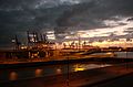
Bremerhaven

Hamburg
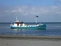
Ferry in the area of the West Frisian Islands


Due to its location in the heavily industrialized north-west Europe, some of the most important ports in Europe are located on the Wadden Sea, and several busy shipping lines lead directly through the sea. Ships from Bremerhaven , Wilhelmshaven , Hamburg , Esbjerg , from the Kiel Canal and from numerous medium-sized and smaller ports inevitably pass through the area. All ship classes and types sail through the shipping routes in the Wadden Sea, from small leisure boats to large tankers and container ships . Among other things, they carry all kinds of dangerous goods, with almost all of the oil that is supplied to north and north-west Europe being of quantitative importance.
Ship traffic affects the Wadden Sea through noise pollution and cargo that has gone overboard, but above all through oil and other chemicals that end up in the water in the event of accidents, but also through illegal disposal. There have hardly been any accidents in the Wadden Sea so far, and the accident rate is extremely low. Between 1995 and 1999 there were almost 800,000 ship movements in the German North Sea, with only 100 incidents, some of which made the use of tugs necessary. The best known and so far most serious of these incidents in the Wadden Sea was the sinking of the Pallas off Amrum .
tourism

The coastal landscape, with its flatness, lack of contours and superficial barreness, represents a challenge for the human senses. Up until the 19th century it was considered to be extremely hostile to life, it was only in the course of the Romantic era that it was reinterpreted, from which early seaside resorts also benefited. From the 1860s and 1870s, painters such as Eugen Bracht , Gustav Schönleber and Eugen Dücker discovered the coastal landscape and, with their paintings, carried the longing into museums and upper-class salons.
The lack of contours was now regarded as a special charm of the vastness, the problems of human settlement were reinterpreted as a special closeness to nature. Even today there are large stretches of land and zones on the water in which water and animal noises are the only sounds that can be heard. Unusually for Central Europe, the Wadden Sea still offers the experience of real darkness .
Every year around ten million tourists visit the Wadden Sea area, and another 30–40 million come as day-trippers. They come mainly from the countries that are themselves on the Wadden Sea. It is estimated that around a third of all jobs in the coastal areas of the Wadden Sea depend on tourism.
The Wadden Sea is accessible to the general public outside the quiet zones of the national parks and nature reserves and specially cordoned off areas. The Wadden Sea has great recreational value on the one hand due to the vastness of its landscape and on the other hand due to the peace and quiet and clean, iodinated air. Experienced mudflat guides explain the special features of this protected natural area in numerous guided mudflat walks .

.jpg)


natural reserve
.jpg)
Due to the uniqueness of the Wadden Sea and the increased awareness of the threat to the system from human uses such as tourism , fishing and shipping since the second half of the 20th century , the Wadden Sea is subject to a number of international protection agreements, which are supplemented by various national nature conservation measures.
As a first step, Denmark, Germany and the Netherlands founded the Wadden Sea Secretariat (CWSS) in 1978 . The trilateral cooperation culminated in the Joint Declaration on the Protection of the Wadden Sea in 1982.
Over a third of the area is Natura 2000 area, which consists of protected areas under the Habitats Directive of 1992 and the Birds Directive of 1979. Most of the Wadden Sea are subject to the Ramsar Convention . With the exception of a few shipping routes, the entire Wadden Sea is subject to various national protective regimes.
The Netherlands designated the Wadden Sea as a state natural monument in 1981 , national parks in the Dutch Wadden Sea are the Schiermonnikoog National Park and the Duinen van Texel National Park . All West Frisian Islands have nature reserves . Denmark included the Wadden Sea in the Nature Conservation Act in 1982. In 1985, the second attempt was made to classify the Schleswig-Holstein Wadden Sea as a national park , followed by the Lower Saxony Wadden Sea a year later . The smallest part of the Wadden Sea, the Hamburg Wadden Sea , was only added to this protected area in 1990.
In 1991 the Agreement on the Conservation of Seals in the Wadden Sea , signed by Denmark, Germany and the Netherlands, came into force.
In 1991, UNESCO recognized the German and Dutch parts of the Wadden Sea as a biosphere reserve and thus placed them under international protection. On June 26, 2009, UNESCO made a positive decision on the joint application by the Netherlands, Lower Saxony and Schleswig-Holstein, but initially not by Hamburg and Denmark, to protect the Wadden Sea as a World Heritage Site . Since June 27, 2011, the Hamburg Wadden Sea , and since 2014 the Danish Wadden Sea , has also been part of the UNESCO World Natural Heritage "Wadden Sea". The Wadden Sea also falls under Annex V of MARPOL , so that any discharge of pollutants from the ship is prohibited. In 2001 the IMO also designated it as a Particularly Sensitive Sea Area (PSSA), which imposed further restrictions on shipping in favor of environmental protection.
literature
- Common Wadden Sea Secretariat (CWSS) (Ed.): Nomination of the Dutch-German Wadden Sea as World Heritage Site , 2008 as pdf
- Ludwig Fischer, Thomas Steensen, Harm Tjalling Waterbolk: The Wadden Sea . Theiss, 2005, ISBN 3-8062-1984-2
- Christiane Gätje and Karsten Reise (eds.): Wadden Sea Ecosystem. Exchange, transport and material conversion processes . Springer, Berlin 1998, ISBN 3-540-63018-X
- Heike K. Lotze, Karsten Reise et al .: Human transformations of the Wadden Sea ecosystem through time: a synthesis in: “Helgoland Marine Research” (2005) 59, pp. 84–95, doi : 10.1007 / s10152-004-0209 -z
- Ministry of Agriculture, Environmental Protection and Rural Areas of the State of Schleswig-Holstein (MLUL) (Ed.): Report on the review of the Schleswig-Holstein Wadden Sea and Halligen biosphere reserve by UNESCO. Reporting period 1990 to 2005 . June 2005 as pdf
- OSPAR Commission 2000: Quality Status Report 2000, Region II - Greater North Sea . OSPAR Commission, London. as PDF
- Meindest Schroor and Joachim Kühn: Cultural Entity Wadden Sea , published as part of the Lancewad project. as PDF
- Federal Environment Agency and national park administrations of Lower Saxony Wadden Sea / Schleswig-Holstein Wadden Sea (ed.): Environmental Atlas Wadden Sea . (2 volumes: Vol. 1, North Frisian and Dithmarsches Wadden Sea; Vol. 2, Wadden Sea between the mouth of the Elbe and the mouth of the Ems). Eugen Ulmer, Stuttgart 1998/1999, ISBN 3-8001-3491-8 + ISBN 3-8001-3492-6
Web links
- German national parks in the Wadden Sea
- International Wadden Sea Secretariat (English)
- The Lancewad Report (2001): The Cultural Heritage of the Wadden Sea Region (English; PDF; 229 kB)
- Wadden Sea World Heritage Site
- Further information on animals, plants and the Wadden Sea itself, Schutzstation Wattenmeer eV
- Who, how, Watt? - Questions and answers about human influences on the Wadden Sea
- Entry on the UNESCO World Heritage Center website ( English and French ).
- Wadden Sea National Park - Denmark
- LancewadPlan: Integrated Landscape and Cultural Heritage Management and Development Plan for the Wadden Sea Region ( Memento of June 10, 2017 in the Internet Archive ) (Collection of materials on the cultural history of the Wadden Sea Region 2004–2007, internet archive)
Individual evidence
- ↑ UNESCO press release, June 26, 2009
- ↑ Entry on the UNESCO list of the Wadden Sea (English)
- ↑ Alexander Bartholomä, Burghard W. Fleming: Transition between land and sea - The Wadden Sea coast on the North Sea. In: Ernst-Rüdiger Look, Ludger Feldmann (Ed.): Fascination Geology. The important geotopes of Germany. E. Schweizerbart'sche Verlagsbuchhandlung, Stuttgart 2006, ISBN 3-510-65219-3 , pp. 18f.
- ↑ a b c d e f g h i j k l m n o p q r s t Schroor / Kühn p. 1–8
- ↑ a b c d e f g h i j International Maritime Organization: “Identification and Protection of Special Areas and Particularly Sensitive Sea Areas. Designation of the Wadden Sea as a Particularly Sensitive Sea Area. Submitted by Denmark, Germany and the Netherlands. ” As pdf pp. 1–8
- ↑ a b c d e f g h Schroor / Kühn pp. 8-14
- ↑ a b c Environmental Atlas Volume 1, p. 96
- ↑ a b c d e f g Gätje / Reise pp. 529-540
- ↑ a b OSPAR pp. 21-25
- ↑ a b c d e f International Maritime Organization: “Identification and Protection of Special Areas and Particularly Sensitive Sea Areas. Designation of the Wadden Sea as a Particularly Sensitive Sea Area. Submitted by Denmark, Germany and the Netherlands. ” As pdf ( Memento from August 20, 2008 in the Internet Archive ) pp. 8-14
- ^ Hamburg Port Authority: Aquatic information. Hydrological Yearbook 2006 ( Memento from January 31, 2016 in the Internet Archive ) (PDF).
- ↑ a b c d e f g Lotze / Reise pp. 84–88
- ↑ a b Safe Coast: Coastal Flood Risk and trends for the future in the North Sea area. Safecoast project team. The Hague 2008 pp. 26–35 as pdf ( Memento from February 9, 2012 in the Internet Archive )
- ↑ Lotze / Reise pp. 90–92
- ↑ a b MLUL pp. 11-31
- ↑ a b c d e Lotze / Reise pp. 88–90
- ↑ a b c d e f g h i j CWSS pp. 89–93
- ↑ Federal Maritime and Hydrographic Agency: "Sea grasses and green algae in the Schleswig-Holstein Wadden Sea" ( Memento from January 3, 2018 in the Internet Archive )
- ↑ a b Wadden Sea Protection Station: "Plants in the Watt"
- ↑ a b c d Wadden Sea Protection Station: "Animals"
- ↑ a b c Fachschaft Biologie Hannover: "Habitat Salt Meadow - Animals"
- ^ CWSS p. 53
- ↑ Lotze / Reise pp. 92–94
- ↑ Heers u. Behrends: The seal in the Wadden Sea, WWF environmental information, 1984, p. 44
- ↑ https://www.cuxhaven.de/magazin/artikel.php?artikel=2228&type=2&menuid=572&topmenu=551&tabid_10=3
- ^ A b Scottish Natural Heritage: A Review of Relevant Experience in sustainable Tourism in the coastal and marine environment. Case Studies Level 1 - Wadden Sea.
- ↑ Safe Coast: Coastal Flood Risk and trends for the future in the North Sea area. Safecoast project team. The Hague 2008 pp. 17–22 as pdf ( Memento from February 9, 2012 in the Internet Archive )

Cultural heritage:
Aachen Cathedral (1978) |
Speyer Cathedral (1981) |
Würzburg Residence with Hofgarten and Residenzplatz (1981) |
Pilgrimage Church on the Wies (1983) |
Palaces of Augustusburg and Falkenlust in Brühl (1984) |
Cathedral and Michaeliskirche in Hildesheim (1985) |
Roman monuments, cathedral and Church of Our Lady in Trier (1986) |
Historic Hanseatic City of Lübeck (1987) |
Palaces and Parks of Potsdam and Berlin (1990) |
Lorsch Abbey (1991) |
Rammelsberg mine, old town of Goslar and Upper Harz water management (1992) |
Maulbronn Monastery Complex (1993) | Old Town of Bamberg (1993) |
Collegiate Church , Castle and Old Town of Quedlinburg (1994) |
Völklinger Hütte (1994) |
Cologne Cathedral (1996) |
The Bauhaus and its sites in Weimar, Dessau and Bernau (1996, 2017) |
Luther memorials in Eisleben and Wittenberg (1996) |
Classic Weimar (1998) |
Museum Island Berlin (1999) |
Wartburg (1999) |
Dessau-Wörlitz Garden Realm (2000) |
Reichenau Monastery Island (2000) |
Zeche Zollverein and coking plant Zollverein (2001) |
Upper Middle Rhine Valley (2002) |
Old towns of Stralsund and Wismar (2002) |
Bremen Town Hall and Bremen Roland (2004) |
Fürst-Pückler-Park Bad Muskau (2004) |
Limits of the Roman Empire : Upper Germanic-Raetian Limes (2005) |
Old town of Regensburg with Stadtamhof (2006) |
Settlements of Berlin Modernism (2008) |
Prehistoric pile dwellings around the Alps (2011) |
Fagus factory in Alfeld (2011) |
Margravial Opera House Bayreuth (2012) |
Bergpark Wilhelmshöhe (2013) |
Carolingian Westwork and Civitas Corvey (2014) |
Hamburger Speicherstadt and Kontorhausviertel with Chilehaus (2015) |
The architectural work of Le Corbusier : two houses in the Weißenhofsiedlung (2016) |
Caves and Ice Age Art of the Swabian Alb (2017) |
Archaeological border complex Haithabu and Danewerk (2018) |
Naumburg Cathedral (2018) |
Ore Mountains Mining Region (2019) |
Augsburg water management system (2019)
Natural heritage:
Messel Pit (1995) |
Wadden Sea of the North Sea (2009) |
Old beech forests (2011)
Former World Heritage:
Dresden Elbe Valley Cultural Landscape (2004–2009)
Cultural heritage: rune stones , tumuli and Jelling Church (1994) | Roskilde Cathedral (1995) | Kronborg Castle (2000) | Herrnhuter settlement Christiansfeld (2015) | Parforce Hunting Landscape North Zealand (2015) | Kujataa (2017) | Aasivissuit - Nipisat. Inuit hunting grounds between ice and sea (2018)
Natural heritage: Ilulissat Icefjord (2004) | Wadden Sea of the North Sea (2014) | Stevns Klint (2014)
Cultural heritage: Schokland polder landscape (1995) | Fortress belt of Amsterdam (1996) | Historic downtown and harbor of Willemstad (Antilles island of Curaçao) (1997) | Mills in Kinderdijk -Elshout (1997) | Wouda steam pumping station in Friesland (1998) | Beemster Polder (1999) | Rietveld Schröder House (2000) | Canal belt within the Singelgracht in Amsterdam (2010) | Van Nelle Factory (2014)
Natural heritage: Wadden Sea of the North Sea (2009)