Tile plate
| Tile plate | ||
|---|---|---|
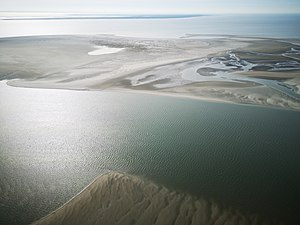
| The Kachelotplate taken from the east, with Borkum behind it | ||
| Waters | North Sea | |
| Archipelago | East Frisian Islands | |
| Geographical location | 53 ° 38 '42 " N , 6 ° 49' 8" E | |
|
|
||
| length | 3 km | |
| width | 1 km | |
| surface | 1.72 km² | |
| Highest elevation | 2.5 m above sea level NN | |
| Residents | uninhabited | |
| Map with the Kachelotplate west of Juist | ||
The Kachelotplate is a high sand that lies in the Lower Saxony Wadden Sea of the North Sea . It was already drawn on a map of the region in 1840 and is now located about five kilometers southwest of the island of Juist , about three kilometers west of the bird island Memmert and about seven kilometers northeast of the island of Borkum . Between 2000 and 2005 it slowly shifted towards Memmert. The name is derived from the French word "cachalot" for " sperm whale ".
Development of the tile plate
In 1975 a little sand had already protruded from the mean high tide , in 2004 the area was 230 hectares , which extended over a length of three kilometers and a width of up to one kilometer. The highest elevations up to 2006 were up to 2.5 m high dunes with the first grass cover, which were leveled again after the severe hurricane flood on October 31 and November 1, 2006 . A laser measurement carried out in 2007 showed an area of only 172 hectares. Since then, the area of the Kachelotplate has not grown any further, but it has become higher. As a result, it is less threatened by flooding and its character is slowly developing into an island. At the same time, compared to other small islands, it migrates quickly to the island of Memmert and is likely to unite with it in the longer term. From 2002 to 2012 the average change in position was 33 meters per year. The Kachelotplate can only be reached by boat.
The Kachelotplate as a biotope
The Kachelotplate is part of the protection zone (Zone I) of the Wadden Sea National Park and may not be entered. It is also not allowed to circumnavigate it with boats or fly over it unnecessarily with airplanes.
In January 2006 it was observed that a group of gray seals had settled on the Kachelotplate in addition to harbor seals . During an inspection on November 29, 2006, two young gray seals were sighted again. Despite the morphological changes in the plate, it still seems to be suitable as a berth for gray seals and common seals. It is believed that a permanent gray seal colony is establishing itself at the east end of the Plate.
- Sandbar with harbor seals and gray seals
Web links
swell
- ↑ Information board on the Have stalemate, Norderney, Source: State Archive of Lower Saxony
- ↑ Manfred Weisensee, Hillrich Smit-Philipp, Janine Tast, Kristina Nebel, Dennis Marczak: Acquisition of geometric and semantic data from the tile plate using airborne and terrestrial laser scanning . Ed .: University of Applied Sciences Oldenburg / Ostfriesland / Wilhelmshaven. 2008 ( jade-hs.de [PDF; 3.3 MB ]).
- ↑ Herma Heyken: Kachelotplate 2007 for research measuring . Lower Saxony State Agency for Water Management, Coastal Protection and Nature Conservation (NLWKN). June 18, 2008. Retrieved May 9, 2009.
- ↑ Ulrich Hellwig, Peter Körber: How fast does Scharhörn migrate? In: Association Jordsand (Hrsg.): SEEVÖGEL: Journal of the association Jordsand for the protection of the sea birds and the nature eV Band 39 , issue 3, June 2018, ISSN 0722-2947 , p. 8 .
- ^ Announcement of the NLWKN from May 8th 2013: Kachelotplate and Memmert are slowly growing together.
- ↑ Kachelotplate is getting closer and closer to Memmert . Lower Saxony State Agency for Water Management, Coastal Protection and Nature Conservation (NLWKN). January 20, 2008. Archived from the original on June 13, 2008. Info: The archive link was automatically inserted and has not yet been checked. Please check the original and archive link according to the instructions and then remove this notice. Retrieved May 9, 2009.
- ↑ Lower Saxony State Agency for Water Management, Coastal Protection and Nature Conservation: Kachelotplate is still subject to constant changes , viewed on September 18, 2012.
|
The next island to the west: Brauerplate |
East Frisian Islands |
The next island to the east: Memmert |


