
Spiekeroog
| coat of arms | Germany map | |
|---|---|---|

|
Coordinates: 53 ° 46 ' N , 7 ° 42' E |
|
| Basic data | ||
| State : | Lower Saxony | |
| County : | Wittmund | |
| Height : | 3 m above sea level NHN | |
| Area : | 18.25 km 2 | |
| Residents: | 809 (Dec. 31, 2019) | |
| Population density : | 44 inhabitants per km 2 | |
| Postal code : | 26474 | |
| Area code : | 04976 | |
| License plate : | WTM | |
| Community key : | 03 4 62 014 | |
| LOCODE : | DE SPI | |
| Address of the municipal administration: |
Westerloog 2 26474 Spiekeroog |
|
| Website : | ||
| Mayor : | Matthias Piszczan ( CDU ) | |
| Location of the community Spiekeroog in the district of Wittmund | ||
  |
||

The North Sea spa Spiekeroog is one of the East Frisian islands in the Lower Saxony Wadden Sea . The island lies between Langeoog and Wangerooge and has an area of 18.25 square kilometers. The closest distance to the mainland is 5.7 kilometers. The municipality of Spiekeroog belongs to the district of Wittmund .
The island is car-free and connected to the Neuharlingersiel port via a ferry . Spiekeroog is the only one of the seven inhabited East Frisian Islands that does not have an airfield. In the port area, a landing pad for helicopters has been set up according to the usual standards. There are restrictions on cycling. Almost 800 people live permanently on Spiekeroog, and tourism is a key economic factor.
The origin of the name Spiekeroog , first mentioned in a document in 1398 as Spickeroch , is controversial.
geography

.png)


Spiekeroog is one of the East Frisian Islands and is located in the 2780 square kilometer Lower Saxony Wadden Sea National Park . Unlike the North Frisian Islands, these islands are not remnants of a coastal landscape that has been eroded by storm surges. Instead, the East Frisian Islands were formed from windblown sandbanks around 5,000 years ago. Due to the tidal currents and the strong prevailing westerly winds, the islands migrate permanently from northwest to southeast. This led to the fact that practically all island villages, once laid out in the middle of the island, can now be found on the western edge of the islands. This migration was only curbed by the fortifications of the island coasts ( coastal protection ) at the beginning of the 20th century.
About 300 years ago the island of Spiekeroog was much smaller. By merging with the islands Lütjeoog and Oldeoog and the diking and draining the Harlebucht it received its present size and shape.
Protection of the island from storm surges
.jpg)
The dunes in the north-west, north, east and south-east of the island are a natural protection of the island over 10.6 kilometers from storm surges with particularly high rising floods. They are maintained by the state of Lower Saxony ( Landesbetrieb für Küstenschutz -NLWKN- ). This is done by plugging in sticks to catch sand, planting beach grass and spreading dried vegetal coverings on bare areas to avoid sand drifts from the sea wind. After sand has broken off in the sea-side area of the dunes due to the impact of waves with high water running up during storm surges, new sand is washed up at the damaged areas and secured using the methods described above. In addition to the protection of the island by the chain of dunes, there are 14 groynes , masonry revetments and the so-called “Schuhmacherwand” from the 1930s in the west and north-west of the island . The latter two should reduce the risk of the island in the western part being breached.
During the storm surge in 1962 , part of the village, including the train station, was flooded. The water came from the mudflats from the east through the Friederiken valley and from the west over the low areas into the village. The 1.6 kilometer long south dike, the main dike to the Wadden Sea, near the village, was therefore rebuilt in the 1970s and the gaps in the east and west between the dike and the dunes were closed. Near the former train station, a gate in the dike allows the horse-drawn tram to run. The gate is usually locked. On the inside of the south dike, the state company built a dike defense path in the 2010s, which is also used as a bypass for goods transports to relieve the inner village.
The area of the Hermann Lietz School to the east of the village was protected in the 1930s by sand dams made of material that was extracted on site and covered with turf. The low height of these dikes, the lack of covering with clay and the steep embankments made it necessary to redesign the protection in this area. The dikes were re-profiled in the 2010s, raised to seven meters and supplemented. In 2018, the NLWKN began in the area northeast of the Hermann-Lietz-Schule, in view of too narrow and too low protective dunes over a length of 400 meters with a widening and elevation of these dunes. In order to make the new dune close to nature, different heights and slopes are planned. This is intended to simulate a typical dune structure. After covering with hay to prevent the sand from being drifted, beach grass is planned to be planted in autumn and winter 2018 to bind the sand, regenerate and integrate it into the surrounding dune landscape. In order to protect the breeding of the seabirds, the start of the work has been scheduled after the breeding phase. The sand can be taken from old low dykes south of the Hermann-Lietz-Schule. These dikes can be dispensed with; removing them creates new salt marshes. The project is also used to remove potato rose areas that are not appropriate to the location and to clean dune areas. The approximately 350,000 euros required are financed from the joint federal-state task to improve the agricultural structure and coastal protection.
Storm surges on the North Sea coast lead to significantly higher water levels at high tide . Together with the stronger waves caused by the storm, this causes extreme stress on the island protection system consisting of dunes, sand deposits and dykes. In the 21st century, there were very severe storm surges on the German North Sea coast on November 1, 2006 ( All Saints Flood 2006 ), November 9, 2007 ( Hurricane Tilo ) and on November 5th / 6th. December 2013 ( Hurricane Xaver ), which also affected Spiekeroog. The December storm surge in 2013 brought Spiekeroog a water level of 271 centimeters above the average flood.
Special protection in the camping area

More and more significant demolitions of the dunes in the area of the campsite in the 2000s resulted in more than two thirds of the dunes being washed away. Sand flushing, the application of sand-filled big bags as well as the insertion of sticks to catch the sand and planting of the remaining dune residue should preserve and stabilize the dunes. In addition, new dunes are created, which are planted with beach grass to stabilize them, because this plant forms particularly deep roots. If the dunes in the north-western area of the island in front of the campsite are broken off further, there is a risk that a storm surge will break through at this point and thus split the island in two. Therefore, in 2017, around 80,000 cubic meters of sand were washed up in front of the campsite almost along its entire length and modeled as dunes. The aim was to widen the remaining dunes in the upper area by around 15 meters and to strengthen the dune body as a whole. During a storm low on January 8, 2019 with wind speeds of 117 km / h, the midday flood reached a level of 1.81 m above the mean high tide. In the area of the campsite, this led to significant sand break-offs from the dunes that were heaped up in 2017, which were planned as wear bodies. The demolition edge reached a height of 1.50 m, in the area of the "Hessenwand" to the west it was twice as high.
Land use
| use | Hectares |
|---|---|
| Building and open space | 46 |
| including living space | 23 |
| of which commercial and industrial space | 1 |
| Operating area | 1 |
| Recreation area | 12 |
| including green area | 3 |
| traffic area | 20th |
| of which road, path, square | 12 |
| Agricultural area | 320 |
| Water surface | 13 |
| Forest area | 13 |
| Areas of other use | 1400 |
| of it land | 1400 |
| total area | 1825 |
Atypical for a North Sea island, Spiekeroog has a comparatively large population of trees. Forests (including rather stunted oaks and black pines, alders , trembling poplars and mountain ash ) are a special feature of the East Frisian Islands, which are characterized by barren sandy soils; they also gave Spiekeroog the nickname "Green Island". The lush expression of dark green crowberry heather on old, so-called “brown dunes” in the interior of the island also contributes to this name . In a figurative sense, “Green Island” also stands for the priority of nature conservation in large parts of Spiekeroog. The "Ostplate" with wide sandy beaches and primary dune formations should be mentioned here in particular. This sand accumulation area makes up more than half of the entire island area and forms one of the most important areas of the East Frisian Islands for bird life. But the north dunes, for example, are also important for birds; many rare species such as the short-eared owl , hen harrier and marsh harrier breed here.
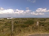
The island village of Spiekeroog is located on the south side of the island facing the mainland. Extensive dune landscapes lie between the beach in the north and west of the island and the village .
history
Until the 19th century
.jpg)
The island was first mentioned in a document in 1398 under the name Spiekeroch . In this deed, Widzeld tom Brok and Folkmar Allena transferred their possessions to Duke Albrecht I of Bavaria , which they also received back as a fief . In the 15th century, the name of the island appeared two more times in documents: in documents from Duke Wilhelm of Bavaria and in a complaint from Chief Ulrich Cirksena that the chiefs of Jeverland who were hostile to him had invaded the island and the inhabitants 100 Robbed sheep.
In 1625, 13 families lived on the island, who earned their livelihood by farming, fishing and the production of shell limestone (Schill). In the period that followed, whaling and shipping became increasingly important. However, this came to a standstill during the Napoleonic occupation due to the continental blockade imposed on the English , which led to great poverty. Only the risky smuggling with the English Heligoland still brought income. In 1812 the English attacked the French positions (" Franzosenschanze ") on the island, but this was repulsed.
The emergence of spa tourism
At the end of the 18th century, seaside resorts based on the English model were founded on the Prussian coast. In 1797, the first seaside resort on the German North Sea coast was built on Norderney .
Spiekeroog, which had 36 apartments around 1800, was visited by holiday guests from 1820 onwards. In 1822 the island had 121 inhabitants and around 1850 134 inhabitants. At that time 30 houses had rooms for vacationers with 79 beds. At that time, self-management was widespread, using the host's kitchen. In the years before 1850 the average number of guests per year was 200.
In the time of Hanover, the island was one of the four sub-bailiffs of the Esens-Kleistrich bailiwick in the old office of Esen.
The sinking of the barque Johanne on November 6, 1854 in front of the Spiekeroog beach cost around 80 lives, mostly emigrants to the USA. In the absence of suitable lifeboats, the islanders could not help the more than 270 passengers and crew members in their fight against the storm. This misfortune, as well as that of the English Brigg Alliance on September 10, 1860 off Borkum, led in 1861 to the establishment of the "Association for the Rescue of Shipwrecked People on the East Frisian Coast" by Georg Breusing in Emden , a forerunner of the DGzRS . On September 7, 1864, the ship Gagnerie ran aground on the northwestern grounds off Spiekeroog . Its five-man French crew was rescued by islanders with a lifeboat.
In order to save bathers the arduous journey through the dunes to the beach, a 1.7 kilometer long horse-drawn tram was opened from the island village to the west beach in 1885 . In 1892 this was extended to the old pier built in 1891 in the southwest of the island. This horse-drawn tram was replaced by diesel vehicles on May 31, 1949, at which time the Spiekerooger Inselbahn was the last horse-drawn tram in Germany.
During the First World War , the outpost boat Moltke of the Imperial Navy stranded on the island during a winter storm on January 2, 1916.
An airfield was established in 1934 and was in operation until 1945.
post war period
On December 1, 1969, Spiekeroog was recognized as a North Sea spa . In 1981 today's port near the village was put into operation and the island railway, which was in need of renovation, was shut down. The old pier has not been used since then and silted up more and more. The remains were dismantled in 2009.
In June 2007, the Spiekeroog gallery and artist house was established as a meeting place for culture professionals and art lovers. On 2500 m² the creative domicile had high-quality equipped studios, workshops and seminar rooms as well as a gallery area. Throughout the year, artists, professors and lecturers offered a variety of creative workshops, seminars and events for experts and learners. Niels Stolberg was the managing director of the operating company . The gallery and artist house Spiekeroog closed on June 1st, 2011 as part of insolvency proceedings.
Origin of the community name
Spiekeroch was first mentioned in a document in 1398, so - in contrast to Norderney - has been bearing his name for centuries. There are several hypotheses about the origin of the community name, none of which have yet been proven. Only the second part of the name Spieker-Oog is unambiguous: "Oog" is a Low German word for island, which is only used in compound words (in the other case "Eiland" would be spoken of). The first part of the name corresponds to both the Low German word for memory and for nail . In his standard work on the East Frisian place names, Arend Remmers points out that the name could have been chosen according to the shape of the island, similar to the neighboring island of Langeoog, which, given the elongated shape of the island, would suggest a comparison with the nail. An older interpretation claims to have recognized a connection with the Old Low German word "specke", which refers to bushes. This should then be understood as an indication of the fortification of the island. Remmers rejects this hypothesis because of the unexplained suffix -er.
politics
Municipal council

The Spiekeroog municipal council consists of eight council members. This is the specified number for a municipality with a population of up to 1000 inhabitants. The eight councilors are elected for five years each by local elections. The current term of office began on November 1, 2016 and ends on October 31, 2021. All members of the municipal council were elected as individual applicants on a single list. The classic political parties do not play a role. The turnout of 63.7% was above the Lower Saxony average of 55.5%.
The full-time mayor is also entitled to vote in the municipal council.
mayor
.jpg)
In the last mayoral elections on June 16, 2014, Matthias Piszczan (CDU) was elected full-time mayor. In the runoff election he received 52.98% of the vote, his opponent Lutz Seifert 47.02%. The turnout was 67.68%. Piszczan took office on November 1, 2014, replacing Mayor Bernd Fiegenheim, who had been in office since 2006 and who did not run again.
Former mayors took on their duties on a voluntary basis according to the Lower Saxony municipal legal regulations that were in effect until 1996 . This could still be applied in smaller communities like Spiekeroog. Claus Ulrich Bauer (1942–2019) became particularly well known. He served as mayor from 1982 to 1986 and 1996-2001. In the years in between, Hans Wiethorn held the office.
Representatives in the Land and Bundestag
Spiekeroog belongs to the state electoral district 87 Wittmund / Insel , which includes the entire district of Wittmund and the towns of Norderney and Wiesmoor , the municipality of Dornum and the island communities of Juist and Baltrum in the Aurich district . 15 parties ran for the state elections in Lower Saxony in 2017 . Six of these parties have put up direct candidates. The directly elected MP is Jochen Beekhuis from the SPD .
Spiekeroog is part of the Friesland - Wilhelmshaven constituency . It includes the city of Wilhelmshaven and the districts of Friesland and Wittmund . The directly elected MP is Siemtje Möller (SPD). No party candidate from the constituency entered the Bundestag via the parties' list.
coat of arms
|
|
Blazon : "In blue over silver natural waves a left-turning two-masted golden ship with silver sails." |
| Justification of the coat of arms: The coat of arms of the island of Spiekeroog dates from 1968. The ship is a medieval Hanseatic cog and is said to be a symbol of earlier trade with the Netherlands. The coat of arms is based strongly on the coat of arms of the district of Wittmund , to which Spiekeroog belongs and on which a cog is also depicted. The municipality of Spiekeroog itself does not fly a flag. |
Culture and sights
Buildings and cultural monuments
In contrast to the other East Frisian island villages, the place Spiekeroog neither had to be relocated nor enlarged or modernized in terms of infrastructure or building fabric in the last few centuries . This favored the preservation of several centuries-old Frisian houses, which together with its narrow paths and old trees give the historic town center a particularly idyllic appearance.
Old island house
The oldest house on the island is the old island house at Süderloog 4, which was built in 1705. Like some of the other old houses on Spiekeroog, the house has a so-called floating roof. Today a café and restaurant is housed in the old island house. Other preserved houses with a floating roof construction are the Drifthuus , the Huus Puppenstuv and the double house Noorderloog 15/17 .
Churches
The Evangelical Lutheran Old Island Church was built in 1696, making it the oldest church on all of the East Frisian islands. It stands between the streets Noorderloog and Süderloog, the two oldest streets in Spiekeroog. The Renaissance style pulpit , images of the apostles and a pietà , which is said to have come from a ship of the Spanish Armada that was stranded off Spiekeroog in 1588 , are sacred objects in this church. In 1961 a new Protestant church was built. In 1971 the church of St. Peter followed for the small Catholic community and holiday guests , which is known as "God's tent in the dunes" because of its architecture.
- Inselkirchen

Old island church

New Evangelical Church
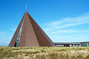
Roman Catholic Church: St. Peter


Drinkeldodenkarkhof

The Drinkeldodenkarkhoff in Tranpad, also known as the homeless cemetery , is a memorial for the victims of the emigrant ship Johanne , which ran aground on November 6th, 1854 off Spiekeroog. As a result of the accident, 77 emigrants lost their lives, including 18 men, 34 women, 18 children under the age of ten and seven babies. The recovered dead were buried on November 9th in a dune valley that was then still outside the village. In 1859 the site was marked with the first iron cross.
Wittbülten National Park House
-0519.JPG)
In March 2006 the Wittbülten National Park House opened its doors to visitors at the Hermann Lietz School Spiekeroog in the eastern part of the island. "Wittbülten" is the Low German name for the first accumulations of sand that lead to the formation of a dune and thus an island. The environmental center shows a permanent exhibition in which the topics of tides , island formation, habitats on the island and the life of marine mammals are presented. The exhibition is complemented by an original sperm whale skeleton and an aquarium.
Museums
The island museum shows exhibits on the history of the island, the development of the seaside resort Spiekeroog and the island's nature. Civil weddings are also carried out in the rooms of the Inselmuseum.
The mussel museum in the guest house "Kogge" shows a humorous exhibition of around 2000 mussels from all over the world.
From April to September (depending on the holiday location) the Spiekerooger Museum Horse Train runs between the train station and the Westend .
Mudflat walks
The Lower Saxony Wadden Sea National Park invites you to observe nature. You can take part in mudflat walks under the guidance of trained mudflat guides. It is also possible to hike to the mainland on foot on suitable routes through the mudflats for several hours. Due to the course of the tidal creeks , one comes ashore near Harlesiel . During the hike, water-bearing troughs have to be waded through several times, even at low tide. Because of the return trip by ferry - a return on foot is not possible due to the rising water - almost a whole day has to be planned for this project. Depending on the tide conditions, mudflat guides offer guided hikes to the mainland in summer for people who are suitable for their physique, followed by a return to the island by ferry.
art
In 2007 the bronze sculpture De Utkieker ( The Lookout ) by Cologne artist Hannes Helmke was unveiled. The 3.50 meter high sculpture of a naked person stands on a viewing dune near the beach hall. The figure looks over the dunes towards the sea.
In 2011 the Berlin sculptor Bernd Finkenwirth created three sculptures from logs that were previously used as dolphins . You are standing on the edge of the road by the port of Spiekeroog.


- Island views

Bronze sculpture de Utkieker by Hannes Helmke on the viewing dune

In the Noorderloog

"Old island house", built around 1700
Dunes at the beach hall

Sculptures from old dolphins


Economy and Infrastructure
tourism


As a North Sea spa, the island has spa facilities such as a spa center, a mother-child spa and an island spa. Spiekeroog has around 3,500 guest beds with all its hotels, guest houses, private rooms, holiday apartments , health resorts and leisure centers. According to a survey from 2003, around 64,000 holidaymakers with 554,000 overnight stays visit the island annually, plus around 81,000 day visitors. The number of registered guests rose by 2.2% from 78,867 to 80,614 in 2006 compared to the previous year. The number of overnight stays rose in 2006 by 4.1% to 565,733. The average length of stay fell to 5.8 days in 2006. In 2012 the number of holidaymakers was 93,578 (597,715 overnight stays) with 6.4 days of stay.
Spiekeroog has joined the marketing organization Die Nordsee GmbH in Schortens for the tourist marketing of the island . The company represents the seven East Frisian Islands and 15 coastal towns in Lower Saxony. It is responsible for joint press work, marketing, holding trade fairs and events, creating print media and classifying private holiday accommodation.
In the past, Spiekeroog was a frequent holiday destination for various federal presidents . So spent Gustav Heinemann , Richard von Weizsäcker and Johannes Rau their holidays. Johannes Rau, in particular, was already on vacation with his family on Spiekeroog as Prime Minister of North Rhine-Westphalia and owned his own holiday home on the island. In 1982, the Rau couple had a church wedding in the Old Island Church. In 2000 Johannes Rau received honorary citizenship of the island.
In addition to hotels, guest houses and holiday apartments, the island in the western part also has a campground that is open from May to September. A popular excursion restaurant is the Laramie in the western part of the island, the building of which was built in 1899 as the first hot bath on the main beach.
media
The spiekerooger inselbote is the only newspaper that appears on the island. The newspaper, founded in 1987, is published by the only journalist on the island, Hartmut Brings, and not only supplies the island's inhabitants, but also a steadily increasing number of so-called mainland subscribers. The island also belongs to the circulation area of the display for Harlingerland and the Ostfriesen-Zeitung . From 2007 to 2010 the free magazine Watt'n Eiland was published quarterly with a print run of 6000 copies, which was primarily aimed at island tourists with stories from and about Spiekeroog. An online newspaper for Spiekeroog called Spiekerooger Inselalldag started in June 2009, but was discontinued in 2011.
traffic


Island traffic
The island of Spiekeroog is car-free except for the emergency vehicles of the voluntary fire brigade. Furthermore, some larger institutions such as the community, the postal and logistics services, the boarding school and the holiday homes are allowed to use narrow, battery-operated minicars. There is also a kind of taxi company with golf-course-typical minicars under the name Inselmobi, which, however, is only allowed to transport old people and the mobility impaired. Otherwise, the handcart is the typical means of transport for luggage and small children on the island.
In contrast to the other East Frisian islands - with the exception of Baltrum - there is no bike rental on Spiekeroog and only very limited opportunities for cycling. Many paths in the center of the village and to the beach are closed to bicycles because of their narrowness. The resort administration advises holiday guests not to bring bicycles to the island. Until recently, guests who want to bring their bicycles paid one euro more for the crossing than for a day return ticket for one person. In the meantime, the prices for bicycle transport have been reduced. Bicycles are often used by the locals and some are loaned out to guests. An attempt to ban bicycles entirely from the island only narrowly missed the majority in the island council.
Spiekeroog is the only inhabited East Frisian island without an airfield. In the port area there is a landing pad for helicopters with the usual standards. It is usually used for the transport of sick people and in severe winters when shipping is closed for food transports as well as for the departure of tourists from the island.
Ferry traffic
The ferry traffic to the port of Spiekeroog takes place via regular connections from the Sielhafen Neuharlingersiel . The island ferries are operated by the Insel Nordseebad Spiekeroog GmbH tourism company. The main ferry traffic is carried out by the ships Spiekeroog I and Spiekeroog II . In April 2010, the newly acquired Spiekeroog IV combined ferry took over the freight transport previously carried out by the Tilde freighter . The combined ferry also carries passengers to a limited extent. The Spiekeroog III was used for excursions and as a reinforcement ship until 2013 and the Spiekeroog Express until 2014 .
Island railway
Until the nearby new port opened in 1981, a diesel-powered island railway operated between the old port and the island village. After the old port ceased operations, the tracks in need of renovation were dismantled, except for the section Bahnhof – Westend. A museum horse-drawn railway started operating on the remaining section of the route . The horse-drawn carriage runs several times a day between the train station and Westend during the summer season. Even at the beginning of the increasing tourism in the time before the First World War , it was possible to take the horse-drawn tram from the village to the beach at that time.
education

Spiekeroog has an island school (elementary school and high school) as well as the Hermann Lietz school as a state-recognized grammar school with a boarding school in private ownership. The school is one of the five Hermann Lietz schools , but has been legally and economically independent from them since 1984. As the other schools in this group reformed educational concept of Hermann Lietz committed.
Flora and fauna
flora

The brown dunes of Spiekeroog are overgrown with crowberry on their north sides, while silver grass, reindeer lichen and cactus moss can be found on the south side . On the south side of the island there are species-rich salt marshes, in which, among other things, couch grass , purslane wedge , sea lavender , beach asters , sagebrush and in the lower salt marsh samphire and beach sod grow. The rare beach winds and the beach thistle also occur on Spiekeroog.
fauna
Birds
.jpg)

In 2017, 71 different bird species brooded on Spiekeroog. Among the breeding birds of the island include oystercatchers , lapwings , godwits , redshank , avocet , curlews , marsh harriers , gray geese , barnacle geese , eider ducks , spoonbills , skylarks , meadow pipits and reed bunting . There are also large colonies of gulls , especially in the east of the island, where herring gulls , herring gulls and common gulls breed. The large breeding population of short-eared owls is also significant . Typical beach breeders such as ringed plover and little tern can be found on the beach and on the offshore sandbanks .
Spiekeroog is also very valuable as a resting place for the bird world. During the main migration period, there are always many resting birds to be found on the island. These find mussels, worms and other small creatures in the mud flats, graze on the salt marshes or look for food on the flushing line. Common breeding birds and regular migrant include Alpine beach runner , large curlews , godwits , oystercatchers , gray plover , ringed plover , Red Knot , sanderlings , Ruddy Turnstone , black-headed gulls , gulls , gulls , terns , wigeon , shoveler , teal , scoter , shelduck , barnacle geese , brent geese , harriers and snow bunting . A total of 315 bird species have so far been identified on Spiekeroog.
Mammals

About 50 deer live on Spiekeroog , whether they were deliberately released on the island or came to the island via the mudflats is unclear. There are also many brown hares on Spiekeroog that were released for hunting purposes after all rabbits on Spiekeroog were exterminated in 1880. Also Muskrats are found on Spiekeroog.
To the east of Spiekeroog there is a sandbank where common seals and gray seals rest.
Others
The rare natterjack toad occurs on Spiekeroog . In addition, 231 species of beetles, 15 species of dragonflies and 43 species of butterflies (17 butterflies and 24 moths) were detected there.
Personalities
- Hans Leuss (1861–1920), born on Spiekeroog, first anti-Semitic member of the Reichstag, later SPD politician.
- Johannes Rau (1931–2006), politician (SPD), the eighth Federal President of the Federal Republic of Germany was an honorary citizen of Spiekeroog from 2000 ; on the advice of his doctor, he spent his vacations on Spiekeroog until his death.
- Wernher von Braun (1912–1977), rocket engineer, did his Abitur early in 1930 at the Hermann Lietz School.
See also
literature
- Municipality of Spiekeroog: Shaping the future together - Texts on the future process from Spiekeroog. Geest-Verlag, Vechta-Langförden 2008, ISBN 978-3-86685-118-4 .
- Gert-Uwe Detlefsen, Robert Geipel: Inselzauber Spiekeroog - pictures of a vacation island. Edition Walfisch, Bremen 2005, ISBN 978-3-938737-00-2 .
- Hans Jürgen Jürgens: Testimonies from a disastrous time. A war diary about the events of 1939–1945 in the area of Wangerooge - Spiekeroog - Langeoog as well as the situation in the Reich and on the fronts. 6th edition. CL Mettcker & Sons, Jever (1989) 2003, ISBN 3-87542-008-X .
- Johannes Meyer-Deepen, Meertinus PD Meijering: Spiekeroog - history of an East Frisian island. Verlag Kurverwaltung Nordseeheilbad Spiekeroog, 3rd edition 1989.
- Johannes Meyer-Deepen, Meertinus PD Meijering: Spiekeroog - natural history of an East Frisian island. Verlag Kurverwaltung Nordseeheilbad Spiekeroog, 1979.
- Arne Petschat, Robert Geipel: The magic of Spiekeroog: Poems of an island. Edition Walfisch, Bremen 2006, ISBN 3-938737-04-2 .
- Manon Loock-Braun: Out and about on Spiekeroog. Natural and cultural-historical island tour. Husum Verlag, Husum 2008, ISBN 978-3-89876-396-7
- Christof Schramm: Heavy seas off Spiekeroog. Edition Beluga bei Mare, Mareverlag, Hamburg 2009, ISBN 978-3-86648-118-3 .
- Johannes Walter: The East Frisian Islands. Seminar of the Institute for Geography of the University of Stuttgart, Stuttgart 2001. Digitized
- Theodor Janssen: About the forces that shape the East Frisian Islands, especially the eastern sandy beach on the island of Spiekeroog , dissertation at the Technical University of Hanover, 1933 partial digitization .
- Historical literature
- J. Voß: The North Sea island Spiekeroog u. the seaside resort there . Praetorius et al. Seyde, 1850. ( Link to digitized version )
- AW Wessel: The North Sea Island Spiekeroog , Verlag Louis Spielmeyer, Aurich 1863 ( link to the digitized version )
- Carl Berenberg: The North Sea islands on the German coast together with their lake bathing establishments , Spiekeroog p. 39ff., Verlag Schmorl & von Seefeld, Hanover 1865 ( link to the digitized version )
- Association of German North Sea Baths (Ed.): The German North Sea Baths: Short Guide , Spiekeroog p. 72ff., 3rd edition, without location, 1901 ( link to digitized version )
Web links
- Official website of Spiekeroog GmbH (spa administration and shipping)
- Spiekeroog from a geographical point of view
- Link to download the general plan for coastal protection islands from the Lower Saxony State Office for Coastal Protection
- Website of the Witbülten National Park Center
Individual evidence
- ↑ State Office for Statistics Lower Saxony, LSN-Online regional database, Table 12411: Update of the population, as of December 31, 2019 ( help ).
- ↑ a b c Press release of the NLWKN of August 14, 2018 , also with a plan for island protection in the area of the Hermann-Lietz-Schule, accessed on August 16, 2018
- ↑ Press release of the Lower Saxony State Office for Water Management, Coastal Protection and Nature Conservation from December 6, 2013
- ^ Lower Saxony State Office for Water Management, Coastal Protection and Nature Conservation: Coastal protection for Spiekeroog - dune reinforcement, Hermann-Lietz-Schule, dyke defense path Süddeich. North (no year, approx. 2011)
- ↑ Information sheet ( Memento of the original from August 27, 2017 in the Internet Archive ) Info: The archive link has been inserted automatically and has not yet been checked. Please check the original and archive link according to the instructions and then remove this notice. of the Lower Saxony State Office for Water Management, Coastal Protection and Nature Conservation , accessed on June 7, 2017.
- ↑ Spiekerooger Inselbote No. 1/2019 of January 26, 2019, pp. 1 and 3
- ^ Karl-Heinz de Wall: Wittmund district. Self-published by the district of Friesland, Jever 1977, p. 260.
- ↑ CP Funke (Ed.): Textbook of geography according to the latest peace provisions, Verlag der Franz Härterschen Buchhandlung, Vienna 1818, p. 131 ( link to the digitized version, accessed on August 5, 2019)
- ↑ Ernst Spangenberg: New patriotic archive, or contributions to the general knowledge of the Kingdom of Hanover as it was and is , born in 1825, from Herold und Wahlstab, Lüneburg 1825, p. 300, ( link to the digitized version , accessed on August 5, 2019)
- ^ J. Voß: The North Sea island of Spiekeroog and the seaside resort there. Verlag Prätorius and Seyde, Aurich / Leer 1850, p. 14. Digitized
- ^ J. Voß: The North Sea island of Spiekeroog and the seaside resort there. Verlag Prätorius and Seyde, Aurich / Leer 1850, p. 21. Digitized
- ^ J. Voß: The North Sea island of Spiekeroog and the seaside resort there. Verlag Prätorius and Seyde, Aurich / Leer 1850, p. 23. Digitized
- ↑ Fridrich Arends: Earth description of the principality of East Friesland and the Harlingerland. Emden 1824. Online in Google Book Search, p. 460, accessed on October 10, 2013.
- ↑ From rowing boats to rescue cruisers. DGzRS, 1990, p. 11 f.
- ^ Künstlerhaus files for bankruptcy , accessed on August 21, 2011
- ↑ weser-kurier.de: Spiekeroog reinterprets Künstlerhaus , accessed on February 3, 2016.
- ^ Arend Remmers: From Aaltukerei to Zwischenmooren. The settlement names between Dollart and Jade. Verlag Schuster, Leer 2004, ISBN 3-7963-0359-5 , pp. 207, 271.
- ^ Lower Saxony Municipal Constitutional Law (NKomVG) in the version of December 17, 2010; Section 46 - Number of MPs , accessed on December 30, 2016.
- ↑ spiekeroog.de: Municipal Council , accessed on December 30, 2016
- ↑ Announcement of the election results, as of September 13, 2016 ( memento of December 30, 2016 in the Internet Archive ), accessed on December 30, 2016.
- ↑ The CDU gets the most votes nationwide. September 12, 2016, accessed December 27, 2016 .
- ^ Website of the CDU Wiefelstede
- ^ Website of the CDU Ammerland
- ↑ Announcement of the election results of the runoff election for mayor in the municipality of Spiekeroog ( memento of August 11, 2014 in the Internet Archive ), accessed on October 25, 2014.
- ^ Spiekeroog: Several candidates for the island. Retrieved October 25, 2014.
- ↑ Obituary notice from November 2019 , accessed on January 4, 2020
- ↑ Obituary notice from the municipality of Spiekeroog from November 2019 , accessed on January 2, 2020
- ↑ Constituency allocation by the Federal Returning Officer , accessed on April 20, 2019.
- ^ Nordwest-Zeitung: Bundestag election: These members represent our region . In: NWZonline . ( nwzonline.de [accessed September 29, 2017]).
- ↑ Hauptstazung. (PDF) Spiekeroog municipality, 2017, accessed on August 9, 2017 .
- ^ The coats of arms and flags of the German Wadden Islands , accessed on October 1, 2009.
- ↑ Church site - Where's the summer?
- ↑ a b c Hermann Lietz School Spiekeroog: History of the Hermann Lietz School Spiekeroog. Online at www.lietz-nordsee-internat.de. Retrieved April 3, 2016.
- ↑ Wittbuelten.de: Wittbülten - The Environmental Center at the Hermann Lietz-Schule . Retrieved September 30, 2009.
-
↑ Description at Watt-erleben.de , access on August 12, 2020
Report at Youtube.com , access on August 12, 2020 - ↑ Hannes Helmke - bronze sculptures
- ↑ Dalbenskulpturen auf Spiekeroog. In: bernd-finkenwirth.de. Retrieved February 3, 2016 .
- ↑ Die Nordsee GmbH - We about us ( Memento from November 26, 2011 in the Internet Archive ), accessed on July 11, 2011.
- ↑ Johannes Rau: Very relaxed on Spiekeroog . (PDF) accessed on September 21, 2009.
- ^ News from an Island , accessed September 30, 2009
- ↑ Spiekerooger Inselbote , accessed on 29 September, 2009.
- ↑ buch-info.org: Watt'n_Eiland ( Memento from March 4, 2016 in the Internet Archive )
- ↑ Online newspaper "Spiekerooger Inselalldag" , accessed on September 24, 2010
- ↑ Spiekeroog 2009 - your island hosts . Nordseebad Spiekeroog GmbH spa administration and shipping, p. 22
- ↑ a b Kulturkampf in Spiekeroog. In: Berliner Zeitung , June 23, 2007.
- ↑ Crossing: Fares , accessed on September 24, 2010.
- ^ Richter's travel guide: North Sea Baths. Germany, Belgium and Holland and cities on the North Sea coast. 2nd Edition. Richter's travel guide publishing house, Hamburg 1914/1915, p. 129.
- ↑ The floristic biodiversity of the East Frisian Islands. Retrieved July 3, 2020 .
- ↑ Spiekeroog. Retrieved July 3, 2020 .
- ↑ a b Edgar Schonart (Ed.): Spiekerooger Ornithological Reports 2017 . Schon-Artig, Spiekeroog 2018.
- ↑ Enno Söker Company: breeding birds on the island Spiekeroog . New edition edition. Esens, ISBN 978-3-941163-24-9 .
- ↑ Enno Söker Company: visiting birds of the island Spiekeroog Volume 1 . 1st edition. Esens, ISBN 978-3-941163-31-7 .
- ↑ Flora & Fauna. Retrieved July 3, 2020 .
- ↑ Biotope for the natterjack toad on Spiekeroog. Accessed July 3, 2020 (German).
- ↑ The beetle species of various family groups on the East Frisian Islands (Coleoptera: Staphyliniformia part., Eucinetiformia, Scarabaeiformia, Elateriformia, Bostrichiformia, Cucujiformia part.). Retrieved July 3, 2020 .
- ↑ The insects of the East Frisian Islands. Retrieved July 3, 2020 .
- ↑ The insects of the East Frisian Islands. Retrieved July 3, 2020 .
Borkum | Bant | Lütje Hörn | Brauerplate | Tile plate | Memmert | Juist | Norderney | Baltrum | Langeoog | Spiekeroog | Wangerooge | Minsener Oog | Mellum
Blomberg | Dunum | Esens | Eversmeer | Friedeburg | Holtgast | Langeoog | Moor path | Nenndorf | Neuharlingersiel | Neuschoo | Ochtersum | Schweindorf | Spiekeroog | Stedesdorf | Utarp | Werdum | Westerholt | Wittmund
|
The next island to the west: Langeoog |
East Frisian Islands |
The next island to the east: Wangerooge |