
Moor path
| coat of arms | Germany map | |
|---|---|---|

|
Coordinates: 53 ° 36 ' N , 7 ° 35' E |
|
| Basic data | ||
| State : | Lower Saxony | |
| County : | Wittmund | |
| Joint municipality : | Esens | |
| Height : | 5 m above sea level NHN | |
| Area : | 18.65 km 2 | |
| Residents: | 858 (Dec. 31, 2019) | |
| Population density : | 46 inhabitants per km 2 | |
| Postal code : | 26427 | |
| Area code : | 04977 | |
| License plate : | WTM | |
| Community key : | 03 4 62 008 | |
| Community structure: | 5 districts | |
| Association administration address: | Am Markt 2 26427 Esens |
|
| Website : | ||
| Mayor : | Jürgen Schröder (FWG) | |
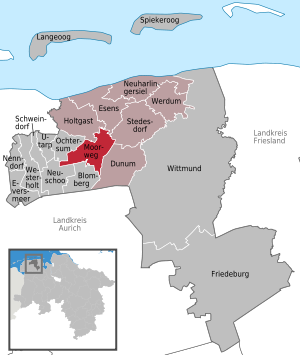
| Location of the municipality of Moorweg in the district of Wittmund | ||
  |
||

Moorweg is a municipality in the Esens municipality in the Wittmund district in Lower Saxony .
geography
location
The municipality is heavily forested. There are several nature reserves in the sparsely populated area. The Burkhard oak, which with its circumference of more than five meters must be more than 400 years old, is outstanding.
Community structure
The community was established in 1972 when the present-day localities Altgaude, Kloster Schoo , Neugaude, Wagnersfehn and Westerschoo were combined.
history
In the area of the municipality of Moorweg, two monasteries were established in the Middle Ages. To the west of the Heron Deep was the Oldekloster monastery , probably laid out as a Benedictine monastery in the 12th century, and to the east of the Heron Deep was the Sconamora monastery (a Premonstratensian monastery from the 13th century called Sconamora). Oldekloster had a Marian shrine and was a place of pilgrimage. After 1421 both monasteries were administered by Marienkamp monastery near Esens and continued as agricultural outposts. With the secularization around 1530, both monasteries passed into the possession of the East Frisian count and were continued as domains. On the map of East Friesland by David Fabricius in 1589 , both monasteries in Harlingerland are named. Around 1770 the Wagnersfehn fen colony was founded by Mrs. Adelheid Wagener from Esens in the moored valley south of Esens. Palatine people were initially settled here, but after the failure of colonization they moved to Pfalzdorf and Plaggenburg near Aurich. The colonization failed because the water pump mill burned down, which was supposed to dry out the raised bog area. The rebuilding of the mill was too much of a financial burden for the founder. From 1850 onwards, most of the sovereign property south of the mossed valley was reforested as Schooer Wald. The former forester's house was in the forest immediately south of the Schoo domain. The Schafhaus domain, a former agricultural branch of the Marienkamp monastery near Esens, is also being reforested as Schafhauser Wald. The former domain building becomes a forester's house, now privatized. The remaining heathland owned by the state was sold in the first third of the 20th century and converted into farms. During the Second World War, an ammunition factory was set up in the Schafhauser Wald on Buchenallee. This includes a bunker that still exists south of the former forester's house. The municipality of Moorweg used to extend much further north to the Esenser Schützenplatz. It was pushed further and further south by the expansion of the city in the 20th century.
politics
Municipal council
The council of the municipality of Moorweg consists of nine councilors. This is the specified number for the member municipality of an integrated municipality with a population between 501 and 1000 inhabitants. The nine councilors are elected by local elections for five years each. The current term of office began on November 1, 2016 and ends on October 31, 2021.
The local council elected councilor Jürgen Schröder as honorary mayor for the current electoral term.
The local election on September 11, 2016 resulted in the following result:
| Political party | Proportional votes | Number of seats | Change voices | Change seats |
|---|---|---|---|---|
| Free Association of Voters (FWG) | 84.96% | 8th | −15.04% | −1 |
| Alliance 90 / The Greens | 15.03% | 1 | + 15.03% | +1 |
The turnout in the 2016 local elections was 57.06%, above the Lower Saxony average of 55.5%. For comparison - in the previous local elections on September 11, 2011, the turnout was 51.58%.
coat of arms
The municipality's coat of arms is divided across. The golden area running from the non-heraldic upper right corner to the non-heraldic lower left corner of the shield shows green oak leaves. The other blue area shows five golden ears of corn overlaid with a golden cross.
Culture and sights
- The ox pasture covers 67 hectares and has been a nature reserve since 1960. The area, which is partly in the municipality of Holtgast, has been part of the Ochsenweide, Schafhauser Wald and Feuchtwiesen near Esens nature reserve since 2019 .
Web links
Individual evidence
- ↑ State Office for Statistics Lower Saxony, LSN-Online regional database, Table 12411: Update of the population, as of December 31, 2019 ( help ).
- ↑ Municipality of Moorweg - Welcome to Moorweg ( Memento of the original from December 30, 2016 in the Internet Archive ) Info: The archive link was automatically inserted and not yet checked. Please check the original and archive link according to the instructions and then remove this notice. , accessed December 29, 2016
- ^ Lower Saxony Municipal Constitutional Law (NKomVG) in the version of December 17, 2010; Section 46 - Number of MPs , accessed on December 29, 2016
- ↑ a b Municipality of Moorweg - overall results of the 2016 municipal council election , accessed on December 29, 2016
- ↑ The CDU gets the most votes nationwide. September 12, 2016, accessed December 27, 2016 .
Dunum | Esens | Holtgast | Moor path | Neuharlingersiel | Stedesdorf | Become
Blomberg | Dunum | Esens | Eversmeer | Friedeburg | Holtgast | Langeoog | Moor path | Nenndorf | Neuharlingersiel | Neuschoo | Ochtersum | Schweindorf | Spiekeroog | Stedesdorf | Utarp | Werdum | Westerholt | Wittmund