Become
| coat of arms | Germany map | |
|---|---|---|

|
Coordinates: 53 ° 40 ' N , 7 ° 43' E |
|
| Basic data | ||
| State : | Lower Saxony | |
| County : | Wittmund | |
| Joint municipality : | Esens | |
| Height : | 2 m above sea level NHN | |
| Area : | 18.45 km 2 | |
| Residents: | 746 (Dec. 31, 2019) | |
| Population density : | 40 inhabitants per km 2 | |
| Postal code : | 26427 | |
| Area code : | 04974 | |
| License plate : | WTM | |
| Community key : | 03 4 62 017 | |
| Community structure: | 3 districts | |
| Website : | ||
| Mayor : | René Weiler-Rodenbäck | |
| Location of the municipality Werdum in the district of Wittmund | ||
Werdum ( Low German Weerm ) is a municipality and climatic health resort in the Samtgemeinde Esens in the Wittmund district in Lower Saxony .
geography
location
Werdum is located in the Harlingerland in East Frisia, just a few kilometers behind the North Sea dike . The coastal town of Neuharlingersiel is about four kilometers north, and Esens about seven kilometers west of Werdum.
Community structure
In addition to Werdum, the municipality includes the districts of Edenserloog and Gastriege . Other places in the municipality are Groß Husum, Klein Husum, Anderwarfen, Wallum and the small Warfdorf Nordwerdum. The center of Werdum has been a climatic health resort since 2000. The outdoor area has been a state-approved resort since 1993.
history
As early as 1191, a castle of the Lords of Werdum was built east of the village in the Edenserloog district , which is still inhabited today. According to tradition, a castle of the influential chief family had already stood on the terp of the St. Nikolai Church. The settlement built on terps was first mentioned in 1297. At that time Werdum was by the sea and had a harbor. It is believed that the Werdumer Siel was located at the site of today's Kapkehörn farm . The place Werdumer Altendeich indicates that near its row of courtyards, probably on the course of today's country road, a dike once protected Werdum from the sea.
The castle
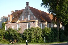
The castle Edenserloog was in the Middle Ages, built on a mound. The von Werdum family , whose best-known member was Ulrich von Werdum (* 1632; † 1681), had the former stone house expanded over the centuries into a castle with defensive towers and surrounded it with a moat. The entrance was in the south. The castle was later used as a farm, with the residential tower being demolished at the beginning of the 18th century. The preserved west wing dates from the Middle Ages. Today the privately owned castle is inhabited and has been open to the public since summer 2009.
There are traditions from the Thirty Years' War that say that the castle was besieged by the Mansfelders . The Werdumers in the castle were to be forced to hand them over by starving them. But with the ruse of showing their last ham with a stick out of the chimney to suggest that they still had enough food, the Mansfelders left.
Werdumer mill

In 1976, the Werdum local history association set up a small local history museum in the Werdumer Mühle , an earth Dutchman established in 1802 . Household items and agricultural implements can be seen. The mill, which is located directly on Edenserlooger Straße, is a functional technical monument and is open to the public.
St. Nicolai Church
The history of the St. Nicolai Church, built on a terp, goes back to the 13th century . It is the church of the Evangelical Lutheran. Parish Werdum, to which Neuharlingersiel also belongs. It was named after Bishop Nikolaus von Myra , who at that time was venerated as the patron saint of boatmen and merchants. South of the church is the cemetery. First church consecration is attested for the year 1327. In 1476 the eastern Gothic choir, today's chancel, was added. The privately donated pulpit was added in 1670. The tower was only built from 1756 to 1763. In 1796 the altarpiece was painted and in 1897 the organ was installed by Johann Diepenbrock . Extensive restorations were carried out between 1982 and 1989 and 2002.
politics
Municipal council
The council of Werdum municipality has nine members. This is the specified number for the member municipality of a joint municipality with a population of 501 to 1000 inhabitants. The municipal council is elected for a five-year term by local elections. The current term of office began on November 1, 2016 and ends on October 31, 2021.
The council elected council member Friedhelm Hass (SPD) as honorary mayor for the current electoral term.
The local election on September 11, 2016 resulted in the following:
| Political party | Proportional votes | Number of seats | Change voices | Change seats |
|---|---|---|---|---|
| Together for Werdum | 100.00% | 9 | + 100.00% | +9 |
mayor
After the Second World War Werdum had three mayors. The first was Wilhelm Janssen, who lived in Nordwerdum and was only deployed by the British occupation and confirmed in elections until 1972. From 1972 to 1994 the community was led by Mayor Ferdinand Eden. In August 1994, Eden resigned from office for health reasons. The council of the municipality of Werdum elected Friedhelm Hass on August 19, 1994 as council chairman, honorary municipality director and mayor.
coat of arms
The coat of arms of the municipality shows the castle Edenserloog on a yellow background in the upper part of the shield. Below is a millstone and symbolizes the still-preserved grain windmill from 1748, which was restored by the municipality in 2002. The millstone is framed by two ears of grain, which indicate the importance of agriculture in the past. Millstones with ears of wheat in the lower part are depicted on a blue background, the blue indicating the proximity of the sea. The blue to the yellow background in the upper part runs in waves.
Culture and sights
The windmill from 1748 with the local history museum opened in 1976 and the St. Nicolai Church from the 13th century are witnesses to the history of Werdum, as is the privately owned castle in the Edenserloog district from the Middle Ages with an older vault. Werdum has a pet park in a central location, in which since 1998 mainly endangered breeds of animals have been shown. There is also a free Kneipp hall, a brewery with a pub and other leisure facilities such as a tennis court, fitness center, mini golf course and a few playgrounds. Werdum also has a volunteer fire brigade.
Sports
SV Werdum is the largest sports club in town. It has almost as many members as Werdum has residents. Sports are football, table tennis, fitness, Jiu Jitsu , gymnastics, bowling and much more.
Economy and Infrastructure
economy
The rural town of Werdum lives from some agriculture and to a large extent from tourism. There are entire holiday home settlements with the appropriate infrastructure such as a tourist information office, spa facilities, shops and localities. As a climatic health resort, Werdum levies a visitor's tax, for which you receive a spa card that is also valid at several other places on the North Sea coast.
traffic
Werdum can be reached via Kreisstraße 14 east of Esens.
Web links
Individual evidence
- ↑ State Office for Statistics Lower Saxony, LSN-Online regional database, Table 12411: Update of the population, as of December 31, 2019 ( help ).
- ↑ Memorial plaque on the object
- ^ "Moin Moin" magazine, June-July 2009 issue
- ↑ Harlingerland Church District: St. Nicolai Church , accessed on January 6, 2016.
- ^ Lower Saxony Municipal Constitutional Law (NKomVG) in the version of December 17, 2010; Section 46 - Number of MPs , accessed on December 29, 2016
- ↑ a b Municipality of Werdum: Municipal Council , accessed on December 29, 2016
- ^ Municipality of Werdum - overall results of the 2016 municipal council election , accessed on December 29, 2016


