
Verona (ship, 1865)
 The Verona during the demolition work about a month after the stranding
|
||||||||||||||||
|
||||||||||||||||
|
||||||||||||||||
|
||||||||||||||||
The Verona was an English steamship that ran aground on the beach at Spiekeroog on December 13, 1883 .
The ship
The journey on which the ship was stranded was to go from Leith (Scotland) to Bremerhaven .
The ship ran aground on the island, bow first. Parts of the ship were dismantled, but a large part of the ship is still there, but not visible, as the ship was quickly washed deep in the sand after being stranded.
The wreck today
The wreck can still be seen at low tide today. Depending on the weather, the masses of sand on the beach shift, so you can sometimes see a lot and rarely nothing at all of the wreck. Mostly, however, a part of the wreck protruding 10 cm to 1 meter from the sand can be seen, which is part of the hull aft on the port side of the ship. In very favorable conditions, however, you can see much more than just a piece of steel protruding from the sand; seldom it is also possible to see the deck of the ship and some superstructures.
position

The ship is stranded with the bow facing the island. Accordingly, the bow of the wreck faces south in the stranded position and the stern faces north. On the compass needle, the ship's bow is at 184.5 °.
The position of the wreck is given very differently. Even in the official nautical charts, the position is shown shifted by more than 100 meters to the south-west. The exact 3 meter position is 53 ° 46 '53.6 " N , 7 ° 47' 16" O . The wreck is just before the SOS point Q marked on the beach. You can see the wreck on Google Earth.

The wreck of the Verona in 2010

The wreck seen from the east
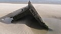
Wreck seen from the south
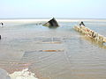
rare: the wreck is almost completely exposed

Wreck high in the sand


Web links
Footnotes
- ↑ History of the island of Spiekeroog ( page no longer available , search in web archives ) Info: The link was automatically marked as defective. Please check the link according to the instructions and then remove this notice.