Coastal defense
Coastal protection measures are intended to protect low-lying, human-used areas near the sea from flooding during storm surges (flood protection), but also to protect the coasts themselves from shrinking banks and loss of land.
In a military context, coastal protection refers to the protection of a coast from attacks or an invasion , especially by building coastal fortresses and keeping troops ready to fight a possible invasion. For example, in occupied France , the Wehrmacht had the Atlantic Wall built to protect the coast from 1940 and kept numerous military units in position along the coast. (see also border protection )
Causes of storm surge water levels are wind congestion or pool oscillations ( Seiches ) in inland seas . In coastal areas and estuaries affected by tides , these phenomena are superimposed on the periodic water level fluctuations ( ebb and flow ). Land and buildings near the coast are therefore usually protected against floods and storm surges with dikes and barriers .
Through the construction of dykes , sluices (drainage systems) and pumping stations (water behind the dam) create new coastal residents or preserve old habitat.
In Germany, the states of Bremen, Hamburg, Mecklenburg-Western Pomerania, Lower Saxony and Schleswig-Holstein operate coastal protection.
Coastal protection is also necessary in the Netherlands, as large areas of the country have been wrested from the sea and are often below sea level behind the dykes.
The maintenance of the Halligen off the north German coast is also part of the coastal protection. These green sandbanks off the coast break the waves of storm surges and protect the dykes on the coast.
The East Frisian Islands are also part of the coastal protection, they are not only so extensively protected because of their great importance for Lower Saxony tourism, they break the waves that come from the North Sea to the mainland, like the Halligen, and thus reduce the pressure on the dykes on the mainland.
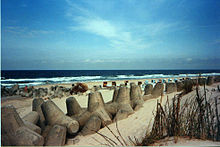
Another coastal protection measure is the washing up of sand in order to create as flat an angle as possible in front of the dike. Dunes are a natural as well as unstable coastal protection and are generally under nature protection in Germany . Since the dunes are only protected from erosion by wind and waves by plants such as the beach aster , entry is prohibited by law. Where the sand is quickly washed away and there are no stones in sufficient quantities to break the waves , concrete is used (see also breakwater )
Rivers
The principles of flood protection are also applied along rivers . Melting snow and / or massive rain showers in the catchment area can cause tidal waves in rivers, which cause the levels to rise rapidly.
In general, the dikes are designed to withstand the pressure of the incoming water. If the top of the dike is flooded, the dike can quickly be washed away and break. Then the water flows unhindered into the hinterland. The dike tops are therefore often specially protected and must not be subjected to mechanical loads. Sheep are ideal for keeping the sward short and firm at the same time. (Muskrats) rats in the dike, on the other hand, endanger stability, as the dyke draws water more quickly through the passages and becomes unstable.
The action of the sea and coastal protection measures
The North Sea coast is not only endangered by storm surges. Since the North Sea is a marginal sea , the tides create currents here that often run parallel to the coast. By the arrangement and the large number of North Sea Islands the water that is located between the islands and the mainland must ebb and flow through the narrow channels ( gating flow therethrough) between the islands; these currents can be so strong that, for example, the Wichter Ee between the islands of Norderney and Baltrum, with a width of only 800 meters, is not considered navigable due to the constantly changing morphology due to the strong currents .
These currents can move significant amounts of sand, causing erosion in the coastal area. You can even move entire islands. This is done by removing sand, transporting it and finally depositing it again in another location. This at least creates sandbanks at a remote location.
The East Frisian Islands move due to the current (primarily due to the Gulf Stream and the location in the area of the westerly winds) to the east, namely by the removal of material (sand) at the western head of the island and deposition at the eastern end, which is why almost all islands meanwhile the place is on the west side. In order to protect the settlements from or during storm surge events, the western head of the islands is in most cases protected from further coastal erosion by massive barriers. These include, for example, the groynes , which usually reach far into the Wadden Sea. B. basalt or granite stone layers, concrete paving and other structures that are used to break the water waves.
Storm surge water levels alone would likely be less of a threat to the coast if they weren't accompanied by extremely strong waves. A real storm surge can be caused by steady winds from one direction for a day or two; a short gust of wind does not make a wave. In order to become really big and strong, a wave has to be pushed by the wind over long distances. This is also the reason why the dikes on the mainland coast are protected by the North Sea islands. The waves that come up here only have the distance between the island and the mainland to absorb energy. They are therefore far less strong than the waves that run towards the islands from the seaward side.
A large amount of energy can be stored in a wave, which can destroy almost everything that humans oppose it. The steeper the coastline, the more energy the wave can give off per meter that it travels. In this case it can have a considerably destructive and erosive effect. The wave runs dead on an inclined plane with a slight incline , but on a steep profile it can effortlessly wash over an equally high crest of the dike and, with its force, increasingly destroy and finally break through the dike. Therefore, the profile of a dike on the side facing the sea should have as little incline as possible. However, this makes it wide, and therefore space-consuming and expensive. Flow obstacles such as B. mussel beds, sandbanks, breakwaters or tetrapods take the force of the wave.
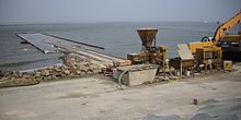
In order to counteract the sand removal near the beach by currents parallel to the coast and the steepening of the coast associated with this, groynes are often built . In places where there is still a wide and high belt of dunes, it is often sufficient to stabilize the dunes by planting them. In the places where there is no space for wide dikes, you have to choose a steeper profile, which then has to be secured by a revetment made of concrete or solid stone blocks. Normally, you build a wide dike with a sand core and a top layer of clay against erosion and plant the dike to protect it with the additional roots against erosion. In places with strong tidal currents, sand flushing can be useful to flatten the coastal profile.
Coastal protection in art and literature
A literary discussion of coastal protection can be found in the novella " Der Schimmelreiter " by Theodor Storm as well as in the crime novels by the author Kari Köster-Lösche with the protagonist Sönke Hansen, who works as a hydraulic engineering inspector at the Husum hydraulic engineering authority.
See also
- Journal of Coastal Conservation
- Coast guard
- integrated coastal zone management
- Coastal fortification
- Reef ball
literature
- Safecoast (2008), COASTAL FLOOD RISK AND TRENDS FOR THE FUTURE IN THE NORTH SEA REGION, synthesis report. Safecoast project team. The Hague as pdf
Web links
- Lower Saxony state company for water management, coastal protection and nature conservation
- Online brochure Coastal Protection in Mecklenburg-Western Pomerania
Individual evidence
- ↑ Description at NLWKN ( Lower Saxony State Agency for Water Management, Coastal and Nature Conservation ), The general plan for island protection from 2011 can be downloaded (right column).


