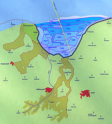
Harle Bay


The Harle Bay was originally a bay about 15 kilometers wide and about 10 kilometers inland to the north of Wittmund in what is now Friesland and East Friesland . The water ingress of the Second Marcellus Flood in 1362 into the hinterland as far as the Geest near Jever created secondary bays and enlarged the Harle Bay enormously. Around 1550 the embankment of the water surface for land reclamation began. Bit by bit, fertile marshland was won with the Elisabethgroden until the end of 1894.
location
The bay extended in the west from Neuharlingersiel to Minsen over a width of about 15 kilometers. Inland it reached about 10 kilometers to Berdum . The area of the former sea floor is still clearly visible on satellite photos.
The coastline in front of the land reclamation is marked from west to east by the Werdumer Altendeich and the old dike foreland Werdumer Altengroden, Altfunnixsiel an der Harle , the Berdumer Altendeich, Altgarmssiel am Tettenser Tief , as well as Medernser Altendeich and Mederns in the Wangerland . The advancement of the dykes and sluices can be read from numerous other street and place names.
The golden line created in the 17th century ran through the middle of the former bay as the border between the Principality of East Friesland and the County of Oldenburg . The reason for their establishment was to avoid disputes about the ownership and drainage of the newly won land.
Exploring by bike
The project: "Experiencing the Harlebucht" (in the double sense of the word: traveling by bike and learning something) started in 1994 by the museum educator of the Alexander von Humboldt School Wittmund for the Sielhafenmuseum Wittmund-Carolinensiel. It was taken up by the regional environmental center RUZ in Schortens and came to a temporary end with the creation of eight bicycle tours in Harle Bay.
Chronological dates
The following events were relevant for Harle Bay:
- 1570: All Saints Flood
- 1598: The Funnixer / Berdumer Altengroden is created and in 1599 receives a drain with the establishment of the Altfunnixsiel.
- 1600: The Harlingerland unites with East Friesland ( Berumer comparison )
- 1637: The Funnixer-Berdumer Neuengroden keeps Altfunnixsiel.
- 1638: The dike of the Garmser Groden begins.
- 1640: The Neugarmssiel is built. Altgarmssiel thereby loses its importance.
- 1658: The Enno-Ludwigs-Groden is dyed and the Neufunnixsiel founded.
- 1675: The Anhaltiner Groden is dyed.
- 1677: The Charlottengroden goes east to Pfahldeich. The expansion does not take place until 20 years later.
- 1698: The Sophiengroden is diked.
- 1700: The Sophiensiel is built. Neugarmssiel thereby loses its importance.
- 1717: Christmas flood (Kassfloot)
- 1729: Dike of the Carolinengroden and foundation of the Carolinensiel
- 1744: East Frisia falls to Prussia (May 26)
- 1765: Frederick the Great's Land Reclamation Edict; Drainage of swamps; Dike of the Friedrichs- and Friedrich-Augusten-Groden and foundation of the Friedrichsschleuse.
- 1776: Own church in Carolinensiel (thus cutting the cord from Funnix).
- 1793: Jever falls to Russia.
- 1802: Schwerinsgroden is first dyed
- 1806: The Neu-Augusten-Groden is dyed
- 1807: East Frisia (and Jever) fall to the Netherlands
- 1811: East Frisia (and Jever) fall to France
- 1815: East Frisia falls to Hanover ( December 15 )
- 1818: Jever falls to Oldenburg
- 1825: Storm surge floods the Schwerinsgroden.
- 1833: New dike completed on a smaller scale.
- 1854 to 1858: the paddle steamer Concordia travels the Harle from Wittmunder Ostermoor to Carolinensiel; smaller ewer bring butter and grain, pottery, rape seed and potterde to the Sielhafen as well as wood (from Norway) and stones (from Holland) and mussels (for the production of shell limestone).
- 1866: Wittmund-Carolinensiel road is built.
- 1894: The Elisabethgroden completes the dike project of the Harlebucht.
literature
- Friedrich Schucht : The Harle Bay, its creation and siltation . Friemann, Aurich 1911.
- Carl Woebcken: Hiking trips through the Friesland . Wilhelmshaven 1982
- Walter Deeters : Small history of East Frisia . Leer 1985.
- Frerich, Eilts: Ollsielle Plum'nmarkt (magazine). Schortens 1993
- Dettmar Coldewey: Frisia Orientalis . Wilhelmshaven 1987
- Andreas-Michael Pajonk: The Harle Bay . Isensee Verlag, Oldenburg 2003, ISBN 3-89598-973-8 .
Web links
- Experience Harle Bay - cycle path in Harle Bay
- Information on the creation and embankment of the Harle Bay and the Golden Line
Individual evidence
- ^ Regional environmental center Schortens: Find out about Harlebucht , accessed on January 16, 2011
- ↑ a b c Experience Harlebucht, circular tour 5. Dykes, Groden and Siele in Wangerland: with a fold-out cycling map . Regional environmental education center Schortens around 2004 ( online (PDF file)).
Coordinates: 53 ° 42 ' N , 7 ° 48' E
