
Jade Bay
| Jade Bay | ||
|---|---|---|
 Jade Bay, Jade and the mouth of the Weser |
||
| Waters | North Sea | |
| Land mass | North German Plain, Lower Saxony, Germany | |
| Geographical location | 53 ° 28 ' N , 8 ° 14' E | |
|
||
| width | approx. 16 km | |
| depth | approx. 18.5 m | |
| surface | 190 km² | |
| Islands | no | |
| Tributaries | Maade , jade | |

The Jade Bay is an approximately 190 km² bay between the Lower Weser and the " East Frisian Peninsula ".
location
It ends at the southern end of the bottleneck between Wilhelmshaven and Butjadingen . To the north of this line are the inner jade and the outer jade , collectively also referred to as jade . The most important cities on the banks of the Jadebusen are Wilhelmshaven in the north-west and Varel in the south-west. The Arngast lighthouse in the Jade Bay serves as a beacon for the Wilhelmshaven Jade fairway.
Natural allocation
The Jade Bay belongs to the main natural unit group Ems- and Wesermarschen (No. 61) of the Watten natural area in the Elbe-Weser triangle Jadebusen . At the upper level, it belongs as part of the marshland to the greater region of the North German Lowlands .
Jade Bay, Jade, Jade Region and Jade Fairway

The Jade Bay is not a continuation of the Jade River (although it flows into the Jade Bay), but, like the Inner and Outer Jade, is part of the German Bight and thus the North Sea . This is defined on the basis of its salinity (salt content), which is 3.0 percent near the mouth of the River Jade, i.e. only 0.5 percentage points less than the salt content of the open North Sea. There is no brackish water zone, unlike in the case of the neighboring Weser estuary . This is mainly due to the very small catchment area of the jade and the correspondingly low input of upstream water. Since the main stream of the Weser water also poured into the Outer Weser in the two centuries when there was a Weser delta, it remains to be seen how the salinity of the Jade Bay was at that time.


In line with its character as a bay, the naming of the water sections differs from those of the neighboring river estuaries : Inner and Outer Jade lie next to the Outer Weser and Outer Elbe . In summary, outer, inner jade and jade bays are referred to as the "jade area". This term can easily be confused with the name of the same name for the adjacent former Prussian enclave in the state of Oldenburg .
In contrast to the inner and outer jade , in the center of which the Jade fairway is located, the Jade fairway, officially called the Jade Federal Waterway , only takes up a small part of the Jade Bay. The federal waterway begins at the level of the former first entrance to the Wilhelmshaven harbors and merges into the inner jade at km 2. The smaller creeks in the Jade Bay are not part of the Jade federal waterway. The Varel fairway, the Ahne and the Kaisebalje are considered to be secondary fairways in the Jade Bay . They are also looked after by the Wilhelmshaven Waterways and Shipping Office, albeit less intensively than the Jade federal waterway.
The tidal range of the Jade is 3.15 m - 4.33 m, which is about as much as at the mouth of the Weser, half a meter less than in Antwerp and a good twice as much as in Rotterdam. With every tidal cycle, almost the entire water content of the Jade Bay flows in through the narrowness of the Jade fairway at high tide and out again at low tide. This natural pendulum current washes the fairway constantly free of any disturbing sand deposits. It is much stronger here than in the mouths of the Elbe and Weser rivers. And the entry of sediments is lower. Only the west-east current between the East Frisian Islands and the East Frisian mainland coast carries sand into the outer mouth of the Jade fairway. But this is counteracted by dams and other river structures at Minsener Oog , see. a. at external jade . Together, this means that much less maintenance work is required for the fairway depth than with other ports.
History of the bay
Emergence

→ Enlargements: • 33% (216 dpi) , • 50% (144 dpi)
There was a "primeval Jade Bay" already 5,000 years ago. The gullies, interpreted by some as the mouths of a Weser delta, are offshoots of a tidal creek system that extended from the Ur-Jadebusen a little way into the Wesermarsch and ran out there in the area of Seefeld, Schwei and Rönnelmoor. The Wadden Sea of the Ur-Jade Bay is from 3100 BC. Largely silted up, with fens initially spreading and around 1900 BC. A rapid and widespread transition from fen to raised bog vegetation took place.
The bay is similar to the Dollard , the result of marine inroads into storm surges in the Middle Ages , favored not only by the rise in sea level by the removal of the original Moore man-made for the use of peat as fuel, as a supplier of salt and for cultivation. The original moor landscape was up to four meters above the marshland and was therefore reasonably flood-proof even without embankment. This moor landscape was separated from the open sea and the Weser by its broad embankments , which consisted of alluvial sediments . They were relatively resistant to erosion , held off normal tidal floods and became a little higher when flooded by storm surges and river floods due to a new layer of sediment. Only in the north was there an opening through which the inland water flowed off. From the 13th century onwards, larger and larger water masses penetrated this point, washed out a deep channel and washed away the protective embankments. The development of the Jade Bay probably began with the First Marcellus Flood on January 16, 1219.
Frisian Balje

In the opinion of some of the explorers of the Jade Bay, the sea may have advanced far to the south and formed the Frisian Balje , as salt peat was extracted near Diekmannshausen near today's southern end as early as the 14th century. Others see individual storm surges as the source of the early salinization, after which the water initially ran off again, as it was apparently not yet strong enough to let the moss die off. Further deep incursions took place during the Lucia flood (December 13 and 14, 1287) and in the Clement flood (November 23, 1334). The floods cleared the soft peat soils, so that the Jade Bay expanded in all directions. The process of clearing the bog soils continues to this day in the area of the Sehesteder outer dike bog , of which only small remains have been preserved. In the west, the deep collapse of the Black Brack arose, which cut off the older Maade Bay to the north from its water inflows from the inland, so that it slowly silted up.
The parish of Arngast in the Jade Bay went under in the Clement flood of November 23, 1334. The remaining island of the same name got smaller and smaller, but still had a small village until the 17th century.
Temporary Weser Delta
Due to the interplay of expansions of the Jade Bay and eruptions of the Weser, there was a Weser delta between the 14th and the first years of the 16th century. It was not a classic sedimentation delta , but an estuary delta in which the forces of erosion were in the foreground. Due to the almost missing gradient and the location in the tidal area, it can be assumed that there were changing directions of current in most of the arms of the water. Most of the headwaters of the Weser always got into the sea through the Weser estuary at Blexen .
The first permanent connections between the Jade Bay and the Lower Weser were established in the first half of the 14th century. With the ancestor , before 1319 and possibly formed by the Weser, the island of Butjadingen ("Outer Jade") was separated from the mainland. The market town of Alnte (Haroldsheim) on the south bank of the Ahne opposite Eckwarden was last mentioned around 1428. The Heete formed when Clemens flood rather from the Jade Bay ago. It branched off from the western part of the ancestor and ran north of the same, soon became a shipping route and the new southern border of Butjadingen. At its confluence with the Weser near Atens , the imperial city of Bremen established the Vredeborg in 1407 .

The Second Marcellus Flood (first “Grote Mandränke”) on January 16, 1362 had extremely devastating consequences : It extended the Lockfleth to the east of the moors. Since large areas of bog floated up there, dismembered and driven away, the northern section of the Lockfleth was also called the “ Hoben ”, normally the Frisian word for floating bog. While the tidal currents in the jade increased with the expansion of the Jade Bay, the Lower Weser silted up more and more and stepped over its banks more easily during high water. In 1384 a large breach of the dyke was created north of the village of Harrien, the Harrier Brake (named for the city of Brake that stands there today ) and thus an arm of the Weser that connected the Weser to the Jade Bay via the Lockfleth for 130 years. The breakthrough stretched from the Jade to the southeast to the Weser and ran across the marshland near Schweiburg in the direction of Rodenkirchen and Ovelgönne near Brake . As a result, the Stadland (historical landscape) became an elongated and initially only about three kilometers wide island. From two breaks in the Weser dike north of Elsfleth in 1367, a ramified body of water arose in the Linebrok , which over the years advanced up the Liene to the Moorriem . After 1420 a flood channel formed there through which water crossed alternately from the Weser to the Jade and vice versa. Only after the construction of the salt dike on the upper inland jade at the beginning of the 16th century could the Jademarsch in the north and the Linebrok in the east be successfully drained. To the east near the salt dike, however, there was still a lake called the Great Sea for decades . In the meantime, a new moorland breakthrough arose further north in 1613, through which water from the Frisian bellows occasionally came eastward into the already drained marshes of the Lockfleth, until dykes were also built in the moor at the end of the century, a lake that was created in the channel called Achtermeer .
The Heete, adjoining Jade and Weser at about the same distance from the open sea and therefore rarely washed through by tidal currents, was silted up again in 1450 to the point that it could be separated by dykes, but was still used for local inland navigation for a long time.
Black brack
The Jade Bay reached its greatest extent through three storm surges in rapid succession, the Second Cosmas and Damian Flood on September 26, 1509, an unnamed storm surge on September 9, 1510 and the Antoni Flood on 16/17. January 1511. After that, its western foothills, the Black Brack , extended far inland. The name was given because of the dark color of the water, which was based on the boggy subsoil.
The glories Friedeburg and Gödens belonging to the county of East Friesland were given access to the sea, the land connection between the rule of Jever and the county of Oldenburg was interrupted. During this time, the creeks reached as far as the Maade river , which now flows into the Inner Jade near Rüstersiel . The later founding area of the city of Wilhelmshaven was then on an island. The old Wurten of the Banter parish lay like small Halligen in the mudflats.
Embankment and human design

In the 16th century, extensive dike measures began , which gave the Jade Bay the shape that has essentially been preserved to the present day. On the west side you went from 1525 gradually because initially the marine invasion of criss-crossed by creeks Watt area to convert the "Black Bracks" in the country. In 1575 the rule of Jever, north of the "Black Brack", became part of the County of Oldenburg . A traffic connection existed only to the west via East Frisian area. Therefore, the Oldenburg ruler, Count Anton Günther , tried to establish a safe land connection to his northern part of the country. After long disputes with the county of East Friesland, the Ellenser Damm, which is still present today, was built between 1596 and 1615 . The low-lying area of the "Black Brack" could only be drained and made arable with the construction of drainage systems and sluices . Further embankments of the Jade Bay followed until the 19th century.

The dike on the east side of the Jade Bay was even more tedious than in the west. It turned out to be difficult to build dikes on bog soil. As early as the 15th century, people began to close individual openings. A decisive step was then the closure of the Lockfleth in 1515 by the Counts of Oldenburg in connection with the construction of the Ovelgönne fortress to control the Stadland (historical landscape), which was subject to 1514 . Up until the 18th century there were repeated heavy dike breaches, most recently during the Christmas flood in 1717 . It was only between 1721 and 1725 that the land between the Jade Bay and the Weser was finally diked under the direction of the Oldenburg Landdrosten Sehestedt .
After the expansion of the bay was stopped, they started to push the dyke lines forward again (as had been done on other parts of the coast). In order to have lasting success, one caused by Schlengen (Gebüschverhaue) and later groynes that in the dyke, also Groden called Gleyerde was deposited. As a result, the reclaimed land is in many places higher than the old dike.
In the Reich War Haven Act of 1883 it was stipulated that measures that impaired the current in the Jade fairway required the approval of the Navy . This was to ensure that the amount of water flowing in and out of the Jade Bay with the tides was sufficient to prevent the Jade fairway from silting up. In practice, this led to the end of all land reclamation measures in the Jade Bay and to largely preserving its shape. For the same reason, there were no measures to protect the last islands in the bay. The last remains of the island of Arngast disappeared in 1904 and those of the Oberahnesche fields off the coast of Butjadden in 1940.
Use of the jade bus
shipping
See also: Wilhelmshaven ports
The Jade Bay is apparently well suited as a large natural harbor , as seven eighths of its area is surrounded by land. Nevertheless, it was not accepted as such for centuries.
The construction of permanent harbors was made more difficult by the fact that the boundary between land and sea often changed after storm surges. The collapse of the sea into the Schwarze Brack made it possible, for example, to set up the Neustadtgödens sewerage area . The construction of the Ellenserdamm cut off the former Sielort from direct access to the sea.
There were early attempts to use the jade region as a naval port . The Sibetsburg , which lay on a side arm in the area where Wilhelmshaven is located today, and which temporarily offered the pirates of the Vitalienbrüder a safe haven, can be regarded as a forerunner .
King Christian V of Denmark , as ruler of Oldenburg, ordered the start of construction work on the port of Christiansburg near Varel in 1681 , but the fairway there could not be kept open with the means at the time and silted up again and again. Therefore the project was abandoned in 1693.
Besides the difficulties in maintaining the fairway, it was above all the living conditions in the coastal regions that prevented the construction of a port. Ultimately, only Prussia was able to put this idea into practice after it had bought the so-called jade region from the Grand Duchy of Oldenburg in 1853 and founded Wilhelmshaven there. In the early years of the port's founding, the residents and port construction workers suffered from a lack of drinking water and febrile illnesses that they contracted in the swamps along the Jade. At times 40 percent of the workers were ill, some even became infected with malaria .
The harbor areas south of Wilhelmshaven, even before it was founded, always had only regional significance and could not compete with the large ports on the Elbe , Weser and Ems . The pilotage on the Jade is guaranteed by the members of the Lotsenbrüderschaft Weser II / Jade .
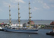
Large harbor in Wilhelmshaven, behind it south beach, lighthouse Dangast, south-east bank of the Jade Bay

Fairway in front of the Varel lock at low tide
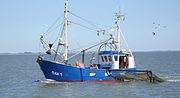
Fishing cutter from Dangast in the Jade Bay


fishing
In 1973 Varel was still the home port of eleven full commercial fishing trawlers . In 2010 there was still a cutter left over. Since 2011, however, another shrimp cutter has landed in Dangast .
tourism
_13.JPG)
Already in 1795 work began on setting up a seaside resort in Dangast , one of the first in Germany. Since then, Dangast has been a seaside resort with the appropriate infrastructure. The place is in the middle of the sculpture path Kunst am Deich . It is favored by the fact that it is located relatively far to the south as a coastal town and is easily accessible via the A 29 and the Varel train station. Boat trips and mudflat walks are possible from Dangast. The south beach in Wilhelmshaven offers another bathing opportunity.
The cycle tourism is defined by two long-distance cycle paths favored. The German sluice route runs parallel to the dike on the east side of the Jade Bay. The Tour de Fries runs through the district of Friesland and follows twice a route along the Jade Bay in Wilhelmshaven and near Varel.
Nature reserve
The Jade Bay is almost entirely part of the Lower Saxony Wadden Sea National Park . A special feature of the Jadebusen is that there are no dunes here (apart from the artificially created “ dune play garden” on Lake Banter in Wilhelmshaven) .
Until 1986, most of the Jade Bay belonged to the " Jadebusen Bird Sanctuary ", a nature reserve placed under protection in 1962 . The Jade Bay is of paramount importance as a feeding, resting, migration and wintering area for waders and water birds. The Jade Bay is attractive for birds because they are largely undisturbed there. There are no ground predators there, and hunting in the Jade Bay has been in place all year round since 1973. The designation as a nature reserve is intended to protect breeding birds in the outer meadows as well as waders, swans, ducks, geese, gulls and terns, which use the exceptionally large food potential of the tidal areas, which consists of mussels, snails, worms and crabs.
The Jade Bay is part of a landscape called "Wadden in the Elbe-Weser Triangle Jade Bay", which the Federal Agency for Nature Conservation identifies.

Salt marshes and tidal flats at low tide, near Augustgroden
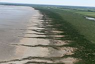
Salt marsh and mud flats at high tide

Salt meadow in front of the sea dike of Cäciliengroden

Mudflats and seagulls at the Varel harbor with bird observation tower during the bird migration days 2012


Floating moor
Until the onset of the sea in the Middle Ages , the area of the Jade Bay was a moor landscape that was washed over by the sea. The last remnant of this moor is the " floating moor " in Sehestedt on the east side of the Jade Bay. It is located between the outer dike and the sea and is Europe's only saltwater raised bog. The moor floats up during a storm surge.
See also
- Jade region
- List of storm surges in the North Sea
- Selected tidal strokes around the North Sea
- Estuary
literature
- Karl-Ernst Behre: The Sehestedt bog - landscape history on the eastern Jade Bay . (Oldenburg Research, Volume 21).
- Karl-Ernst Behre: The history of the landscape around the Jade Bay. Brune-Mettcker, Wilhelmshaven 2012, ISBN 978-3-941929-02-9 .
- David Blackbourn : The Conquest of Nature - A History of the German Landscape. Translated from the English by Udo Rennert. 1st edition. Deutsche Verlags-Anstalt, Munich 2006, ISBN 3-421-05958-6 .
- Heiner Blischke: The march of the southwestern Jade region: history - present - future . In: Oldenburg Yearbook . Vol. 104 (2004), pp. 287-349 ( online )
- Hans Egidius: The Black Brack: A region asserts itself against the forces of nature. CCV Concept Center Verlag, Varel 2000, ISBN 3-934606-00-8 .
- Hans Egidius: The Jade Bay: Origin + History. Komregis Verlag, Oldenburg 2011, ISBN 978-3-938501-33-7 .
- A. Hops: The development of the Jade fairway into a large shipping route. In: Hansa . Year 1966 No. 11, pp. 926–928.
- Waldemar Reinhardt: The development of the watercourses in the area between Maade and Jadebusen since the Middle Ages and their connection with dyke construction . In: Oldenburg Yearbook . Vol. 103 (2003), pp. 9–29 ( online )
- Eilert Schimmelpenning: The Jade Bay and the Black Brack . Schortens 2004, ISBN 3-936691-21-5 .
- Oskar Tenge: The Jeversche Deichband. 1898. Reprint: 1999, ISBN 3-9806956-0-3 , Wangerland to Ellenserdammer Tief
- Oskar Tenge Tenge: 18 cards for the Jeverschen Deichband.
- Copies of an old map of the jade and parts of it 1599–1625. 1884.
- Dike in the area of Sande-Cäciliengroden. (1898 on the basis of maps before 1888), also in Behre (see above) Fig. 124, p. 127.
- Oskar Tenge: The Butjadinger Deichband. 1912. (from including Dangast to the mouth of the Hunt), u. a. in the fund (pre-order) of the Bremen State Archives
- Oskar Tenge: 25 cards for the Butjadinger Deichband. 1912 (PDF)
- G. Sello: The Jade Bay. Varel 1903, OCLC 46305128 .
Web links
- www.umwelt.niedersachsen.de: Water network and coastal waters of Lower Saxony
- Ports on the Jade
- Image archive of the NWO with aerial photos of the Jade region ( Memento from October 4, 2008 in the Internet Archive )
- Information and photos about the Jade Bay
- Representation of changes in the course of the coast over time
- Geological investigations in the area of the former Oberahnsche fields (eastern Jade Bay) (PDF; 4.3 MB)
- Josef Wanke: Die Vitalienbrüder in Oldenburg (1395–1433) , in Oldenburger Jahrbuch des Verein für Altertumskunde Vol. 19 (1911) (PDF)
- H. Goens, B. Ramsauer: Stedingen on both sides of the Hunte ... , in Oldenburger Jahrbuch des Verein für Altertumskunde Vol. 28 (1924), § 11. The Linebrok (PDF)
- Historical individual maps and maps see the list of sources on the map "Jadebusen und Weserdelta"
Sister projects
Individual evidence
- ↑ a b Landscape profile: Wadden in the Elbe-Weser triangle Jadebusen ( Memento of the original from September 16, 2011 in the Internet Archive ) Info: The archive link was automatically inserted and not yet checked. Please check the original and archive link according to the instructions and then remove this notice. , Federal Agency for Nature Conservation, accessed on November 4, 2014
- ^ Department of Biosciences at JW Goethe - University of Frankfurt: Marine Biological Excursion Wilhelmshaven and Helgoland, Summer 2006 ( Memento from February 22, 2014 in the Internet Archive ) (PDF; 2.3 MB), p. 17.
- ↑ Günther Lang: A contribution to the tidal dynamics of the inner jade and the jade buss . In: Bulletin of the Federal Institute for Hydraulic Engineering No. 86. 2003, pp. 33–42
- ↑ IBL UmweltPlanung / City of Wilhelmshaven: Potentials for the use of cooling water at the Wilhelmshaven power station. Aquatic ecology report. Rev. 1.8 of October 26, 2007, p. 62 (PDF; 9.6 MB).
- ↑ WSA Wilhelmshaven: Peilwesen ( Memento of the original from December 16, 2013 in the Internet Archive ) Info: The archive link was inserted automatically and has not yet been checked. Please check the original and archive link according to the instructions and then remove this notice.
- ↑ Tide table for Wilhelmshaven, Neuer Vorhafen ( Memento of the original from July 2, 2017 in the Internet Archive ) Info: The archive link was inserted automatically and has not yet been checked. Please check the original and archive link according to the instructions and then remove this notice.
- ↑ Tide table for Bremerhaven ( page no longer available , search in web archives ) Info: The link was automatically marked as defective. Please check the link according to the instructions and then remove this notice.
- ↑ Tide table for Antwerp
- ↑ Tide table for Rotterdam
- ↑ Hansjörg Streif : The geological development of the Weser valley and the Weser (PDF; 137 kB). 1999, p. 9.
- ↑ Lower Saxony Institute for Historical Coastal Research : Salt peat mining as a possible cause for the formation of the Jade Bay ( Memento of the original from October 29, 2013 in the Internet Archive ) Info: The archive link was automatically inserted and not yet checked. Please check the original and archive link according to the instructions and then remove this notice.
- ^ A b c Karl-Ernst Behre : History of the landscape around the Jade Bay , Wilhelmshaven 2012, ISBN 978-3-941929-02-9 .
- ^ Frank Ahnert: Introduction to Geomorphology , 4th edition. 2009, ISBN 978-3-8252-8103-8 , p. 204.
- ↑ H. Goens: The farms of the advance and the desert land. In: Oldenburg Yearbook. of the Society for Classical Studies Vol. 33 (1929) (PDF)
- ↑ Varel-Christiansburg 2007 ( Memento of the original from February 25, 2014 in the Internet Archive ) Info: The archive link was inserted automatically and has not yet been checked. Please check the original and archive link according to the instructions and then remove this notice. , accessed March 29, 2012.
- ^ Louise von Krohn: Forty years in a German naval port. 2nd Edition. Wilhelmshaven 1981, ISBN 3-920602-07-2 .
- ↑ Peter Stange: Cutter cannot enter the harbor because of the ice drift . Northwest Newspaper . December 10, 2010.
- ↑ Dangast has a shrimp cutter again ( Memento from May 4, 2011 in the Internet Archive ). Northwest Newspaper . April 5, 2011.
- ^ German sluice route , accessed on July 3, 2019
- ↑ Tour de Fries , accessed on July 3, 2019
- ^ North Sea City Wilhelmshaven: Wadden Sea World Heritage Site
- ↑ Klaus Taux: The Oldenburg nature reserves . Oldenburg. Heinz Holzberg Publishing House. 1986, pp. 289-298.
- ↑ "Migratory Bird Days" website

Dollard | Fivel Bay | Bay of Camping | Bay of Sielmönken | Leybucht | Hilgenried Bay | Nessmer Bay | Dornum Bay | Harle Bay | Crildum Bay | Maade Bay | Jade Bay | Black brack