
Oberahnesche fields
The Oberahneschen fields (also: Oberahnische fields , Oberahnsche fields ) are a group of submerged marshland islands in the northeastern Jade Bay south of Eckwarden . They are named after the ancestor of the river arm of the former Weser delta ; today a creek of the Jade Bay is called an ancestor.
Its name means "uncoated areas beyond the ancestors", so it is viewed from Butjadingen.
development
The Oberahnesche fields became islands with the Second Marcellus Flood ( First Grote Mandränke ) of 1362 when they were separated from the mainland.
An Oberahnesches parish is proven in 1613. A map from 1645 shows nine islands, four of which were inhabited. The names of the individual fields were: Oberahnisches or Saphauser Feld , Holtwarder Feld , Schoeffe Hörn , Über Saphuser Heite , Zwische Heiten , Das Große Feld , Sibsen Warff ( Siebsen Warf ), Dickgraffe ( Deichgräfe ), Wehl Ort .
On the Holtwarder Feld was the Wurtdorf Holtwarden , which was destroyed at the latest in the Burchardi flood ( Second Grote Mandränke ) of 1634, while the island existed a little longer.
During the French era of Oldenburg , a large battery was built on the Oberahn fields . In 1850 only the Großer Feld and the Kleiner Feld existed , the latter was a former part of the Großer Feld that was separated at the beginning of the 19th century . In 1883 the Jade Bay, including the Oberahneschen fields, was added to the Imperial War Port of Wilhelmshaven . According to the Reich War Haven Act, “without the approval of the naval station chief”, no embankments or embankments could be made “which would promote sand or silt deposits or siltation”. This meant that no measures could be taken to protect the islands in the Jade Bay, as the tidal currents should also be kept as large as possible with the tidal flats . The law also stipulated that “the breakthrough in the Jade Bay after the Oberahn fields [...] will be removed at the expense of the Reich”. The small field went under in 1890, the large field was used as a sheep pasture until 1936.
The Oberahnesche fields have completely disappeared since 1948 at the latest. However, there is evidence of medieval use (floor scratches, etc.) on the sea floor. The local researcher Heinrich Schütte (1863–1939) used this as evidence of his theory about the lowering of the coast on the North Sea , which is now considered obsolete.
cards
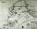
Oberahnesche fields and the recently sealed Hoben (Lockfleth) 1645, tidal range 12 feet

The Jade Bay in the early 19th century with the Oberahnesche fields.

Detailed map of the Oberahnesche fields from 1883 (large field and small field) -

The Oberahnesche fields are still shown on the map from 1906 .

Jade Bay with former islands


literature
- Karl Lüders: The destruction of the Oberahnesche fields in the Jade Bay. In: Treatises of the Natural Science Association Bremen. 30, Bremen 1937, pp. 5-20.
- Oberahnesche fields. In: Werner Brune (Ed.): Wilhelmshavener Heimatlexikon. Second volume: K – R. Brune Druck- und Verlagsgesellschaft, Wilhelmshaven 1987, DNB 870935569 , p. 382 f.
- Dietrich Hagen: Oberahnesche fields. In: Albrecht Eckhardt (Ed.): Oldenburgisches Ortlexikon. Archeology, history and geography of the Oldenburger Land . Volume 2: L-Z. Isensee Verlag, Oldenburg 2011, ISBN 978-3-89995-757-0 , pp. 743 f.
- Michael Ruland, Wolfram Wartenberg: Geological investigations in the area of the former Oberahnschen fields (eastern Jade Bay). (PDF; 4.3 MB) In: Volker Karius et al. (Hrsg.): Dynamic coasts - basics, connections and effects as reflected in applied coastal research. Rostock EUCC, 2011, ISBN 978-3-939206-00-2 , pp. 155-166. (Coastline Reports 17)
Individual evidence
- ↑ Geological investigations in the area of the former Oberahn fields (eastern Jade Bay). ( Memento of the original from February 22, 2014 in the Internet Archive ) Info: The archive link was automatically inserted and not yet checked. Please check the original and archive link according to the instructions and then remove this notice. (PDF; 4.3 MB) In: Dynamic Coasts - Fundamentals, Interrelationships and Effects as Reflected in Applied Coastal Research. Rostock EUCC, 2011, p. 158, accessed on July 18, 2012.
- ↑ Geological investigations in the area of the former Oberahn fields (eastern Jade Bay). ( Memento of the original from February 22, 2014 in the Internet Archive ) Info: The archive link was automatically inserted and not yet checked. Please check the original and archive link according to the instructions and then remove this notice. (PDF; 4.3 MB) p. 161, accessed on July 18, 2012.
- ^ Wilhelm Janßen: The Vareler harbor . Oldenburg 1993, p. 68 ff .
- ↑
- ^ Dietrich Hagen: Oberahnesche fields. In: Albrecht Eckhardt (Ed.): Oldenburgisches Ortlexikon. Archeology, history and geography of the Oldenburger Land. Volume 2: L-Z. Isensee Verlag, Oldenburg 2011, ISBN 978-3-89995-757-0 , pp. 743 f. [1]
Web links
- Table sheet from 1916 (northern part)
- Table sheet from 1940 (southern part)
- Map section from Lecoq 1805-1814
Coordinates: 53 ° 30 ′ 29 ″ N , 8 ° 14 ′ 9 ″ E