Large natural regions of Germany

main unit groups (violet, thinner)
A division of Germany into large natural regions , main units and sub-units primarily takes into account geomorphological , geological , hydrological , biogeographical and pedological criteria in order to divide the landscape into larger uniform areas. Apart from the national external borders, political borders play no role.
In addition to the natural spatial division, there is now also an official division into so-called landscape areas , which is more geared towards the use of the regions by people and accordingly sometimes draws significantly different boundaries.
Basics by the Federal Institute for Regional Studies
The natural structure of Germany, as it is used today by the Federal Agency for Nature Conservation (BfN) as well as by most of the state institutes, is mainly based on the work of the manual of the natural structure of Germany from 1953 to 1962. This divided what is now the federal territory ( at that time: FRG and GDR) into 86 so-called main unit groups with two-digit code numbers between 01 and 90, which in turn were split up into up to 10, in individual cases more main units (three-digit). In the mapping on a scale of 1: 1,000,000 that is part of the manual, the main unit groups were once again summarized in superordinate large regions with the updated map from 1960.
The result was a division of Germany into five (since 1979: six) natural spatial regions (major landscapes) of the 1st order , which are divided into a total of 18 (since 1964: 19) major regions of the 2nd order . The main unit groups represent mainly large regions of the 3rd order , the main units regions of the 4th order . Some large regions of the 2nd order contain only one main unit group ( Mecklenburg-Western Pomerania coastal area , Harz , Thuringian Basin , Obermainisch-Oberpfälzisches Hügelland , southern Alpine foothills ), others summarize large landscapes known by name ( Rhenish Slate Mountains , Southwest German plains ), others group completely new.
In the follow-up work in single sheets 1: 200,000 , which continued into the 1990s and which served to develop regions of the 5th and lower order (decimal places after the three-digit main unit code), it turned out that some of the boundaries of the major regions of the 2nd and 3rd order had to be corrected and in individual cases no longer correspond to the boundaries of the main unit groups. However, this does not play a role in the numbering following the decadic system, which only starts from the 3rd order.
Reorganization by the Federal Agency for Nature Conservation
From 1992 to 1994, Axel Ssymank et al. On behalf of the BfN, the main unit groups 01-90. These were mostly retained within their limits, but in individual cases 2 to 4 main unit groups were combined according to the manual, while in the case of the North and Baltic Seas, one previous group was split into four new ones.
The numbering of the new units D01 to D73 was completely new from north to south and not, as in the manual, in the opposite direction. Therefore it is not compatible with the numbering of the main units and sub-units and has not been accepted in the state offices. Even the BfN itself largely follows the older system of the manual in the system of its landscape profiles.
Ssymank combines the natural areas into eight so-called large landscapes , which are a little less finely subdivided than the large regions of the 2nd order of the Federal Institute for Regional Studies. The only discrepancy between the two systems is the division of the North German lowlands into an east and a west part, which is justified by the climatic division into Atlantic and continental . The boundary is arbitrarily drawn immediately to the east of units D22, D24, D28, D31 and D33.
These large landscapes have not yet been cited in the literature.
Landscape profiles of the Federal Agency for Nature Conservation
The BfN has also commissioned a nationwide breakdown into so-called landscapes , for each of which so-called landscape profiles were created. These primarily served a rough categorization into 28 landscape types , which are divided into a total of 856 landscapes, and the inventory of protected areas and land use. They do not represent a natural structure and were created with relatively little effort; in particular, landscapes were only rarely analyzed on site, but mainly assessed using satellite images and existing lists. In addition, individual pieces of information from the individual sheets 1: 200,000 were summarized as far as they existed.
The landscape profiles have five-digit code numbers, the first three of which usually correspond to the natural spatial unit according to the manual; Metropolitan areas are sorted separately.
List of major regions 1st to 3rd order
The main unit groups, which more or less correspond to major regions of the 3rd order , are subsequently assigned to major regions of the 2nd order and these in turn are assigned to major regions of the 1st order . This subdivision comes mainly from the publications of the Institute for Regional Studies since 1960:
- The first draft by Heinrich Müller-Miny appeared in the updated map for the manual, the overview maps of the individual sheets from 1960 onwards and in the manual 9th delivery (1962)
- In the single sheets from the year of publication 1964, this design was slightly changed:
- The Upper Palatinate-Upper Main hill country rose from the greater region of the 3rd order to a second order.
- The 2nd order Loessbörden region was expanded, especially in the west.
- There was another change in the single sheets from 1979 (sheet 182 Burghausen) up to the last published ones (sheets Munich and Tegernsee 1994):
- The first-order low mountain range region was divided into two major regions, the first-order low mountain range threshold and tiered land
- The structure of natural spaces in Saxony , which has been published and continuously developed since the dissolution of the Institute for Regional Studies, assigns the larger northern part of the main unit group Upper Lusatia to the Loessbörden, so that only the Lusatian mountainous region in the south remains in the low mountain range threshold.
Due to the changes in the Loessbörden area, a few main unit groups are now distributed over two different large regions of the 2nd or even 1st order.
For a better overview, the major regions of the 1st and 2nd order are listed from north to south, and in the second line from west to east. Within a 2nd or 3rd order region, the listing then follows the preceding numbers according to the manual; the numbers according to BfN are put in brackets. Real large regions of the 3rd order are written in bold italics.
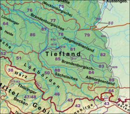
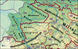
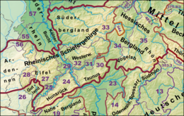
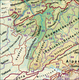
For better orientation, there are detail maps on the right of the lists, all of which are kept to the same scale.
North and east Sea
As an exception, the three-digit main units of Group 90 are listed here, as these de facto represent large regions of the 3rd order.
North Sea
- 900 German Bight (without Heligoland rock base) (D70)
- 901 Doggerbank and adjacent central North Sea (D71)
Baltic Sea
- 902 Western Baltic Sea (D72)
- 903 Eastern Baltic Sea (D73)
North German Lowlands
Marshland
- 61 Ems- and Wesermarschen (D25)
- 67 Lower Elbe lowlands (Elbmarsch) (D24)
- 68 Schleswig-Holstein Marshes and North Sea Islands (D21)
Mecklenburg-Western Pomerania coastal area
- 71 Mecklenburg-Western Pomerania Coastal Area (D01)
Northeast German Lake District
- 70 Schleswig-Holstein hill country (D23)
- Northeast Mecklenburg flatland with Oderhaff area (D02)
- 74 Backland of the Mecklenburg Lake District (D03)
- 75 Mecklenburg Lake District (D04)
-
(to 80 Odertal (D07))
- Main units 800 and 801
Central North German Lowland
-
North German Geest
- Dümmer-Geest lowlands and Ems-Hunte-Geest (D30)
- 60 East Frisian-Oldenburg Geest (D26)
- 62 Weser-Aller-Flachland (D31)
- 63 Stader Geest (D27)
- 64 Lüneburg Heath (D28)
- 69 Schleswig-Holstein Geest (D22)
The north German geest landscape near the North Sea is divided into three parts by the valleys of Weser / Aller and Elbe. The north-eastern part (69) is separated from the central part by the Elbe valley (67 and 87). The mapping of the large regions up to 1963 also showed the parts to the left of Aller and Unterweser (up to 62) and the central part (63/64) as two separate large regions of the 3rd order - a separation that was retained until the last work in 1994. From 1964, however, the extreme north-west of the Elbe Valley Lowlands (87), the Lauenburg Elbe Valley (876.4 according to the Lüneburg sheet of 1980; see dashed line), together with 63, 64 and 69, was drawn as just one major region in the maps of the major regions. Until 1963, Westphalian Bight (54) and Lower Rhine (55/57) were not separated from the Geest landscapes on the left of the Aller as a third order large region.
-
East German plateau and heathland
- Mecklenburg-Brandenburg plateau and hill country (D05)
- 79 East Brandenburg plate (D06)
-
(to 80 Odertal (D07))
- Main units 802 and 803
- Brandenburg Heath and Lake District (D12)
- Lusatian Basin and Spreewald (D08)
- 85 Fläming (D11)
- 86 Wendland and Altmark (D29)
- 87 Elbe valley lowlands (D09)
- 88 Elbe-Mulde-Lowland (D10)
- 89 Upper Lusatian Heideland (D13)
- 54 Westphalian Bay (Münsterländische Tieflandbucht) (D34)
- Lower Rhine or Lower Rhine Plain and Cologne Bay (D35)
Loessbörden
- (to 44 Upper Lusatia (D14))
- Saxon hill country and Erzgebirge foothills (D19)
- 45 Erzgebirge Foreland
- 46 Saxon hill country (including Leipziger Land )
- 50 Central German black earth region (also: Eastern Harz foreland and Börden ; D20)
- 51 Northern Harz Foreland (D33)
- 52 Lower Saxony Börden (D32)
-
(to 37 Weser-Leine-Bergland )
-
(to 378 Calenberger Bergland )
- 378.02 Kleinenbremen Basin
-
(to 378 Calenberger Bergland )
- (to 53 Lower Weserbergland )
Since the Börden - like all major regions - should be simply connected according to the specifications , a small strip of the loess-free Middle Weser Valley around Minden would also belong between the Lübbecker Lößland and the Lower Saxony Börden, along with the Kleinenbremener Basin .
Low mountain range threshold
Rhenish Slate Mountains
(Order from west to east and internally from north to south if necessary)
-
Eifel (D45)
- 56 Vennvorland
- 28 West Eifel
- 27 Eastern Eifel
- 25 Moselle Valley (D43)
- 24 Hunsrück (D42)
- 29 Middle Rhine region (D44)
- 33 Süderbergland (D38)
- 32 Westerwald (D39)
- 31 Gießen-Koblenzer Lahntal (D40)
- 30 Taunus (D41)
The allocation of the basement forest (344, see dashed orange line), which represents a natural part of the Rhenish Slate Mountains, is disputed, but is assigned to the West Hessian mountainous region in the handbook of the natural spatial structure of Germany. Martin Bürgener, editor of the Arolsen paper, adheres to the numbering of the manual, but treats the Kellerwald as part of the Süderbergland (33).
Lower Saxony-Hessian mountainous region
(Order from north to south, secondly from west to east)
-
Lower Saxony highlands (with Weser and Leine highlands)(D36)
- 53 Lower Weser Uplands
- 36 Upper Weser Uplands
- 37 Weser-Leine-Bergland
-
Hessian mountain country
- 34 West Hessian Mountains (D46)
- 35 Osthessisches Bergland (D47)
resin
- 38 resin (D37)
Thuringian Basin
- 47/48 Thuringian Basin (with edge plates) (D18)
Contentious are the assignments of Ohmgebirge along with bleach Röder Bergen (375.2) and the Eichsfelder boiler in the West; the Institute for Regional Studies assigned them to the Lower Saxony mountainous region, while in the literature of the GDR they were mostly viewed as the edge plates of the Thuringian Basin (see deviation of the blue line from the orange line in the west). Another borderline case is the Querfurter Platte (to 489; see deviation of the blue from the black line in the east.
Eastern low mountain range threshold
-
Thuringian-Franconian low mountain range (with Vogtland)
- 39 Thuringian-Franconian low mountain range (D48)
- 41 Vogtland (D17)
- 42 Ore Mountains (D16)
-
Western Sudetes
- 43 Saxon-Bohemian chalk sandstone region (D15)
-
(to 44 Upper Lusatia (D14))
- Main unit 441 Lausitzer Bergland
- 40 Upper Palatinate-Bavarian Forest (D63)
Layer level land on both sides of the Upper Rhine Rift
Palatinate-Saarland layer level country
(Structure from north to south, in the second line from west to east)
-
Triassic Lias region of Lorraine
- 26 Gutland (Bitburger Land) (D49)
-
(to 18 Palatinate-Saarland Muschelkalkgebiet (D50))
- Main units 182 and 183
- 19 Saar-Nahe-Bergland (D52)
- 18 Palatinate-Saarland Muschelkalkgebiet without the Merzig Muschelkalkplatte (D50)
- 17 Palatinate Forest ( Haardt Mountains ) (D51)
Upper Rhine lowlands
(Division from north to south.)
- Upper Rhine lowlands (D53)
Southwest German step country
(Order according to layers of basement rock / red sandstone, shell limestone, Keuper-Lias and Malm from north to south, internally from west to east.)
- 14 Odenwald, Spessart and Südrhön (D55)
- 15 Black Forest (D54)
-
Swabian-Franconian Gau
- 12 Neckar and Tauber Gäuplatten (D57)
- 13 Main Franconian Plates (D56)
-
Swabian-Franconian Keuper-Lias-Land
- 10 Swabian Keuper-Lias-Land (D58)
- 11 Franconian Keuper-Lias-Land (D59)
-
Swabian and Franconian Alb
- 09 Swabian Alb (D60)
- 08 Franconian Alb (D61)
- 16 High Rhine region (Dinkelberg and Hochrheintal) (D69)
Upper Palatinate-Upper Main hill country
Alpine foothills
(Order from north to south, secondarily from west to east)
Northern Alpine Foreland
Southern foothills of the Alps
- Pre-Alpine hills and moorland (=Southern Alpine Foreland; D66)
Alps
Since the Alps have a relatively fine mosaic, the (three-digit) main units are also listed here as an exception.

Northern Limestone Alps
- 01 Northern Limestone Alps
- 010 Rear Bregenz Forest
- 011 Allgäu high alps
- 012 Oberstdorf Basin
- 013 Wetterstein Mountains
- 014 Karwendel Mountains
- 015 Lofer and Leogang Alps
- 016 Berchtesgaden Alps
Swabian-Bavarian Prealps
- 02 Swabian-Bavarian Prealps
- 020 Front Bregenz Forest
- 021 Vilser Mountains
- 022 Ammer Mountains
- 023 Nieder Werdenfelser Land
- 024 Kocheler Mountains
- 025 Mangfall Mountains
- 026 Kufstein basin
- 027 Chiemgau Alps
Different structure according to Dongus and Hormann
The four single sheets 1: 200,000 with Alpine parts appeared relatively late. In the Salzburg newspaper published in 1978, Klaus Hormann suggested abandoning the previous division into groups 01 and 02 and using the numbers from 90, which were not yet assigned on the mainland, for a structure that deviated significantly from the manual. This suggestion was followed by Hansjörg Dongus , who from 1991 to 1994 edited the other alpine leaves (Tegernsee, Kaufbeuren / Mittenwald, Lindau / Oberstdorf) as one of the very last leaves. The structure of the resulting division of the Alps differs significantly from the other divisions, as the individual units in particular are no longer simply connected . Only the main units according to this system are listed below:
- 9 Alps
- 90 basins and valley floors between the main groups of the Alps
- Rhine Valley
- Ill valley
- 900 basins and valley floors in the western part of the Vorarlberg-Allgäu Alps
- 901 Oberstdorf Basin and its side valleys ( Illertal or basin and valley floors in the eastern part of the Vorarlberg-Allgäu Alps )
- 902 Inn Valley
- 907 pools and valley floors on the northern edge of the Kitzbühel Slate Alps
- 908 Inzell Basin
- 909 Salzach-Saalach-Alpenrandbucht
- 91 Eastern Central Alps
- 92 Slate Alps of the Northern Greywacke Zone
- 922 Western Kitzbühel Slate Alps
- 923 Eastern Kitzbühel Slate Alps
- 924 Taxenbach Slate Alps
- 925 Radstadt Slate Alps
- 93 Northern Limestone Eastern Alps
- 930 basins and valley floors between the main groups of the Northern Limestone Eastern Alps
- 931 Allgäu Alps
- 932 Lechtal Alps
- 933 Inntaler reef limestone chains
- 934 Salzburg Plateau Limestone Alps
- 935 Bavarian-Tyrolean Intermediate Limestone Alps
- 936 Marginal chains of the Northern Limestone Eastern Alps or Limestone Alps marginal chains or Limestone Alps
- 937 (no name)
- 94 Flysch Alps
- 940 Vorarlberg and Westallgäu Flysch Alps
- 941 Ostallgäu Flysch Alps
- 942 Trauchgau-Murnauer (Ammergauer) Flysch Alps
- 943 Tölz-Tegernsee-Chiemgauer Flyschalpen
- 944 Western Salzburg Flysch Alps
- 945 Eastern Salzburg Flysch Alps
- 95 Northern Limestone Western Alps
- Alpstein group
- Rätikon
- 950 Vorarlberg-Allgäu Quintner and Schrattenkalk vaults
- 96 Swiss and Allgäu Nagelfluh layer combs
- Gäbris layer combs
- 960 Allgäu Nagelfluh layer combs
- 90 basins and valley floors between the main groups of the Alps
For details and the "translation" into the system of the manual see Natural Spatial Structure of the Alps # Natural Spatial Classification according to Hormann and Dongus !
See also
- Main natural units of Germany (complete list)
- For each country, lists that go beyond the 4th order:
- List of natural spatial units in Baden-Württemberg
- List of natural spatial units in Hessen
- List of the natural spatial units in North Rhine-Westphalia
- List of natural units in Rhineland-Palatinate
- List of the natural spatial units in Saarland
- List of the natural spatial units in Schleswig-Holstein
- Natural areas in Saxony
- The natural areas of Thuringia
- Geomorphological classification of Poland
- Geomorphological classification of the Czech Republic
- Geomorphological classification of Slovakia
Individual evidence
- ↑ The number is explained by the fact that the code 47/48 was used for only one group and the numbers 49, 65 and 66 did not appear.
- ^ Emil Meynen and Josef Schmithüsen : Handbook of the natural spatial structure of Germany . Federal Institute for Regional Studies, Remagen / Bad Godesberg 1953–1962 (9 deliveries in 8 books, updated map 1: 1,000,000 with main units 1960)
- ↑ a b c d e f g h Natural spatial large region maps 1960–1963, 1964–1978 and 1979–1994 according to Müller-Miny et al. (PDF; 1.2 MB)
- ↑ a b The large regions of the 3rd order partially combine several groups.
- ↑ Biogeographical regions and natural spatial main units of Germany (PDF; 216 kB) according to Ssymank (1994), overview and commentary; Federal Agency for Nature Conservation. Attention: In this document, the term main units is misleadingly used for main unit groups (in the sense of the Institute for Regional Studies)!
- ↑ Landscape profiles of the Federal Agency for Nature Conservation ( information )
- ↑ a b c d e f g h i j k l m n o p q r s t Exact name of the Greater Region 2nd or 3rd order unknown!
- ↑ This group was only proclaimed in 1991 and is different from the old group 02, see different structure according to Dongus and Hormann
- ↑ Natural areas of the main unit groups 01 and 02 in the Bavaria Atlas of the Bavarian State Government - Northern Limestone High Alps and Swabian-Bavarian Prealps ( notes )
- ^ Hansjörg Dongus : Geographical land survey: The natural spatial units on sheet 187/193 Lindau / Oberstdorf. Federal Institute for Regional Studies, Bad Godesberg 1991. → Online map (PDF; 6.1 MB)
- ^ Hansjörg Dongus : Geographical land survey: The natural space units on sheet 188/194 Kaufbeuren / Mittenwald. Federal Institute for Regional Studies, Bad Godesberg 1993. → Online map (PDF; 6.4 MB)
- ↑ Hansjörg Dongus : Geographical land survey: The natural space units on sheet 189/195 Tegernsee. Federal Institute for Regional Studies, Bad Godesberg 1994. → Online map (PDF; 5.2 MB)
- ^ Klaus Hormann: Geographical land survey: The natural space units on sheet 190/196 Salzburg. Federal Institute for Regional Studies, Bad Godesberg 1978. → Online map (PDF; 6.1 MB)
- ↑ Sheet Salzburg only extends to 937.1 Osterhorngruppe , so Homann has left the naming of the main unit to later editors in Austria.
literature
- Emil Meynen , Josef Schmithüsen : Handbook of the natural spatial structure of Germany . Federal Institute for Regional Studies, Remagen / Bad Godesberg 1953–1962 (9 deliveries in 8 books, updated map 1: 1,000,000 with main units 1960).
- A. Ssymank: New requirements in European nature conservation. The Natura 2000 protected area system and the "EU Habitats Directive". In: magazine nature and landscape. Volume 69, Issue 9, Bonn-Bad Godesberg 1994, ISSN 0028-0615 , pp. 395-406.
Web links
- Biogeographical regions and natural areas of Germany (PDF; 216 kB) according to Ssymiak (1994), overview and commentary; Federal Agency for Nature Conservation. Attention: The term main units is incorrectly used in this document!
- Map services of the Federal Agency for Nature Conservation ( information )
- Landscape profiles of the Federal Agency for Nature Conservation ( information )
- Classification of the old main units 010–903 and groups 01–90 in the new upper units D01-D73 according to BfN


