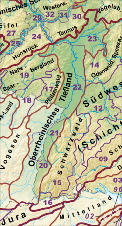
Middle Upper Rhine Lowland
The Middle Upper Rhine Lowland is a main natural spatial unit within the natural structure of Germany and belongs to the second order Greater Region 20–23 (D 53) Upper Rhine Lowland .
Characteristics
It leads No. 21 in the systematics of the manual of the natural spatial structure of Germany by Meynen / Schmithüsen (1953–1962). According to this manual, the area is 1,144.8 km² and between the Rhine and the Black Forest is between 10 and 20 km wide. It extends from the Kaiserstuhl and the Freiburg Bay over 70 km to the NNE up to the Stollhofener Platte .
Natural structure
In the single sheets 1: 200,000 No. 169 Rastatt (1967) and No. 177 Offenburg (1967) of the geographic survey of the Federal Institute for Regional Studies , the Middle Upper Rhine Lowland was subdivided as follows:
- 210 Strasbourg-Offenburg Rhine plain
- 210.0 Rheinaue
- 210.00 Freistetter Rheinaue
- 210.01 Marlener Rheinaue
- 210.02 Ottenheimer Waldaue
- 210.03 Weisweiler forest and bog floodplain
- 210.1 Lichtenau dune field
- 210.2 Rheinbischofsheimer plates
- 210.3 Renchen-Bühler lowland
- 210.30 Renchen-Acher lowland
- 210.31 Bühler lowland
- 210.4 Kinzig-Schutter lowland
- 210.40 Kinzig lowland
- 210.41 Schutter lowland
- 210.5 Offenburg Forest Plate (Schutterwald)
- 210.6 Schutter-Elz low terrace
- 210.60 Ottenheim plate
- 210.61 Meißenheim Old Rhine
- 210.62 Mahlberg-Kippenheimweiler plate
- 210.7 Elz lowlands (Kenzinger lowlands)
- 210.8 Forchheim low terrace slab
- 210.9 Wyhl lowland
- 210.0 Rheinaue
- 211 Lahr-Emmendinger foothills
- 211.0 Lahr foothills
- 211.01 Ettenheimer foothills
- 211.1 Emmendinger foothills
- 211.0 Lahr foothills
- 212 Ortenau-Bühler foothills
- 212.0 Oos foothills
- 212.01 Bühler foothills
- 212.1 Northern Ortenau foothills
- 212.2 Kinzig valley widening
- 212.0 Oos foothills
Web links
- Natural area profile Offenburg Rhine plain (210) - LUBW (PDF; 8.8 MB; information )
- Natural area profile Lahr-Emmendinger Vorberge (211) - LUBW (PDF; 9.4 MB; information ) (Despite its name, this profile deals with the units 211 and 212, which are spatially separated by the Kinzig valley)
Individual evidence
- ↑ Josef Schmithüsen : Geographical Land Survey: The natural spatial units on sheet 169 Rastatt. Federal Institute for Regional Studies, Bad Godesberg 1967. → Online map (PDF; 5.1 MB)
- ^ Friedrich Huttenlocher , Hansjörg Dongus : Geographical land survey: The natural space units on sheet 177 Offenburg. Federal Institute for Regional Studies, Bad Godesberg 1967. → Online map (PDF; 4.0 MB)
