Westeifel
| Westeifel | |||
|---|---|---|---|
| Systematics according to | Handbook of the natural spatial structure of Germany | ||
| Greater region 1st order | Low mountain range threshold | ||
| Greater region 2nd order | 24, 25, 27–33, 344, 56 → Rheinisches Schiefergebirge |
||
| Main unit group | 28 → West Eifel |
||
| Geographical location | |||
| Coordinates | 50 ° 32 ′ 0 ″ N , 6 ° 29 ′ 0 ″ E | ||
|
|||
| state | North Rhine-Westphalia , Rhineland-Palatinate | ||
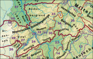
The term Westeifel geographically describes the entire western part of the Eifel with the exception of the Vennvorland . It naturally forms the main unit group 28 . In common parlance, the term West Eifel seldom refers to the entire main unit group described here, but mostly a not exactly defined part of the landscape in the west of the Eifel.
location
In the south, the West Eifel borders the Bitburger Gutland and extends roughly to the Vianden - Bitburg line . The western border corresponds to the border between the Eifel and Ardennes and coincides with the German-French language border , so that parts of the West Eifel lie in Luxembourg and Belgium . The north-western border to the Vennvorland runs along a line Raeren - Langerwehe . In the north, the West Eifel borders the Zülpicher Börde near Düren . The eastern border with the Eastern Eifel runs from Düren in several bays south via Prüm to Bitburg. The West Eifel has a north-south extension of about 90 km. The extension in east-west direction varies between about 10 km near Udenbreth and about 30 km north of Prüm.
Natural structure
In the handbook of the natural spatial structure of Germany , the West Eifel forms the main unit group 28. It is part of the higher-level natural area Rhenish Slate Mountains and consists of the following natural spatial sub-units:
- 28 West Eifel / Ardennes
- 280 Islek and Ösling (designation of the sheets Cochem and Trier; manual: Islek )
- 280.0 Eastern Islek
- 280.1 Middle Islek
- 280.2 West Islek
- 280.3 Middle Ourtal
- 280.4 Southern Schneifel foreland
- 280.5 Islek precursor
- 281 Western High Eifel
- 281.0 Schneifel back
- 281.1 Northern Schneifel foreland
- 281.2 "Grenzwald" ridge
- 281.3 Upper Kylltal
- 281.4 Duppach back
- 282 Rureifel
- 282.0 Düren Eifel foot
- 282.1 Hürtgen plateau
- 282.2 Monschau Heckenland
- 282.3 Rur-Urft-Olef valleys
- 282.4 Monschau-Hellenthaler forest plateau
- 282.5 Dreiborn plateau
- 282.6 Hollerath-Broicher plateau
- 282.7 Wildenburg plateau
- 282.8 Kermeter forest
- 283 High Fens
- 283.0 Venn Plateau
- 283.1 Northern Venn Cover
- Roerquell plateau (all over Belgium)
- Highlands of the upper Warche ( southern foothills of the Fens ; entirely in Belgium)
- Eastern High Ardennes (all over Belgium)
- St. Vither plateau
- 280 Islek and Ösling (designation of the sheets Cochem and Trier; manual: Islek )
West Eifel in common usage
Commonly that part of the Eifel is often subsumed under the name West Eifel, which lies in the vicinity of the city of Prüm up to the border of Belgium and Luxembourg. However, it is not clearly defined geographically (it coincides about 60% with the Schneeeifel ), while the geology assigns the northern part of the corresponding area to the Vulkaneifel and the southern part of the southern Eifel .
The summit corridor reaches somewhat higher heights than the Vulkaneifel, but is usually more gently shaped.
Geographically and topologically, three areas can be distinguished:
- Schneifel - summit ( 699.1 m ) near Schwarzes Mann ( 697.8 m ), mountain range near the Belgian border
- Belgian Eifel - not a uniformly used term
- Islek (in the southwest) - to the German-Luxembourg border
The region is only sparsely populated in the north (Schneifel, etc.), but is cut through by the Autobahn 60 to Malmedy . It is heavily forested and has some relevance for mining (see Bleialf ). In the southern part - in the Prüm valley and its side valleys - there is denser settlement and some tourism, which is promoted by the Southern Eifel holiday route and the Eifel-Ardennes Green Road . This area is part of the German-Luxembourg Nature Park .
Individual evidence
- ↑ E. Meynen , J. Schmithüsen et al: Handbook of the natural spatial structure of Germany - Federal Institute for Regional Studies, Remagen / Bad Godesberg 1953–1962 (9 deliveries in 8 books, updated map 1: 1,000,000 with main units 1960)
- ↑ Online map of the main unit groups with a list of the main units
- ↑ Landscape profile of the large landscape 28 of the landscape information system of the Rhineland-Palatinate nature conservation administration ( information ) (Westeifel)
- ↑ A boundary line between the two plateaus is not drawn on either map, but the Hollerather plateau is largely on the Cochem sheet and the Broicher on the Cologne sheet.

