
Long suffering
| coat of arms | Germany map | |
|---|---|---|

|
Coordinates: 50 ° 49 ' N , 6 ° 21' E |
|
| Basic data | ||
| State : | North Rhine-Westphalia | |
| Administrative region : | Cologne | |
| Circle : | Düren | |
| Height : | 158 m above sea level NHN | |
| Area : | 41.46 km 2 | |
| Residents: | 14,028 (Dec. 31, 2019) | |
| Population density : | 338 inhabitants per km 2 | |
| Postal code : | 52379 | |
| Primaries : | 02423, 02409 | |
| License plate : | DN, JÜL, MON, SLE | |
| Community key : | 05 3 58 032 | |
| LOCODE : | DE LGH | |
| Community structure: | 15 districts | |
| Address of the municipal administration: |
Schönthaler Strasse 4 52379 Langerwehe |
|
| Website : | ||
| Mayor : | Heinrich Göbbels ( CDU ) | |
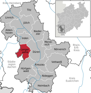
| Location of the municipality of Langerwehe in the Düren district | ||
  |
||


Langerwehe is a municipality in the district of Düren in North Rhine-Westphalia , Germany . It is located on the northern edge of the Hürtgen Forest south of the federal motorway 4 between the cities of Düren in the east and Eschweiler in the west. Part of the municipality is located in the Hohes Venn-Eifel nature park and in the Rureifel .
geography
Geographical location
Langerwehe is located on the Wehebach and on the edge of the Voreifel . The slopes west of the stream have been part of the Hohes Venn-Eifel Nature Park since 2020 . The highest point is on the southern border of the municipality in the Hürtgenwald state forest near the Rennweg at 343 m above sea level. NHN ( ⊙ ). The Nierchen dump is located in the western municipality on the border with Eschweiler .
Expansion of the municipal area
The municipality measures 8.5 km from north to south and 6.5 km from east to west. It covers an area of 41.49 km².
Community structure
| District | Residents (1) |
|---|---|
| D'horn | 377 |
| Homesteads | 101 |
| Equal | 215 |
| Hamich | 842 |
| Heister | 950 |
| Jüngersdorf | 1710 |
| Long suffering | 4196 |
| Luchem | 658 |
| Merode | 688 |
| Obergeich | 348 |
| pier | 782 |
| Crept | 2445 |
| Schonthal | 83 |
| Stütgerloch | 981 |
| Wenau | 23 |
| 14442 | |
| not assigned | 43 |
Neighboring communities
|
in the Düren district
in the Aachen city region
|
|
.svg)
history
The history of the municipality of Langerwehe is presented here. The history of the individual districts, some of which have only belonged to the community since modern times, is presented in their articles.
Long suffering

The central town of Langerwehe itself has grown together from three districts. The oldest part of the village, Rymelsberg , probably dates back to the Franconian times . The first potteries were built there around 1000 and then further workshops down the slope on Aachen-Frankfurter Strasse (old B 264 ) and finally a pottery settlement, the Ules (from the Latin olla = pot ) as the second district . The street name Ulhaus still reminds of this old name. At the intersection of Hauptstrasse and Wehebach, the third district, Zu Wehe, was formed . It gradually grew into a long street village with the Ules . 1664 appeared for the first time in a document, the name of the long woe , from which the current place name later developed.
Pottery, especially the production of Langerweh stoneware , has been the economic power of the village for centuries. In the 14th and 15th centuries, the aachhorn , a specific type of pilgrim horn, was made in Langerwehe . The jury's seal of 1543 already contains three slender beakers in addition to the Jülich lion . The 16th and 17th centuries were the heyday of pottery and thus also of the place.
Langerwehe belonged to the domain of the Duchy of Jülich since the Middle Ages . This was occupied by French troops in 1794 together with the other areas of the German Empire on the left bank of the Rhine and ceased to exist with the annexation in the Peace of Luneville in 1801. Langerwehe now belonged to the canton of Eschweiler together with Hamich, Heistern and Stütgerloch ; Merode, Schlich and D'horn, Jüngersdorf, Geich and Obergeich as well as Luchem belonged to the canton of Düren . Both cantons belonged to the Arrondissement d'Aix-la-Chapelle in the Département de la Roer
After France's defeat in the coalition wars , the political structure of Europe was reorganized at the Congress of Vienna in 1815 and the left Rhineland fell to the Kingdom of Prussia . Langerwehe belonged from 1815 as part of the district of Düren to the administrative district of Aachen in the province of Grand Duchy of Lower Rhine , which was then united with the province of Jülich-Kleve-Berg to form the Rhine province in 1822 .
After the First World War , Langerwehe, like all areas on the left bank of the Rhine, was occupied by the Allies and was not cleared again until 1929. The four places Wenau, Schönthal, Heistern and Hamich came to the administrative area Langerwehe in 1932. With their widely scattered courtyards and other settlement areas, they previously formed the independent community of Wenau.
After the Second World War , the administration in the new Federal Republic of Germany was reorganized. Langerwehe was incorporated into the newly created federal state of North Rhine-Westphalia as part of the Aachen administrative district. On 1 January 1972 as part of were local government reform in North Rhine-Westphalia by applying the Aachen-law , the formerly independent municipalities Langerwehe, Wenau, D'horn, Geich-Oberg calibration , disciples village and Luchem summarized the new municipality Langerwehe. At the same time, the Aachen administrative district was dissolved and Langerwehe and the Düren district were assigned to the Cologne administrative district.
The district of Pier was founded in 2004 as a resettlement site for the residents of Pier (Inden) , which had to give way to the Inden open-cast lignite mine . The relocation was completed in 2013.
.jpg)
History of the Jews in Langerwehe
Jews had been living in Langerwehe since the middle of the 17th century, and there was a prayer room in Hauptstrasse 123 before 1865 . A synagogue was built behind this house in 1874 . About 50 Jews lived in the village at that time. The synagogue was destroyed on November 10, 1938 , during the Night of the Reichspogrom . A memorial plaque has been on the wall of the preserved house since 1999 .
The Jewish cemetery , which was occupied from 1870 to 1936, is located at the exit of the village in the direction of Weisweiler to the right of Bundesstraße 264 . The previous cemetery, which was used until 1870, is also within sight.
politics
|
Local election 2014
Turnout: 57.60% (2009: 60.79%)
% 50 40 30th 20th 10
0
46.43%
34.80%
12.55%
4.44%
1.78%
n. k.
Gains and losses
|
Municipal council
The municipal council is the local people's representative body for the municipality of Langerwehe. The citizens decide on the composition every five years. The last election was the local elections on May 25, 2014 .
mayor
Mayor of Langerwehe is Heinrich Göbbels from the CDU . He was re-elected in September 2015. His first honorary deputy is Hans Uwe Endrigkeit ( SPD ), the second Markus Kuckertz (CDU).
Town twinning
The parish of Langerwehe has been twinned with the English city of Exmouth ( Devon ) since 1985 .
Coat of arms and banner

| The municipality has a coat of arms, a seal and a flag (banner) in accordance with the approval document of the District President of Cologne from August 18, 1972. | ||||||
|
Banner Description of the banner: "Yellow-green in a ratio of 1: 1 striped lengthways with the municipality's coat of arms without a shield in the middle of the upper half." |
|||||
Culture
music school
The Langerwehe Music School is a non-profit organization that offers comprehensive musical training for 300 students. Voluntary sponsor is the Wind Association 1974 Merode e. V.
Pottery Museum
Langerwehe is world-famous for its pottery and has a pottery museum in an old rectory that shows the development of ceramic forms from the early Middle Ages to the present day. It holds many art and technical exhibitions and includes a pottery training workshop. In the museum plan of the Rhineland Regional Association , it is recognized as a special museum worthy of support.
Regular events
- Spring promenade in Merode Castle and Castle Park
- IVPRO Langerwehe summer festival in July
- Pumpkin market at the Kriegerhof in Merode in September
- Eifelmarkt in the pottery museum in September
- Pottery market on the 1st weekend in Advent in the pottery museum
- Romantic Christmas market in Merode Castle and Castle Park
- Wenau Monastery Advent on the 2nd Sunday of Advent in the medieval monastery complex of St. Katharina Wenau
- May festivals in Schlich, Merode, Jüngersdorf, Pier
- Shooting festivals in Langerwehe, Heistern, Pier and Schlich
- Christmas blows by the Merode wind club, usually on the 4th of Advent
- Gospel meets gospel in the pottery museum, in summer
Attractions


The Laufenburg
In the wooded area south of the village of Jüngersdorf on the eastern ridge of the Wehebach valley, the Laufenburg rises on a hilltop. The closed complex with its massive corner towers dates from the 12th century. It houses a farm with a restaurant and is a popular excursion and hiking destination.
Merode Castle
The Merode Castle was built in the 12th century. It is now owned by Prince Charles-Louis von Merode and used privately as a residential building. The castle was severely damaged by a major fire on June 19, 2000, so that many years of renovation work were necessary. It is said, " Merode Castle has as many windows as there are days in the year".
Other structures
Interesting cultural and historical buildings are the parish church St. Martin , the church St. Martinus in Schlich, the old church on the Rymelsberg , the Nikolauskapelle in Geich, the castle Holzheim , the Gutsanlage Schönthal, the Gut Merberich , the ruin of the monastery Schwarzenbroich and the ruin the Karlburg with 2004 restored family vault in landscaped chamber bush . The parish church of St. Katharina in the former Premonstratensian monastery Wenau is open to visitors on the first Sunday of each month.
The former hospital
At the end of the 19th century, cholera raged in the Düren district, as in other regions . Therefore, the mayors from the district met in September 1884 to discuss a district hospital to ward off the danger. Langerwehe was chosen as the location in 1892, also because Richard Schleicher, the owner of the needle factory in Schönthal, made 100,000 marks available from his brother Felix's will .
The management took over the Cellitinnen cooperative , which is still active in Düren today. In July 1894 the new hospital building was inaugurated. The house had 70 beds, an epidemic barrack , an integrated nursing home and a farm building including livestock and a kitchen garden; it was located on Luchemer Straße.
Since the hospital could no longer operate profitably, it was closed on December 31, 1975. The nursing home was closed six months later and demolished in 1978. The senior citizens' dormitory , built in 1981, is located there today .
Economy and Infrastructure

traffic
Langerwehe is conveniently located between the medium-sized centers of Düren and Eschweiler and the regional centers of Aachen and Cologne and has been accessible since December 2015 via its own junction from the federal motorway 4 Cologne- Eindhoven . From the junction, the state road 12 , coming from Inden in the north, runs south through the municipality to Schevenhütte . Langerwehe is connected to Eschweiler in the west and Düren in the east by the federal highway 264 Cologne – Aachen. District road 27 to Kreuzau forms an important link to many of the smaller villages in the area .
The redesigned main street was officially inaugurated in July 2002 and forms the central shopping street of the community.
The station Langerwehe is on the main line between Cologne and Aachen between the stations Düren and Eschweiler Hbf . Since June 2009, Langerwehe has been connected to the Euregiobahn via Eschweiler- Weisweiler and Eschweiler- Talbahnhof with Aachen Hbf parallel to the main Cologne-Aachen line. The railway cycle path runs along this railway line .
Langerwehe is part of the Aachen transport association and is connected to Düren, Lucherberg , Nothberg , Weisweiler and Schevenhütte by bus lines 28, 96, 237, 296 and 261 . The main transfer stop is Langerwehe train station.
Established businesses
The largest employer in Langerwehe is the company alesco GmbH & Co. KG (formerly: Schoeller-Aldo ), which produces packaging materials on the outskirts and in Alsdorf with a total of 250 employees.
education
There are two primary schools in Langerwehe , the Catholic Primary School Langerwehe (Wehebach School) and the Martinus School in Schlich. With the Europaschule Gesamtschule Langerwehe there is also a secondary school offer up to the Abitur . About 1400 students are currently being taught here, some of them in a bilingual English branch. There are six kindergartens in the community (St. Martin Kindergarten, St. Martinus D'Horn, Kindergarten Heistern, Kindergarten Langerwehe-Schlich, Kindergarten Langerwehe-Süd and Kindergarten Jüngersdorf with Pier branch).
Personalities
Born in Langerwehe
- Napoléon Peltzer (1802–1889), cloth manufacturer, born in Wenau
- Hubert Gast (* 1887; † after 1932), trade unionist and politician (center)
- Johannes Kaiser (1936–1996), track and field athlete and Olympic medalist
- Walter Dohmen (* 1941), artist and book author
- Johannes Heinrichs (* 1956), ancient historian
- Peter Münstermann (* 1956), politician (SPD), Member of the State Parliament 2012–2017, born in Schlich, lives in D'horn
- Gabriele B. Clemens (* 1961), historian
- Günter Krieger (* 1965), writer
- Stephan Thiemonds (* 1971), travel writer
Associated with Langerwehe
- Jupp Ernst (1905–1987), graphic artist, industrial designer and educator, died in Langerwehe
- Kurt Jarasinski (1938–2005), show jumper, died in Langerwehe
- Heribert Koch (* 1960), pianist and lecturer, lives in Langerwehe
- Maike Toussaint (* 1985), German actress
- Alfred Wolf (1878–1949), liberal politician, died in Langerwehe
literature
- Heinrich Candels: The Premonstratensian Monastery Wenau. Kühlen, Mönchengladbach 2004, ISBN 3-87448-240-5 .
- Burchard Sielmann: Long woe in old pictures. 2nd Edition. Kämper, Meinerzhagen 1988, ISBN 3-88913-123-9 .
Web links
- Website of the municipality of Langerwehe
- Monuments in the municipality of Langerwehe
- Langerwehe Pottery Museum
Individual evidence
- ↑ Population of the municipalities of North Rhine-Westphalia on December 31, 2019 - update of the population based on the census of May 9, 2011. State Office for Information and Technology North Rhine-Westphalia (IT.NRW), accessed on June 17, 2020 . ( Help on this )
- ↑ https://www.aachener-zeitung.de/lokales/dueren/der-naturpark-nordeifel-reich-nun-bis-in-die-boerde_aid-48307391
- ↑ Highest point Langerwehe. Topographical Information Management, Cologne District Government, GEObasis NRW department, accessed on October 29, 2017.
- ↑ Numbers, data, facts. Langerwehe parish, December 31, 2019, accessed on July 15, 2020 .
- ^ Jan Wiesemann: Around Cologne. Volume 1: The West: Cologne and Jülich Land . Bouvier, Bonn 1991, ISBN 3-416-80681-6 , p. 134.
- ^ History of the community. Langerwehe parish, accessed on April 30, 2019 .
- ^ Federal Statistical Office (ed.): Historical municipality directory for the Federal Republic of Germany. Name, border and key number changes in municipalities, counties and administrative districts from May 27, 1970 to December 31, 1982 . W. Kohlhammer, Stuttgart / Mainz 1983, ISBN 3-17-003263-1 , p. 306 .
- ^ Elfi Pracht-Jörns : Jewish cultural heritage in North Rhine-Westphalia. Bachem, Cologne 1997, ISBN 3-7616-1322-9 .
- ↑ Council election for the municipality of Langerwehe. KDVZ-Frechen, August 30, 2009, accessed April 30, 2019 .
- ↑ Council election for the municipality of Langerwehe. KDVZ-Frechen, May 25, 2014, accessed April 30, 2019 .
- ↑ Mayoral election for the municipality of Langerwehe. KDVZ-Frechen, September 13, 2015, accessed April 30, 2019 .
- ↑ Main statute of the municipality of Langerwehe, § 2 paragraph 1 and 2. ( MS Word ; 82 kB) Retrieved on December 21, 2012 .
- ↑ Pottery Museum. Langerwehe parish, accessed on April 30, 2019 .
- ^ Burchard Sielmann: The former Langerwehe hospital. (PDF) Langerwehe community, accessed on August 30, 2015 .
- ^ Website of the Langerwehe Comprehensive School. Europaschule Gesamtschule Langerwehe, accessed on May 17, 2019 .
Aldenhoven | Düren | Heimbach | Huertgenwald | Inden | Jülich | Kreuzau | Langerwehe | Linnich | Merzenich | Nideggen | Niederzier | Nörvenich | Titz | Vettweiß
D'horn | Equal | Hamich | Heister | Jüngersdorf | Langerwehe | Luchem | Merode | Obergeich | Pier | Sneaked | Schönthal | Stütgerloch | Wenau