
Norvenich
| coat of arms | Germany map | |
|---|---|---|

|
Coordinates: 50 ° 48 ' N , 6 ° 40' E |
|
| Basic data | ||
| State : | North Rhine-Westphalia | |
| Administrative region : | Cologne | |
| Circle : | Düren | |
| Height : | 110 m above sea level NHN | |
| Area : | 66.21 km 2 | |
| Residents: | 10,572 (Dec. 31, 2019) | |
| Population density : | 160 inhabitants per km 2 | |
| Postal code : | 52388 | |
| Primaries : | 02426, 02235, 02421 | |
| License plate : | DN, JÜL, MON, SLE | |
| Community key : | 05 3 58 052 | |
| LOCODE : | DE QOE | |
| Community structure: | 14 districts | |
| Address of the municipal administration: |
Bahnhofstrasse 25 52388 Nörvenich |
|
| Website : | ||
| Mayor : | Timo Czech ( CDU ) | |
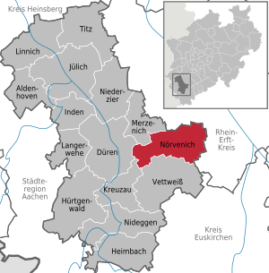
| Location of the municipality of Nörvenich in the Düren district | ||
  |
||


Nörvenich is a municipality in the Düren district in North Rhine-Westphalia , Germany .
geography
Nörvenich is located in the Zülpich Börde . The Neffelbach flows through it from southwest to northeast .
geology
One of the largest brown coal deposits in Germany is located under Nörvenich , the Isweiler field , with 1.396 billion m³, the largest as yet undeveloped deposit in the Rhenish district .
Neighboring communities
The municipality of Nörvenich borders the following municipalities (starting clockwise from the north): Kerpen , Erftstadt (both in the Rhein-Erft district ), Vettweiß , Kreuzau , Düren and Merzenich .
Community structure
Nörvenich consists of 14 districts with the main town Nörvenich (3857 inhabitants on May 31, 2020).
|
Alt-Oberbolheim was one of the districts until 1969 .

According to our own update, the number of inhabitants exceeded the limit of 11,000 on July 31, 2019 (11,020).
history
Traces of the band ceramic culture
At Nörvenich an adze made of amphibolite or green slate from the ceramic period was found, which is 31 cm long. Another blade from Miel is 45 cm long. It is probably the largest blade in Central Europe , the Nörvenicher the second largest. There are many indications that it is not a tool , but an object of prestige .
Celts
Around 2000 BC BC Celts settled in the Nörvenich area . From this time urns were found during excavations in 2015 in a new building area on Zülpicher Strasse. Place names with the ending "(n) I" are considered to be of Celtic origin. The Celts also laid the first paths that the Romans could later use for their purposes.
Ubier and Römer
From about 50 BC The Ubier settled in the Nörvenich area . Caesar had 58 to 51 BC The Eburones were destroyed and the Ubiern from the Lahn-Taunus area on the right bank of the Rhine were offered settlement land here. They then settled on the left bank of the Rhine, also in the local area (approx. 38 to 19 BC). A Roman vicus has been identified adjacent to today's location (→ Vicus Nörvenich ).
middle Ages

The medieval fortress “Noruenich”, first mentioned in 1028, probably emerged from a Roman fort , which was built during the first invasions of Germanic tribes in the 3rd or 4th century. Such bulwarks, surrounded by ramparts and ditches , were built at particularly suitable and practical locations. They were to be opposed to the barbarian onslaught on the left bank of the Rhine , but at the same time they were to offer protection to the population. They had to be adapted to the terrain so as not to make it difficult for the troops to move out quickly. ( Ammianus Marcellinus ). Here in Nörvenich the facility served to protect the old vicus "Norboniacum", the large Roman settlement on the Römerstrasse or Heerweg on today's B 477 to the right of the air base entrance (approximately), as well as to monitor the military and trade routes.
The size of the Nörvenich bulwark was 616 m in length and 308 m in width ( Vegetius ), strange figures for us, but which correspond to the classical dimensions of such Roman structures of 1000 × 2000 Greek feet . The Bopparder Castell , built in 9 AD , which was 308 m long and 154 m wide, may serve as a size comparison . The Roman form of the Nörvenich complex can still be seen today. In the first half of the 19th century, the excavated pointed trenches measured 4 m in depth and 16 m in width in some places, the height of the embankment, depending on the location, 5 to 7 m.
With this system, special attention must be given to the medieval defensive and fire alleys. These alleys led from the market square and the thoroughfares to the ramparts. The streets are z. Some of them still exist today. For Ostwall the alley led "At the Vikarie", in which around 1830 the old school ( at the Vikarie 1 ) was mounted transversely. The second street to the east wall is today's "Vogelgasse". The third alley led from the Marktplatz to the Ostwall, where the Neffeltalapotheke Marktplatz 7 is today. This street was called "Hölzjesgasse" because it led through a wood just before the wall . This is confirmed in 1982 when the cellar was excavated when the house was built at Am Wallgraben 20. There, pegs, mussel shells and shards were found at a depth of 2–3 m. The formation of the ground showed that the house was built exactly in the old moat.
From Zülpicher Strasse a weir and fire alley opposite Kirchgasse led to Bell's house, Zülpicher Strasse 20, to the Siegfried Line. A second lane led from the market square between the house Marktplatz 2 (old monastery) and the house Marktplatz 4 (doctor Gerd Fritzlar) to the Siegfried Line (today's kindergarten "St. Medardus").
The third alley ran from Bahnhofstrasse between the Müllermeister and Becker houses, Bahnhofstrasse 7 and 9 to the Westwall. Even in the warlike events of the 16th century, the entire fortification was fully functional.
In the castle park between the memorial and the elementary school there is a range of hills covered with old trees, which has its highest elevation in the direction of the Neffeltal in the “Kockelsberg”. This hill is the last remaining part of the old wall. It was cut through in 1904 by the castle owner at the time in order to gain an exit to the road to Düren (Bahnhofstrasse). When the passage was opened, a clay vase was brought to light, which in its shape, profile and decoration referred to the time of the band ceramists , around 3000 BC. It is uncertain whether the age of the vase can be reconciled with the age of the hill. In 1967 this passage was refilled at the instigation of the state conservator Jung.
Around the year 1300, the new ruler, the Earl of Jülich was Gerhard V. (1241-1328), by Reinhard von Vlatten, bailiff to Düren and Nörvenich, and Wilhelm Etges, treasurer to Nörvenich, install two fortress gates in the Wall-and grave ring . These gates, at the height of the Gymnicher Burg / confluence of the street Am Wallgraben / Burgstraße and on the Köppchen in today's Zülpicher Straße gate entrance, house 38 / old school Hirtstraße 28, with internal dimensions of 10 × 10 m and a wall thickness of 2 m, were sufficient with their foundations deep in the alluvial sand. The foundations were found, measured and photographed in 1967.
Nörvenich's apron could be reached via a stick dam in front of the gates. Here the attacker offered the strongest resistance. The gates are believed to have been destroyed during the siege of Nörvenich and the subsequent capture and pillage by the troops of the French general, Marshal of Luxembourg François-Henri de Montmorency-Luxembourg (1628–1695) and used as a quarry. On the whole route between the fortress gate at the height of the Gymnicher Burg (today Nörvenich Castle), i.e. Burgstrasse and the market square, a lot of horseshoes were brought to light under today's Burgstrasse .
The finds confirm an earlier assumption that this castle road was used a lot by strong equestrian organizations in the High Middle Ages . All horseshoes were from around 1000–1400 AD (Chief Engineer Haubrock, Randerath) The west side of Nörvenich was secured by overlying ramparts and ditches and the permanent guard on the Kockelsberg, who supervised the turnpike , the "Grindel" would have. In times of danger, the access road (now Bahnhofstrasse) was dug up here, so that the water from the Kappusweiher in front of the Walle filled the excavation of the road. The overarching ramparts were still visible in the beginning of this century on the meadow next to Gut Gymnichshof , Bahnhofstrasse 13, von Laufenberg and the primary school opposite. The wall was torn down in the 1830s, except for what was left. A ditch about 7 m deep and 12 m wide was in front of the dam on the outside of the village . Like the wall, this moat enclosed the whole village. Its shape as a pointed moat indicated its Roman origins. The trench ran from the Kockelsberg protecting the eastern part (visible remnants in the parish garden) in a southerly direction past the Harff'schen Burg until just before today's Annahof or Obere Mühle , where it is still in the meadow area of the Trompeterhof estate , Leunissen is clearly visible (now filled up). Up to this point the trench was filled with water. As a deep and wide dry trench it ran on the southern and western side of the village, where it is unfortunately still built over in the garden of the Gymnichshof, from Laufenberg in its entire width. At the southwest corner: Today Josef-Pütz-Straße / Jakob-Breidkopff-Straße was a watchtower , only recognizable through special aerial photos. As additional protection for the Wall-ülpicherund moat, the Jobberath served on both sides of today's Burgstrasse in the Neffeltal, a boggy wilderness of trees and bushes and the marshy Neffeltal past the Harff'schen Castle.
On the southwest side there was the wild Hag as further protection . At the ramparts and ditches, the Jobberath and marshy Neffeltal, reference is made to the picture by Renier Roidkin , around 1730. Old documents still provide information about ramparts and ditches. The Hague, popularly known as "the Hague" as a protective weir on the west and south sides of the village in front of the dry moat, was located between today's Jakob-Breidkopff-Strasse / Rathausstrasse and the houses on Bahnhofstrasse and Zülpicher Strasse at a width of approx .40m. The word Hag comes from the Old High German Hiac and means thorn bushes, bushes, fencing, but especially indicative of the dark, gloomy and uncanny. In order to be able to fend off predatory opponents, young trees were cut and bent. Blackberry and thorn bushes were planted between the large numbers of young shoots . So these hedges formed fortifications through which one could not go and see. (Caesar 11:17, 4). Until 1800 it had never been cleared. In 1857 the property owner, the municipality of Nörvenich, sold the Hague to the residents in Bahnhofstrasse and Zülpicher Strasse. The Hague had had its day as a defense or fortress protection system.
The misfortune: One of the loggers was killed by one of the falling trees. The man killed was the last tanner from Nörvenich who had his business nearby. (Tradition from Josef Mohr, Nörvenich). In misunderstanding the historical significance for Nörvenich, the rest of the old ditch, parallel to the west of today's street: Am Wallgraben, the “Füllsweiher” (Docksee and Juppsee) was filled in in 1964. The Old Wall is reported in an old land register , which is located in the Mauritius monastery in Cologne.
See also
Local history and history association Nörvenich
Place name
In ancient times the place was called Norboniacum , such as B. Jülich = Juliacum or Zülpich = Tolbiacum. The ending -iacum or -acum almost always occurs in German place names with non-Germanic personal names. It denotes possession or property. The name Norboniacum (Nörvenich) means ownership or belonging or home of the Noribo or Norbod . Norbod is a Celtic name. The name must have been changed in the 9th or 10th century. The name Noruenich first appeared in a document in 1028. There were always other spellings. Nörvenich has been the official spelling since the 16th century.
Wilhelm Kaspers also advocates this thesis in his recognized work The Place Names of the Düren Area .
Development until 1968
The municipality is an ancient settlement area. Continuous settlement can be deduced from soil finds from the Neolithic Age , the Metal Age, from four centuries of Roman occupation and their expulsion by the Franks . Settlements were:
- west of the "Alte Burg" to the left of the Neffelbach
- in the area "Am Golzheimer Pfädchen", ie west of the air base entrance near Alt-Oberbolheim
- in the eastern corner of the heather field
- "An Johannes Junker" -Zülpicher Straße, east of the B 477
As early as the turn of the millennium, the first written mentions of the villages that belong to Nörvenich today appear. Hochkirchen, Eschweiler via Feld and Frauwüllesheim are mentioned as early as the 9th, 10th and 11th centuries. In 1985, Wissersheim celebrated its 1150th anniversary.
The Counts of Nörvenich played a key role in Rhenish history at a very early stage. They are likely to have had their seat in the "Old Castle" in the Nörvenich Forest. The early medieval defense and residential complex probably originated in the 9th century. The area that had become the “ Amt Nörvenich ” after the Jülich counts died out , and which encompassed more than 30 villages, was now headed by Ministeriale (noblemen). Probably around 1400 the bailiff of Vlatten-Merode built the fortified palace of the formerly water-defended today's " Nörvenich Castle " (formerly "Gymnicher Burg") in the center of the village.
At the end of the 18th and the beginning of the 19th century, the order that had grown over a millennium and the village life that had remained the same for centuries came to an abrupt end. On October 4, 1794, French revolutionary troops marched into the area around Nörvenich during the First Coalition War . After the first confused months, orderly conditions followed. The former subjects actually became free citizens, who achieved a previously unknown level of prosperity and became French citizens at the beginning of the 19th century.
The communal conditions introduced by the French during this period (formation of Mairie Binsfeld and Mairie Nörvenich) were largely adopted by the Prussians . In particular, the communal boundaries established around 1800 were, with a few exceptions, preserved until the 1970s. In 1906 the “mayor's office” was established. It was not until 1940 that the previously independent mayorships of Binsfeld and Nörvenich were merged to form the “Amtsbürgermeisterei Nörvenich”.
During the First World War , a Maltese cross was nailed to Nörvenich.

As early as between the two world wars, the villages began to change from a purely agricultural structure to residential communities for commuters . This process began more and more in the mid-1950s. After the First World War, numerous citizens of the eastern villages were already employed by Rheinbraun in the lignite works in the opencast mines , but with the increasing improvement in traffic conditions, not least because of the radical restructuring in agriculture , many residents pushed into the industrial plants of the nearby cities.
At the beginning of the 1950s, the British occupation forces and their Royal Air Force began building a military airfield in the Nörvenich Forest. In today's Air Force - airbase work over 250 civil servants from the surrounding communities as well as around 950 soldiers. See Nörvenich Air Base .
Incorporations
The Ollesheim Office existed until December 31, 1860 and the Binsfeld Office until December 31, 1938.
On January 1, 1969, the communities of Binsfeld (with the district Rommelsheim), Eggersheim, Eschweiler via Feld, Frauwüllesheim, Hochkirchen, Irresheim, Nörvenich, Oberbolheim, Poll and Rath near Nörvenich merged to form a new overall community of Nörvenich. Wissersheim was transferred to the newly formed Erftstadt municipality on July 1, 1969 and returned to Nörvenich in 1975. The places Dorweiler, Pingsheim and Wissersheim from neighboring Erftstadt were incorporated into this municipality with effect from January 1, 1975 . The municipality covers an area of 66.04 km², of which 12.5 km² are forest. In the past two decades, the former farming villages have developed into residential areas in which fertile arable land is only intensively cultivated and used by a few farmers.
On September 14 and 15, 2019, the incorporation 50 years ago was celebrated with a large community festival around the castle park.
Postcodes
From 1941 to 1962 there was a postcode 22c for the Rhineland , including Nörvenich . From 1962 to 1972, 5161 was valid for the whole district of Düren, except for the city of Düren. From 1972 to 1993 Nörvenich had the postcode 5164. On July 1, 1993, the 5-digit numbers came. Since then, the 52388 has been in effect for the municipality of Nörvenich and the 52386 for post office box owners.
Population development in the district of Nörvenich
| year | population | year | population | year | population | ||
|---|---|---|---|---|---|---|---|
| 1885 | 612 | 1955 | 970 | 1995 | 3,715 | ||
| 1905 | 558 | 1965 | 1,530 | 2005 | 4,002 | ||
| 1925 | 610 | 1975 | 2,684 | 2010 | 3,821 | ||
| 1945 | 742 | 1985 | 2,650 | 2015 | 3,943 |
politics
Municipal council
The 26 seats of the municipal council are divided into:
- CDU : 14 seats (± 0)
- SPD : 8 seats (+1)
- FDP : 2 seats (−1)
- GREEN : no longer started
- Citizens Union : 1 seat (± 0)
- LEFT : 1 seat (± 0)
(As of: local elections on May 25, 2014 )
Mayor, municipality director etc.
Timo Czech ( CDU ) has been mayor since 2015 .
The mayors in Nörvenich from 1798:
| Beginning | The End | Surname | comment |
|---|---|---|---|
| 1798 | 1800 | Peter Joseph Commer | |
| 1800 | 1808 | Matthias Michels | |
| 1808 | 1822 | Hilarius Zimmermann | |
| 1822 | 1826 | Hieronymus Marx | acting mayor |
| 1826 | 1859 | Winand Heuser | |
| 1859 | 1874 | Joseph Finger | |
| 1875 | 1889 | Joseph Kratz | |
| 06/19/1890 | 11/01/1901 | Arthur Kratz | |
| 04/01/1903 | March 31, 1933 | Jakob Breidkopff | A street was named after him. He was a member of the NSDAP and later became an honorary citizen. |
| 04/01/1933 | 04/12/1933 | Josef Thelen | |
| 04/12/1933 | ??. 10.1933 | Pure bathing hayman | Community school |
| ??. 10.1933 | 02/26/1945 | Jakob Breidkopff | second term |
| 02/26/1945 | 08/14/1946 | Josef Mohr | |
| 08/15/1946 | 10/16/1948 | Heinrich Richartz | |
| 10/17/1948 | December 16, 1949 | Johann Schütz | |
| December 17, 1948 | 04/11/1956 | Kaspar Müllenmeister | |
| 05/11/1956 | 04/03/1969 | Heinrich kiss | A street was named after him |
The mayors of the large municipality:
| Beginning | The End | Surname | comment |
|---|---|---|---|
| 04/03/1969 | 09/21/1983 | Heinrich kiss | was made an honorary citizen |
| 09/22/1983 | 10/17/1989 | Wilhelm Lennartz | |
| 10/18/1989 | 10/16/1994 | Jakob Mevis | |
| 10/16/1994 | 09/12/1999 | Josef Steffens | |
| 09/12/1999 | 10/20/2015 | Hans Jürgen Schüller | full-time mayor and administrative manager |
| 10/21/2015 | Timo Czech | full-time mayor and administrative manager |
The mayors of the municipality of Nörvenich:
| Beginning | The End | Surname | comment |
|---|---|---|---|
| 07/20/1935 | 05/01/1945 | Jakob Breidkopff | |
| 04/25/1945 | March 31, 1946 | Bernhard Haas | |
| March 31, 1946 | 10/22/1946 | Fritz Rey | |
| 11/12/1946 | ? | Karl Wallraff | 2 terms of office |
| 11/19/1948 | 1949 | Leo Bauth | |
| December 17, 1949 | October 24, 1966 | Michael hero | |
| 10/25/1966 | 04/03/1969 | Heinrich kiss |
The local or community directors of the community of Nörvenich:
| Beginning | The End | Surname | comment |
|---|---|---|---|
| 04/01/1946 | 09/30/1952 | Bernhard Haas | |
| 10/01/1952 | 04/02/1972 | Josef Puetz | A street was named after him |
| 10/01/1972 | 09/30/1992 | Gerd Bandilla | |
| 10/01/1992 | 09/12/1999 | Hans Jürgen Schüller | then full-time mayor |
Partnerships
- There is a partnership with the community of Plessa in the south of Brandenburg in the Elbe-Elster district .
- The fire brigade from Binsfeld (Nörvenich) maintains a partnership with the Holler (Weiswampach) fire brigade, which supplies the town of Binsfeld (Weiswampach) with fire services.
Architectural monuments


Parish church
Castles
There are three castles in the Nörvenich district:
- the old castle
- the Harff'sche Burg and
- the Nörvenich Castle
Other castles in the municipality are Burg Binsfeld and Burg Bubenheim .
The war memorial in the castle park
On June 10, 1964, the municipal council decided to have plans for a new, contemporary war memorial drawn up to replace a war memorial that had had to give way to street maps. The tender was won by the local sculptor Ulrich Rückriem , who created one of his earliest works of art there. On November 13, 1983, a plaque with a Hebrew inscription was placed next to the memorial. It serves to commemorate the Jewish fellow citizens killed in the concentration camps.
Memorial in the castle park
Stumbling blocks
Mills
There were numerous mills along the Neffelbach . Of the former two Nörvenich mills, the remaining lower mill was demolished in 2017.
Further architectural monuments
See also
List of memorial plaques in Nörvenich
Soil monuments
Coat of arms and banner
Coat of arms of the municipality

Banners of the community
The municipality was granted the right to use a coat of arms and a banner by decree of the Minister of the Interior of North Rhine-Westphalia on June 26, 1969.
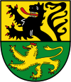
- Blazon : It shows in gold (yellow) above a green divided shield above a growing red armored lion, below a striding red crowned and armored, golden (yellow) lion.
- Explanation: The coat of arms shows the Jülich lion above and a striding lion (possibly the Geldrian lion) below and is modeled on the Nörvenich jury seal from 1556, which bears the inscription: SIGeL DER SCHEFFEN ZV NORVENICH.
Description of the banner: "The banner of the municipality of Nörvenich is yellow-green-yellow-green in a ratio of 1: 1: 1: 1 striped lengthways with the content of the municipality's coat of arms in the square banner head."
Infrastructure
traffic

Nörvenich can be reached via three motorway connections: via the Merzenich and Elsdorf junctions of federal motorway 4 , the Gymnich junction of federal motorway 61 and the Hürth-Knapsack exit of federal motorway 1 .
Local public transport is provided by the Rurtalbus in the Aachen transport association and the Cologne regional transport .
The long- distance cycle routes Kaiser-Route , which leads from Aachen to Paderborn , and the valley route run through Nörvenich- Hochkirchen .
The B 477 runs right through the community from north to south , running from Neuss to Tondorf and essentially following the route of an old Roman military road. This military route or trade route ran from Neuss via Zülpich to Trier ( Roman road Trier – Neuss ). It was 22 to 19 BC. Built by Marcus Vipsanius Agrippa .
The Heinzelmännchenweg from Roman times led from Oberbolheim via Girbelsrath and Distelrath above Mariaweiler via the Rur . A Roman burgus is said to have stood there around 200 AD above the tectonic crack on the Neffelbach .
According to the historian and archaeologist August Schoop, the Roman road junction at Neffelbach or Vicus "Norboniacum" is the largest Roman rubble field in the old district of Düren .
A higher-level route was the Höhenweg over the Eifel west of the Kyll . It ran from Trier via Bitburg , Prüm and Blankenheim to Zülpich and Neuss (today B 51 and B 477) with branches to Bonn , Wesseling and Cologne . This was the first Roman road in the northern Rhineland.
At Nörvenich the regional Roman road crossed Aachen - Mariaweiler - Nörvenich - Neffelbach crossing - Gymnich - Erft crossing "Germiniacum der Legio" - Cologne or Erftstadt - Wesseling and Bonn. Coming from Bonn, Caesar used this Roman road on the way to the Aduatuca camp .
At Thorr (Tibericum) the Via Belgica crosses Cologne – Maastricht .
See also
Rail transport

The main town has had no train station since 1968 . The reception building still exists and is privately owned as a residential building. Today's Dresdener Strasse is located in the area of the track system.
On October 6, 1908, the Düren circular railway started operating on the normal-gauge small railway line from Düren-Distelrath via Nörvenich to Zülpich . At that time Nörvenich only had 558 inhabitants. First, sugar beets were transported to the Düren sugar factory , on May 1, 1909, passenger traffic was also started. In 1928 the line between Düren and Nörvenich was electrified. From 1928 onwards, trams operated on the route , which was still licensed as a small train , and freight traffic continued to be served by steam locomotives. Passengers to Zülpich and Embken had to change trains in Nörvenich, as the route there was not electrified.
As early as 1905, the Bergheimer Kreisbahn had put the Benzelrath – Nörvenich railway into operation. The Bergheimer Kreisbahn including the Oberbolheimer line became the property of the Prussian State Railways in 1913 . The missing gap of just 1.7 kilometers between Oberbolheim and Nörvenich was finally closed on July 14, 1924 by the Düren circular path. At the same time, the number of station tracks was increased from three to five. The operation was carried out on a lease by the Deutsche Reichsbahn , in which the Prussian State Railways had merged after the First World War , on the short new construction section .
The trigger for the new line was the operation of the French occupying power in the course of the occupation of the Rhineland and the Ruhr area . The Cologne – Aachen railway line operated by the director was avoided as far as possible by the population as part of the passive resistance proclaimed by the Reich government . Passengers from Aachen to Cologne used the network from Aachen tram and Düren railway to Düren, from there on with the DKB to Nörvenich. The missing kilometers to Oberbolheim were covered on foot or in horse carts.
After 1945, the agricultural cooperative was connected with a siding and a beet loading track with a side ramp was added on the western side of Bundesstraße 477. It can still be seen under bushes across from the entrance to Nörvenich Air Base.
Between 1955 and 1958 the small railway line between Nörvenich and Bessenich near Zülpich was electrified. However, passenger traffic between Nörvenich and Zülpich ended without prior notice on January 31, 1960. On May 19, 1960, traffic on the Nörvenich – Kerpen line was also discontinued. On April 30, 1963 the remaining passenger traffic of the DKB to Düren was finally stopped. On June 30, 1968, the last freight train drove to Düren, followed by the shutdown and dismantling of the tracks.
Bördebahn

At the districts Binsfeld and Rommelsheim over the so-called börde railway, the former running Bundesbahn -distance Düren - Zülpich (- Euskirchen ), whose passenger traffic was shut down 1,983th In 2002, the then Düren Kreisbahn (DKB) bought the route from Düren to Zülpich (exclusively) for goods and local passenger transport from Deutsche Bahn . The route is operated by the Rurtalbahn GmbH , and since 2006 the route has been used seasonally by the Bördeexpress. Association tickets from VRS, AVV and the EuRegio-Ticket are recognized, bicycles and dogs are transported free of charge. For the 2014 State Garden Show , there was a three-hour service between Düren and Zülpich on Sundays and public holidays.
Air base, field airfield
police
On March 8, 2006, after many years, a police post with three police officers was set up in the central town, but in 2014 it was reduced to a district officer . He has his office in the town hall.
fire Department
In the community there is a fire fighting group of the Nörvenich volunteer fire brigade in all places except Eggersheim (dissolved around 1980), Hochkirchen (dissolved on March 1, 2005), Poll (dissolved around 1965) and Dorweiler (dissolved in 2012) . There are youth fire departments in Binsfeld, Eschweiler via Feld, Oberbolheim, Pingsheim and Rath .
Ambulance service
Nörvenich has a full-time rescue station , which is manned 24 hours a day with two paramedics and an ambulance from the Malteser Hilfsdienst (MHD). It is operated by the district of Düren as the provider of the rescue service. The rescue station looks after parts of the communities of Vettweiß and Nörvenich. After it was previously housed for rent in the building yard of the municipality in the industrial park, the new ambulance was inaugurated on December 9, 2009 at the corner of Kapellenstrasse and B477 in Eggersheim .
There is also a voluntary MHD station that has an ambulance .
technical aid organization
A voluntary local association of the technical relief organization is based in Nörvenich . The accommodation is right next to the former train station in Nörvenich. The OV has a technical train and a clearing department . The responsibility of the technical train is limited to the municipalities of Nörvenich, Vettweiß and Merzenich . The specialist group can also be used across municipal boundaries. The technical train can also be deployed outside the area of responsibility at the request of the responsible local association.
European Art Museum
In 1980 the Bodenstein family bought what was then Gymnich Castle, renovated it completely over many years, changed the name to Nörvenich Castle and presented the world's largest collection of works of art by the sculptor Arno Breker under the name Museum Europäische Kunst .
education
There are two primary schools in Nörvenich (Nörvenich for 215 pupils and Eschweiler above sea level for 125 pupils). Secondary schools are visited in Düren , Erftstadt and Zülpich .
In the field of adult education, in addition to the adult education center , private, church, communal and association-related initiatives are also active.
Several public halls and the Neffeltalhalle (built in 1988) with over 400 seats in the central town of Nörvenich are available as meeting places.
See also
societies
With around 70 clubs , Nörvenich offers opportunities for sporting, cultural and social activities. Rifle brotherhoods as well as civic associations and village communities ensure that old customs are maintained.
Kindergartens / day care centers
There are five day care centers and three kindergartens .
music
The famous guitar virtuoso Lajos Tar runs the private music school “Musica Humana” in Nörvenich Castle .
The rock group Can set up their studio in the castle from 1968 to 1969. Parts of their first album Monster Movie were recorded here.
The Kalscheuer siblings built organs in the 19th century .
Companies
Nörvenich is the headquarters of the Buir-Bliesheimer agricultural cooperative . The Nörvenich brewery, which no longer exists, was based in Nörvenich .
There is one bank branch each in Nörvenich
- Volksbank Rhein-Erft-Köln eG and the
- Sparkasse Düren .
- The Mariahilf Monastery, founded in 1933, is now operated by Caritas as a retirement home. Until 2017 the operator was the cath. Parish of St. Medardus.
Personalities
- Gerd Bandilla (* 1934), former municipal director
- Nicola Baumann (* 1985), fighter pilot and former astronaut candidate
- Jean Vincent de Crozals (1922–2009), French sculptor
- Isabel Hund (* 1962), chess master
- Franz Mohr (* 1927), author and piano technician
- Patricia Peill (* 1962), member of the 17th state parliament in North Rhine-Westphalia
- Herbert Pelzer (* 1956), author and local researcher
- Ulrich Rückriem (* 1938), sculptor
- Dieter Tappert (* 1972), known as "Paul Panzer", comedian
- Karl Heinz Türk (1926–2019), historian, local researcher, book author
- Hubert Türk (1925–2011), politician
- Karl Wendel (1912–1999), restaurateur
For other personalities see the respective districts.
Others
- The municipality of Nörvenich describes itself as a small municipality with a big heart .
- On August 25, 2020, the municipal administration put the first hydrogen- powered company car into operation.
literature
- Heinrich Heesel: The Counts of Nörvenich, Saffenberg and Mülbach in their area. History and local history association Nörvenich, published in 1986.
- Karl Heinz Türk: Binsfeld Castle in the municipality of Nörvenich near Düren. ISBN 3-88094-649-3 .
- Karl Heinz Türk: Twelve local chronicles for the districts of the community. Self-published with the municipal administration.
- Karl Heinz Türk: street names in the municipality of Nörvenich. Issue 1–4.
Web links
- Monuments in the municipality of Nörvenich
- Link catalog on the subject of Nörvenich at curlie.org (formerly DMOZ )
- Home -u. History Association of the Nörvenich community
Individual evidence
- ↑ Population of the municipalities of North Rhine-Westphalia on December 31, 2019 - update of the population based on the census of May 9, 2011. State Office for Information and Technology North Rhine-Westphalia (IT.NRW), accessed on June 17, 2020 . ( Help on this )
- ↑ ( page no longer available , search in web archives ) The future of lignite in selected areas, new opencast mines:…, Erp-Irresheim. Environmental Policy Research Center of the Free University of Berlin, April 2008, p. 1. (PDF; 147 kB; accessed on March 26, 2010)
- ↑ Flyer of the citizens' initiative “Citizens against Isweiler Feld” ( page no longer available , search in web archives ) Info: The link was automatically marked as defective. Please check the link according to the instructions and then remove this notice.
- ↑ Map of the lignite deposits and table of the possible opencast mines with details of the coal reserves from an investigation by Rheinbraun and the state government on which the decision for the Garzweiler II opencast mine (= Frimmersdorf West-West) is based in the 1980s ( Memento from June 19 2010 on WebCite ) PDF; 145 kB; 2 pp.
- ↑ https://www.noervenich.de/Startseiten-Artikel/20190809-Einwohnerzahlen.php
- ^ P. Lauster: Status symbols. Munich 1977.
- ↑ Engels: Landwehr in the Duchy of Jülich.
- ↑ M. Mausbach: Norboniacum - The story of Nörvenich. Nörvenich 1975.
- ^ Rumpel-Fischbach: materials. P. 622.
- ↑ Old land register in the Mauritius monastery in Cologne
- ↑ Norboniacum - The story of Nörvenich. Mathieu Mausbach, Nörvenich 1975, published by the municipality of Nörvenich and the history and local history association
- ^ Franz Cramer: Rhine. Place names from Roman and pre-Roman times. 1970, ISBN 3-253-02165-3 .
- ^ Wilhelm Kaspers: The place names of the Düren area. Düren 1949.
- ↑ Martin Bünermann: The communities of the first reorganization program in North Rhine-Westphalia . Deutscher Gemeindeverlag, Cologne 1970, p. 77 .
- ^ Federal Statistical Office (ed.): Historical municipality directory for the Federal Republic of Germany. Name, border and key number changes in municipalities, counties and administrative districts from May 27, 1970 to December 31, 1982 . W. Kohlhammer, Stuttgart / Mainz 1983, ISBN 3-17-003263-1 , p. 307 .
- ↑ https://noervenich50.wordpress.com
- ↑ Local elections on August 30, 2009 - Nörvenich election results. Retrieved June 20, 2014 .
- ↑ Timo Czech becomes head of the Nörvenich town hall. on: aachener-zeitung.de , September 13, 2015.
- ↑ Horst Wallraff: Nationalism in the Düren and Jülich districts. 2000, ISBN 3-927312-30-4 , p. 150.
- ↑ Main statute of the municipality of Nörvenich, § 2 paragraph 1 and 2. (PDF; 717 kB) (No longer available online.) Archived from the original on February 10, 2016 ; Retrieved December 21, 2012 . Info: The archive link was inserted automatically and has not yet been checked. Please check the original and archive link according to the instructions and then remove this notice.
- ↑ The art monuments of the Rhine Province. Volume 9: The art monuments of the Düren district. Published by Paul Clemen, Düsseldorf 1910, p. 1.
- ↑ New tariff regulations for the Bördeexpress 2010. (No longer available online.) IG Rurtalbahn eV, Bürgerbahn eV, archived from the original on June 11, 2009 ; Retrieved on September 7, 2010 : "Association tickets of the VRS and the AVV are recognized" Info: The archive link was inserted automatically and has not yet been checked. Please check the original and archive link according to the instructions and then remove this notice. .
- ↑ ( Page no longer available , search in web archives ) Keywords for reactivating the Eifel-Bördebahn by 2014. (PDF; 966 kB). IG Rurtalbahn eV, Bürgerbahn eV lighthouse project can be the 2014 State Garden Show in Zülpich.
- ↑ Eifelbahnen working group (ed.): 150 years of the Eifel-Bördebahn Düren – Zülpich – Euskirchen. Anniversary commemoration. Bad Münstereifel 2014.
- ↑ https://www.aachener-zeitung.de/lokales/dueren/mit-dem-wasserstoff-auto-durch-noervenich_aid-52974811
Aldenhoven | Düren | Heimbach | Huertgenwald | Inden | Jülich | Kreuzau | Langerwehe | Linnich | Merzenich | Nideggen | Niederzier | Nörvenich | Titz | Vettweiß
Binsfeld | Dorweiler | Eggersheim | Eschweiler over field | Frauwüllesheim with Isweiler | Hochkirchen | Mad home | Nörvenich | Oberbolheim | Pingsheim | Poll | Rath | Rommelsheim | Wissersheim