
Inden (Rhineland)
| coat of arms | Germany map | |
|---|---|---|
_COA.svg)
|
Coordinates: 50 ° 51 ' N , 6 ° 21' E |
|
| Basic data | ||
| State : | North Rhine-Westphalia | |
| Administrative region : | Cologne | |
| Circle : | Düren | |
| Height : | 106 m above sea level NHN | |
| Area : | 35.93 km 2 | |
| Residents: | 7397 (Dec. 31, 2019) | |
| Population density : | 206 inhabitants per km 2 | |
| Postal code : | 52459 | |
| Primaries : | 02465, 02423 | |
| License plate : | DN, JÜL, MON, SLE | |
| Community key : | 05 3 58 020 | |
| LOCODE : | DE IDE | |
| Community structure: | 7 districts | |
| Address of the municipal administration: |
Rathausstrasse 1 52459 Inden |
|
| Website : | ||
| Mayor : | Jörn Langefeld (independent) | |
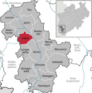
| Location of the municipality of Inden in the Düren district | ||
  |
||

Inden is a municipality in the district of Düren in North Rhine-Westphalia (Germany). It belonged to the Jülich district until January 1, 1972 .
geography
Highest point: Goltsteinkuppe 143.5 m above sea level. NHN
Lowest point: Viehöven 90 m above sea level. NHN
Geographical location
The area of the community forms the transition from the Zülpicher to the Jülich Börde .
Most of the community has been excavated since the late 1990s because of the Inden open-cast lignite mine by RWE Power AG (until 2003 Rheinbraun ). In the semicircle of the districts of Frenz / Lamersdorf / Lucherberg, the new town center with the name Inden / Altdorf was built. In 2005, the Pier Village began relocating. The new place Pier is in the municipality of Langerwehe. The Inde flows through the districts of Frenz and Lamersdorf . In 2005, at great expense, the Inde was diverted to new land around the advancing opencast mine.
As early as 2008, the recultivation of the remaining hole in 2030 was discussed because the Düren district had to create a new traffic concept. Originally, the remaining hole was to be filled with soil from the Hambach opencast mine using a conveyor belt . In September 2006 a concept for a recreational lake with an area of 1300 ha was presented to the Inden municipal council for the first time. This would mean that the remaining lake in 2035 would be about the same size as the Tegernsee . Remember , Lucherberg , Schophoven and Kirchberg would then be Seeranddörfer. With the name Indescher See there would already be a name for the rest of the lake. It is not the Indeland project .
Neighboring communities
The neighboring communities of Inden are, starting clockwise in the north: Jülich , Niederzier , Düren , Langerwehe , Eschweiler ( Aachen city region ) and Aldenhoven .
Community structure

The location

The town hall


Dredged localities
history
Around the birth of Christ, a village near Pommenich consisted of 18 buildings with four aisles and measuring 15 × 8 m. They each had one entrance on the long sides, rarely a third. Instead of the usual storage pits, there were numerous four-post storage facilities.
On January 1, 1972, the former communities of Altdorf, Frenz, Lamersdorf, Lucherberg, Pier and Schophoven were incorporated into Inden.
politics
Municipal council
The municipal council is the local people's representative body for the municipality of Inden. The citizens decide on the composition every five years. The last election took place on May 25, 2014.
mayor
The non-party attorney Jörn Langefeld has been Mayor of Inden since 2015. He will not stand for re-election in the local elections on September 13, 2020.
badges and flags

Coat of arms of the municipality of Inden

Flag of the municipality of Inden

The municipality of Inden was granted the right to use a coat of arms and a flag in a certificate issued by the district president in Cologne on May 6, 1974.
Blazon : “Under a silver shield head in blue a church in confused colors in frontal view with obtuse-angled roof, on it a beamed roof rider with a six-sided pointed helmet reaching into the shield head , both gable ends and the roof rider each equipped with a paw cross , a Gothic shield framed in the open column-framed portal with a red-armored and red-tongued black lion in gold. "
Description of the flag: "Blue-white-blue in a ratio of 1: 4: 1 striped lengthways, with the coat of arms of the municipality in the middle."
Attractions
- Gut Lützeler in Inden / Altdorf
- Gut Müllenark in Schophoven
- Inden opencast mine viewpoint
- House Pesch in Pier
- Indenlow
- Catholic parish church St. Nikolaus Frenz
- Catholic parish church St. Cornelius Lamersdorf
- Catholic parish church of St. Clemens and St. Pankratius Inden / Altdorf
Buildings
Visible from afar, the Weisweiler power plant in Eschweiler points the way to Inden, which is right on the edge of the community. The Lützeler and Merödgen estate in Inden / Altdorf and the Müllenark estate in Schophoven are listed as old manors . Since 2009 Inden has had a new landmark, the Indemann , a 36 m high observation tower on the Goltsteinkuppe, which offers a view of the Inden opencast mine and the surrounding area.
On December 6, 2011, the largest solar park in North Rhine-Westphalia was inaugurated on the former garbage dump of the municipality of Inden near the Weisweiler power station .
Sports
Inden / Altdorf has a soccer club, a shooting club, a tennis club and a handball club. For youth sports, the municipality of Inden has also financed a skater track near the secondary school.
museum
See Local History Museum Inden in Lucherberg
Economy and Infrastructure
traffic
Inden is located on the partially disused Bundesstrasse 56 and on the Bundesautobahn 4 . The next entrance onto the motorway is Weisweiler / Eschweiler-Ost .
Bus lines connect Inden in all directions with Kirchberg, Jülich, Krauthausen, Niederzier, Merken, Düren, Luchem, Langerwehe, Weisweiler and Eschweiler. All lines can be used with the tariff of the Aachen transport association .
From 1873 to 1983 Inden had a rail link with its own train station on the Stolberg - Jülich line . Its station building was destroyed by air raids in the Second World War and was not rebuilt, but replaced by a small shelter. The line between Stolberg and Jülich was closed for passenger traffic in 1983 and dismantled between Frenz and Jülich. The remaining section between Weisweiler and Frenz in the municipality of Inden is no longer used for local public transport, but is operated exclusively for freight transport. Lime flour trains run here for the Weisweiler coal-fired power station. Today the area of the Inden train station and the corresponding route have been excavated, including the old location.
From 1927 to 1965 Inden was also the end point of the Düren - Inden railway line . This meter- gauge electric overland tram from Düren via Merken and Pier to Inden was operated by Dürener Eisenbahn AG . The line from Düren had already been run as far as the Pier district of Inden in 1908, initially as a steam tram.
Personalities
- Jakob Gerhard Engels (1826–1897), Protestant pastor and pietist
- Wilhelm Johnen (1902–1980), politician (CDU), President of the State Parliament of North Rhine-Westphalia
- Erich Pelzer (* 1950), historian and university professor
- Wolfgang Dietrich (1951–2016), politician (CDU), member of the state parliament of North Rhine-Westphalia
Individual evidence
- ↑ Population of the municipalities of North Rhine-Westphalia on December 31, 2019 - update of the population based on the census of May 9, 2011. State Office for Information and Technology North Rhine-Westphalia (IT.NRW), accessed on June 17, 2020 . ( Help on this )
- ↑ Archeology in Germany 04/2016, p. 48 f.
- ^ Federal Statistical Office (ed.): Historical municipality directory for the Federal Republic of Germany. Name, border and key number changes in municipalities, counties and administrative districts from May 27, 1970 to December 31, 1982 . W. Kohlhammer, Stuttgart / Mainz 1983, ISBN 3-17-003263-1 , p. 306 .
- ↑ Inden municipality. European / Local elections 2014. May 25, 2014, accessed on November 4, 2014 .
- ↑ https://www.aachener-zeitung.de/nrw-region/strafbefehl-gegen-den-indener-buergermeister_aid-51951401?commentId=e1c0e600-07f4-452c-9f2e-99f737fab59a
- ↑ Main statute of the municipality of Inden, § 2 paragraph 1 and 2. (PDF; 46 kB) Retrieved on December 20, 2012 .
- ↑ Inden solar park will be the largest solar power plant in North Rhine-Westphalia. Retrieved April 4, 2013 .
Web links
Aldenhoven | Düren | Heimbach | Huertgenwald | Inden | Jülich | Kreuzau | Langerwehe | Linnich | Merzenich | Nideggen | Niederzier | Nörvenich | Titz | Vettweiß
Existing districts:
Frenz |
Inden / Altdorf |
Lamersdorf |
Lucherberg |
Schophoven (with the hamlet Viehöven )
Former districts:
Inden |
Altdorf |
Geuenich |
Pier (with Pommenich and Vilvenich )