
Titz
| coat of arms | Germany map | |
|---|---|---|

|
Coordinates: 51 ° 0 ' N , 6 ° 25' E |
|
| Basic data | ||
| State : | North Rhine-Westphalia | |
| Administrative region : | Cologne | |
| Circle : | Düren | |
| Height : | 95 m above sea level NHN | |
| Area : | 68.51 km 2 | |
| Residents: | 8455 (Dec. 31, 2019) | |
| Population density : | 123 inhabitants per km 2 | |
| Postal code : | 52445 | |
| Primaries : | 02463, 02164 | |
| License plate : | DN, JÜL, MON, SLE | |
| Community key : | 05 3 58 056 | |
| LOCODE : | DE TIZ | |
| Community structure: | 16 districts | |
| Address of the municipal administration: |
Landstrasse 4 52445 Titz |
|
| Website : | ||
| Mayor : | Jürgen Frantzen ( CDU ) | |
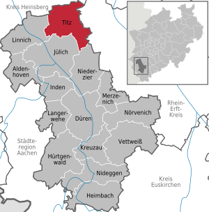
| Location of the municipality of Titz in the Düren district | ||
  |
||


Titz is a rural municipality in the north of the Düren district ( North Rhine-Westphalia ).
geography
The municipality of Titz is located in the Jülich Börde . In the south is the Sophienhöhe . East and northeast of the community is the Garzweiler open-cast lignite mine .
Waters
The Malefinkbach rises near Titz and flows to the Rur .
| Erkelenz | ||||||
| Juchen | ||||||
| Linnich |
.svg)
|
Bedburg | ||||
| Jülich | Elsdorf | |||||
| Niederzier |
Neighboring communities
- District of Düren : City of Jülich , City of Linnich , Niederzier municipality
- District of Heinsberg : City of Erkelenz
- Rhein-Kreis Neuss : City of Jüchen
- Rhein-Erft district : City of Bedburg , City of Elsdorf
Community structure
Since the regional reform in 1975, the municipality of Titz has been made up of 16 districts:
- Ameln
- Bettenhoven
- Gevelsdorf
- Hasselsweiler
- Hells
- Hompesch
- Jackerath
- Kalrath
- Müntz
- Mouths
- Opherta
- Ralshoven
- Rödingen
- Sevenich
- game
- Titz (eponymous capital of the municipality; mayor: Norbert Schiffer)
The town of Titz itself has 2,539 inhabitants (as of December 31, 2017).
history
Incorporations
On July 1, 1969, the former communities of Gevelsdorf , Hasselsweiler and Müntz were incorporated. On January 1, 1972, Rödingen was added. From the dissolved community of Garzweiler , Titz was assigned 4.80 km² with 763 inhabitants at the time.
politics
Municipal council
The municipal council is the local people's representative body for the municipality of Titz. The citizens decide on the composition every five years. The last election took place on May 25, 2014.
mayor
Jürgen Frantzen (CDU) has been the mayor of the community since October 21, 2009; in the last local election on May 25, 2014, he was confirmed in office with a result of 59.6 percent of the votes.
Previous mayors (since the municipal reorganization ):
- 1969 to 1994: Wilhelm Lieven (born September 2, 1934; † September 16, 2014), CDU
- 1994 to 1999: Hans-Jürgen Herrmann (born January 9, 1947), SPD
- 1999 to 2009: Josef Nüßer (born May 16, 1953), CDU
- since October 2009: Jürgen Frantzen (born December 16, 1962), CDU
Coat of arms and banner
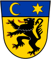
Coat of arms of the former Titz office

Banner of the municipality of Titz

The municipality of Titz has been granted the right to use a coat of arms.
|
|
Blazon : “In gold (yellow) a red armored and tongued black lion, accompanied (heraldically) on the right by three, on the left by two six-pointed blue stars; At the top left there is a waning blue moon. " |
| Justification of the coat of arms: The coat of arms was taken over by the Titz Office in 1972 and comes from a jury's seal from 1343. It shows the black lion of the Duchy of Jülich, to which Titz used to belong. The stars stand for the number of former parishes, the meaning of the moon is unclear. |
The municipality has also been given the right to fly a flag.
- Description of the banner:
- "Blue-yellow in a ratio of 1: 1 striped lengthways with the municipal coat of arms in the upper half."
Culture and sights
Buildings

- The Katharina Chapel in Höllen has remains of medieval wall paintings .
- The Düppelsmühle in Titz, a post mill from the 16th century. Formerly a windmill in Efferen , set up in Titz in 1830.
- The post mill from Spiel has been in the Rheinisches Freilichtmuseum Kommern since 1959 .
Catholic Church
synagogue
One of the few surviving regional synagogues in the Rhineland exists in Rödingen. The LVR-Kulturhaus Landsynagoge Rödingen shows Jewish life in the Rhineland in a permanent exhibition and offers numerous events. There are Jewish cemeteries in Rödingen and Müntz.
Evangelical community center

The Protestant parish of Kirchherten maintains a community center in Titz, which is used for church services, women's groups, church lessons and a Bible study group. The multifunctional building has two colored glass windows by the Alsdorf glass artist Ludwig Schaffrath .
Matron stones
In 1785 nine matron stones from the Roman settlement phase were found between Rödingen and Höllen . One stone is still preserved. The original is in the Reiss Museum Mannheim , a duplicate each in the foyer of the Titz town hall and in the village of Rödingen on the corner of Hohe Straße / Platz.
Regular events
- Carnival parade in Titz on Tulip Sunday . The organizer is the Titzer Karneval eV interest group
- Bike races and Father's Day party . The organizer is SV 1919 Rödingen-Höllen eV
- Shooting festival in Titz on the first Sunday after September 8th. The organizer is the St. Antonius-Schützenbruderschaft Titz 1442 eV
- Shooting festival in Rödingen every year on the 3rd Sunday in July. The organizer is the St. Sebastianus Schützenbruderschaft Rödingen eV
Way of St. James
A pilgrimage route of the St. James pilgrims in the Rhineland leads through the municipality of Titz via Mündt, Opherten, Titz, Meerhof and Spiel . It is route 9 that leads from Dortmund to Aachen. The stops along the way are the neighboring villages of Kaster and Jülich.
Economy and Infrastructure
Agriculture
In 2005, 87% of the municipal area was used for agriculture . This makes the municipality of Titz the municipality with the largest share of agricultural land in North Rhine-Westphalia. As a result, Titz, with a forest share of less than 4%, is also the municipality with the lowest forest share in North Rhine-Westphalia.
traffic
The highway A 44 passes through the town and forms with the highway A 61 at Jackerath the same junction .

Titz used to have a stop on the Mönchengladbach – Stolberg railway line . Since the railway line passed east of the town of Titz at a considerable distance, the Titzer stopping point was at the extreme northeast end on the road towards Jackerath. Although Titz is significantly larger than Ameln, Titz only had an insignificant stopping point. However, this consisted of two platforms, which are to this day - now overgrown - north and south of the highway.
Titz is integrated into the cycle path network of North Rhine-Westphalia . Cycle tourism experts can orientate themselves on the system of junctions . The Radwanderweg Wasserburg-Route leads through the community.
State Office for Road Construction
The Landesbetrieb Straßenbau, Krefeld branch maintains the Titz motorway maintenance facility near the motorway triangle.
LVR Office for Land Monument Preservation in the Rhineland
The LVR Office for Land Monument Preservation in the Rhineland , an office of the Rhineland Regional Council (LVR), maintains a branch in Titz-Höllen. This is responsible for the archaeological excavations in the lignite opencast mines Garzweiler , Hambach and Inden . The branch can be visited on the annual Archeology Day .
Personalities
- Ferdinand Hillebrand (1890–1972), mayor of Zell (Mosel) and Cochem, born in Titz.
- Josef Neumann (1856–1912), founder of the Kreuzbund abstinence association , 1901–1909 pastor in Opherten.
- Wilhelm W. Hamacher (1930–2004), municipal official and local researcher, born and raised in Titz
- Ferdinand Esser (* 1936), director of the Rhineland Regional Council (LVR) 1995–2001, born in Jülich.
- Petra Hammesfahr (* 1951), writer and screenwriter, born in Titz.
- Anna Müller (Titz) (* 1998), German potato queen
literature
- Hermann-Josef Paulißen (arr.): The population of Titz in 1812. On the structure of people in a rural Rhenish community (= Forum Jülich history . Volume 23 ). Jülich 1997, ISBN 3-932903-03-X .
- Monika Grübel: Synagogue and ruler's house in Titz-Rödingen. Past - present - future . Rheinland-Verlage, Cologne 2001, ISBN 3-7927-1838-3 .
Web links
- Homepage of the municipality of Titz
- Information on the local history of the Titz History Association
- Monuments in the municipality of Titz
Individual evidence
- ↑ Population of the municipalities of North Rhine-Westphalia on December 31, 2019 - update of the population based on the census of May 9, 2011. State Office for Information and Technology North Rhine-Westphalia (IT.NRW), accessed on June 17, 2020 . ( Help on this )
- ↑ Martin Bünermann: The communities of the first reorganization program in North Rhine-Westphalia . Deutscher Gemeindeverlag, Cologne 1970, p. 99 .
- ^ Federal Statistical Office (ed.): Historical municipality directory for the Federal Republic of Germany. Name, border and key number changes in municipalities, counties and administrative districts from May 27, 1970 to December 31, 1982 . W. Kohlhammer, Stuttgart / Mainz 1983, ISBN 3-17-003263-1 , p. 294 .
- ^ Titz parish. Local elections 2009. August 30, 2009, accessed November 6, 2014 .
- ^ Titz parish. European / Local elections 2014. May 25, 2014, accessed on November 4, 2014 .
- ↑ Certificate from the District President in Cologne, Az. -31.21.04- dated December 11, 1972.
- ↑ Main statute of the municipality of Titz, § 2 paragraph 1 and 2. (PDF) Retrieved on December 20, 2012 .
- ↑ Certificate from the District President in Cologne, Az. -31.21.04- dated December 11, 1972.
- ↑ Rainer Draaf: The historical Efferener windmill. Hürther Contributions to History, Culture and Regional Studies 78, 2008, pp. 39–48.
- ↑ Schaffrath glass window in the Ev. Community center Titz ( page no longer available , search in web archives ) Info: The link was automatically marked as defective. Please check the link according to the instructions and then remove this notice.
- ↑ Heimat- und Geschichtsverein Titz - honorary memberships
- ↑ Heimat- und Geschichtsverein Titz - Award of honorary membership
- ↑ http://epaper.supersonntag.de/2.0/#/read/ssv-m1/20190721?page=0&article=62933271
Aldenhoven | Düren | Heimbach | Huertgenwald | Inden | Jülich | Kreuzau | Langerwehe | Linnich | Merzenich | Nideggen | Niederzier | Nörvenich | Titz | Vettweiß