
Malefinkbach
| Malefinkbach | ||
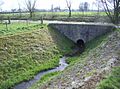
 Stream bed in Hasselsweiler |
||
| Data | ||
| Water code | DE : 28254 | |
| location | Germany | |
| River system | Rhine | |
| Drain over | Rur → Maas → Hollands Diep → North Sea | |
| River basin district | Meuse | |
| source | north of Opherten as Kertzempfuhl 51 ° 1 '2 " N , 6 ° 26' 37" O |
|
| Source height | 109 m above sea level NN | |
| muzzle | north of Rurich in the Rur coordinates: 51 ° 1 ′ 28 " N , 6 ° 14 ′ 59" E 51 ° 1 ′ 28 " N , 6 ° 14 ′ 59" E |
|
| Mouth height | 52 m above sea level NN | |
| Height difference | 57 m | |
| Bottom slope | 2.6 ‰ | |
| length | 21.8 km | |
| Catchment area | 71.895 km² | |
| Drain at the mouth |
MNQ MQ |
60.1 l / s 292.48 l / s |
The Malefinkbach or "the Malefink" has its source in the Jülich region about 100 m above sea level near Opherten and Titz . Here is the watershed between Rur and Erft . The water flows into the Rur at about 52.5 m above sea level north of Rurich at Gut Gansbroich . The Malefinkbach has a catchment area of 71.5 km² and a length of 21.8 km.
geography
course
The course is initially from north-east to south-west. Coming from Opherten and Titz , the stream flows past the Meerhof farm through Hasselsweiler . From here its course begins in a valley past Müntz and Hompesch to Boslar . The Malefinkbach now emerges from the valley and flows behind Tetz into the flat, meadow-rich Rur landscape. The brook now lies parallel to the Rur; it flows northwards past Linnich and Körrenzig to Rurich Castle, past Rurich and joins the Rur north of the village.
Tributaries
- Maargraben ( right ), 1.7 km
- Main ditch in the Rurbruch ( right ), 2.5 km
- Suitcaseer Graben ( right ), 1.8 miles
- Lövenicher Graben ( right ), 4.2 km
Hydraulic engineering
In 1965 flood damage occurred in the upper reaches , so the stream was rebuilt and given a new profile.
Renaturation measures were later carried out in the Rurauen below Tetz .
Water flow
Due to the pumps from the nearby brown coal opencast mine , the stream has no continuous water flow and no contact with groundwater . It received an inflow from the now closed sewage treatment plant in Hompesch. In the lower reaches, in the Rurauen, the original groundwater contact no longer exists, since drainage measures intervene here . There is also strong seepage in loose subsoil.
The Malefinkbach would have dried up completely in the lower course of the stream today if the opencast mine operator, the Rheinbraun company , now RWE Power AG , did not continuously feed water into the area of the Rur bridge in Körrenzig.
Water law
The Rurich Castle is a still water rights to the Malefinkbach.

Malefinkbachtal east of Boslar

Pollard willows by the stream near Körrenzig
Estuary into the Rur


