
Rur


The Rur ( French and Dutch Roer ) is a 164.5 km long, southeast and orographically right tributary of the Meuse in Belgium , Germany and the Netherlands ; about 80 percent of the river stretch is on German territory.
Surname
The name of the river has been written without an "h" since around 1900 to distinguish it from the Ruhr flowing to the Rhine ; to differentiate one also speaks of the Eifel-Rur . The old spelling still appears in place names such as Erkensruhr and Einruhr . The river Roer is written in Dutch and French (but as pronounced in German), in Belgium ( Wallonia ) also Rour or Roule .
geography
course
Top run in Belgium
The Rur rises in the Belgian province of Liège in the High Fens . Its source is located in the natural park Venn-Eifel about 900 meters north-east of the near Sourbrodt located Botrange ( 694.24 m OP ; highest elevation of Belgium) to around 660 m OP height.
Initially, the Rur flows mainly in an easterly direction through the uninhabited High Fens. After 10.4 km of the river, it reaches the Belgian-German border between the Bütgenbach district of Küchelscheid (Belgium) and the Monschau district of Kalterherberg (Germany).
Long middle course in North Rhine-Westphalia
The Rur in North Rhine-Westphalia then runs a short distance north in the Aachen city region . It crosses the Eifel, mostly steeply in a narrow, winding valley, and passes a little southeast of the Monschau district of Mützenich, which lies on a plateau . Even before the Monschau core town, through which it flows, the Rur turns to the east and passes the Monschau district of Widdau , which is located above the valley . Then it passes Hammer on the left bank and flows through Dedenborn , which is mostly inside a long north loop; both are Simmerath districts.
Then the Rur flows into the north-northeast facing Obersee of the Rur reservoir , also called Rursee , before the Simmerath district of Einruhr ; the latter is the second largest reservoir in Germany by volume . The Obersee and with it the Rur receives an inflow from the Urft , its natural right inflow, via the overflow of the Urfttalsperre . Immediately below the Obersee, the Rur runs between the village of Rurberg, which belongs to Simmerath, and the Heimbach district of Hasenfeld through the Rurstausee, in which it changes to the district of Düren and also passes the Nideggen district of Schmidt , which is again on a plateau on the left . It then flows through the reservoir of the Heimbach reservoir , which receives inflow from the Urft reservoir in the south and thus from the Urft through the Kermeter tunnel , which tunnels under the Eifel region Kermeter . The Eifel National Park , which is divided into a southern and northern part by the Rurstausee , meets all three reservoirs .
Below the reservoir, the Rur flows from about the core town of Heimbach east of the national park towards the north. It passes or flows through the localities of Hausen and Blens in the Heimbach urban area and, in the following, from Nideggen, the villages of Abenden , Hetzingen and Brück , over which the Nideggen core town spreads on the Eifel plateau, partly on a spur. The Hürtgenwald district of Zerkall is located in the wedge of the valley at the mouth of the Kall , which then tapers from the left .
The Rur then runs through the Obermaubach reservoir on the lower left bank of which the town of Obermaubach is located, and it passes or flows through Schlagstein , Untermaubach , Üdingen and Winden ; they all belong to Kreuzau , whose core town of the same name the river then passes on the right bank. Then it moves in the Düren city area through Lendersdorf and past Rölsdorf and flows through the Düren core city, from where it turns more and more to the northwest. Below the city center she passes the Düren districts of Mariaweiler , Birkesdorf , Hoven and, after crossing under the federal motorway 4 , also Merken .
Opposite Merken, the Rur flows past the Huchem-Stammeln east of the river , then Selhausen and Krauthausen ; they all belong to Niederzier . Then it passes the Inden district of Schophoven , which is a bit away from the river .
In the Jülich urban area are close to the river Selgersdorf , Altenburg and Kirchberg , where the Inde flows into. Then the Rur crosses the Jülich core town, which is mainly on the right, and after crossing under the federal motorway 44 , passes the districts of Koslar , Broich and Barmen . In its wide floodplain, which is now only slightly dug into the surrounding area, some mill ditches, called mill ponds , branch off from here , which once supplied water to water mills or tanneries .
A little to the east off the Rur is the Linnich district of Tetz . The river then passes in the Linnich area Floßdorf and Rurdorf and then flows through the town of Linnich, which is in the core on the left, and then past the district of Körrenzig ; The Rur was renatured on this last section of the corridor .
According to this, the Rur runs in the district of Heinsberg in the urban area of Hückelhoven past the villages of Rurich , Brachelen , Hilfarth and Doverack as well as the Hückelhovener core town; then it passes the districts of Millich and, after crossing under the federal motorway 46 , Ratheim with Krickelberg and Garsbeck . Opposite Ratheim to the west of the Rur in the urban area of Heinsberg are the villages of Oberbruch and Unterbruch . Below Garsbeck, the river passes the Wassenberg district of Luchtenberg and then the Wassenberg core town. Then he passes the Heinsberg residential areas and districts of Brehm , Hochbrück , after which the Wurm , which has been running parallel to the left for a long time, joins Kempen ; Karken then on the same side is a little further away from the river, opposite it, east of the Rur, are the Wassenberg villages of Ophoven , Steinkirchen and Effeld .
Lower course and estuary in the Netherlands
The Rur then crosses the border with the Dutch province of Limburg after a 132.3 km stretch in North Rhine-Westphalia , where it passes the Roerdalener districts and locations of Vlodrop , Herkenbosch , Sint Odiliënberg , Melick and Lerop . It then flows in the urban area of Roermond past the locations Kitskensberg , De Kemp and Donderberg . West of De Kemp of 2.5 km long Roertunnels passes under the flow close to the West Portal a piece of A 73 .
After the last 21.8 km in Dutch territory, the Rur flows into two branches of the Meuse between the Roerond location Roer and the city center at about 17 m NAP height .
The mouth of the Rur in Roermond is navigable. There is u. a. at the old Looskade (loading quay) for boats up to 8 mtr. Length of a "pier" laid out on both sides of the Rur z. B. for a visit to Roermond, but staying overnight is not allowed. The Rur is here max. 30 m wide, but often occupied by boats on both sides. The length of the boat had to be limited because otherwise turning in the narrow and flowing river arm of longer boats would be impossible or only possible with considerable danger.
On the 164.5 km long course from the source, which is about 643 m higher up to the mouth, the Rur has an average bed gradient of about 3.9 ‰.
Until 1342 the Meuse ran seven kilometers further west near Roermond. It was moved from 1338 to 1342 towards the city, on the southwestern edge of which the mouth is today.
Muzzle of both arms of the Rurm (both in Roermond):
Catchment area, tributaries and mill ponds
The catchment area of the Rur is 2360.88 km² . The most important tributaries and mill ditches ( mill ponds ) of the Rur are the Urft , Inde and Wurm . The tributaries and mill ponds of the Rur include (viewed downstream):
- Small Rur / Petite Rour
- Breitenbach in Küchelscheid
- Schwarzbach in Küchelscheid
- Perlenbach (sometimes also Perlbach, in East Belgium Schwalmbach)
- Laufenbach in Monschau
- Belgenbach near Widdau (from left)
- Brommersbach near Hammer
- Riffelsbach near Hammer
- Erkensruhr at Einruhr
- Urft in the Obersee of the Rurtalsperre near Rurberg (from right)
- Mühlbach (Rur) in the evenings
- Kall at Zerkall
- Rinnebach in Obermaubach
- Windener mill pond
- Kreuzau mill pond
- Lendersdorf mill pond
- Düren mill pond
- Inde near Kirchberg (from left)
- Ellebach in Jülich
- Altdorfer - Kirchberger - Koslarer mill pond near Floßdorf
- Merzbach near Linnich (from left)
- Malefinkbach near Rurich
- Baaler Bach (I) near Rittergut Grittern / Hückelhoven ( called Nysterbach near Kleinbouslar in the upper reaches ) (from right)
- Golkrath Bach near Millich
- Erlenbach - Linnicher mill pond - Teichbach near Porselen-Bleckden
- Floßbach, also Gerderather Bach
- On old maps (e.g. the map of the district of Erkelenz 1820) it can be seen that the Floßbach, which came from Gerderath towards the Rur in a south-westerly direction, changed its course to the north-west after Ratheim and parallel to the Rur for about 8 km passed. It flowed into the river near the Dutch border between Ophoven and Effeld. Its old name Bohlbach may have led to the (misleading) current name Baalerbach. With the landscaping ( land consolidation ) from the end of the 1950s to the mid-1960s and the subsequent river straightening, the course of the streams was also changed:
- the Floßbach, now also called Ratheimer Mühlenbach, flows into the Rur near Ratheim near the Adolfo lake and serves as a receiving water for the Ratheim sewage treatment plant
- its former tributary, the Pützbach, “crosses” today's Floßbach, then runs in its former bed and flows into the Rur at Ratheim-Garsbeck
- its former tributary, today's "Baalerbach" (II), which is called "Myhlerbach" above Orsbeck, flows into the Rur at Gut Wylack / Wassenberg
- Wurm near Kempen (from left)
- Mühlenteich Junge Wurm (Lieker Bach) near Karken, remnants of the former Mühlenbach, which was branched off from the Wurm from Randerath . The young worm is documented as early as the 8th century AD.
- Schaagbach near Vlodrop / Netherlands (called "Birgeler Bach" above Effeld)
- Rothenbach near Vlodrop / Netherlands
- Boschbeek near Herkenbosch / Netherlands
The mill ponds located on the Rur are not ponds in the ordinary sense of the word, i.e. stagnant bodies of water, but flowing waters fed by the Rur, which were artificially created between the 15th and 18th centuries in order to be able to live in the Rur valley - also away from the river and its tributaries - to be able to operate a variety of watermills .
Jülich mill pond (at a discount)
Linnich weir ( ⊙ )


Dams

The dams, which are used for flood protection and water enrichment and with the water collected in their reservoirs, for drinking water supply and electricity generation, on the Rur and its tributaries are:
- Dreilägerbachtalsperre , drained via Dreilägerbach, Vicht and Inde into the Rur
- Kalltalsperre , drained over the Kall into the Rur
- Oleftalsperre , drained via the Olef, Urft, Urfttalsperre into the Rur
- Perlenbachtalsperre drains into the Rur via Perlenbach
- Rurtalsperre with Obersee and Vorsperre Eiserbach at the Rur
- Heimbach dam , on the Rur
- Obermaubach reservoir , on the Rur
- Urfttalsperre , usually drains through the Kermeter tunnel at the Heimbach dam into the Rur and in the event of a flood over the dam overflow into the Obersee of the Ruralsperre
- Wehebach dam , drains via Wehebach and Inde into the Rur
cities and communes
Cities and municipalities on the Rur are:
Hydrology
Numerous gauges are operated on the Rur, for example at Altenburg . At the Stah gauge near Kempen , not far from the Dutch border and after the Wurm flows into it, a gauge will be operated on the German side for the last time. There the mean water level (MW) is 0.52 m and the mean high water level (MHW) is 2.10 m.
The Rur contributes around 10% to the discharge of the Meuse near Roermond with an average of around 26 m³ / s.
If the Meuse floods, its inner-city estuary in Roermond can be separated from the Meuse with two flood sluices. Then the entire Rurwasser flows over the second estuary, the Hambeek. The inner-city Rurarm is used as a guest harbor (Passantenhaven) for sport shipping.
Energy generation
The water from the Rur is also used to generate energy. The turbines in the Schwammenauel, Heimbach, Obermaubach and Roermond (ECI Centrale) power plants are used to generate electricity.
Water law responsibilities
In terms of water law, the Eifel-Rur Water Association (WVER) is responsible for the Rur on the German side . The European Union (EU) is funding flood protection and renaturation projects of the WVER on Indian and Rurau meadows under the project name RIPARIA. In the areas of Körrenzig , Millich and Ratheim , an old arm was integrated and natural retention areas were created again.
The Waterschap Roer en Overmaas is responsible on Dutch territory .
Nature reserves
Large areas of the Rur and the Rur Valley to Linnich are designated as nature reserves . These are the Upper Rurtal with the rock formations of the Ehrensteinley , the Middle Rurtal with the rock formations of the Perdsley and Wiselsley , Rurtal with the rock formations of the Uhusley red sandstone rocks in the Rur valley between Heimbach and Kreuzau , Rur in Jülich , Rurmäander between Floßdorf and Broich , red sandstone rocks near Blens and Rurtal from evenings to the area where the Rur flows into the Obermaubach reservoir . Some of these areas are designated as fauna-flora-habitat areas. There are problems with red sandstone rocks used as climbing rocks in the Rur valley or in side valleys, where the habitat in the entry area of climbing routes or "sweeping out" of loose scree or rocky vegetation is degraded or lost. In particular, the occurrence of the wall lizard is worried and egg-laying places at the field feet are destroyed.
Buildings
Weirs
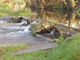
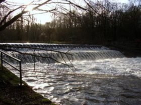
The weirs on the Rur include (viewed downstream):
- Winden weir, between Winden and Kreuzau
- Kreuzau weir, in Kreuzau
- Rurdorfer weir, between Rurdorf and Linnich
bridges
An outstanding bridge structure over the Rur is the railway bridge in Düren, the three-belt bridge .
Castles, palaces and churches
The castles, palaces and churches on the Rur include:
- Monschau Castle
- Hengebach Castle (Heimbach Castle)
- Nideggen Castle
- Untermaubach Castle
- Burgau Castle
- Basilica in Sint Odiliënberg
history

The name of the river goddess Rura is already known from Roman times . An altar for this goddess was known near Roermond. The early medieval geographer of Ravenna also mentions the river name Rura. Up until around 1570 there was a shipping operation with small ships on the Rur between Roermond and Jülich. Efforts were made to keep the Rur navigable as far as Jülich. After all, land transport turns out to be more economical. But there was still a rafting business until the middle of the 16th century .
Department de la Roer
From 1798 to 1814, the Département de la Roer (Rur department) existed under French occupation . Its capital was Aachen . The arrondissements were Aix-la-Chapelle , Clèves , Crévelt and Cologne (today Aachen, Kleve, Krefeld and Cologne). The cantons in the Rur area were Heinsberg , Linnich, Jülich , Düren , Froitzheim (today Vettweiß ), Gemünd and Montjoie ( Monschau ).
Second World War
In the Second World War , the Rur formed the front line at the end of 1944 / beginning of 1945; both the German and the Allies referred to it as the Rur front . In November 1944 there was a tank battle near Linnich, of which a memorial stone on the Hubertus Cross commemorates.


As a defensive measure against the advancing Allies, the Kermeter pressure tunnel of the Urft dam and the closures of the bottom drainage tunnel of the Schwammenauel dam ( Rursee ) were blown up on February 10, 1945 . Operation Grenade began on February 22nd . On February 23, the 102nd US Infantry Division was able to cross the Rur between Linnich and Rurdorf . Already at the beginning of December 1944 (the American war diary mentions December 1st) Linnich had taken it after a hard fight. Harsh winter weather and poor visibility prevented the Western Allies from taking advantage of their air superiority for weeks .
The second transition took place on February 25 at Hilfarth, followed by the capture of Hückelhoven by the 134th US Infantry Regiment . From there, the Americans marched further north (e.g. Mönchengladbach) in order to unite with Allied units further north.
In March 1943, a small camp for Soviet prisoners of war was built near the Bosfagne Bridge over the Rur near Sourbrodt . It was a branch of the Elsenborn camp, which had held Soviet prisoners since 1941. The prisoners were used for forest work and haymaking. When the Allied troops approached at the end of September 1944, the prisoners were transferred to the Elsenborn camp and from there to Germany.
The first memorial cross erected in 1963 by the Amis de la Fagne stands today at the front of the small memorial. In 1992 it was replaced by a Russian Orthodox cross at the former storage site.
tourism

The Rur is suitable for canoe tours. At Monschau you can find white water in spring, and between Düren and Linnich (restrictions apply to this section) and Linnich and the Dutch border you can go canoeing all year round .
The Rurufer cycle path runs alongside the river between Heimbach am Rursee and the Dutch border . Since the Rur Valley Railway also transports bicycles on the Jülich - Düren and Düren - Heimbach lines , the route from Heimbach to Linnich is particularly interesting because you don't have to cycle back.
Non-cyclists can experience the Rur Valley between Linnich, Düren and Heimbach with the Rur Valley Railway.
In Jülich, the Rur feeds the trenches of the restored bridgehead from the Napoleonic era in the Brückenkopf-Park recreation area .
The water information center is located in Heimbach .

Water tourists can moor in the Rurhafen of Roermond (pedestrian port).
See also
literature
- Günter Marenberg: The Rur . From the source to the mouth. Meyer and Meyer, Aachen 1994, ISBN 3-89124-224-7 .
- The Rur rises in the rhubarb garden. Schmühl / Salber, Aachen 1985, published by the Aachener Volkszeitung
Web links
- Map / aerial photo of the course of the Rur
- Management planning Rur , on river areas.nrw.de
- Rur flood plain concept (GAK Rur) ( Memento from January 7, 2014 in the Internet Archive ), on archive.org
- Kayaking on the Roer , on kajaktour.de
- Level data / discharge of the Rur , HYGON (hydrological raw data online) , in HYGON (hydrological raw data online) , at the State Office for Nature, Environment and Consumer Protection North Rhine-Westphalia (LANUV), on luadb.lds.nrw.de
- Level data and discharge of the Rur in the Netherlands ( memento from July 12, 2014 in the web archive archive.today ), from waterschappenlimburg.lizard.net
- Waterschap Roer en Overmaas (German), on overmaas.nl
- Along the Rur in six days ( Memento from January 7, 2014 in the Internet Archive ) at Wunderschön! on WDR on February 24, 2013, on wdr.de
- Project Rur and Kall - habitats in the river , on rurundkall.de/
Individual evidence
- ↑ a b Topographic map 1: 25,000
- ↑ a b c d e f g Topographical Information Management, Cologne District Government, Department GEObasis NRW ( information )
- ↑ Level master data Rur , in HYGON (hydrological raw data online) , at the State Office for Nature, Environment and Consumer Protection North Rhine-Westphalia (LANUV), on luadb.lds.nrw.de
- ^ Wasserverband Eifel-Rur: The RIPARIA project ( Memento from January 7, 2014 in the Internet Archive ) , accessed on September 2, 2006, from wver.de
- ↑ Jürgen Klünder, Doris Siehoff (ed.): Nature conservation concept for the red sandstone cliffs in the Rurtal (= series of publications "Nature conservation in the Düren district". Issue 1, ZDB-ID 2000084-4). Association for the Environment and Nature Conservation Germany - Kreisgruppe Düren u. a., Düren 1997.
- ↑ IV, 24
- ↑ Emil Pauls : Flösseribetrieb on the Roer from the border of the ducal-Jülich area to Düren (16th century) . In: Journal of the Aachen History Association . tape 28 . Aachen 1906, p. 454–458 ( Text Archive - Internet Archive [accessed May 9, 2015]).
- ^ Ninth Army's Final Push to the Roer , Section [573] in Chapter XXIV , on history.army.mil
- ↑ Chapter X - The Roer to the Rhine in Combat History of World War II , in the regimental diary of the 134th US Infantry Regiment, on coulthart.com