
Operation Grenade

Map of Operations Veritable ( yellow ) and Grenade ( green )
| date | February 23 to March 11, 1945 |
|---|---|
| place | between Rur and Rhine |
| output | Allied victory |
| Parties to the conflict | |
|---|---|
| Commander | |
|
Gustav-Adolf von Zangen |
|
| Troop strength | |
| more than 300,000 soldiers | approx. 50,000–80,000 soldiers |
| losses | |
|
7,300 |
29,739 prisoners and around 16,000 other casualties |
1944: Overlord · Dragoon · Mons · Market Garden · Scheldt estuary · Aachen · Hürtgenwald · Queen · Alsace-Lorraine · Ardennes
1945: Nordwind · Bodenplatte · Blackcock · Colmar · Veritable · Grenade · Blockbuster · Lumberjack · Undertone · Plunder · Würzburg · Ruhrkessel · Nuremberg
Operation Grenade was the name of an operation by the 9th US Army from February 22 to March 11, 1945, in the course of which the American troops successfully crossed the Rur and advanced between Neuss and Rheinberg to the Rhine . It took place around the same time as the second phase of Operation Veritable ( Operation Blockbuster ).
planning
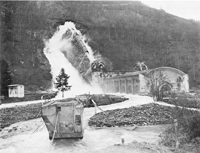
As part of Operation Blackcock , troops of the British 2nd Army had captured the so-called Rur triangle in January 1945. The northern section of the Rur Front to Roermond was then taken over by the 9th US Army under General Simpson , which had been under the 21st Army Group of British Field Marshal Bernard Montgomery since the Battle of the Bulge . Originally, Operation Grenade was supposed to begin shortly after Operation Veritable (February 8), but this became impracticable due to the opening of two dams in the Eifel ( Rur and Urft ) : On February 10, 1945, the Wehrmacht blew up the closures of the Kermeter tunnel at the power plant Heimbach , whereupon the Urfttalsperre ran empty up to the level of the Kermeter tunnel. On February 8, they also blew up the closures of the bottom drainage tunnels of the Schwammenauel dam ( Rursee ). Both together created a flood downstream that silted up the floodplain and made it difficult for the attackers to advance.
The Rur and the Erft were two natural obstacles; behind it was the Cologne Bay . At Linnich there was an egg-shaped plateau (about 130 meters above sea level). The country was dominated by agricultural areas (especially grain and beet fields).
There were also two extensive forest areas: the Hambach Forest east and south-east of Jülich and the forest between Heinsberg and Venlo , in which the Maas-Rur position was located ( Brachter Forest , Diergardtscher Forest east of Swalmen , Elmpter Forest). In addition, the planners saw some rivers - or the muddy terrain to be expected there - directly west of the Rur as an obstacle. The winter of 1944/45 was extremely cold and wet and did not end in March 1945.
When the planning of the operation began, the Rur dams were still in German hands. Usually the Rur is a calm river that is around 30 meters wide in many places. The planners assumed that the thaw and the destruction of the Rur dams would turn them into a lake up to two kilometers wide. Even after the flood had receded, the terrain would be so boggy that vehicles could not maneuver outside of fixed paths. The planners chose crossing points at the narrowest parts of the river; mostly where there were destroyed bridges.
The Erft flows diagonally through the Cologne Bay. It divides the area between the Rur and the Rhine about halfway and flows into the Rhine near Neuss, west of Düsseldorf.
Neither the Erft nor the Erft Canal - it runs parallel to the river in many places - were major military obstacles, but a green belt up to a kilometer wide helped make the two bodies of water a good natural line of defense. This was true in both directions: if you had conquered the area up to the river complex, you had flank protection if you moved downstream towards Neuss, as the 9th US Army intended.
The largest city to be crossed by grenade troops was Mönchengladbach , then a textile city . Rheydt joined directly on its southern border ; both together had 310,000 inhabitants before the war. Düren and Jülich (both on the Rur and already largely destroyed by Western Allied bombs), Elsdorf , Erkelenz , Dülken and Viersen (on this route you could bypass Mönchengladbach to the north) were significantly smaller, but of a certain importance as transport hubs. Krefeld , a town with a Rhine bridge ( Krefeld-Uerdinger Bridge ), is 20 km northeast of Viersen .
German defense
From autumn 1944 onwards, the Germans had used many forced laborers to build defenses in the area. They had created three lines: the first on the east bank of the Rur, the second six and the third eleven kilometers behind. The third was connected to the Erft. Essentially, they were trenches or walls in a zigzag pattern (this restricted the effect of shell fragments to a smaller area - they could only fly “to the next corner”) with exits at the villages and towns. There were tank obstacles as well as anti-aircraft and field guns at irregular intervals in and between the lines. Mines and barbed wire were only found in certain places on the east bank of the Rur.
The Americans thought the defense network was well planned and organized; but all signs indicated that the Wehrmacht had far too few troops to be able to man the lines. This supported the assumption that the defense would focus on focal points in cities and villages instead of being staggered permanently.
Reconnaissance officers believed that the Germans had around 30,000 men and 70 tanks in the front section between "south of Düren" and Heinsberg. They also assumed that six divisions with 23,500 soldiers and 110 tanks were in reserve near Cologne . Four mixed divisions, which had not been in contact with the enemy for some time, were trusted to be able to intervene with 17,000 soldiers and 55 tanks.
course
On February 1, General Eisenhower gave the order to conduct Operation Grenade. From this day on, the 9th US Army noticed that the forces of the Wehrmacht were decreasing. For example, General Simpson noted on February 6th that the 5th Panzer Army was still defensive in the Eifel . His hopes for a rapid overcoming of the defensive positions on the Rur grew (“We will have some tough fighting, but I think we are going right through.”).
On February 10th at the latest, the 9th US Army was to cross the Rur and join forces with the 1st Canadian Army , which started from the Nijmegen area in a south-easterly direction as part of the battle in the Reichswald that began on February 8th at 5:00 am Rheins advanced. German soldiers opened weirs upstream after the British and Canadians advanced; on February 8, 1945 they blew up the bottom drainage pipes of the Rurtalsperre . Floods and silting up of parts of the river Rurau forced the Americans to postpone their attack until the tide had receded somewhat.
During the two weeks in which the Roer led flood artificially generated, allowed Adolf Hitler Field Marshal Gerd von Rundstedt not behind the Rhine withdraw . He argued that this would only delay an inevitable fight and ordered him to fight on the spot.
The 9th Army was finally able to cross the Rur on February 23 at Linnich, Jülich and Düren. By this time British and Canadian troops had penetrated into the Goch area ; they had won the battle in the Reichswald with high losses . It was only in the last days of February that Hitler was persuaded to vacate the promontory near Roermond - the Maas-Rur position , which had been provisionally fortified since autumn 1944 - was now threatened by encirclement from both sides.
The retreating German troops only offered stronger resistance in places. Erkelenz was taken on February 26 by troops of the 102nd US Infantry Division and Mönchengladbach on March 1 by a regiment of the 29th US Infantry Division . On the same day, parts of the 2nd US Armored Division reached the outskirts of Krefeld after they had found an intact bridge over the North Canal . Attempts to take possession of the Rhine bridges at Uerdingen or Rheinhausen , however, failed. Venlo , Brüggen , Kaldenkirchen and Viersen and Anrath were also occupied on March 1st .
On March 3, American and British-Canadian troops met near Geldern . The Germans tried to hold a bridgehead over the Rhine near Wesel long enough to allow the troops of the 1st Parachute Army to retreat. This bridgehead was eliminated in heavy fighting until March 11th with the cooperation of Western Allied troops after the last German bridges had been blown up. On March 4th the city of Moers was occupied, on March 5th the towns of Homberg and Rheinhausen opposite the Duisburg bank of the Rhine. On March 4, the German troops blew up the Rhine bridges to Hochfeld , Wanheimerort , Ruhrort and Uerdingen .
The 9th Army claimed to have killed around 6,000 German soldiers and taken 30,000 prisoners in the context of Operation Grenade with their own casualties of less than 7,300 men (including 1,330 dead).
literature
- Charles B. MacDonald: The Last Offensive. United States Army in World War II, European Theater of Operations. Office of the Chief of Military History, Department of the Army, Washington DC 1973. ( Online ).
- Ludwig Hügen:
- The war is ending. Lower Rhine reports on Operation Grenade 1945. (Series of publications by the district of Kempen-Krefeld 18) . 1974. 256 pages.
- "Operation Grenade": the occupation of the cities of M.-Gladbach, Rheydt, Viersen and Krefeld-Uerdingen by American tank divisions and the tank battle in Schiefbahn on 1./2. March 1945 . Self-published by the author, 2003, 163 pages
- Hans Kaiser: Kempen under the swastika. Volume 2: A district town on the Lower Rhine during National Socialism . Series of publications by the district of Viersen, Volume 49.2, Viersen 2014, 850 pages.
- Klaus Marcus: The great war and the small town . Viersen in World War II, 777 pages
Web links
Individual evidence
- ^ Kermeter tunnel 1945. Retrieved September 29, 2012 .
- ↑ Hans-Dieter Arntz : End of the war 1944/1945 - Between the Ardennes and the Rhine . - Euskirchen. 2nd supplemented edition 1985. p. 169.
- ↑ The last fighting in the region
- ^ US Library of Congress March 1, 1945: HQ Twelfth Army Group situation map
- ↑ Michael Clodfelter (2017). Warfare and Armed Conflicts: A Statistical Encyclopedia of Casualty and Other Figures, 1492-2015 (4th ed.). ISBN 978-0786474707 .