
Urfttalsperre
| Urfttalsperre | |||||||||||||
|---|---|---|---|---|---|---|---|---|---|---|---|---|---|
 in the foreground the Obersee |
|||||||||||||
|
|||||||||||||
|
|||||||||||||
| Coordinates | 50 ° 36 '8 " N , 6 ° 25' 8" E | ||||||||||||
| Data on the structure | |||||||||||||
| Lock type: | Gravity dam | ||||||||||||
| Construction time: | 1900-1905 | ||||||||||||
| Height above valley floor: | 55 | ||||||||||||
| Height above foundation level : | 58.5 | ||||||||||||
| Height of the structure crown: | 324 m above sea level NHN | ||||||||||||
| Building volume: | 135,000 m³ | ||||||||||||
| Crown length: | 226 m | ||||||||||||
| Crown width: | 6 m | ||||||||||||
| Base width: | 50.5 m | ||||||||||||
| Radius of curvature : | 200 m | ||||||||||||
| Power plant output: | 16 MW | ||||||||||||
| Operator: | Eifel-Rur water association | ||||||||||||
| Data on the reservoir | |||||||||||||
| Altitude (at congestion destination ) | 322.5 m above sea level NHN | ||||||||||||
| Water surface | 2.16 km² | ||||||||||||
| Reservoir length | 12 km | ||||||||||||
| Storage space | 45.51 million m³ | ||||||||||||
| Total storage space : | 47.75 million m³ | ||||||||||||
| Catchment area | 373.9 km² | ||||||||||||
| Design flood : | 220 m³ / s | ||||||||||||
| Particularities: |
no shipping |
||||||||||||
| Common use is directed u. a. according to the ordinance on the Eifel National Park (NP-VO Eifel) | |||||||||||||
 on the left the Obersee of the Rursee |
|||||||||||||

The Urfttalsperre in the North Eifel is a 58.5 m high, 226 m long and from 1900 to 1905 built dam in the southwest part of the North Rhine-Westphalian district of Euskirchen , which damms the Urft to the 2.16 km² Urftstausee ( Urftsee ).
Its dam and the Urftstausee, which was then the largest European reservoir, have belonged to the Eifel-Rur Water Association since 1993 .
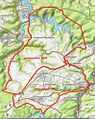
Geographical location
The Urftstausee reservoir, which consists of the Urfttalsperre and Urftstausee, is located in the Rureifel (part of the northern Eifel ) south of the Kermeter or north-northeast of the Dreiborn plateau between Simmerath - Rurberg (neighboring city region of Aachen ) in the west-north-west and Schleiden - Gemünd (district of Euskirchen) in the east-south-east. It is located directly above the Obersee (main pre- basin of the Rurstausees ), in which the water from Urft and Rur is dammed, and extends into the Eifel National Park , founded in 2004 , which is framed by the boundaries of the Hohes Venn-Eifel Nature Park . From 1946 to 2005 it was in the Vogelsang military training area.
Urft dam in the former Vogelsang military training area (1945–2005)

Urftstausee, October 2009


dam

The Urfttalsperre is 6.8 km west-north-west of the northern Schleiden district of Gemünd , 2.7 km north-west of the NS-Ordensburg Vogelsang, which belongs to Schleiden, and 3 km east-south-east of the Simmerath district of Rurberg . The dam was built from 1900 to 1905 as a weight dam curved towards the water side with a water-side fill (Intze wedge) up to about half the height of the dam.
Your general planning was developed by Otto Intze from Aachen and built according to the Intze principle ; Intze was also the site manager. The building materials were first transported to Gemünd on the Oleftalbahn and then transported to the construction site of the dam on an approximately 13 km long, narrow-gauge material train . Visitors could also drive from Gemünd on the material train to the construction site for 1 mark . Today the hiking trail to the reservoir runs along the former route. Bricked with quarry stones from locally mined greywacke and clay slate , the barrier wall is 58.5 m high above the foundation base and around 226 m long at its crown, 6 m at its crown and 50.5 m wide at its base. The dam was the highest dam in Europe until the Bober dam was built in 1912.
When it was completed, the Urft Dam served as a model for many other projects at home and abroad, after the industrialization of water management became increasingly important at the end of the 19th century . The trial damming began in November 1904 and the water management inspection took place on August 26, 1905.
Separated from the Urft Dam by the base of a narrow peninsula, north of the wall is the flood relief as an overflow weir with a maximum width of 91 m and cascades with a total of 33 steps. Inside the wall, clay pipes were installed vertically at a distance of 2.5 m to divert any water.
Several bottom outlet towers provide access to two different depths running control passages through which the state of the Urfttalsperre can be checked. The lower inspection passage runs along their foundation joint. In the years 1994 to 2000 the barrier wall was thoroughly renovated. Among other things, the problem of bed water pressure was solved. In addition, between 1994 and 1999 it was given two patrols that were driven by blasting , a total of 320 m long, an average of 3.10 m high and 2.40 m wide and also a new seal, drainage and numerous measuring devices.
The Eifel-Rur Water Association , which has existed since January 1, 1993 after an organizational transition period that began in 1990, celebrated the 100th anniversary of the Urft Dam on August 26, 2005.
Since the Paulushofdamm of the Obersee of the Rurstau system was raised by 14 meters in 1955, the Urfttalsperre is not only on the water side, but also on the air side due to the water of the Rurstaue located directly downstream below the Urfttalsperre ( normal water level in the Obersee of 279.6 m above sea level) ( Obersee ) dammed a total of twelve meters high.
Reservoir
The Urftstausee ( Urftsee ) is located south of the Kermeter ridge, west-northwest of the Schleiden district of Gemünd and a little below the district of Malsbenden . When fully dammed, it is 7.85 km long (according to the German basic map ; the straight line between the end of the reservoir and the dam is 3.9 km), 2.16 km² in size and has 47.75 million m³ of storage space .
The reservoir is traversed by the Rur tributary Urft , whose water (since the dam wall existed) is usually routed through the Kermeter tunnel running in the Kermeter and through the turbines of the Heimbach power plant with its drainage into the compensation basin of the Heimbach reservoir and thus into the Rur (see also section Use and hydropower plant ); the tunnel inlet is around 900 m (as the crow flies) northeast of the Urft dam on the north bank of the reservoir. Through this artificial tunnel runoff, the Urft estuary is shifted to the Rur 111.1 km near Heimbacher district Hasenfeld . Formerly led the river naturally above the hamlet Simmerath Rurberg about the Rur-km 123.5 in the Roer. Today the water from the upper lake of the Rurstausees there overflows the old (near the mouth) lower reaches of the Urft.
The island of Krummenauel (max. 339.6 m ) is located in the reservoir, which is surrounded by a wooded landscape and whose storage destination is 322.5 m above sea level , and into it protrude the peninsulas on the Altenberg ( Auf dem Altenberg ; max. 351.5 m ), on Neffgesberg (max. 370 m ) and on Hosterauel (max. 366.7 m ), which can also be reached on foot depending on the water level.

Urftstausee at low water with the former NS-Ordensburg Vogelsang in the background

Bottom discharge tower of the Urft dam with markings to determine the water level

Air side of the Urfttalsperre with Obersee in the foreground

Victor Neels Bridge , built in 2009, named after Victor Neels, Colonel a. D., former Belgian commandant of Camp Vogelsang (1970–1980)

Subsequent inspection of the Urft reservoir

Inspection of the Urft dam in the area of the slope


history
In the time of National Socialism , the NS Ordensburg Vogelsang was built above the Urftstausees .
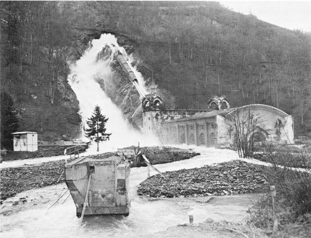
Towards the end of World War II, the area was around the Urftstausee part of the battle in Hürtgenwald whose main combat zone to km north-north-westerly in an average of 15 Hürtgenwald was. The Allies tried in vain to destroy the dam from the air. Five holes with depths of 1.50 to 3.50 m were struck in the dam wall by aerial bombs and high- explosive bombs . The parapet walls on both sides of the wall crown and the gate towers were completely destroyed.
On February 10, 1945, German troops blew up the seals in the Kermeter tunnel at the Heimbach power station , whereupon the dam drained to the level of the Kermeter tunnel. They also blew up the closures of the bottom drain tunnels of the Schwammenauel dam ( Rursee ). Both together created a flood downstream that silted up the floodplain and made it difficult for the attackers to advance. They waited until February 22nd (the Rur still had a lot of water) and then overcame the Rur and the German defensive positions in Operation Grenade .
The war damage to the dam was removed from 1945 to 1950. The area of the dam had to be demined. The use of glass mines made this particularly dangerous. The dam keeper Christian Jansen lost his life in a mine. Over 1200 bomb craters alone were counted. 2000 kg of explosive charges were removed from the inlet of the pressure tunnel. Individual bomb craters required about 6000 m³ of earth to be filled.
After the Second World War, the Urftstausee became part of the Vogelsang military training area from 1946 and was almost completely inaccessible to the public. Since the withdrawal of the Belgian military on December 31, 2005, the Urftstausee has been a core part of the Eifel National Park, which was founded in 2004 . The national park administration set up and marked new cycling and hiking routes that lead along the north bank to Gemünd and from the barrier wall south over the Dreiborn plateau and Wollseifen to Einruhr , Dreiborn and Herhahn . The Victor Neels Bridge , which was completed in autumn 2009 and serves as a bicycle and hiking path bridge over the reservoir, connects the Alte K 7 with the path to Vogelsang Internationaler Platz (in the complex of the former NS-Ordensburg Vogelsang).

Construction of the Urft Dam, 1903

Weir of the Urft Dam, 1911


Use and hydropower plant
In addition to regulating the water level in the Rur, which is dammed a little below the Urfttalsperre, the Urfttalsperre and Urftstausee are used for flood protection , low water levels and , above all, for electricity generation , the drainage of the dammed Urft via the Kermeter tunnel to the Heimbach power station in the Rur is the rule.
In a flood situation in the Urftsee or in special operational situations, there is also relief or transfer to the Obersee of the Rur. The reservoir was part of the military training area for over 50 years, and its water was correspondingly polluted by the training operations. The Obersee of the Rur is a drinking water storage room. Before water from the Urftstausee is discharged into the Obersee through the bottom outlet, outside of flood situations, a permit and a review of the water quality are required.
To generate electricity, at the same time as the dam was built, the 2.7 km long Kermeter tunnel was driven north-northeast through the Kermeter ridge and the Heimbach power plant was built. The water from the Urft emerges there on the southern mountain slopes of the Rur valley and feeds the Art Nouveau power plant, which is located on the Rur, via two downpipes. The hydropower plant with its eight Francis turbines had an output of 12 megawatts (MW) and was therefore the largest in Europe in 1905. The turbines were decommissioned in 1975 and replaced by two new, more efficient machines. Since then, the system has had an installed capacity of 16 MW, which mainly goes into operation in the mornings of the weekdays to cover the peak load. Depending on the strength of the power plant operation, a kind of ebb and flow , also known as the Urftwelle , developed in the Rur below . To prevent this, the compensation basin of the Heimbach reservoir was built.
The storage power plant is operated by RWE Innogy . Nowadays the Urft, Rur and the Oleftalsperre located a little further south are operated in a network and thus ensure the availability of around 265 million cubic meters (m³) of storage space.
Inflows and outflows
The tributaries of the Urftstausees include (with length in kilometers (km) according to the German basic map ) (sorted alphabetically):
- Arnsbach (2.1 km); Coming from the Kermeter from the north-northeast, flows into the middle section of the reservoir
- Großer Böttenbach (2.9 km); Coming from the Kermeter from the northeast, flows into the eastern part of the reservoir
- Haftenbach (0.6 km); Coming from the north from the Kermeter, flows into the western part of the reservoir
- Hohenbach (0.6 km); Coming from the Kermeter from the north-northeast, flows into the middle section of the reservoir
- Lorbach (3 km); Coming from the Kermeter from the northeast, flows into the middle section of the reservoir
- Morsbach (2.3 km); Coming from the Dreiborn plateau / from Morsbach from the south, flows into the eastern part of the reservoir
- From the Walberhof (2.4 km); Bach coming from the Dreiborn plateau / from the Walberhof from the south flows into the middle section of the reservoir
- Urft (46.3 km), flows as the main tributary from the east into the east end of the reservoir; forms the only natural drain; the Kermeter tunnel serves as an artificial drain
The drainage takes place in regular operation via the Kermeter tunnel to the Heimbach power plant located on the Rur, in the event of a backlog also into the Obersee of the Rur and in special operating situations also via the bottom drainage tunnel of the Urft dam . As a rule, the Urft and its estuary, the Rur, are flooded below the dam wall by the water from the Obersee, which extends to the air side.
Transport and tourism
West runs along the upper lake by the federal highway 266 north to Rurberg leading state road 149. From these branches as a short spur road L 166 to the east, leading to the parking lot at Paulushofdamm the upper lake. From there you can hike on the Urftseerandweg, already mentioned on the Obersee, south along the Kermeter to the Urft dam.
Kreisstraße 7 branches off near the Kermeter parking lot , which is on the Kermeter high elevations on L 15 ( Kermeterstraße ; Hasenfeld - Wolfgarten ) . The road, which is closed to public traffic, leads in numerous serpentines down to the bay at the influence of the small Haftenbach in the Urftstausee. From April to October the AVV line 231 runs to the Urfttalsperre / Haftenbach stop . From there, the Alte K 7 now only runs as a footpath and bike path along the north and north-east bank of the reservoir - past the inlet of the Kermeter tunnel - to the Gemünder district of Malsbenden , which lies above the reservoir near the Urfteinfluss. At the influence of the Haftenbach in the reservoir, the road meets the Urftseerandweg , on which the dam is reached after a short walk.
The dam of the Urftstaue can be climbed. At its northern end is the Urftseemauer excursion restaurant , the access to which is closed to motor vehicles. In front of the downstream side of the Wall is the Urft dam of the Rursee shipping company , whose electric ships “Seensucht”, “St.Nikolaus” and “Eifel” operate on the upper lake of the Rur reservoir between the Einruhr , Rurberg and Urft dam. The reservoirs and their surroundings are recreational areas used by water sports enthusiasts and those seeking relaxation. According to the National Park Ordinance, swimming in the Urft Reservoir and driving on it is not permitted.
Between May 10, 1967 and April 8, 1993, an excursion ship, the MS Deutschland , sailed between Gemünd and the dam on Sundays .
See also
literature
- Peter Franke, Wolfgang Frey: Dams in the Federal Republic of Germany. Published by the National Committee for Large Dams in the Federal Republic of Germany (DNK) and the German Association for Water Management and Culture Building e. V. (DVWK). Systemdruck-GmbH, Berlin 1987, ISBN 3-926520-00-0 .
Web links
- Task of the Urfttalsperre. Eifel-Rur water association , accessed on December 19, 2014 .
- Urfttalsperre basin level. Eifel-Rur water association , accessed on December 19, 2014 .
- Dams directory North Rhine-Westphalia. (PDF; 115 KB) State Office for Nature, Environment and Consumer Protection North Rhine-Westphalia , October 1, 2005, accessed on December 19, 2014 .
- History of the Urft Reservoir. Bernd Hilger, accessed December 19, 2014 .
- Georg May: Urft Dam overflow on February 26, 2002. Accessed December 19, 2014 .
- 100 years of the Urftstausee. (PDF; 2.86 MB) (No longer available online.) In: lernort-vogelsang.de. August 7, 2005, archived from the original on September 29, 2007 ; Retrieved December 19, 2014 .
- Bird watching station at Urftsee. In: Eifel National Park . Eifel National Park Administration, accessed on December 19, 2014 .
- With a remote-controlled view: A dam wall is measured ( Aachener Zeitung ), from September 5, 2016, on aachener-zeitung.de
- [1] History of the Urft reservoir in old pictures, FAHeinen, Geschichtsforum Schleiden eV
References and comments
- ↑ a b c d e f g h i j k l m n o p q r s t u data sheet of the Urfttalsperre. (PDF; 152 KB) Eifel-Rur water association , accessed on December 19, 2014 .
- ↑ a b c d e f g h i j k Unknown / not researched source
- ↑ Ordinance on the Eifel National Park ( Memento of the original dated April 2, 2015 in the Internet Archive ) Info: The archive link was inserted automatically and has not yet been checked. Please check the original and archive link according to the instructions and then remove this notice. (NP-VO Eifel), dated December 17, 2003, accessed on March 1, 2014, at nationalpark-eifel.de (PDF; 65.5 KB)
- ↑ a b c d e Topographical Information Management, Cologne District Government, Department GEObasis NRW ( information )
- ↑ on the reservoir discharge see also: Matthias Kufeld, Joachim Lange, Bernd Hausmann: The catchment area of the Rur. (PDF; 10.54 MB) Report on the results of the literature research carried out as part of the AMICE project . June 28, 2010, p. 57 below (from "The water from the Urfttalsperre ..." ) , accessed on February 15, 2014 .
- ^ Kermeter tunnel 1945. Retrieved September 29, 2012 .
- ↑ Josef Lorbach: The construction of the Urfttalsperre. Georg May, accessed December 19, 2014 .
- ↑ on the reservoir discharge see also: Matthias Kufeld, Joachim Lange, Bernd Hausmann: The catchment area of the Rur. (PDF; 10.54 MB) Report on the results of the literature research carried out as part of the AMICE project . June 28, 2010, p. 107 in the middle (from "Levies of the Urfttalsperre ..." ) , accessed on February 15, 2014 .
- ↑ Heimbach power station. In: baukunst-NRW. Chamber of Architects of North Rhine-Westphalia, accessed on December 19, 2014 .
- ↑ Our hydropower plants in the Eifel - data and facts; RWE Innogy GmbH ( Memento from August 6, 2016 in the Internet Archive )
- ↑ Water information. In: National Park Eifel. Retrieved September 29, 2012 .
- ↑ Timetable line 231: Düren - Stockheim - Heimbach - Gemünd - Schleiden. Aachen Transport Association , accessed on December 19, 2014 .
- ↑ Urftsee Wall - excursion restaurant. Bernd Hilger, accessed December 19, 2014 .
- ↑ Rursee Schifffahrt - Timetable 2015. Rursee Schifffahrt KG, November 9, 2014, accessed on December 19, 2014 .
- ↑ http://db.gf-sle.de/1098-GeschichteUrftsee.pdf page 20