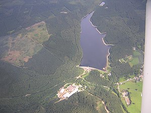
Dreilägerbachtalsperre
| Dreilägerbachtalsperre | |||||||||
|---|---|---|---|---|---|---|---|---|---|
| Aerial view of the Dreilägerbachtalsperre | |||||||||
|
|||||||||
|
|
|||||||||
| Coordinates | 50 ° 39 '38 " N , 6 ° 12' 56" E | ||||||||
| Data on the structure | |||||||||
| Construction time: | 1909-1911 | ||||||||
| Height above valley floor: | 33 m | ||||||||
| Height above foundation level : | 38 m | ||||||||
| Height of the structure crown: | 393 m | ||||||||
| Building volume: | 85 000 m³ | ||||||||
| Crown length: | 240 m | ||||||||
| Crown width: | 3 m | ||||||||
| Base width: | 25 m | ||||||||
| Radius of curvature : | 350 m | ||||||||
| Operator: | Water extraction and treatment company Nordeifel | ||||||||
| Data on the reservoir | |||||||||
| Altitude (at congestion destination ) | 391.5 m | ||||||||
| Water surface | 40 ha | ||||||||
| Storage space | 3.67 million m³ | ||||||||
| Total storage space : | 4.28 million m³ | ||||||||
| Catchment area | 22.9 km² | ||||||||
| Design flood : | 19 m³ / s | ||||||||
The Dreilägerbachtalsperre is located in Roetgen in the Aachen city region in the northern Eifel . It was built for the purpose of supplying drinking water and is operated by the water production and treatment company Nordeifel , a 50 percent subsidiary of enwor-energie & wasser vor ort GmbH and a 50 percent subsidiary of Stadtwerke Aachen .
Dam wall
The dam wall of the dam was built from 1909 to 1911 (or 1912 ) according to the Intze principle . The gravity dam consists mainly of stamped concrete; the upper area (approx. 6 m) was built from quartzite rubble stones. There are no vertical joints in the wall. On the water side there was originally a wedge-shaped earth fill (Intze wedge). The upper half of the wall was provided with a seal, which was protected with a facing. (This and the information in the table still partly relate to the old wall before the renovation.) A wing dam is arranged on the side.
The wall was renovated between 1990 and 1993. She got an inspection passage on the water side and a facing. The wall was also widened and the volume of the wall increased.
Flood relief
The flood relief is located on the left side of the slope and, before the renovation, consisted of five jacks with openings offset in their height and a weir flap . Today there is a new flood relief with a round overflow funnel in the storage space with a connected chute.
Storage space
The storage space is stated differently in different sources. The specified pool volume of 4.28 million m³ is probably the total storage space, while 3.67 million m³ is likely to be the storage volume in the case of the lower operational stowage.
Drinking water treatment
At the foot of the dam, the water extraction and processing company Nordeifel mbH (WAG) operates a treatment plant that treats the water from the dam system in the northern Eifel. For this purpose, the removed water is ultrafiltered using membrane filtration technology. Particles and microorganisms (bacteria) are removed. This is followed by hardening, residual deacidification and a slight chlorination of drinking water. The drinking water obtained is fed into the pipeline network of STAWAG (city of Aachen) and enwor (district of Aachen and district of Heinsberg). In addition to a large part of the city of Aachen and the city region of Aachen ( Alsdorf , Baesweiler , Eschweiler , Herzogenrath , Stolberg , Würselen ), part of the Heinsberg district ( Übach-Palenberg ) and the Dutch cities of Vaals and Kerkrade are supplied with drinking water from here.
In order to secure the water supply, the Dreilägerbachtalsperre is connected to the Kalltalsperre via the Kallstollen and further to the Obersee of the Rurtalsperre via the Heinrich-Geis- Tunnel and a pumping station . Another water treatment plant for the same supply area is located at the Wehebachtalsperre .
The southern part of the Aachen city region , i.e. the municipalities of Monschau , Simmerath and parts of Roetgen, are supplied with water from the Perlenbachtalsperre , as is the city of Heimbach in the Düren district .
Others
The dammed body of water is the Dreilägerbach. Furthermore, the dam receives inflow from the artificial ditches Schleebachgraben and Hasselbachgraben and via a connecting tunnel from the Kalltalsperre 6 km away . The flood relief flows into the Schleebach, a tributary of the Vicht .
The Dreilägerbachtalsperre has a pre-basin with a volume of around 50,000 m³.
See also
Individual evidence
Web links
- Dams directory NRW (PDF; 124 kB)


