
Roetgen
| coat of arms | Germany map | |
|---|---|---|

|
Coordinates: 50 ° 39 ′ N , 6 ° 12 ′ E |
|
| Basic data | ||
| State : | North Rhine-Westphalia | |
| Administrative region : | Cologne | |
| Circle : | City region Aachen | |
| Height : | 410 m above sea level NHN | |
| Area : | 39.03 km 2 | |
| Residents: | 8648 (Dec. 31, 2019) | |
| Population density : | 222 inhabitants per km 2 | |
| Postal code : | 52159 | |
| Area code : | 02471 | |
| License plate : | AC, MON | |
| Community key : | 05 3 34 024 | |
| LOCODE : | DE OET | |
| Community structure: | 3 districts | |
| Address of the municipal administration: |
Hauptstrasse 55 52159 Roetgen |
|
| Website : | ||
| Mayor : | Jorma Klauss ( SPD ) | |
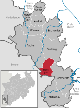
| Location of the municipality of Roetgen in the Aachen city region | ||
 .svg) |
||

Roetgen [ ˈʁøːtçən ] is a municipality in North Rhine-Westphalia on the border with Belgium. It belongs to the Aachen city region . Due to the proximity to Aachen , the community became particularly interesting for commuters , so there are various new development areas from the 1970s, 1980s and 1990s as well as an industrial area from the 1990s. Since November 27, 2012, the municipality officially bears the title Gate to the Eifel .
geography
Roetgen is located in the north of the Hohes Venn-Eifel nature park on the little river Weser , which rises a few kilometers south. The Dreilägerbachtalsperre lies between Roetgen and Rott and is fed by the Dreilägerbach and the artificially created Schleebachgraben and Hasselbachgraben. The connected waterworks of WAG Nordeifel supplies large parts of Aachen and Kerkrade in the Netherlands with drinking water .
The districts of Roetgen, Rott and Mulartshütte , which is the oldest district of Roetgen, belong to the municipality of Roetgen .
In the northwest the city of Aachen borders with the districts Kornelimünster and Walheim , in the northeast Stolberg with the districts Venwegen and Zweifall , in the southeast Simmerath with the district Lammersdorf on Roetgen. To the west, across the German-Belgian border , are the town of Eupen and the municipality of Raeren , whose district of Petergensfeld, north of the Charliersmühle, is directly adjacent to Roetgen.
history
The area around Roetgen was at the intersection of important Roman roads between Colonia Ulpia Traiana and Augusta Treverorum and from Marcodurum over the Eifel to Leodicum . Iron smelting is already documented in antiquity, but settlement is not.
A document from 1430, which describes the right of inheritance at the Vichtbach , shows the historical origins of medieval iron smelting in the Mulartshütte riding school near Mulartshütte. The tax collection lists of the Monschauer Land from 1551 show the name of the first settlers of Roetgen who had to clear forest and heathland; however, an initial settlement can be assumed as early as the 15th century. In 1555, what was then the hamlet of Petergensfeld , part of the Duchy of Limburg, was ceded to Spain. See Spanish Netherlands .
The first church was built between 1636 and 1660, of which only a part - today's Marienkapelle - has been preserved. Reformed people also came to Roetgen in the 18th century, and the place received a Protestant church .
Cloth making and weaving were the economic basis of Roetgen in the 18th century. A characteristic architectural example of this period is the old hunter's house in Mulartshütte.
Territorial belonged Roetgen to the French Revolution to the Duchy of Jülich . During the reorganization in the Congress of Vienna in 1815, it was added to Prussia .
In 1885 Roetgen was connected to the Aachen - St. Vith railway line , which was still German at the time. When, after the First World War the region Eupen-Malmedy fell to Belgium, Roetgen was border village. The Vennbahn became Belgian national territory and Roetgen station became a Belgian exclave . The logistics and economic supply of the area was endangered.
The German-Belgian border treaty of 1956 regulated, among other things, the return of certain areas to Germany. This took place on August 28, 1958 ( Federal Law Gazette II p. 262 ).
1909 Dreilaegerbach dam had been begun construction, the 1926 through a tunnel with the Kalltal and later on in the meantime built Kalltalsperre and Rurtalsperre with Rurtalsperre was connected.
The Second World War represented a further serious break in the economic history of the region. On September 12, 1944 at 2:30 pm, the Americans marched into the hamlet of Schwerzfeld in Roetgen via Raeren- Petergensfeld . It was the first place in Germany to be conquered by the Americans - the New York Times reported on September 14, 1944. After the end of the war, Belgium initially planned to annex the exclave created by the Vennbahn, but abandoned these plans in April 1949 fall.
From 1815 to 1971 Roetgen belonged to the Monschau district, which was dissolved by the Aachen law . The then still independent towns of Roetgen, Rott and Zweifall, to which Mulartshütte belonged, formed the Roetgen office since 1934 . On July 1, 1969, they merged to form the new municipality of Roetgen. On January 1, 1972, the district of Zweifall (with the exception of Mulartshütte) was separated by the Aachen law, and the new municipality of Roetgen was assigned to the district of Aachen and the district court of Monschau.
Roetgen now relies on tourism as a gateway to both the Eifel and the High Fens . The location close to the border, an economic disadvantage in the post-war period, is now an advantage for the community.
politics
Municipal council


Since the 2014 local elections, the Roetgens local council has consisted of 30 council members. In the past local elections, the following allocation of seats in the municipal council resulted:
| SPD | CDU | UWG | GREEN | FDP | total | |
| 2014 | 8th | 9 | 6th | 5 | 2 | 30 seats |
| 2009 | 8th | 7th | 5 | 4th | 2 | 26 seats |
| 2004 | 8th | 11 | - | 5 | 2 | 26 seats |
The mayor is an additional member of the council.
mayor
Jorma Klauss was elected as the new mayor in a runoff election in September 2015 with 56.79% of the vote. Predecessor Manfred Eis (SPD) was no longer running.
Community partnerships
The municipality of Roetgen maintains partnerships with the French Wervicq-Sud (since 1967) and with the Saxon Neumark (since 1990).
traffic

Until the closure of the Vennbahn, which was used as a museum railway until 2001 (Belgian territory), there was a train station in Roetgen, which is located in the municipality of Raeren. After the route was dismantled in 2010, the Vennbahn cycle path was created on the route . The place can be reached via the federal road 258 - also known as the Himmelsleiter near Roetgen because of the straight, steep inclines . Aachen is about 17 km away, Monschau 15 km and Simmerath 10 km. The municipality of Roetgen is part of the Aachen Transport Association (AVV), there is a good bus connection in local public transport . a. to Aachen. The next major train station is Aachen Hbf with connections to Brussels , Düsseldorf , Cologne and Paris as well as to regional destinations in the Euregio Maas-Rhein , which can be reached with the Euregiobahn .
The nearest airports are in Liège (around 60 km), Maastricht (around 60 km), Cologne / Bonn (around 90 km) and Düsseldorf (around 100 km).
Eifelsteig
The 313 km long Eifelsteig hiking trail that starts in Kornelimünster leads through Roetgen. The hiking route leads through the Eifel and ends in the Roman imperial city of Trier.
Attractions
- The Marienkapelle is the remaining part of the first Catholic parish church in Roetgens, which was partially demolished after the neo-Gothic building of the Hubertuskirche (1854-1856). It was consecrated to Saint Hubertus of Liège , the Virgin Mary and John the Baptist.
- The sculpture of a weaver by Hermann Pier (1925–1985) is in Roetgen Town Hall ; there is a copy outside in the forecourt. In addition to its artistic value, its documentary value is important, which identifies this profession as defining Roetgen's economic history.
- The Charliers mill (substructure in quarry stone, 1768) is a former water mill (now a residential building) on the Weser . Stage 1 of the Eifelsteig also runs in the landscape with pastures, rows of beeches and ponds that extends behind the mill .

Roetgen, Catholic Church of St. Hubertus

Marienkapelle Roetgen

.JPG)

Sons and daughters of the church
- Edgar Brunner (* 1943), statistician and university professor
- Albert Charlier (1814–1894), industrialist, wagon manufacturer
- Alois Gerards (1888–1971), District Administrator in Monschau
- Pit Gottschalk , journalist and media manager, u. a. Editor-in-chief Sport Bild
- Lotti Krekel (* 1941), actress and singer
- Albert Lauscher (1872–1944), Catholic priest, high school teacher, professor of theology and center party politician
- Wilhelm Rombach (1884–1973), District Administrator in Düren (1920–1923), District President (1923–1928) and Lord Mayor of Aachen (1928–1933), after the murder of Franz Oppenhoff , once again briefly Lord Mayor of Aachen in 1945. Excellent with the Great Cross of Merit of the Federal Republic of Germany (1952).
- Hubert vom Venn (* 1953), cabaret artist and writer
- Marga Wilden-Hüsgen (* 1942), mandolinist and music researcher
- Mathias Wilms (1893–1978), founder of the first free trade union in Germany after the Second World War
Web links
- Website of the municipality of Roetgen
- Heimat- und Geschichtsverein Roetgen eV Dieter Fischer, Rolf Wilden, accessed on May 7, 2015 .
- "It is lucky that nobody is dead". Tornado drilled bricks like knives into house facades on March 14, 2019 on t-online.de, accessed on March 16, 2019
Individual evidence
- ↑ Population of the municipalities of North Rhine-Westphalia on December 31, 2019 - update of the population based on the census of May 9, 2011. State Office for Information and Technology North Rhine-Westphalia (IT.NRW), accessed on June 17, 2020 . ( Help on this )
- ↑ Federal Statistical Office - area changes from 01.01. until March 31, 2013
- ↑ https://www.youtube.com/watch?v=nj9WGn0RvTI Second World War - End of the war in NRW 1945. Film on youtube
- ↑ Bettina Blank : The West German States and the Emergence of the Federal Republic , Munich 1995, p. 220 [1]
- ↑ Martin Bünermann: The communities of the first reorganization program in North Rhine-Westphalia . Deutscher Gemeindeverlag, Cologne 1970, p. 78 .
- ↑ Martin Bünermann, Heinz Köstering: The communities and districts after the municipal territorial reform in North Rhine-Westphalia . Deutscher Gemeindeverlag, Cologne 1975, ISBN 3-555-30092-X .
- ↑ State Returning Officer NRW: Municipal elections 2014 - final result for Roetgen. Retrieved November 28, 2015 .
- ↑ Andreas Gabbert, Heiner Schepp: Jorma Klauss inherits Manfred Eis. Aachener Zeitung, September 27, 2015, accessed on August 30, 2019 .
- ↑ Bike tour on the Vennbahn route: three days, three countries . In: Spiegel Online . June 19, 2015 ( spiegel.de [accessed March 14, 2018]).

Aachen | Alsdorf | Baesweiler | Eschweiler | Herzogenrath | Monschau | Roetgen | Simmerath | Stolberg (Rhineland) | Würselen