
Aachen district
| coat of arms | Germany map |
|---|---|

|
_in_Germany.svg)
Coordinates: 50 ° 45 ' N , 6 ° 15' E |
| Basic data (as of 2009) | |
| Existing period: | 1972-2009 |
| State : | North Rhine-Westphalia |
| Administrative region : | Cologne |
| Regional association : | Rhineland |
| Administrative headquarters : | Aachen |
| Area : | 546.33 km 2 |
| Residents: | 308,273 (Sep. 30, 2009) |
| Population density : | 564 inhabitants per km 2 |
| License plate : | AC |
| Circle key : | 05 3 54 |
| NUTS : | DEA25 |
| Circle structure: | 9 municipalities |
| Address of the district administration: |
Zollernstrasse 10 52070 Aachen |
| Website : | |
| District Administrator : | Carl Meulenbergh ( CDU ) |
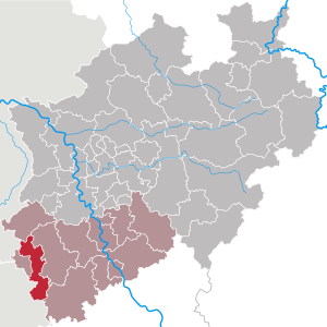
| Location of the Aachen district in North Rhine-Westphalia | |
  |
|

The Aachen district was a district in the far west of North Rhine-Westphalia . It was part of the Aachen region , thus the Euregio Meuse-Rhine, and belonged to the Cologne region . It went back to the district of Aachen , the district of Monschau and parts of the districts of Düren , Geilenkirchen-Heinsberg and Jülich .
The District of Aachen was under Aachen Act disbanded at the end of October 20th 2009, and from the nine municipalities of the district Aachen and the city of Aachen with effect of 21 October 2009 as a new community association the authority Aachen region formed.
For geography, castles, museums, economy and transport see the Aachen city region . For the coat of arms see here .
Circle structure

The Aachen district stretched from the city of Baesweiler in the north for about 50 kilometers to the city of Monschau in the south. At its narrowest point, it was only 6 kilometers wide.
In the Aachen district there were recently nine municipalities belonging to the district , seven of which had the title " city ". Six of them were middle district cities with 25,000 to 60,000 inhabitants.
| local community | Community type | Area km² (as of June 30, 2007) |
Total population (as of December 31, 2008) |
Inhabitants per km² |
|---|---|---|---|---|
| Alsdorf | middle district city | 31.67 | 45,953 | 1,451 |
| Baesweiler | middle district city | 27.77 | 28,169 | 1.014 |
| Eschweiler | middle district city | 75.93 | 55,533 | 731 |
| Herzogenrath | middle district city | 33.40 | 47,187 | 1,413 |
| Monschau | district city | 94.62 | 12,652 | 134 |
| Roetgen | district municipality | 39.03 | 8,251 | 211 |
| Simmerath | district municipality | 111.01 | 15,610 | 141 |
| Stolberg | middle district city | 98.51 | 58,057 | 589 |
| Würselen | middle district city | 34.39 | 37,839 | 1,100 |
Although the independent city of Aachen itself did not belong to the circle Aachen, was there still the county seat . The reason for this was the fact that the district building or district office was formerly in Burtscheid . Before the merger with the city of Aachen, Burtscheid was still part of the Aachen district.
Neighboring districts and provinces
The Aachen district bordered the Heinsberg district in the north, the Düren and Euskirchen districts in the east , the Belgian province of Liège in the south and west and the Dutch province of Limburg in the west .
| Urban region border | |
|---|---|
| Total limit: | 224 km |
| To Belgium : | 43.9 km |
| To the Netherlands : | 9.7 km |
| To the district of Heinsberg : | 14.6 km |
| To the Düren district : | 95.4 km |
| To the Euskirchen district : | 19.3 km |
| To the city of Aachen : | 41.1 km |
history
Local reorganization as of January 1, 1972
A historic event in the history of the two circles is still relatively "young". On January 1, 1972, the Aachen and Monschau districts were merged into a new Aachen district due to the Aachen Act . In addition, there was the municipality of Baesweiler (today the city of Baesweiler ) from the dissolved Selfkantkreis Geilenkirchen-Heinsberg . Eschweiler - and thus the Aachen district - received areas from the Düren and Jülich districts. The administrative seat remained the independent city of Aachen .
The result of this regional reform program was the growth of the Aachen district to an area of 550.64 square kilometers with 285,954 inhabitants. A total of 36 towns and municipalities, offices and municipalities belonging to the district, the structure of which mostly went back to the Mairie constitution at the time of Napoleon , were dissolved and merged into seven towns and two municipalities. The formation of this area around Aachen was based on state structural and state development policy considerations. One goal of this re-planning was the connection of financially weak areas to financially strong neighbors.
The nine municipalities from 1972
Cities
Other communities
Part of the Aachen city region from October 21, 2009
The Aachen district was incorporated into the Aachen city region, which was founded in 2004, on October 21, 2009 .
Population development
| year | Residents |
|---|---|
| 1975 | 287,619 |
| 1980 | 288,683 |
| 1985 | 287,332 |
| 1990 | 294.090 |
| 1995 | 302.430 |
| 2000 | 306,580 |
| 2005 | 310.267 |
| 2009 | 308.273 |
politics
District administration

The last district administrator in the Aachen district was Carl Meulenbergh, re-elected with 50.2% on September 26, 2004 ( CDU ). The last first deputy district administrator was Hans Körfer (CDU). The last second deputy district administrator was Erwin Künkeler ( SPD ). The last third deputy district administrator was Aggi Majewski ( Bündnis 90 / Die Grünen ). The district director was Helmut Etschenberg (CDU), who became the first municipal council of the Aachen urban region after the district was dissolved.
The road traffic office for the district and city of Aachen was in Würselen .
District administrators from 1972 to 2009
- 1969–1975: Edmund Tersluisen , CDU
- 1975–1984: Helmut Schwartz , CDU
- 1984–1989: Hans Günter Bömeke , SPD
- 1989–1994: Walter Josef Meyer , SPD
- 1994–2009: Carl Meulenbergh , CDU
Senior district directors from 1972 to 1997
- 1972–1991: Friedrich Wilhelm Janssen
- 1991–1997: Walter Fricke, SPD
Results of the district elections from 1972 to 2004
The list only includes parties and voter communities that received at least 1.95 percent of the votes in the respective election:
| year | CDU | SPD | FDP | Green 1 | REP |
|---|---|---|---|---|---|
| 1972 | 48.7 | 45.7 | 4.5 | ||
| 1975 | 48.4 | 46.4 | 5.3 | ||
| 1979 | 47.4 | 47.3 | 4.7 | ||
| 1984 | 44.6 | 45.0 | 3.3 | 7.2 | |
| 1989 | 38.7 | 46.0 | 4.4 | 6.6 | 4.3 |
| 1994 | 44.2 | 43.9 | 2.8 | 8.0 | 1.1 |
| 1999 | 52.5 | 36.8 | 3.0 | 5.3 | |
| 2004 2nd | 43.9 | 32.5 | 6.3 | 8.2 | 3.3 |
1 Greens: 1984 and 1989: Greens, from 1994: B'90 / Greens
2 2004: additionally: UWG: 5.7%
Source: relevant issue of the State Statistical Office (LDS NRW), Mauerstr. 51, Düsseldorf, with the election results at the district level.
License Plate
On July 1, 1956, the district and the independent city of Aachen were assigned the distinctive sign AC when the license plates that are still valid today were introduced . It was in effect until the district was dissolved and is now used by the urban region.
See also
literature
- Ulrich Coenen: Architectural treasures in the Aachen district . Aachen 1987.
- Günter Marenberg: Natural monuments in the Aachen district . Aachen 1998.
- Thomas Müller: Forced labor in the Aachen district . Aachen 2002.
- District of Aachen - The District Administrator (Hrsg.): Statistical yearbook of the district of Aachen 2008 (= Statistical yearbook . 45th edition). Aachen 2008 ( ulb.uni-bonn.de [PDF; 3.0 MB ; accessed on January 18, 2015]).
- District of Aachen - The District Administrator (Hrsg.): Statistical yearbook of the district of Aachen 2009 (= Statistical yearbook . 46th edition). Aachen 2009 ( ulb.uni-bonn.de [PDF; 2.2 MB ; accessed on January 18, 2015]).
swell
- Statistical yearbook of the Aachen district 2006 (43rd edition)
- State Office for Data Processing and Statistics North Rhine-Westphalia (official population figures)
- Individual evidence
- ^ Federal Statistical Office (ed.): Historical municipality directory for the Federal Republic of Germany. Name, border and key number changes in municipalities, counties and administrative districts from May 27, 1970 to December 31, 1982 . W. Kohlhammer, Stuttgart / Mainz 1983, ISBN 3-17-003263-1 , p. 305 .
- ^ State database North Rhine-Westphalia

Before the founding of North Rhine-Westphalia in what is now North Rhine-Westphalia, the (rural) districts: Bilstein | Blankenheim | Bochum | Brakel | Frets | Dortmund | Duisburg | Düsseldorf | Elberfeld | Eslohe | Food | Geilenkirchen | Gelsenkirchen | Gemünd | Gimborn | Gladbach | Grevenbroich-Neuss | Gummersbach | Hagen | Hamm | Hattingen | Heinsberg (1816-1932) | Homburg | Hörde | Kempen | Krefeld | Lechenich | Lennep | Medebach | Mettmann | Mülheim am Rhein | Mülheim an der Ruhr | Neuss | Opladen | Rahden | Rheinbach | Rheinberg | Ruhrort | Schwelm | Solingen | Solingen-Lennep | Uckerath | Waldbröl | Wipperfürth
Former North Rhine-Westphalian (rural) districts: Aachen (1816–1971) | Aachen (1972–2009) | Ahaus | Altena | Arnsberg | Beckum | Bergheim (Erft) | Bielefeld | Bonn | Borken (1816–1974) | Brilon | Büren | Coesfeld (1816–1974) | Detmold | Dinslaken | Düren (1816–1971) | Düsseldorf-Mettmann | Erkelenz | Geilenkirchen-Heinsberg | Geldern | Grevenbroich | Halle (Westphalia) | Höxter (1816–1974) | Iserlohn | Jülich | Kempen-Krefeld | Cologne | Lemgo | Lippstadt | Lübbecke | Lüdenscheid | Lüdinghausen | Meschede | Minden | Moers | Monschau | Munster | Paderborn (1816–1974) | Rees | Rhein-Wupper-Kreis | Schleiden | Selfkantkreis Geilenkirchen-Heinsberg | Victories | Siegkreis | Soest (1817–1974) | Steinfurt (1816–1974) | Tecklenburg | Unna (1930–1974) | Warburg | Warendorf (1816–1974) | Wiedenbrück | Wittgenstein