
Lemgo district
| coat of arms | Germany map |
|---|---|

|

Coordinates: 52 ° 2 ′ N , 8 ° 55 ′ E |
| Basic data (as of 1972) | |
| Existing period: | 1932-1972 |
| State : | North Rhine-Westphalia |
| Administrative region : | Detmold |
| Regional association : | Westphalia-Lippe |
| Administrative headquarters : | Lemgo |
| Area : | 584.6 km 2 |
| Residents: | 158,900 (Dec. 31, 1971) |
| Population density : | 272 inhabitants per km 2 |
| License plate : | LE |
| Circle key : | 05 7 37 |
| Circle structure: | 8 municipalities |
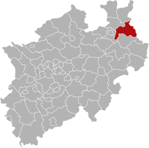
| Location of the Lemgo district in North Rhine-Westphalia | |
  |
|
The county Lemgo (1939-1969: County Lemgo ) was from 1932 to 1972 existing county and as such first part of the Free State of Lippe and in 1947 part of the North Rhine-Westphalian administrative district of Detmold . The district town was Lemgo , which was initially independent and was affiliated to the district in 1934 .
Before the municipality reform, the district was divided into 75 municipalities, five of which had city rights. Until 1967 there were also four uninhabited forest districts. Due to the "Law to reorganize the district of Lemgo" of November 5, 1968, the communities were merged on January 1, 1969 to form the eight new cities and communities Bad Salzuflen , Barntrup , Dörentrup , Extertal , Kalletal , Lemgo, Leopoldshöhe and Oerlinghausen .
geography
Neighboring areas
In 1969, the Lemgo district bordered clockwise in the north, beginning with the Minden district (in North Rhine-Westphalia), the Grafschaft Schaumburg and Hameln-Pyrmont districts (both in Lower Saxony ) and the Detmold , Paderborn , Bielefeld and Herford districts (all in turn in North Rhine-Westphalia).
history
The Lemgo district was created in the Free State of Lippe in 1932 due to the municipal reform. It was formed from the union of the District Offices Brake and Schötmar with the unofficial cities of Barntrup , Oerlinghausen and Schötmar . In 1934, the cities of Lemgo and Bad Salzuflen were also incorporated into the new district, whose district administration was located in Brake Castle . Since then 77 towns and communities have belonged to the Lemgo district.
On April 1, 1939, the two communities Oberwüsten and Unterwüsten were merged to form the municipality of Wüsten . The communities of Währentrup and Mackenbruch were merged on April 1, 1957 with parts of the former community of Wellentrup (renamed Kachtenhausen on December 11, 1963) to form the new Helpup community.
Before the municipality reform, the district was divided into 75 municipalities, of which Bad Salzuflen, Barntrup, Lemgo, Oerlinghausen and Schötmar had town charter. Until 1976 there were also four uninhabited forest districts. Due to the "Law to reorganize the Lemgo district" of November 5, 1968, the communities were merged on January 1, 1969 to form the eight new cities and communities of Bad Salzuflen, Barntrup, Dörentrup , Extertal , Kalletal , Lemgo, Leopoldshöhe and Oerlinghausen. The communities Hörstmar and Trophagen from the Detmold district were also incorporated into the city of Lemgo. Kachtenhausen and Loßbruch moved to the Detmold district and were incorporated into Lage and Detmold . On October 1, 1969, the district became the district of Lemgo.
The Lemgo district was merged with the Detmold district in what is now the Lippe district on January 1, 1973 under the Bielefeld Act . Detmold became the seat of the district administration .

Location of the district in the administrative district of Detmold (1949–1968)
Old circle sign, today's location: Vlotho


Population development
| year | Residents | source |
|---|---|---|
| 1933 | 87,865 | |
| 1939 | 90,664 | |
| 1946 | 123.396 | |
| 1950 | 131,609 | |
| 1960 | 133,600 | |
| 1968 | 151,300 | |
| 1970 | 155,300 | |
| 1971 | 158,900 |
politics
Results of the district elections from 1946
The list only shows parties and constituencies that received at least two percent of the votes in the respective election.
Share of votes of the parties in percent
| year | SPD | CDU | FDP | BHE | KPD |
|---|---|---|---|---|---|
| 1946 | 48.6 | 40.7 | 4.9 | 5.8 | |
| 1948 | 45.9 | 34.8 | 15.1 | 5.1 | |
| 1952 | 46.9 | 18.6 | 21.4 | 10.5 | |
| 1956 | 55.3 | 19.0 | 18.4 | 6.2 | |
| 1961 | 53.3 | 26.3 | 17.1 | 3.3 | |
| 1964 | 56.3 | 27.7 | 16.0 | ||
| 1969 1 | 50.9 | 35.9 | 8.7 |
footnote
1 1969: additionally: NPD: 4.2%
Parishes 1969
The following table lists all 75 municipalities in the Lemgo district as of December 31, 1969, as well as their current affiliation.
License Plate
On July 1, 1956, the district was assigned the distinguishing sign LE when the vehicle registration number was introduced. It was issued until December 31, 1972.
Individual evidence
- ↑ Stephanie Reekers: The regional development of the districts and communities of Westphalia 1817-1967 . Aschendorff, Münster Westfalen 1977, ISBN 3-402-05875-8 , p. 297 .
- ↑ Stephanie Reekers: The regional development of the districts and communities of Westphalia 1817-1967 . Aschendorff, Münster Westfalen 1977, ISBN 3-402-05875-8 , p. 243 .
- ↑ Announcement of the new version of the district regulations for the state of North Rhine-Westphalia from August 11, 1969 in the Law and Ordinance Gazette for the state of North Rhine-Westphalia, year 1969, No. 2021, p. 670 ff.
- ^ Federal Statistical Office (ed.): Historical municipality directory for the Federal Republic of Germany. Name, border and key number changes in municipalities, counties and administrative districts from May 27, 1970 to December 31, 1982 . W. Kohlhammer, Stuttgart / Mainz 1983, ISBN 3-17-003263-1 , p. 324 .
- ^ A b c d Michael Rademacher: German administrative history from the unification of the empire in 1871 to the reunification in 1990. lemgo.html. (Online material for the dissertation, Osnabrück 2006).
- ↑ 1946 census
- ↑ Statistical Yearbook for the Federal Republic of Germany 1969
- ↑ Statistical Yearbook for the Federal Republic of Germany 1972
- ↑ Statistical Yearbook for the Federal Republic of Germany 1973
- ↑ Source: respective issue of the State Statistical Office (LDS NRW), Mauerstr. 51, Düsseldorf, with the election results at the district level.

Before the founding of North Rhine-Westphalia in what is now North Rhine-Westphalia, the (rural) districts: Bilstein | Blankenheim | Bochum | Brakel | Frets | Dortmund | Duisburg | Düsseldorf | Elberfeld | Eslohe | Food | Geilenkirchen | Gelsenkirchen | Gemünd | Gimborn | Gladbach | Grevenbroich-Neuss | Gummersbach | Hagen | Hamm | Hattingen | Heinsberg (1816-1932) | Homburg | Hörde | Kempen | Krefeld | Lechenich | Lennep | Medebach | Mettmann | Mülheim am Rhein | Mülheim an der Ruhr | Neuss | Opladen | Rahden | Rheinbach | Rheinberg | Ruhrort | Schwelm | Solingen | Solingen-Lennep | Uckerath | Waldbröl | Wipperfürth
Former North Rhine-Westphalian (rural) districts: Aachen (1816–1971) | Aachen (1972–2009) | Ahaus | Altena | Arnsberg | Beckum | Bergheim (Erft) | Bielefeld | Bonn | Borken (1816–1974) | Brilon | Büren | Coesfeld (1816–1974) | Detmold | Dinslaken | Düren (1816–1971) | Düsseldorf-Mettmann | Erkelenz | Geilenkirchen-Heinsberg | Geldern | Grevenbroich | Halle (Westphalia) | Höxter (1816–1974) | Iserlohn | Jülich | Kempen-Krefeld | Cologne | Lemgo | Lippstadt | Lübbecke | Lüdenscheid | Lüdinghausen | Meschede | Minden | Moers | Monschau | Munster | Paderborn (1816–1974) | Rees | Rhein-Wupper-Kreis | Schleiden | Selfkantkreis Geilenkirchen-Heinsberg | Victories | Siegkreis | Soest (1817–1974) | Steinfurt (1816–1974) | Tecklenburg | Unna (1930–1974) | Warburg | Warendorf (1816–1974) | Wiedenbrück | Wittgenstein