
Horstmar
| coat of arms | Germany map | |
|---|---|---|

|
Coordinates: 52 ° 5 ' N , 7 ° 18' E |
|
| Basic data | ||
| State : | North Rhine-Westphalia | |
| Administrative region : | Muenster | |
| Circle : | Steinfurt | |
| Height : | 77 m above sea level NHN | |
| Area : | 44.76 km 2 | |
| Residents: | 6545 (Dec. 31, 2019) | |
| Population density : | 146 inhabitants per km 2 | |
| Postal code : | 48612 | |
| Area code : | 02558 | |
| License plate : | ST, BF, TE | |
| Community key : | 05 5 66 024 | |
| LOCODE : | DE HRA | |
| City structure: | 2 districts (Horstmar and Leer) | |
City administration address : |
Kirchplatz 1–3 48612 Horstmar |
|
| Website : | ||
| Mayor : | Robert Wenking ( CDU ) | |
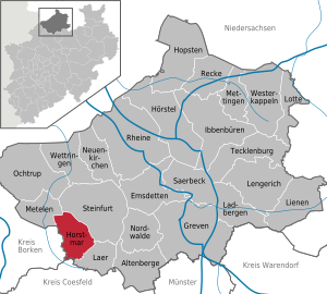
| Location of the city of Horstmar in the Steinfurt district | ||
  |
||

Horstmar ( Low German Huorsmer ) is a small town in the Steinfurt district in the northwest of North Rhine-Westphalia near Münster . Since July 24, 2012 Horstmar has officially been named “ City of Burgmannshöfe ”.
geography
location
Horstmar is located in the Burgsteinfurter Land, which is part of the Münsterland . The distance to the northern district town of Steinfurt is almost ten kilometers, Münster in the southeast is about 30 km away, the Dutch border at Gronau in the northwest is also about 30 km.
Neighboring communities
The area of the city of Horstmar borders on the communities of Schöppingen ( Borken district ), Metelen , Laer (both Steinfurt district ), Rosendahl (Coesfeld district) and the district town of Steinfurt .
City structure

The village of Leer , which was independent until 1969, also belongs to Horstmar . So now belong to the city Horstmar the peasantry Alst , holders , Niedern , Ostendorf and saddle-be .
history
middle Ages
.jpg)
Horstmar Castle was built in the 9th century and was first mentioned in the early 11th century in a book of the Werden Abbey . The town of Horstmar was built south of this castle. The noblemen of Horstmar , who were probably a branch of the von Holte family , are first documented in 1092 as feudal men of the Counts of Cappenberg . The crusader Bernhard the Good stands out among the Lords of Horstmar . His nephew and successor Otto von Horstmar (1227-1246) acquired the rule of Ahaus by marrying Adelheid von Ahaus , which after his death was separated from Horstmar through inheritance and fell to his son Bernhard, while his daughter Beatrix received 1251 Horstmar. She married Count Friedrich von Rietberg , who after disputes had to recognize the suzerainty of the Bishop of Münster and in 1269 sold the Horstmar rule and the castle to the Münster monastery . With that, the rule of Horstmar passed into the prince-bishop's office of Horstmar .
Modern times
The Horstmarer Burg was a favorite seat of the bishops of Münster until the 16th century, and since the 15th century it was developed into a state fortress against the County of Steinfurt . The city was granted rights and freedoms, and the diocese court court also had its seat in Horstmar for a time in the 16th century.
During the Thirty Years' War the castle was destroyed in 1635 on the orders of the Hessian lieutenant Carl von Rabenhaupt . The Horstmar office fell to a line of the Salm family in the course of the Reichsdeputationshauptschluss 1803 . As the county of Salm-Horstmar , the area was an independent territory until it was incorporated into the Grand Duchy of Berg in 1806. In 1815, the area became part of Prussia as a civil rule . In the 19th and 20th centuries Horstmar was an important location for the textile industry , the decline of which hit the city hard.
For the development of the postal system in Horstmar, Leer, Leer-Ostendorf, Loreto and Haus Alst see the postal history of Steinfurt .
Incorporations
On October 1, 1938, the parish parish Horstmar was incorporated. Leer was added on July 1, 1969.
Population development
|
politics
City council
The city council of Horstmar consists of 22 council members and the mayor. In the local elections on May 25, 2014 (or August 30, 2009) the distribution of seats was as follows:
| Party / list | Seats 2014 | % 2014 | Seats 2009 | % 2009 |
| CDU | 12 | 54.7 | 13 | 54.9 |
| SPD | 5 | 24.0 | 4th | 19.5 |
| GREEN | 3 | 11.3 | 2 | 9.3 |
| Independent voter community | 2 | 10.0 | 2 | 10.5 |
| FDP | - | - | 1 | 5.9 |
coat of arms
Blazon : "On a shield ground squared from silver to blue, an erect, gold-armored and gold-crowned red lion."
The lion, which has been used in city seals since the 14th century, is taken from the shield of the noble lords of Horstmar and has been the heraldic animal of the city of Horstmar since the 17th century. The squared shield comes from the seal of the von Leer family from the municipality of Leer, which was dissolved in Horstmar today. Horstmar has had the coat of arms since 1939.
partnership
The city of Horstmar maintained a partnership with the former Dutch municipality of Warnsveld , now a district of the city of Zutphen , from 1991 to 2018 . In the course of austerity measures, the city of Zutphen announced these in 2018.
Culture and sights

The historical core of the city is almost square and was surrounded by eight Burgmannshöfen , four of which, Münsterhof , Merveldter Hof , Borchhorster Hof and Sendenhof have been preserved. Only the basement of the Valkenhof has been preserved. The founding of the Burgmannshöfe goes back to the 11th century. All of them have been rebuilt several times, the oldest in their current form from the 16th century.
The St. Gertrudis Church (beginning of the 14th century) and the Old Town Hall from 1571, a protruding brick building placed on the basement made of quarry stone masonry, bear witness to the city's self-confidence . After the city administration moved in 1963 and underwent thorough renovation, it is now used as a meeting room and wedding room.
Outside the city is the Alst House , first mentioned in a document in 1217 , formerly the seat of the Schorlemer - Alst family . The listed chapel of St. Antonius Abt is also worth seeing .

Castle gate at Sendenhof

.jpg)
.jpg)
.jpg)
Economy and Infrastructure
The structural change in the textile industry in the Münsterland region , which directly affected Horstmar as the headquarters of Schulte & Dieckhoff's largest stocking factory at the time , remained largely without consequences for its economy. The former production and storage halls are now in the hands of various other companies. Schmitz-Cargobull AG, for example, acquired the administration building and set up its representative company headquarters there.
The city has a commercial area in each of the two districts with a total area of around 27 hectares.
The following large, nationally known companies are located in Horstmar:
- Coppenrath Verlag KG Distribution
- Reventa GmbH & Co. KG, plastics processing
- Schmitz Cargobull
traffic
Horstmar is connected to the federal highway 54 between Gronau on the Dutch border and Wiesbaden via the state road L 579 . It also provides a connection to the A 31 between the North Sea coast and the Ruhr area, as well as the A 1 . The district town of Steinfurt in the north can be reached in less than 10 minutes by car via the L 580. The Münster / Osnabrück airport to the east lies some 35 km away and can be reached in 40 minutes by car.
Horstmar is connected to the cycle path 100-Schlösser-Route and cycle path historical town centers.
Horstmar is connected to local public transport via the bus routes S70 (Münster - Winterswijk, NL) and R81 (Steinfurt - Coesfeld) . Both run every hour during the day, more frequently during rush hour. At the weekend the night bus runs on the N6 line.
Personalities
- Bernhard the Good , nobleman and crusader (1170–1227)
- Maximilian-Friedrich von Droste zu Hülshoff (1764–1840), composer, lived and died at Haus Alst and is buried in the cemetery in Leer
- Burghard Freiherr von Schorlemer-Alst , politician (1825–1895)
literature
- Peter Ilisch, Horstmar . Historical Atlas of Westphalian Cities, ed. v. T. Tippach, Vol. 13. Publications of the Historical Commission for Westphalia, New Series 56. Münster 2020, ISBN 978-3-87023-446-1 .
Individual evidence
- ↑ Population of the municipalities of North Rhine-Westphalia on December 31, 2019 - update of the population based on the census of May 9, 2011. State Office for Information and Technology North Rhine-Westphalia (IT.NRW), accessed on June 17, 2020 . ( Help on this )
- ^ Franz Petri , Georg Droege , Friedrich von Klocke , Johannes Bauermann (eds.), Klaus Flink: Handbook of the historical sites of Germany . Volume 3: North Rhine-Westphalia (= Kröner's pocket edition . Volume 273). 2nd, revised edition. Kröner, Stuttgart 1970, DNB 456882855 , p. 343.
- ^ Anton Janßen: Dungeon of the Anabaptists. The Horstmarer Burg was an important fortress for a long time . In: Our circle. Yearbook for the Steinfurt district , vol. 24 (2011), pp. 80–87, here p. 80.
- ^ Anton Janßen: Dungeon of the Anabaptists. The Horstmarer Burg was an important fortress for a long time . In: Our circle. Yearbook for the Steinfurt district , vol. 24 (2011), pp. 80–87, here p. 81.
- ↑ Stephanie Reekers: The regional development of the districts and communities of Westphalia 1817-1967 . Aschendorff, Münster Westfalen 1977, ISBN 3-402-05875-8 , p. 249 .
- ↑ Martin Bünermann: The communities of the first reorganization program in North Rhine-Westphalia . Deutscher Gemeindeverlag, Cologne 1970, p. 96 .
- ^ WDR: Local elections 2009
- ^ Result of city council election Horstmar 2014
- ↑ Burgmannshöfe ( Memento of the original from April 26, 2014 in the Internet Archive ) Info: The archive link was inserted automatically and has not yet been checked. Please check the original and archive link according to the instructions and then remove this notice. on the website of the city of Horstmar
- ↑ Trade & Commerce ( Memento of the original from February 17, 2015 in the Internet Archive ) Info: The archive link was inserted automatically and has not yet been checked. Please check the original and archive link according to the instructions and then remove this notice. on the website of the city of Horstmar, accessed on February 17, 2015
- ↑ Commercial areas ( Memento of the original from February 17, 2015 in the Internet Archive ) Info: The archive link has been inserted automatically and has not yet been checked. Please check the original and archive link according to the instructions and then remove this notice. on the website of the city of Horstmar, accessed on February 17, 2015
- ↑ Transport connection ( Memento of the original from February 17, 2015 in the Internet Archive ) Info: The archive link was inserted automatically and not yet checked. Please check the original and archive link according to the instructions and then remove this notice. on the website of the city of Horstmar, accessed on February 17, 2015
- ^ Münsterland eV: Cycling in Horstmar | Münsterland eV Tourism. Retrieved June 9, 2017 .
- ↑ Bus timetable for the Koppelstraße stop
- ↑ Timetable bus route R81, Steinfurt - Coesfeld
- ↑ Timetable bus line S70, Münster - Winterswijk, NL
Web links
- Website of the city of Horstmar
- Document registers from the Loburg Castle archive with holdings on Horstmar and Nienborg / digital Westphalian document database (DWUD)
- Landschaftsverband Westfalen-Lippe: Green areas in Horstmar in LWL geodata culture
- Horstmar in the Westphalia Culture Atlas
Altenberge | Emsdetten | Greven | Hopsten | Hörstel | Horstmar | Ibbenbueren | Ladbergen | Laer | Lengerich | Lienen | Lotte | Metelen | Mettingen | Neuenkirchen | Nordwalde | Ochtrup | Warrior | Rheine | Saerbeck | Steinfurt | Tecklenburg | Westerkappeln | Competition