
Hops
| coat of arms | Germany map | |
|---|---|---|

|
Coordinates: 52 ° 23 ' N , 7 ° 36' E |
|
| Basic data | ||
| State : | North Rhine-Westphalia | |
| Administrative region : | Muenster | |
| Circle : | Steinfurt | |
| Height : | 40 m above sea level NHN | |
| Area : | 99.82 km 2 | |
| Residents: | 7650 (Dec. 31, 2019) | |
| Population density : | 77 inhabitants per km 2 | |
| Postal code : | 48496 | |
| Primaries : | 05458, 05457 | |
| License plate : | ST, BF, TE | |
| Community key : | 05 5 66 020 | |
| LOCODE : | DE HOP | |
| Community structure: | 3 districts | |
| Address of the municipal administration: |
Bunte Strasse 35 48496 Hopsten |
|
| Website : | ||
| Mayor : | Winfried Pohlmann ( SPD ) | |
| Location of the community of Hopsten in the Steinfurt district | ||
  |
||

Hopsten is a municipality on the northern tip of the Westphalian region of Tecklenburger Land ( Steinfurt district ), and its location makes it the gateway to Westphalia . Since 1975 , the community has included the Töddendorf Hopsten, the districts of Shell and Halverde .
geography
Geographical location
The municipality of Hopsten is located on the northern tip of the Tecklenburger Land and is still dominated by agriculture to this day . The district of Shell protrudes like a spur into the neighboring Lower Saxony , from which the name Gate to Westphalia arose. In the south of the village lies the Heiliges Meer - Heupen nature reserve in a geological subsidence zone . The Emsland connects to the north and west, and the Osnabrücker Land to the east . Due to the location of the community many Hopstener went in earlier times as Hollandgänger to the nearby Netherlands work. In addition, as traveling merchants, the so-called Tödden , they brought goods to the Netherlands. This is how Hopsten received the name that is still used today as Töddendorf .
Landscapes, mountains, rivers

Hopsten is located in the Plantlünner sand plain , a sub-category of the North German Plain . The Lingener Heights and the Ankumer Heights run north of the municipality , a hilly landscape of sand (so-called terminal moraine ) that was heaped up during the Ice Age . The western beginning of the Teutoburg Forest is located on the Huckberg south of the municipal border between Hörstel and Bevergern . To the southwest of the neighboring village of Obersteinbeck , the Ibbenbürener Bergplatte begins with the upstream Kälberberg , with the western Dickenberg and the eastern Schafberg. By mining coal seams at the Karbonhorst, the Ibbenbüren mine was the largest employer in the Hopsten population until 2018.
The Hopstener Aa flows through Hopsten ; this is divided west of Rheiner Straße into the larger Giegel and the smaller Hopstener Aa . The Schaler Aa runs through the northern municipality only through Halverde, where it is still called Halverder Aa ; Downstream in the shell it joins the Wiechholz Aa and flows into another river at Freren , with which it forms the Große Aa . The municipality also runs through the Bardelgraben , which at the same time represents the border between the Hopsten district and the Halverde and Shell districts. The neighboring regions Münsterland and Weser-Ems-Land usual hedgerows are also found in Hopsten. However, they are not arranged in as small a space as in the Münsterland park landscape , but rather loosely scattered between fields.
Neighboring communities
The neighboring communities in Tecklenburger Land are Hörstel , Recke and Ibbenbüren . The neighboring towns of Freren and Schapen are located in Emsland in Lower Saxony , and the municipalities of Fürstenau and Voltlage in the Osnabrück region . Hopsten is considered a sub-center for this rural supply area with fewer than 10,000 inhabitants .
|
Freren 12 km |
Fürstenau 16 km |
Voltlage 12 km |
|
Schapen 4 km |
.svg)
|
Stretch 8 km |
|
Hörstel 7 km |
Ibbenbueren 13 km |
The medium-sized center that is mainly frequented and closest to meet basic and periodic needs is Ibbenbüren . Other medium-sized centers in the area are Lingen (Ems) and Rheine . The city of Osnabrück is the main center of the community of Hopsten and of the entire Tecklenburger Land . Due to the greater distance and poor transport connections, Münster is of little importance as a regional center.
Community structure

Today's structure
| District | surface | Population (December 31, 2017) |
|---|---|---|
| Hops | 48.70 km² | 5301 |
| Halverde | 17.17 km² | 1052 |
| Bowl | 33.95 km² | 1248 |
| total | 99.82 km² | 7601 |
The former Hopsten farmers in Ostenwalde no longer belong to Hopsten, but to Hörstel . Until the end of 1974, the area included the independent municipalities of Halverde, Hopsten and Shell, which belonged to the Hopsten district.
Population development
|
|
|
|
history
Before 1400

Settlement of the area around Hopsten goes back to the Stone and Bronze Ages. The first written evidence comes from the year 890 AD. Several farms belonging to the Staden peasantry are listed in the tax register of the Werden an der Ruhr monastery . The first people settled on the old flute in the areas around the Stadener Esch, Rüschendorfer Esch and Stertesch. Settlement of the southern farmers' communities, Breischen, Börnebrink and Aa, took place only later, as due to the moorland it was only possible to settle on hills (on a "Hop seten").
With the acquisition of the Osnabrück high bailiwick in 1236 by Count Otto I von Tecklenburg , the parish of Schapen and the associated areas of Ostenwald and Stadener Wald became part of the county of Tecklenburg . The name Hopsten was first mentioned in a document in Osnabrück in 1265. There is talk of a Ministerial Fretherich von Hopseten . In 1343 a chapel for the village of Hopsten is already mentioned in a document, for which Count Nikolaus I von Tecklenburg recognizes the patronage and presentation rights of the abbot of Werden.
1400 to 1500
Hopsten belonged to the late 14th century country wonderfully for county Tecklenburg . After a lost war, half of the parish of Schapen with the Stadener Wald and the Ostenwald came on October 25, 1400 : today's Hopsten to the bishopric of Münster . This was the result of ongoing disputes between Count Nikolaus II of Tecklenburg and the powerful neighbors Münster and Osnabrück. Because a chapel already stood on the grounds of the Hopsten district , the place was called dat Kerspel to Hopseten , later called parish Hopsten. The Hopsteners were still part of the parish church of Schapen for around 200 years until Ort became an independent parish .
1648 to 1818
Hopsten is known as Töddendorf . The Tödden were traveling merchants and peddlers who developed from Holland-goers after the Thirty Years' War , with the heyday in the 18th century, and who initially offered their goods in the Netherlands, then also in the Nordic and Baltic countries. The Tödden trade brought some prosperity to the home communities, which the Tödden houses with their often lavishly designed gables, the Anna chapel on the Breischen, the baroque parish church, the many wayside shrines and the monuments that are in all six farmers still testify to this day. The most famous of the Tödden houses is the Nieland house. Around 1750 Hopsten had about 2000 inhabitants, of whom over 200 people are described as "traveling" in the population register, ie as people who earned their money through trade. In 1803 Hopsten joined the Kingdom of Prussia and after Napoleonic rule in 1816, with the founding of the Tecklenburg district, returned to the Tecklenburger Land after a little over 400 years.
1818 to 1900
The end of the traveling trade after 1818 led Hopstens to regress to a purely agricultural community; poverty developed among the rural population. During this time (from 1846 to 1849) the workers and social bishop Wilhelm Emmanuel von Ketteler was pastor of Hopsten. From June 1848 to January 1849 he was a member of the Frankfurt National Assembly . His commemorative speech at the grave of the MPs Auerswald and Lichnowsky , who were killed in the September uprising , made the peasant pastor famous. He was transferred to St. Hedwig's Cathedral in Berlin in 1849 . He later became bishop of Mainz.
1900 until today

The Hopsten Office was merged with the Shell / Halverde Office in Hopsten in 1917, but the municipalities initially remained independent, apart from a joint administration. The administration found temporary accommodation in the rooms of the later post office in the Doeker house until the town hall was completed in 1922. This is located at Bunten Straße 25 and is used today as a residential and commercial building. In the 1960s it became apparent that the old town hall no longer met the space requirements of the office: a new administration was built at Bunten Strasse 35. The old town hall was in the meantime used by the DRK and as a residential building until it was sold in 2010.
The Hopsten office was dissolved on January 1, 1975 as part of the regional reform. The previously independent municipalities of Hopsten, Shell and Halverde, administered by the Hopsten Office, were also united in an enlarged single municipality of Hopsten. These administrative changes, which were connected with the loss of independence for Shell and Halverde, met with complete incomprehension in all three districts.
One of the most serious bus accidents in German history shocked the town on June 18, 2007. A coach crashed on the 14th motorway near Könnern , which was supposed to bring members of the local agricultural association to Dresden . 13 people were killed and 36 injured. At a memorial hour in the parish church of St. Georg on June 19, 2007, numerous people from the town also attended the then Prime Minister of North Rhine-Westphalia, Jürgen Rüttgers , and the regional labor minister of North Rhine-Westphalia, Karl-Josef Laumann , part.

Mine locomotive in Hopsten
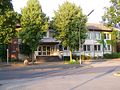
Hopsten town hall
The Veerkamp community center

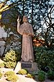
Death statue on the market square
Kettelerdenkmal at the cath. church


administration
from 1400 to 1809 as the parish of Hopsten
- 1400–1803 Bevergern court
- January 1, 1804–1806 Bevergern court, Münsterscher Kreis
- June 1, 1806–1809 Bevergern court, Bevergernscher Kreis
Hopsten as a separate office
- May 20, 1809–1813 Mairie Hopsten (France)
- November 18, 1813–1844 Hopsten mayor's office
- January 4, 1844–1851 Hopsten Office
- May 19, 1851–1856 Hopsten municipality
- March 20, 1856–1974 Hopsten office
- since January 1, 1975 Hopsten municipality

Religions
- Catholic parish of St. Georg, Hopsten
- Catholic parish St. Peter u. Paul, Halverde
- Ev. Recke-Hopsten parish
- Ev. Parish shell
- St. Anne's Chapel in Hopsten
politics
Municipal council
The distribution of seats in the town hall after the municipal elections in North Rhine-Westphalia in 2014 :
mayor
- Winfried Pohlmann (SPD) since 1999
- Former mayors of the entire municipality (from January 1, 1975)
- 1989–1999 Anni Tieke (CDU)
- 1975–1989 Robert Jasper (CDU)
- 1975 Franz Feldmann (CDU) (died after a short term in office)
- Former Mayor of Hopsten Municipality (until December 31, 1974)
- 1969–1974 Robert Jasper (CDU)
- 1964–1969 Rudolf Rost (CDU)
coat of arms
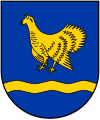
The coat of arms of the municipality shows the Hopstener Tödden and the Halverder black cock, which are spatially separated by the Schaler Himmelsleiter.
Blazon : “In green a silver sloping ladder, accompanied in front by a silver black grouse looking to the left, behind by a silver man in a frock coat, with knee breeches, hat and black buckled shoes, on his back a silver box, in his right hand one silver stick, in the left hand a silver pipe. "
This represents the typical traditional clothing of a Hopstener Tödden. It is still worn today at official community events.
Coat of arms of the Hopsten districts: (before 1975)
Halverde

Hops
Bowl


_COA.svg)
Community partnerships
Hopsten has two community partnerships. The municipality of Lychen in the Uckermark (Brandenburg) and Noves in the Bouches-du-Rhône department in France.
Culture and sights
Buildings
Parish Church of St. George

The St. Georg Church in Hopsten is a three-aisled church that was built according to baroque principles . The first chapel in Hopsten was mentioned in 1343 in a document from Count Nikolaus von Tecklenburg . At that time, this chapel still belonged to the parish of Schapen . Nothing is known about the size of the chapel. At the beginning of the 16th century, the church was built at its current location at the latest. It was a single-nave Gothic church halfway up the current church. Parts of this church can still be found in the church today. In 1538 the Hopsten church was detached from the parish of Schapen. At the latest in 1541 with the beginning of the Reformation in Schapen, Hopsten was finally detached from it. When Hopsten had become prosperous through the death trade , today's baroque three-aisled hall church was built over the small church from 1732 to 1734 . In 1749 the tower of the church was raised and got its baroque dome. In 1867 the baroque parts were removed from the church as they no longer corresponded to the fashion of the time. This happened on the initiative of the Bishop of Munster . A neo-Gothic choir was added. The furnishings were replaced by neo-Gothic objects. These changes were reversed with a renovation in 1955. In 1981 and 1982 the church was completely renovated inside and out.
Pilgrimage chapel of St. Anna

The St. Anna Chapel is a place of pilgrimage of the Münster diocese in the Breischen farmers' community in Hopsten. The chapel was built in 1694 and expanded several times as it could no longer contain the influx of pilgrims . The initiative to build the chapel went back to the brothers Johann and Dietrich Teeken. The two dead were caught in a storm while on a boat trip on a trade voyage. Thereupon they swore to build a chapel in honor of the figure of the Holy Mother Anna, if they would survive this storm. This figure of the Holy Mother Anna was stolen from the tree in 1677 when an oak tree was felled at the current location of the chapel. It is said to have been lying in the attic of the neighboring farmer for years. One story goes that all sorts of mischief was being done with this figure at a party when suddenly all the windows in the house burst. At the site of the chapel there is now also a pilgrimage site and a cross with a park.
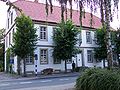
House Nieland

Haus Nieland, also called Poggeburg , is one of the oldest preserved buildings in Hopsten. The age of the house is not dated. The oldest piece of evidence dates back to 1734. However, this relates to the side wing that was added. According to Wilhelm Vershofen , chronicler of the house, the beginnings of the house go back to the Carolingian era. It is said to have been a moated castle, manor house and even a rectory. The wealthy Tödde Hermann Poggemann (* 1680) wanted to build a house like a castle. So he added the mentioned side wing. An old defense tower was simply integrated into the house.
After the death of the tödden trade, the house went to the Nieland family, whose name it still bears today. The two poets Wilhelm Vershofen and Josef Winckler , who were related or related by marriage to the Nielands, founded the Association of Workers on House Nyland in 1912 . They met from time to time in the blue drawing room of the house. Other poets who belonged to the Bund were: Heinrich Lersch , Jakob Kneip , Karl Bröger , Gerrit Engelke and Carl Maria Weber . The artist association existed until 1925. In the 1950s, then Minister of Economics Ludwig Erhard , a friend of Verhofen, visited the house. Today the house is an inhabited museum, in which the time of the Tödden and the Dichterbund comes to life again.
Natural monuments
- Holy sea

The Heiliges Meer - Heupen nature reserve is the best-known nature reserve in the municipality of Hopsten. It is 5 km south of the town center on the road to Ibbenbüren. With the Recker portion, the nature reserve comprises a total of 260 hectares of nature reserve. These range from heather to alder forest to swamp areas. The main attractions of the nature reserve are the Great Sacred Sea , the Small Sacred Sea , the sinkhole lake and the heather ponds . Except for the Heideweiher, these lakes were created by sinkholes.
- Brockmöller's oak
On the farm of the farmer Brockmöller on the road to Recke, just before the municipality border, there is the tree, popularly known as " Brockmöler's thick oak ". It has already been examined several times, its age was estimated at 700 years in 1904 (i.e. over 800 years today). Even then, the tree had a crown diameter of 27 m at a height of 25 m. The circumference of the trunk was 7.5 m. It has been on the list of notable trees since 1926. The chest height is 8.71 m (2014).
- The Hopsten yew trees
In the center of Hopsten there are four yew trees that are said to be very old. In the garden of the Withake house, which was mentioned as an inn in 1500, there is one of these trees, which is estimated to be 600 years old. When this yew was added to the list of notable trees in 1926, it measured 12 m in height, had a 12 m wide crown and a circumference of 1.88 m.
There are more yew trees between the houses on Marktstrasse and two by the church. If the estimated age of the trees of 600 years is correct, they should have been planted around 1400 when Hopsten became self-employed.
- Offices
The Koffituten is an intact high moor in the district of Shell . It is one of the few intact raised bogs in North Rhine-Westphalia and the only living one in the Steinfurt district.
Regular events

- Halverder Schützenfest on the 3rd weekend in July
- Hopstener Kirmes 1st weekend in October
- Hopsten Christmas Market 4th Sunday in Advent
Halverder Balloon Festival

The Halverder Ballon Festival takes place every two years in September. From Thursday to Sunday, up to 25 hot air balloons are represented on the Halverde West sports field. In 2012 the festival took place for the fourth time. A special highlight are the balloon glow and the early start at dawn.
St. Anne's Week
St. Anne's Week takes place every August as a week of faith. It has an annually changing theme and ends with a Sunday procession from the parish church of St. Georg to the Anna Chapel on the Breischen, where it ends in a final service with more than 1000 participants. Every year, the Annenwoche attracts several thousand people, especially from the Münsterland, Emsland and Ruhr area.
Economy and Infrastructure
traffic
Transportation
Due to its proximity to Lower Saxony , Hopsten is served by the buses of Regionalverkehr Münsterland and the Emsland-Süd transport association in local public transport . There is a regular taxi bus connection from Hopsten to Recke with a connection to the bus from Recke to Osnabrück. The Tecklenburger Nordbahn freight train runs to the east in the Obersteinbeck district of Reck and to the south near the Ostwalde farms in Hörstel . The disused Duisburg – Quakenbrück railway runs west of the Hopsten municipality . There is therefore no direct connection between local public transport and a railroad.
Road traffic
Federal motorway 30 is located south of Hopsten near Hörstel . Through this Hopsten is only 10 km away from the European trunk road system.
Due to the boiler construction company Josef Jasper in Hopsten, there are often heavy transports through the middle of the narrow historic town center. This attracts many interested people from the area and often has almost a festival atmosphere. Many lamps and traffic signs in Marktstrasse and Kettelerstrasse are already geared towards heavy haulage or can easily be dismantled.
The town's two roundabouts are also specially designed for heavy haulage, because another company from the neighboring town of Schapen often uses Hopsten to handle transports for the company from Hopsten .
Shipping
The Mittelland Canal is also located in the neighboring village of Obersteinbeck . Through it, bulk goods can be transported cheaply to the vicinity of the municipality.
air traffic
The nearest passenger airport is Münster / Osnabrück Airport in Greven. The located on site Airfield is a former military airfield .
commuter
Hopsten is a classic out-commuter community in which significantly more people commute than in. In 2015, the number of out-commuters was 2,909 and the number of in-commuters was 1,101. The most important places of work for the Hopsten population are Ibbenbüren, Rheine and Recke. In addition to the commuters, 1,246 Hopsten citizens are also employed locally, which results in a total of 2,347 social security employees. The mining process with the associated closure of the Ibbenbüren mine has not yet found a decline in the figures and will only be noticeable in the coming surveys.
Commuters
| workplace | 2013 | 2014 | 2015 |
|---|---|---|---|
| Ibbenbueren | 638 | 638 | 641 |
| Rheine | 328 | 351 | 341 |
| Warrior | 229 | 227 | 234 |
| Hörstel | 210 | 209 | 208 |
| Spelle | 171 | 172 | 170 |
| Osnabrück | 124 | 138 | 130 |
| Muenster | 115 | 125 | 122 |
| Schapen | 89 | 75 | 76 |
| Lingen | 87 | 87 | 87 |
| Mettingen | 79 | 78 | 84 |
Commuters
| place of residence | 2013 | 2014 | 2015 |
|---|---|---|---|
| Ibbenbueren | 194 | 215 | 195 |
| Warrior | 160 | 180 | 192 |
| Rheine | 89 | 90 | 96 |
| Hörstel | 88 | 92 | 98 |
| Fürstenau | 46 | 56 | 52 |
| Schapen | 38 | 41 | 45 |
| Spelle | 28 | 33 | 31 |
| Mettingen | 28 | 39 | 43 |
| Lingen | 25th | 22nd | 22nd |
| Westerkappeln | 20th | k. A. | k. A. |
| Freren | k. A. | 21st | 28 |
Modal split
The modal split describes the proportions in the selection of means of transport for passenger transport in the municipality of Hopsten. Due to a similar structure in the municipalities of Mettingen, Recke and Hopsten, they were examined together
| Means of transport | on foot | bicycle | Public transport | Vehicle | year |
|---|---|---|---|---|---|
| proportion of | 8th % | 23% | 4% | 64% | 2011 |
Established businesses
Several metal construction companies are based in Hopsten. The best-known of all companies is the G&W Jaspers candle factory. She mainly produces candles for church use, but also for other uses. It was founded by Heinrich Jaspers in 1864 on the initiative of the Social Bishop of Mainz, Wilhelm Emmanuel von Ketteler .
media
- Ibbenbüren People's Newspaper
- The Osnabrück Sunday newspaper appears weekly on Sundays
education
In Hopsten there is the St. Franziskus Elementary School with the two secondary locations Halverde and Shell. The secondary locations are so-called dwarf schools .
Further education branches in Hopsten are:
- St. Georg secondary school
- Hüberts'sche Schule , state-recognized private school with secondary school and upper secondary school
The Ketteler Realschule expired on June 28, 2019 and was closed. Since the Hüberts'sche Schule began operating secondary schools in 2014, there is still a secondary school on site.
Personalities
Sons and daughters of the church

- Karl Heinrich Brüggemann (1810–1887), journalist, fraternity member and activist at the Hambach Festival
- Bernhard Otte (1883-1933) was a Christian trade union leader
- Sister Maria Euthymia Üffing (1914–1955), on October 7, 2001 beatified Clement sister
- Christel Schulz (1921–2014), track and field athlete , was the first woman in the world to jump over six meters in the long jump in 1939
- Wienhold Gernemann (1926–2009), sculptor
- Franz-Josef Kemper (born September 30, 1945), track and field athlete, Olympic participant and functionary
- Dieter Frekers , nuclear physicist
- Dieter Jasper (born November 29, 1962), politician, 2009-2013 member of the Bundestag (CDU)
Personalities who have worked in the place
- Wilhelm Emmanuel von Ketteler (born December 25, 1811 in Münster , † July 13, 1877 in Burghausen , Altötting district ), the later “social bishop” and German politician ( Center Party ), was pastor in Hopsten from 1846 to 1848 .
- Josef Winckler (born July 7, 1881 in Bentlage near Rheine, † January 29, 1966 in Bensberg) was a Westphalian writer.
- Wilhelm Vershofen (born December 25, 1878 in Bonn, † April 30, 1960 in Tiefenbach) was a German economist, politician (DDP) and writer.
- Alexander von Stahl (born June 10, 1938 in Berlin), lawyer, politician (FDP), Federal Prosecutor General 1990–1993, grew up in Hopsten
literature
- Josef Winckler : Pumpernickel. Fates and characters around house Nyland . Collected Works, Volume 5. Commissioned by the Nyland Foundation, Cologne, edited by Hans Günther Auch. Lechte, Emsdetten 1993, 452 pages, ISBN 3-7849-1166-8 .
- Georg Hagemeier, Alfons Tepe: Hopsten in pictures . Published by the Ibbenbürener Volkszeitung. Ibbenbürener Volkszeitung, Ibbenbüren 1987, 104 pages, ISBN 3-921290-28-7 .
- Gertrud Althoff: We just have to remember. History of the Jewish Hopstener . Self-published by Gertrud Althoff, Rheine 2003, 50 pp.
- Heinrich Hopster: Hopsten. Past and present . Published by the municipality of Hopsten, Hopsten 1974, 136 pp.
- Author collective: Hopsten in old views . The back row. European Library, Zaltbommel / Netherlands 1997, 76 pages, ISBN 90-288-6409-1 .
- Christa Tepe: Hopsten - A village on the border . Published for the 600th anniversary of the Hopsten community in 2000.
Web links
- Website of the municipality of Hopsten
- Hopsten in the Westphalia Culture Atlas
Individual evidence
- ↑ Population of the municipalities of North Rhine-Westphalia on December 31, 2019 - update of the population based on the census of May 9, 2011. State Office for Information and Technology North Rhine-Westphalia (IT.NRW), accessed on June 17, 2020 . ( Help on this )
- ↑ Diether Stonjek: Hopsten In: lwl.org , accessed on December 7, 2017 (PDF; 4.86 MB)
- ↑ a b c d e f g h Men are slightly in the majority In: IVZ , January 9, 2014
- ↑ a b c d e f g h i j k l m n o p Population development: Figures have been falling again since 2015 In: IVZ , February 7, 2018
- ↑ Archive link ( Memento of the original dated May 2, 2014 in the Internet Archive ) Info: The archive link was inserted automatically and has not yet been checked. Please check the original and archive link according to the instructions and then remove this notice. Hopsten tourist office - history of the Hopsten community
- ↑ Timeline in: st-georg-hopsten.org , accessed on December 7, 2017.
- ↑ Christa Tepe (red.) Et al .: Shell. A village introduces itself . Pp. 138-140. Loss of official seat
- ^ Federal Statistical Office (ed.): Historical municipality directory for the Federal Republic of Germany. Name, border and key number changes in municipalities, counties and administrative districts from May 27, 1970 to December 31, 1982 . W. Kohlhammer, Stuttgart / Mainz 1983, ISBN 3-17-003263-1 , p. 318 .
- ↑ Christa Tepe: Hopsten - A village on the border. Published for the 600th anniversary of the Hopsten community in 2000. pp. 206–208 on the origins of the entire community
- ↑ Municipal council election 2014 on Hopsten.de ( page no longer available , search in web archives ) Info: The link was automatically marked as defective. Please check the link according to the instructions and then remove this notice. (accessed January 12, 2015)
- ↑ https://www.ivz-aktuell.de/Artikel/81443/Lokales/Hopstens-Altbuergermeister-verstorben IVZ on January 4th, 2016: "Hopstens Old Mayor died"; accessed on March 27, 2018
- ↑ https://archiv.ivz-aktuell.de/index4.php?id=19352&pageno=15 IVZ on May 23, 1975: "Franz Feldmann is the new mayor of Hopsten"; accessed on March 27, 2018
- ↑ https://archiv.ivz-aktuell.de/index4.php?id=22492&pageno=27 IVZ on October 25, 1985: "Ex-Mayor Rudolf Rost †"; accessed on March 27, 2018
- ^ Entry in the directory of monumental oaks . Retrieved January 10, 2017
- ↑ Halverder Ballon Festival In: ballonsportfreunde-halverde.de , accessed on December 7, 2017.
- ↑ Official website of the municipality of Hopsten. ( Memento of the original from June 13, 2015 in the Internet Archive ) Info: The archive link was inserted automatically and has not yet been checked. Please check the original and archive link according to the instructions and then remove this notice.
- ↑ Johannes Bernard: The St. Anna Chapel in Hopsten-Breischen In: Church + Life from May 22, 2010
- ↑ Commuter Atlas North Rhine-Westphalia for Hopsten In: pendleratlas.nrw.de , accessed on December 7, 2017.
- ↑ Mobility behavior 2011 In : kreis-steinfurt.de accessed on December 7, 2017 (PDF; 1.62 MB, p. 34)
- ↑ Anke Beiing: The end of the Ketteler secondary school: "Something melancholy resonates". In: ivz-aktuell.de. Ibbenbürener Volkszeitung , June 6, 2019, accessed on July 20, 2020 .
Altenberge | Emsdetten | Greven | Hopsten | Hörstel | Horstmar | Ibbenbueren | Ladbergen | Laer | Lengerich | Lienen | Lotte | Metelen | Mettingen | Neuenkirchen | Nordwalde | Ochtrup | Warrior | Rheine | Saerbeck | Steinfurt | Tecklenburg | Westerkappeln | Competition