Huckberg
| Huckberg | ||
|---|---|---|
|
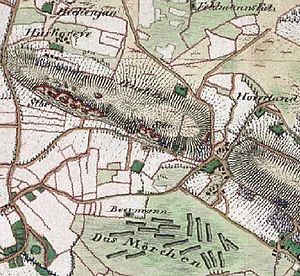
The Huckberg around 1850, several quarries are shown on the map |
||
| height | 96 m above sea level NHN | |
| location | Bevergern ( Germany ) | |
| Coordinates | 52 ° 16 '48 " N , 7 ° 36' 5" E | |
|
|
||
| particularities | Beginning of the Teutoburg Forest | |
The Huckberg is north of Bevergern between Rheine and Osnabrück in the Osning sandstone range . It forms the western end of the Teutoburg Forest with a height of 96 m above sea level. NHN .
Location and history
It is separated from the rest of the Teutoburg Forest by the Mittelland Canal . The Dortmund-Ems Canal runs directly to the south . The wet triangle is in the immediate vicinity. The term Gravenhorster Schlucht has established itself as the name of this separation. Two layers of rock come to light here, the Osning Sandstone Range (Lower Cretaceous Period ) and the Skirmish Range (Upper Cretaceous). In the past centuries, different ways of writing have emerged: Huckesberg, Hukesberg, Huxberg or Huk, which means something like "outstanding hill".
Quarries
The quarry located on the southern slope was first mentioned with the construction of the St. Dionysius parish church in Rheine in 1480 and was called the church pit. In 1544 the ramparts of Rheine were built with stones from "steinkulen up den Huckesberge". Other important structures followed in Rheine: the stone Emswehr in 1550 and the first stone Emsbrücke in Rheine in 1675 . In 1767 there were plans to make the Hemelter Bach navigable in order to be able to transport the stones from Huckberg more easily. From 1486 the Huckberg was listed several times in the register of the Gravenhorst monastery . A salt spring was discovered on the north side in 1577 . This was followed by the construction of a salt works , which was named Salzwerk 'Zur Gottesgabe' or Hermannshall.
The Niemann family of builders and stonemasons worked in Bevergern from 1694 to 1859. She was in possession of the quarry at Huckberg. In 1894 this was sold to the Royal Canal Commission for the construction of the Dortmund-Ems Canal and is still owned by the Waterways and Shipping Office today. The quarry was shut down before the start of World War II .
|
Witch cave
On the Huckberg there is a 27.4 m long, continuously accessible cave. The cave running in the sandstone was enlarged in parts by human hands. The origin of the name is derived from a legend about a Walpurgis Night observed there . A special feature of the Hexenhöhle are worm-like clay deposits, so-called vermiculations .
|
swell
- Hans Morlo: Caves and rock formations in the northern Teutoburg Forest - from the "wet triangle" to the hill. on: stadtmuseum-ibbenbueren.de Retrieved on September 19, 2010.


