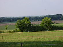
Ankumer height
The Ankumer Höhe , also called Fürstenauer Berge or Bippener Berge , is one to 142 m above sea level. NHN high ridge in the north German lowlands in the district of Osnabrück in Lower Saxony ( Germany ); to the west is the district of Emsland and to the north the district of Cloppenburg . The ridge is about 20 km long and only a few kilometers wide.
geography

location
The Ankumer Höhe is located about 18 km northwest of the medium- sized town of Bramsche near Osnabrück - between Ankum in the east and Fürstenau in the west and between mountains in the northwest and Alfhausen in the southeast. The southeastern foothills of the ridge, which lies in the north-western part of the TERRA.vita nature and geopark (formerly the Northern Teutoburg Forest-Wiehengebirge nature park), extend almost to the Alfsee near Alfhausen . The landscape of the ridge leads from the district of Osnabrück to the northwest in the district of Emsland with Herzlake there and to the north in the district of Cloppenburg with Löningen there .
Neighbors of the Ankumer Höhe are: the Oldenburger Münsterland in the northeast, the Dammer Berge in the east-southeast, the Gehn ridge in the southeast and beyond it the west-northwest foothills of the Wiehengebirge , the Tecklenburger Land in the south and beyond it the northwest foothills of the Teutoburg Forest . In addition, the Lingener Höhe in the west-south-west and the Hahnenmoor in the north-west join with the Hümmling ridge in the north-west, all three of which are located in the Emsland .
geology
The Ankumer Höhe is part of an ice age terminal moraine from the earlier glaciation of the Saale Ice Age , the Drenthe I stage. To this as Rehburger phase designated ice stage , which can be dated to around 230,000 years before present, include the Lingen Heights , the Dammer Berge , the Kellenberg and Brelinger mountain, but not rehburg hills on Steinhude . Together with its almost symmetrical counterpart, the Dammer Mountains on the other side of the Hase valley, the Ankumer Höhe traces the most striking glacier globe of this ice-edge location; this Bersenbrück-Dammer terminal moraine arc filled the lowland bay of the Artland .
Natural allocation
The natural area of the Ankumer Höhe is assigned as follows:
-
(to 58 Dümmer-Geestniederung )
-
(to 585 Bersenbrücker Land )
-
(for 585.0 Bersenbrück-Dammer terminal moraine arch )
- 585.00 Bippener Berge (= Ankumer Höhe; western arc)
- 585.01 Ankumer Flottsand area (southern eastern roof of the Bippen mountains near Ankum and south of it)
- 585.02 Suttruper Sander (middle eastern roof of the Bippen mountains near Kettenkamp and Nortrup - Suttrup )
- 585.03 Dammer Berge (eastern arc)
- 585.04 Holdorfer Sander (northwestern roof of the Dammer Mountains near Holdorf , reaching south to Neuenkirchen )
- 585.05 Dammer Flottsand- und Sandergebiet (south-east roofing of the Dammer Mountains near Damme )
-
(for 585.0 Bersenbrück-Dammer terminal moraine arch )
-
(to 585 Bersenbrücker Land )
Artland (585.10), the core landscape of the Quakenbrück basin (585.1), lies between 585.02 and 585.04 , the south of which separates the western and eastern wings at the valley of the Hase near Bersenbrück .
Surveys
The elevations of the Ankumer Höhe include - sorted by height in meters (m) above sea level (MSL; unless otherwise stated according to):
|
|
Flowing waters
The rivers in and near the Ankum include:
- Hase , passes the Ankumer Höhe in the east, eastern tributary of the Ems
- Fürstenauer Mühlenbach, rises in the central part of the Ankumer Höhe, eastern tributary of the Deeper Aa in the catchment area of the Große Aa
- Ueffelner Aue , rises in the southeast of the Ankumer Höhe, southwest tributary of the Hase
- Weeser Aa , rises in the southeast of the Ankumer Höhe, upper reaches of the Halverder Aa in the catchment area of the Große Aa
Localities
|
In the Ankumer Höhe and in the north-western part of the nature and geopark TERRA.vita are these localities :
|
These localities are located near Ankumer Höhe and the north-western part of the surrounding nature park:
|
history
Some barrows show that the Ankumer Höhe was settled in prehistoric times.
Transport links
The Ankumer Höhe can be reached via the federal roads 68 , which passes the ridge to the east, 218 , which runs along the southwestern edge of the ridge, 214 , which crosses it in a west-east direction, and 402 , which runs west of the Ankumer Höhe, as well as the state and district roads branching off from these roads .
Individual evidence
- ↑ a b Topographic map with the Ankumer Höhe ( memento of the original from February 22, 2016 in the Internet Archive ) Info: The archive link was inserted automatically and has not yet been checked. Please check the original and archive link according to the instructions and then remove this notice. (DTK 25; for heights according to the top contour lines see large enlargement of the map), on natur-erleben.niedersachsen.de
- ^ Sofie Meisel: Geographical Land Survey: The natural spatial units on sheet 70/71 Cloppenburg / Lingen. Federal Institute for Regional Studies, Bad Godesberg 1959. → Online map (PDF; 7.0 MB)
- ^ Sofie Meisel: Geographical Land Survey: The natural space units on sheet 83/84 Osnabrück / Bentheim. Federal Institute for Regional Studies, Bad Godesberg 1961. → Online map (PDF; 6.4 MB)
- ↑ a b c d e f g Map services of the Federal Agency for Nature Conservation ( information )
