
steinhuder sea
| steinhuder sea | ||
|---|---|---|

|
||
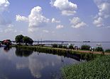
| Steinhuder Meer from the south bank with Wilhelmstein Island | ||
| GKZ | DE: 49811 (with Steinhuder Meerbach to Nordbach) | |
| Geographical location | NW of Hanover | |
| Tributaries | Winzlarer Grenzgraben | |
| Drain | Steinhuder Meerbach → Weser | |
| Islands | Wilhelmstein , Steinhude bathing island | |
| Places on the shore | Steinhude , Mardorf , Hagenburg , Großenheidorn | |
| Location close to the shore | Neustadt am Rübenberge , Rehburg-Loccum , Wunstorf | |
| Data | ||
| Coordinates | 52 ° 28 '20 " N , 9 ° 19' 48" E | |
|
||
| Altitude above sea level | 38 m | |
| surface | 29.1 km² | |
| length | 8 kilometers | |
| width | 4.5 km | |
| volume | approx. 0.042 km³ | |
| scope | 22 km | |
| Maximum depth | 2.9 m | |
| Middle deep | 1.35 m | |
| Catchment area | 82.56 km² | |
|
particularities |
largest lake in Lower Saxony |
|

|
||
| Location of the Steinhuder Meer in Germany | ||

The Steinhuder Meer in Lower Saxony is the largest lake in northwest Germany with an area of 29.1 km² . The maximum depth of 2.9 m and an average of 1.35 m was formed in a basin towards the end of the last ice age about 14,000 years ago. Today, the lake, located about 30 km northwest of Hanover , as the center of the Steinhuder Meer nature park, is a supraregional excursion destination due to its protected natural areas and diverse recreational opportunities. It is located in the Weser river system .
Emergence
The Steinhuder Meer was formed in a bottom basin after the last ice age, the Vistula glaciation, around 14,000 years ago. At that time the inland water was about three times as large, which can be seen today in the moored peripheral areas. Due to the shallow water, it was already silting up at that time. The largest border moor is the Dead Moor , which separates the lake area from the lower terrace of the Leine flowing further east . The water depth averages 1.35 m, at the deepest point 2.9 m. The lake floor has a small area with gullies up to 2.5 m deep. They are called Deipen (depths) and run north of the center of the lake in an east-west direction. On the lake bed, and particularly to the silted edges towards found in different thickness muds , the dead by Zersatz plants (algae) and animals (fleas, crayfish) arise. The mud deposits also make the lake water cloudy, as they are easily whirled up by waves.
Geological studies in the 1960s have shown that the sediments under the Steinhuder Meer contain the remains of a predecessor lake from the Eem warm period around 100,000 years ago.
location and size
The lake is located in the area of the city of Wunstorf , but with its west and north banks it also borders Neustadt am Rübenberge in the west of the Hanover region . Other cities in the vicinity are Hanover, Rehburg-Loccum and Stadthagen . The places Mardorf , Großenheidorn , Steinhude , Hagenburg and Winzlar are in the immediate vicinity of the shore . The lake is located in the large landscape of Hannoversche Moorgeest , to the east it borders the Dead Moor . A 1.2 km long branch canal leads from Hagenburg Castle to the lake.
The area of the lake covers about 29.1 km² depending on the water level, it is 8 km long and 4.5 km wide.
The above-ground catchment area of the lake, including the lake area itself, measures 82.56 km². However, roughly as much is lost on the water surface through evaporation as precipitation falls on the lake. Above all, however, the underground catchment area is much larger than the one above ground; According to an estimate by the Lakes Competence Center of the Lower Saxony State Agency for Water Management, Coastal and Nature Conservation ( NLWKN ), at least 60% of the water input comes from the groundwater , especially from the south and east. Some underwater source locations are known, a systematic record is still pending. The largest above-ground tributary is the Winzlarer Grenzgraben from the Rehburg Mountains . The second tributary on the south side is the Windhorngraben. The only outflow from the Flachsee to the Weser is the Steinhuder Meerbach . The water level can be regulated here via a weir. According to the current operating plan of the Steinhuder Meer, the water level - provided there is sufficient water - should not exceed 37.80 meters above sea level. NN and 38.05 meters above sea level NN fluctuate. Since 2018, the minimum has not even been reached at times.
Protected areas
Due to its importance for species, nature and landscape protection, both the Steinhuder Meer and its surroundings are protected by various instruments. There are several observation towers for observing nature.
Nature reserves
Areas around the Steinhuder Meer are protected by four nature reserves.
- Hagenburger Moor since July 5, 1962
- Meerbruchswiesen since December 10, 1998
- Sea break since June 25, 1981
- Dead moor since May 27, 2016
Landscape protection area
Lake Steinhude is since 25 June 1981, a conservation area .
Fauna-flora habitat area
The FFH area Steinhuder Meer (with border areas) with the area number 3420-331 has an area of 5,371.31 hectares. It is a large flat lake in a complex with extensive natural silting zones and partly intensively, partly extensively used grassland on fens and - mostly through Impaired peat extraction - raised bog areas.
The habitat types are protected :
- Renatured degraded raised bogs
- Transitional and swinging lawn bogs
- Peat bog -Schlenken with beak rushes societies
- Swamps and reeds with edge
- Living raised bogs
- Moist tall herbaceous vegetation
- Lean, lowland hay meadows
- Old acidic oak forests on sandy soils with English oak
- Bog forests
- Natural and near-natural nutrient-rich still waters with spawning or frog-bite communities
- Dystrophic still waters
The appendix II species are protected : crested newt , stag beetle , wolffish (fish) , mud whip , pond bat and blue-tailed damsel .
Be protected Annex IV species : tree frog , spadefoot , moor frog , bog orchid , smooth snake and sand lizard .
Bird sanctuary
The Steinhuder Meer bird sanctuary with the area number 3521-401 has an area of 5,327.00 ha. It is a wetland of international importance, especially for water bird species , and an important bird habitat for breeding bird species in extensive reed beds and undisturbed forest areas.
Natural park
The Steinhuder Meer is the core of the Steinhuder Meer Nature Park , which has existed in this size since October 19, 2011.
Islands
The natural Crow Island on the west bank becomes a peninsula when the tide is low . In the east there are several peat islands in front of the Dead Moor; some have been separated by canals.
The two artificial islands are much better known :
- Wilhelmstein Island as an island of 12,500 m², laid out between 1761 and 1765, the fortress was built from 1765 to 1767.
- Steinhude bathing island as a 35,000 m² island with a wide sandy beach, laid out in 1975 on the south bank of the lake. It was raised from the sand of the Steinhuder Meer and can only be reached by pedestrians via a bridge. The bathing island has a futuristic service center that is powered by solar energy.
history

It is known from archaeological finds that the area around the Steinhuder Meer was inhabited as early as the Paleolithic . The reason could have been the abundance of fish in the water. The lake has belonged to the Grafschaft Schaumburg since the 12th century . Remains of the Kranenburg castle, which was destroyed in a feud in 1320, are believed to be on the lake bed near Steinhude . In the 16th century a map reads “Steinhüer Meer”. Divers found stone remains as early as 1982, and in August 2009 an archaeological investigation using geomagnetics , sonar and radar took place. From 1761 to 1767, Count Wilhelm zu Schaumburg-Lippe had an island built up in the lake and the Wilhelmstein Fortress built on it. In the 19th century and the beginning of the 20th century there were considerations to drain the lake and convert the lake bed into agricultural land. Tourism on the Steinhuder Meer became more important after the Steinhuder Meer Railway opened at the end of the 19th century.
The Steinhuder Meer originally belonged to the Princely House of Schaumburg-Lippe and was located in the principality of the same name . However, after the November revolution of 1918/19, the prince ceded half of it to the new Free State of Schaumburg-Lippe to prevent expropriation . After the Second World War , the Domina division contract was the basis, which ideally left half of the lake in ownership to the former Princely House of Schaumburg-Lippe , based in Bückeburg . This is a consequence of the inclusion of the state of Schaumburg-Lippe in the state of Lower Saxony after the Second World War and the subsequent territorial reform . The Schaumburg-Lippers still own the island of Wilhelmstein. With the territorial reform of 1974, the remaining half of the Steinhuder Meer was sold by the prince to the district of Hanover at a price of DM 5 million .
Culture and tourism


With around two million visitors annually to cities in the surrounding area, especially the state capital Hanover, the Steinhuder Meer is of outstanding importance for local recreation . It is a typical destination for day trips and short breaks. With around 300,000 overnight stays a year with an average of two to three days, the significance for the main vacation is rather minor. There is a high proportion of long-term campers, boat and holiday home owners from the local population. Numerous water sports enthusiasts come from the region to sail, surf and paddle.
The Steinhuder Meer offers visitors a wide range of leisure activities. A more than 35 km long circular hiking and cycling path with observation towers around the lake gives insights into the lake and moor landscape with wet meadows and alluvial forests . Bathing in the lake is possible on the sandy beach of the Steinhude bathing island and on the north bank. In Steinhude and Mardorf there is one motorhome parking space each, and in Mardorf there are several campsites. There are opportunities for sailing, surfing, rowing, paddling and pedal boating on both banks. Due to the high number of visitors, there is a wide range of restaurants around the lake. Visitor attractions are the insect museum , the Steinhuder Meer nature park center and the Steinhude fishing and weaving museum with a toy museum in Steinhude and the dinosaur park in nearby Münchehagen . The ecological protection station in Winzlar regularly offers information and guided tours for nature lovers.
A culinary specialty of the Steinhuder Meer is the Steinhuder smoked eel ; even if not all eels on offer come from the Steinhuder Meer. Occasionally they are still fished traditionally with the Steinhuder peat barge . The Steinhuder Hecht, on the other hand, was the first diving boat in Germany and was launched in the lake in 1772.
Since June 2013 there has been a floating stage on the Steinhuder Meer, which has been heading for five different berths in the summer months. It is intended to illustrate the strong connection between nature and culture at the Steinhuder Meer. The project was realized through the “Integrated Rural Development Concept” (ILEK) of the cities of Wunstorf and Neustadt a. Rbge.
The Steinhuder Meer is served by the bus routes of the Greater Hanover Transport . The nearest train stations are Wunstorf, Poggenhagen and Neustadt am Rübenberge .
Steinhude beach promenade
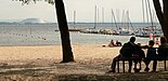
Sandy beach on the north bank, on the left the potash heap of Bokeloh, nine kilometers away

Wilhelmstein Island
Frozen Lake, 2012


water sports
Motor boats are not permitted on the Steinhuder Meer (with the exception of electric motor boats and water rescue motor boats). There are around 5000 sport and sailing boats on the lake. It is relatively suitable for sailing , as its size and oval shape guarantees fair wind conditions, especially for regattas . Land coverage of the wind is almost completely negligible here. However, the increasingly frequent shoals are a problem for boats with a plug-in sword and for keel yachts . If the lake freezes over, ice sailing is possible on it .
An average of 40 regatta series take place on the lake each year, which are organized under the auspices of the Steinhuder Meer Race Association (WVStM). 24 adjacent sailing clubs have been organized in the sailing association since around 1960. On average, one to three German championships and sometimes also European championships in several boat classes are sailed out each year.
In addition, the Steinhuder Meer on the north shore offers the possibility of kitesurfing in an area of around one square kilometer. The area offers ideal practice conditions for this sport, as the average water depth there is about one meter.
Also Windsurfing is very possible on Steinhude. In contrast to the kite surfers, the windsurfers are allowed to drive on the whole lake, so that ideal and safe windsurfing conditions can be found here. Every year, several windsurfing regattas take place on the Steinhuder Meer.
A curiosity for water sports enthusiasts is the post buoy located in the northeast part of the Steinhuder Meer ; a floating mailbox operated privately by the sailing club Garbsen eV.
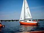
Sailboat on the Steinhuder Meer

Starting point to the Wilhelmstein island : emigrant boats at the pier in Steinhude
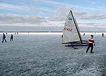
Ice sailors on the frozen lake, 2012


See also
- Ecological protection station Steinhuder Meer
- List of lakes in Germany
- List of lakes in Lower Saxony
literature
- Thomas Brandt, Dirk Herrmann, Bernhard Volmer, Thomas Beuster: Nature experience Steinhuder Meer. A travel and leisure guide. Hannover 2002, ISBN 3-7842-0624-7 .
- Thomas Brandt, Cordula Jülch, Bernhard Volmer: The Steinhuder Sea. Fascination of a landscape . Edition Temmen , Bremen 2003, ISBN 3-86108-904-1 .
- Thomas Brandt, Bernhard Volmer: The Steinhuder Sea. Images of a landscape . Edition Temmen, Bremen 2011, ISBN 978-3-8378-5018-5 .
- Holger Buschmann, Bruno Scheel, Thomas Brandt: Amphibians and reptiles in the Schaumburger Land and the Steinhuder Meer . Rangsdorf 2006, ISBN 3-9810058-2-1 .
- Klaus Fesche: Off to the Steinhuder Meer! History of tourism at the largest inland lake in Lower Saxony . (= Cultural landscape Schaumburg. 2). Publishing house for regional history, Bielefeld 1998, ISBN 3-89534-220-3 .
- Jo Lüdemann: Steinhuder Meer and the Lake Province. Green heart publishing house , Ilmenau 2006, ISBN 3-935621-42-6 .
- The Steinhuder Meer. A collection of messages and descriptions up to 1900 . With translations and follow-up comments, ed. by Curd Ochwadt. 2nd Edition. Charis-Verlag, Hanover 1975, ISBN 3-921160-03-0 .
- Steinhuder Meer Nature Park. Official hiking map of the nature park . (= Lower Saxony leisure cards. F2). 2nd Edition. Land survey + geographic base information Lower Saxony, Hannover 2000, ISBN 3-89435-619-7 .
- Peter Weißköppel: The bird world on the Steinhuder Meer and in its wider area . 2nd, completely revised edition. Wunstorf 1975, DNB 770634710 .
- Josef Merkt: On the limnology of the Steinhuder Meer. In: Courier Research Institute Senckenberg . No. 37, Frankfurt am Main 1979 (43), pp. 59-62.
- Ernst Andreas Friedrich : Natural monuments of Lower Saxony. Hanover 1980, ISBN 3-7842-0227-6 .
- Wolfgang Schulze: All about Seelze and Garbsen. Historical forays through the country between Deister and Steinhuder Meer. 2nd Edition. Ellen Harenberg-Labs, 1987, ISBN 3-89042-024-9 .
- Timm Weski: The Steinhuder Sea. An archaeological-cultural-historical consideration. In: Reports on the preservation of monuments in Lower Saxony. 3/2013, pp. 136-144.
- Verena and Volker Stahnke (text): Steinhuder Meer. In Silke Beck, Susanne Wildermann, Birgit Roos, Burkhard Wetekam (Red.): 12 green treasures. Discovery tours for children in the city and region of Hanover , for children between 5 and 12 years, publisher: Wissenschaftsladen Hanover eV in cooperation with the state capital Hanover and the Hanover region, Hanover: Transfer-Medien, 2013, ISBN 978-398-14315-5 -1 ; Table of contents and publisher's announcement ( Memento of May 5, 2015 in the Internet Archive ), pp. 60–67
Movie
- The Steinhuder Meer. Lower Saxony's natural oasis. Documentary, Germany, 2006, 45 min., Written and directed: Rolf Sziringer, Klaus Weißmann, first broadcast: July 19, 2006, film information ( memento from September 29, 2012 in the Internet Archive ) by NDR.
Web links
- Guideline for planning surface water measures of the NLKWN (pdf)
- Geological history of the Steinhuder Meer with photos and maps by the State Office for Mining, Energy and Geology in Lower Saxony, (pdf)
- Steinhuder Meer: Holidays on your doorstep at ndr.de from July 18, 2019
- Ulrich Staesche: Das Steinhuder Meer ( Memento from September 27, 2007 in the Internet Archive ) (PDF; 500 kB) in: Academy of Geosciences in Hanover, publications, issue 20 (2002), pp. 46–53.
Individual evidence
- ↑ a b c d data on Steinhuder Meer at the Federal Environment Agency. (PDF; 35 kB) Retrieved July 2, 2008 .
- ↑ Note: curve smoothed, without islands
- ↑ Measurement in https://www.umweltkarten-niedersachsen.de/GlobalNetFX_Umweltkarten/ with Layers DTK25, hierarchical area directory 1… 4 and water network
- ↑ Jan Peter Wiborg: The water level of the Steinhuder Meer is still far too low. In: Schaumburger Nachrichten , January 3, 2019
- ↑ Wasserstand Steinhuder Meer online tourism guide
- ↑ Standard data sheets / complete area data of the FFH areas in Lower Saxony. Lower Saxony Ministry for the Environment, Energy, Building and Climate Protection , November 26, 2015, accessed on April 7, 2018 .
- ↑ Standard data sheets / complete area data of the EU bird protection areas in Lower Saxony. Lower Saxony Ministry for the Environment, Energy, Building and Climate Protection , July 28, 2009, accessed on April 7, 2018 .
- ↑ sr / dpa : Steinhuder Meer: Researchers are looking for a sunken castle. In: Focus from August 4, 2009.
- ↑ Jörg Rocktäschel: Steinhuder Meer: The search for the Kranenburg continues. In: HAZ of July 29, 2009.
- ↑ Reference to steinhuder-meer.de
- ↑ Analysis of the existing natural park plan for Steinhuder Meer at hannover.de from April 2, 2015 (pdf, 4.6 MB)
- ↑ The Volkswagen floating stage on the Steinhuder Meer ( Memento of the original from March 4, 2016 in the Internet Archive ) Info: The archive link was inserted automatically and has not yet been checked. Please check the original and archive link according to the instructions and then remove this notice. . Retrieved June 30, 2015.
- ↑ Reports on the preservation of monuments 2013/3