
Neustadt am Rübenberge
| coat of arms | Germany map | |
|---|---|---|

|
Coordinates: 52 ° 30 ' N , 9 ° 28' E |
|
| Basic data | ||
| State : | Lower Saxony | |
| County : | Hanover region | |
| Height : | 38 m above sea level NHN | |
| Area : | 357.52 km 2 | |
| Residents: | 44,386 (Dec. 31, 2019) | |
| Population density : | 124 inhabitants per km 2 | |
| Postal code : | 31535 | |
| Primaries : | 05032, 05034, 05036, 05072, 05073, 05074 | |
| License plate : | H | |
| Community key : | 03 2 41 012 | |
| LOCODE : | DE NRB | |
| City structure: | 34 districts | |
City administration address : |
Nienburger Strasse 31 31535 Neustadt am Rübenberge |
|
| Website : | ||
| Mayor : | Dominic Herbst ( Greens ) | |
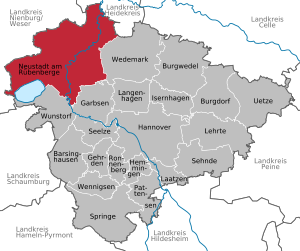
| Location of the city of Neustadt am Rübenberge in the Hanover region | ||
  |
||


Neustadt am Rübenberge is a medium-sized town and independent municipality in the Hanover region of Lower Saxony , between Bremen and Hanover . The name of the city begins with Neustadt a. Rbge. abbreviated.
geography
location
The city is located on the Leine northeast of Steinhuder Meer and Totem Moor . In a broader sense, Neustadt is in the so-called bacon belt of Hanover, but in a narrower sense Neustadt is relatively rural. The average population density is 124 inhabitants per km²; if you subtract the core city, there are about 56 inhabitants per km². With its area of 357.52 km² - this is about a thousandth of the area of Germany - Neustadt is one of the largest cities in Germany and is the largest district city in the "old federal states".
City structure
Neustadt consists of the core town (the former district town) and 33 surrounding current districts (formerly: municipalities), which are also summarized under the name "Neustädter Land":
|
|
Neustadt also includes some smaller, formerly partially independent settlements. These are Baumühle and Brunnenborstel (belong to Laderholz), Dinstorf (belongs to Brase), Himmelreich (to Empede), Mecklenhorst, Moordorf (to Poggenhagen), Scharnhorst (to Basse) and Warmeloh (to Esperke).
Chronicles of the history and current situation are available for several earlier communities (e.g. Amedorf, Basse, Bordenau, Evensen, Hagen, Helstorf, Laderholz, Mandelsloh, Mariensee, Niedernstöcken, Nöpke, Stöckendrebber, Vesbeck, Warmeloh and Wulfelade), which are of interest to regional historians Experts have been written, partly together with committed villagers.
Neighboring communities
| Heidekreis district | ||
| District of Nienburg / Weser |
.svg)
|
Wedemark |
| Wunstorf | Garbsen |
geology
Like the entire north German plain , the Ice Ages also shaped the landscapes between Aller , Weser and Wietze and thus also the urban area of Neustadt. The urban area can be divided into three parts:
- the Leineaue , which stretches from north to south and narrows in the city center from about 700 to 200 m,
- the Steinhuder Meer with the adjoining Dead Moor ,
- the Pleistocene sand upheavals like moraines that stretch west of the Leine over the whole north of the urban area.
The glaciation area of the last Ice Age no longer reached Neustadt. Therefore, the area has only been indirectly influenced by wind and (melt) water.
In the subsurface there are sea deposits from the older Cretaceous period, the so-called Wealdenformation, which can also be found above ground in a few places, as the line has cut into this formation in the course of its history and thus also caused erosion. Today, the geology of the Cretaceous period is difficult to recognize in the cityscape: the castle and parts of the city center lie on a small ridge of the Deister sandstone , which ultimately gave the beet mountain its name. Sediments from the Cretaceous material extend from the core city eastward over the industrial area east to the line Mecklenhorst - Suttorf.
Furthermore, this sandstone was also of economic importance; there were quarries on the right side of the Leine, but their stones were only used locally. The aforementioned Wealdenformation also leads to smaller coal seams, which were produced in three shafts in the 1870s, but which ultimately produced insufficient amounts of coal. From this time there is still a myth that the operator of the ironworks at the time wanted to smelt his ore with peat, but this ultimately failed.
history
prehistory
Relics from numerous epochs of human history have been found in today's urban area. Finds from gravel pits, such as in Poggenhagen, can be assigned to the Upper Palaeolithic . There are also mammoth remains , especially teeth from the time of the Leinetal- Palaeolithic .
After the Ice Age, the landscape in the Neustadt area began to change radically, from a tundra landscape to a more lush vegetation with partly dense forests. From the Mesolithic era there have been finds of living spaces, especially around the Steinhuder Meer , where people specialized in fishing.
With the settling of people in the Neustädter Land testimonies of the funnel cup culture can be found. These include destroyed large stone graves that were located on the road between Neustadt and Schneeren on the so-called Breitensteinberg .
Furthermore, burial mounds and urn fields from the Bronze Age are known. Forest forges for Neustadt are documented from this time.
Early and Middle Ages

Early traces of settlement can be seen in the Lüningsburg south of the city in the area of today's cemetery of the same name. It was the remains of an early medieval ring wall around the 10th century, which probably served as a refuge for the population .
Neustadt am Rübenberge was founded around 1200 by Count Bernhard II von Wölpe and was mentioned in a document in 1215 as "nova civitas" (translated: "new city"). In documents from later centuries, various other place names have come down to us, such as Nienstadt in front of the Rouwenberge in 1426 and Nygestadt in 1523. At that time the surrounding country belonged to the County of Wölpe , which had the Wölper Silberpfennige minted in Neustadt. In addition to the creation of the secular center of Neustadt, Count Bernhard had the Cistercian convent Mariensee built as a spiritual center in which nuns lived secluded from the world.
In 1302 the county was sold to the Guelph Duke Otto the Strict of Braunschweig and Lüneburg. The medieval castle next to the village was named in 1493 as "castrum Rouvenberg". Over the years this name was changed to "Rübenberg" when the language was changed. There is no agreement on the meaning of the original name. It is believed that the Rouvenberg was a rough, stone-covered elevation in the surrounding flat land. A connection with the beet plant is unlikely, because the economically important sugar beet was not yet introduced at the time.
16th Century


In 1505, the 35-year-old Duke Erich I von Calenberg , who was born on the medieval Neustädter Rouvenburg, made the town his second seat of government. Parts of the castle fell victim to a fire in 1563. His son, Duke Erich II the Younger, began rebuilding in 1573, when the representative Landestrost Castle was built in the Weser Renaissance style . At the same time, he made the castle defensible and had the neighboring town of Neustadt expanded into a city fortress typical of the 16th century. The castle and town were surrounded by fortifications with acute-angled bastions . To this end, earth walls were built and deep moats dug. The place and castle with an area of 10 hectares were surrounded by a wall-supported rampart of 1800 m length. The walls were 9 m high and 2.3 m thick. The entire wall was 37 to 42 m wide. The structure of the entire fortress corresponded to the requirements that the development of powder guns had brought about. Bastionnaires' fortifications in Italy and the Netherlands served as a model. Italian engineers who also worked in other locations were commissioned with the construction. The fortified castle was one of the strongest fortresses in north-west Germany due to its elaborate fortifications . With the construction, the Duke renamed the city of Neustadt "Landestrost". The residents of Neustadt, however, called it “land corruption” because of the enormous cost of the fortifications and the many people who lost their lives while the stones were being mined. Only the castle kept the name "Landestrost", because after the Duke's death in 1584 the city took on its original name again.
Neustadt and the surrounding country became Evangelical Lutheran in 1543. During the Thirty Years' War the city surrendered in 1626 after a fifteen-day siege by around 1000 men from the imperial-Catholic general Tilly . The city and fortress, which held 200 Danish musketeers , were fired at with cannons. The reason for surrender was probably not the damage, but the lack of supplies in the city and the lack of defensive artillery. Tilly quartered four companies of foot soldiers as garrison troops in Landestrost Castle, which used it as barracks for nine years. In 1635 the town was relieved of it after three months of starvation. In the third and largest city fire in 1727, 100 of the city's 108 residential buildings were destroyed, and in the two following years Neustadt was rebuilt according to its current layout.
- How abundant Georg II knew how to donate is shown, among other things, in the year 1727, when he donated 100,000 thalers from his own resources to rebuild the cremated Neustadt am Rübenberge.
19th century


In 1847, on December 12th, the first railway on the Hanover – Bremen line stopped at Neustädter Bahnhof. At the time the city had 176 residential buildings with 1507 inhabitants.
Since 1855 the city has been the seat of the Neustadt am Rübenberge district court .
In 1855 there were plans to build a glassworks between the village and the Dead Moor and to heat it with the peat obtained there . After difficulties with the companies involved, the government approved the construction of a steelworks for the production of railroad tracks in 1856 . The railway connection from Neustadt and the hope of being able to use peat as fuel were beneficial for the industrial settlement. As early as 1857, 1,100 recruited workers from Silesia and Westphalia were engaged in construction, drainage and potting work. After completion, blast furnaces , puddle furnaces , steam engines and a rolling mill with peat firing were running . However, the company was bankrupt after a short time in 1858. The reasons were the risky financing and overly optimistic calculations about possible sales at other steelworks. Peat was also not used as fuel for iron smelting and hard coal had to be bought. The citizens of Neustadt were also affected by bankruptcy, as a number of jobs were lost and investments in the town became useless. In 1869 the entrepreneur Bethel Henry Strousberg bought the smelter to produce rails for railway construction in Romania. Around 500 employees were already working there in 1869. After Strousberg's arrest in St. Petersburg in 1875, his companies went bankrupt, including the iron and steel works in Neustadt in 1878. The ironworks were finally stopped in 1888. Then a company for roofing felt and peat processing used the factory building until 1975.
In 1885 the district of Neustadt am Rübenberge was founded. It also included the County of Wölpe. Within the next 30 years the first schools and the first closed settlement were built in Neustadt.
20th century

South of today's district of Eilvese in the Dead Moor , after two years of construction, the 260 m high Funkenturm was completed in 1913 as the tallest German structure at the time. When it went into operation in June 1914, the first radio contact between Europe and the USA was established. Kaiser Wilhelm II stayed in Neustadt and Eilvese for this event . Until its demolition in 1931, the transmitter sent telegrams overseas.
During the Second World War there was a larger barrack camp for the Reich Labor Service (RAD) in Neustadt , which in 1945 served as a collection point for the training departments returned from East Prussia and Poland. From here the transfer to the Wehrmacht took place.
During the war, only the “ Lion Bridge ” built in 1687 was destroyed over the Leine . The German Wehrmacht blew it up in April 1945 when British troops were on it and were advancing on the place. 24 British soldiers were killed.
About the events in Neustadt on April 7, 1945, it was stated in the "Hannoversche Presse", district supplement Neustadt, on May 5, 1950:
- On April 7, 1945, in the afternoon, Neustadt prepared itself for the occupation of the city. [...] At 3 p.m. the British had entered Bordenau from Wunstorf Airport and at 4 p.m. some farmers came to the city who reported: “They are in Poggenhagen making tea”. […] At 6 p.m. District Administrator S., the Chief of Police, District Fire Chief C. and District Administrator F. gathered in the District Office. Kaufmann B. asked the district administrator to act as a mediator to prevent the bridge from being blown, which might cause severe suffering for the city. But District Administrator S. found himself unable to do anything against the military order. One had probably given up hope of being able to save the bridge. […] At that moment, at 11 pm, a terrible bang tore through the silence of the night and at the same time the hopes of the residents. […] The next morning some people from Neustadt dared to be on a leash. The western arch of the 250-year-old bridge lay in the water and the splash of blood betrayed the drama that had taken place here. Just as the English were in droves on the bridge, the German sergeant had set off the explosive charge behind the Schützenplatz houses.
"District fire chief C." refers to the then district fire brigade leader Karl Coldewe (1889–1953), who was appointed "district leader of the volunteer fire brigade" and honorary officer in the fire-fighting field by order of April 18, 1940 and on April 12, 1945 by the British military government was used again as district fire brigade leader.
After the war, the number of residents in the city rose sharply, as Neustadt had largely been spared the destruction of the war and many refugees and displaced persons sought refuge here.
The city wall was almost completely preserved until 1948, but had to give way due to the immense lack of space (the inside of the wall was just 1 km²). In the course of the inner city renovation, the flow of traffic in Neustadt changed in 1981. A new concrete bridge now takes the traffic load past the historic city center. After the Second World War, the Poggenhagen refugee youth camp existed in Poggenhagen .
In the 1960s Neustadt had so many residents that a high school could be built and the students no longer had to travel to the neighboring cities of Nienburg or Wunstorf ; a few years later a cooperative comprehensive school ( KGS Neustadt ) was added. Furthermore, several sports facilities (sports fields, tennis courts and the indoor swimming pool) were built. As the county seat Neustadt received its own district hospital, today the Klinikum Region Hannover belonging Klinikum Neustadt am Rübenberge .
Between 1965 and 1966, the Hibbe department store was built according to plans by the architect Karl-Heinz Lorey .
During the district reform on March 1, 1974, the district of Neustadt am Rübenberge was dissolved and merged with other districts to form the district of Hanover (excluding the city of Hanover). On November 1, 2001 this merged with the city of Hanover to form the Hanover region.
Until December 31, 2004 Neustadt am Rübenberge belonged to the Hanover administrative district , which, like all other Lower Saxony administrative districts, was dissolved on that day.
The license plate number of the former district of Neustadt am Rübenberge was NRÜ . Vehicles that were registered for road traffic before the territorial reform of 1974 still bear this registration number. These are predominantly vehicles and trailers used in agriculture and forestry.
Incorporations
In the course of the regional reform in Lower Saxony , which took place on March 1, 1974, the previously independent communities of Amedorf, Averhoy, Basse, Bevensen, Bordenau, Borstel, Brase, Büren, Dudensen, Eilvese, Empede, Esperke, Evensen, Hagen, Helstorf, Laderholz, Lutter, Luttmersen, Mandelsloh, Mardorf, Mariensee, Metel, Niedernstöcken, Nöpke, Otternhagen, Poggenhagen, Scharrel, Schneeren, Stöckendrebber, Suttorf, Vesbeck, Welze and Wulfelade are incorporated into the town of Neustadt am Rübenberge.
Population development
The graph shows the population development, which relates to the respective area, since 1821:

|
|
¹ as of December 31st
religion
_IMG_5357.jpg)

About half of the residents of Neustadt belong to the Evangelical Lutheran regional church . The parishes in Neustadt belong to the Neustadt-Wunstorf parish . There are two parishes in the city center. These include the historic Liebfrauenkirche on the market square and the Johannes Church, consecrated in 1992, on the street “Im Heidland”. Further Evangelical Lutheran parishes are located in the villages incorporated into Neustadt.
Within the political community of Neustadt there were two Roman Catholic parishes that belonged to the Diocese of Hildesheim : The town of St. Peter and Paul with branch churches in Poggenhagen and Schneeren and the parish of St. Marien Mandelsloh with the churches in Mandelsloh, Hagen and Rodewald . As part of the savings made by the diocese, the two parishes were dissolved. On November 1, 2006, the new parish of St. Peter and Paul Neustadt was established with the parish church of St. Peter and Paul built in 1965 on Bischof-Ketteler-Platz in Neustadt and the branch churches in Mandelsloh, Hagen, Poggenhagen and Schneeren. The church in Rodewald came to the parish in Nienburg and was profaned in 2015 . The parish of St. Peter and Paul, which belongs to the dean's office in Hanover, has comprised over 5,000 Catholics since the merger. In 2009 the kindergarten on Wunstorfer Straße was expanded to become a family center and the churches in Mandelsloh and Scheeren were profaned. The church in Mandelsloh is now privately owned, the church in Schneeren was demolished.
The Evangelical Free Church Congregation Neustadt ( Baptists ) belongs to the Federation of Evangelical Free Church Congregations . The community goes back to 1961. In 1971 she acquired a building on Nienburger Strasse and subsequently converted it into a community hall. In 1991 the community opened a day-care center next to the community center.
There is a New Apostolic Church on the street “Kleiner Tösel”.
The "Christengemeinde-Neustadt e. V. "belongs to the community association" Gemeinde der Christisten ecclesia e. V. “and to the union of free church Pentecostal congregations. It is located on Nienburger Strasse.
The Seventh-day Adventist Church is located on Windmühlenstrasse.
politics
City council
The city council of Neustadt am Rübenberge currently consists of 40 members. This is the specified number for a municipality with a population between 40,001 and 50,000. The council is elected for a five-year term in local elections. The current term of office began on November 1, 2016 and ends on October 31, 2021.
The mayor is also entitled to vote and sit on the council.
Council chairman is Wilhelm Wesemann (CDU).
| choice | SPD | CDU | Green | FDP | UWG | Citizens Forum | left | AfD * | total |
|---|---|---|---|---|---|---|---|---|---|
| 2016 | 12 | 13 | 5 | 2 | 4th | - | 1 | 4th | 41 |
| 2011 | 15th | 13 | 8th | 1 | 2 | 1 | 1 | - | 41 |
| 2006 | 13 | 14th | 4th | 2 | 1 | 3 | - | - | 37 |
* The AfD parliamentary group renamed itself to the Free Neustädter parliamentary group (FFN) in May 2018.
Mayor and City Manager
Dominic Herbst has been (Green) Mayor since November 1, 2019 . He prevailed against Christina Schlicker in a runoff election on June 16, 2019. Before that, the mayor Uwe Sternbeck (also Greens) was in office for 15 years. In 2004 the council parties SPD, FDP and CDU voted out city director Dieter Häseler. At that time, Sternbeck prevailed in a runoff election. On September 11, 2011, Sternbeck was re-elected in the mayoral election. His re-election was supported by the Greens and the SPD. The current deputies of the mayor are Ute Lamla (Greens), Christine Nothbaum (CDU) and Willi Ostermann (UWG).
Youth Council
The city of Neustadt has a youth council made up of 13 young people. All 12 to 18 year olds who live in the Neustadt am Rübenberge urban area have the right to vote and to vote. The youth council elections take place every two and a half years. The youth council elects a youth mayor and his deputy from among its ranks. The incumbent mayor Dominic Herbst had already been elected youth mayor in 2006.
coat of arms
The design of the municipal coat of arms of Neustadt am Rübenberge comes from the local artist and trade teacher Fritz R. Sackewitz .
- It could not be determined whether the city of Neustadt am Rübenberge has been given permission for this coat of arms, which is based on ancient traditions. The coat of arms was redesigned in 1954. This redesign did not require approval.
- The city of Neustadt am Rübenberge, newly formed by law on March 1, 1974, adopted the coat of arms of the previous city of Neustadt am Rübenberge, which was approved by the Hanover district on May 7, 1976.
|
|
Blazon : "In silver a red battlemented wall with an open gate and blue portcullis, raised by two blue-roofed pointed towers , in between on the wall an upright, red-armored , blue lion ." |
| Justification of the coat of arms: The current coat of arms of the city takes up the tradition of the older Neustädter city seals. The oldest known Neustadt seal from April 17, 1308 ( Loccum monastery archive no. 677) shows the city wall with two towers. The city wall, which used to form a border between urban freedom and rural bondage, between agriculture and the specialized division of labor, is to be seen as the hallmark of the medieval city and can thus represent a symbol of the city's history and tradition. With the transition of the city from the possession of the Counts of Wölpe to the rule of Duke Otto des Strengen of Lüneburg in 1302/1303, the Lüneburg blue lion was probably placed on the battlements of the city's coat of arms instead of the older city lord symbol of the Wölper buffalo horns . The town seal from 1308 also shows between the towers of the town wall the enthroned St. Mary with child , the patroness of the oldest town church, the Church of Our Lady (Sankt Peter). Presumably as a result of the Reformation, the figure of the Mother of God was dispensed with; The figure of the upright lion was placed on the now free space. A seal of the city from 1547 (Main State Archives Hanover Cal. Or. 100 Kleinere Calenberg. Cities No. 43) shows the lion in its current position. |
flag
|
|
Flag description: The colors blue / white, arranged one above the other, serve as the flag background. In the middle of the flag is the coat of arms of the town. Reasons for the flag: The white stands for the color of silver, which was featured in the coat of arms of the city of Neustadt a. Rbge. appears. Blue is supposed to remind of the coloring of the blue Lüneburg lion in the coat of arms. |


Town twinning
Neustadt is twinned with La Ferté Macé in France . In addition, the city is a member of the international " Neustadt in Europa working group " with 37 members from seven Central European countries (Germany, Austria, Hungary, Poland, the Czech Republic, Slovakia and the Netherlands; status 2014).
Culture and sights
Buildings in Neustadt
- The Ev.-luth. Liebfrauenkirche was built in the 13th century as a Romanesque basilica and renovated by Erich I in 1502. Since then, the nave has been a Gothic brick building . In 1828 the partially destroyed tower was built as it still exists today. However, it was extensively renovated between 2004 and 2006.
- Landestrost Castle with fortifications and south bastion as well as arcade made of hornbeam
- Bastion Erichsberg as the remainder of the city fortress
- Wallburg Lüningsburg at the municipal cemetery Lüningsburg

- Town hall, Marktstrasse 4. The half-timbered building with a hipped roof, built over a high sandstone base, was rebuilt in 1728/29 after a city fire. In 1830 it was redesigned in classicist forms. On the plastered front, a double flight of stairs leads to the main portal.
- The guard house , located directly opposite the town hall, was built in the 19th century as the night watchman's residence. It also served as a syringe house.
- Residential buildings. The image of the inner city was originally shaped by half-timbered hall houses with gable ends , of which only a few examples have survived after several city fires and since the demolitions in the post-war period. Mittelstrasse 29 is particularly attractive . The small half-timbered hall house dates from the first half of the 18th century. The hall gate was only restored a few years ago. Windmühlenstrasse 19 and 20 are among the last remaining residential buildings that were spared the great city fire of 1727 . They were probably made in 1672. Further half-timbered buildings can be found in the vicinity of the Liebfrauenkirche. At Liebfrauenkirche 2 , a two-storey house with a half-hipped roof , was built in all probability after 1728. The classicistic portal, however, only comes from a renovation carried out between 1831 and 1833. The very simple half-timbered houses No. 4 and 6 were built a little later . No. 8 , which serves as a boys' school , was built around 1703 to 1707. The drivable hallway is still present in the front part. A pair of storks has been breeding on the chimney of the building for many years. The building on the left side of Wallstraße with simple half-timbered buildings did not take place until after 1851. On Hannoversche Straße (No. 1) there is a single-storey eaves structure with eleven axes, which was built around 1815. The Richterhaus (Schloßstraße 2) was built around 1830 as a two-story, classical plastered building. It is closed by a hipped roof and has rustication on the ground floor . The neighboring house at Schloßstraße 3 is originally a half-timbered hallway house built around 1800, to which a Gothic brick facade was presented towards the end of the 19th century, so that it now gives the impression of a solid construction.
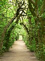 Hornbeam arbor at the castle
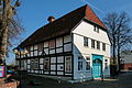 Boys' school from 1707
 Ecksteinmühle
 Former Royal district court with criminal prison


Buildings in the districts

- St. Osdag (Mandelsloh)
- Farriers Helstorf
- Dudensen post mill
- Watermill Laderholz
- Tenth barn Amedorf
- Mariensee Monastery
- Johanneskapelle Metel
- Evensen Manor
Parks
There is a park in the village on the fortress plateau of Schloss Landestrost . The nearby Steinhuder Meer nature reserve is well known .
Natural monuments
The Blankes Flat nature reserve with a moor lake is well known.
Economy and Infrastructure
economy
The purchasing power (sum of disposable income) is 18,576 € per inhabitant (2006) and the purchasing power index is currently 119.5 is (compared to the national average of 100). The unemployment rate is 6.3% (as of March 2012).
traffic

Neustadt is located on the B 6 federal highway . The B 442 begins in the village and leads south to Coppenbrügge .
The station Neustadt am Rübenberge ( Bahnhof Category 4) is located on the railway Bremen and Hannover . It is served hourly in local passenger traffic alternating from RE 1 Norddeich Mole– Emden - Bremen Hbf –Neustadt am Rübenberge– Hanover Hbf and the RE8 Bremerhaven -Lehe – Bremen Hbf – Neustadt am Rübenberge – Hannover Hbf. The S-Bahn Hanover continues with the S 2 Nienburg (Weser) - Neustadt am Rübenberge - Hanover Hbf - Haste every hour in Neustadt. The train stations Hagen (Han), Eilvese and Poggenhagen are only served by the S 2. The internal development, the connection of the districts with each other and with some neighboring towns take over bus routes of the Regiobus Hannover . Neustadt is part of the tariff association of Greater Hanover .
Personalities
sons and daughters of the town
- Erich I (1470–1540), Duke of Braunschweig-Lüneburg and ruling Prince of Calenberg-Göttingen
- Friedrich Dedekind (around 1525–1598), theologian and writer
- Euricius Dedekind (1554–1619), composer
- Henning Dedekind (1562–1626), composer
- Theodor Berckelmann (1576–1645), Lutheran theologian and Latin poet
- Johann Wissel (1584–1656), legal scholar and politician
- Heinrich Wideburg (1587–1648), Lutheran theologian and mathematician
- Ludwig Christoph Heinrich Hölty (1748–1776), poet near the Hainbund , born in the Mariensee district
- Gerhard von Scharnhorst (1755–1813), Prussian general, born in the Bordenau district
- Johann ("Iwan") von Stietencron (1811–1873), Princely Lippischer Chamberlain , politician in the Principality of Lippe
- Ludwig Enneccerus (1843–1928), co-initiator of the German Civil Code ( BGB )
- Karl FH Stadtländer (1844–1916), lawyer and politician ( NLP ) and active as senator and mayor in Bremen
- Maximilian von Engelbrechten (1851–1911), Prussian officer, most recently lieutenant general
- George von Engelbrechten (1855-1935), Prussian infantry general
- Hildegard von Rheden (1895–1987), politician ( DRP ), member of the Lower Saxony state parliament
- Karl Grabenhorst (1896–1983), architect and Prussian building officer
- Georg Grabenhorst (1899–1997), writer
- Friedrich Meyer (1910–1975), politician (SPD), district administrator of the Neustadt district and member of the Lower Saxony state parliament, born in the Mardorf district
- Wilhelm Rahlfs (1938-2014), politician (FDP)
- Sabine Postel (* 1954), actress , radio play and voice actress
- Dieter Bartels (* 1955), clown and acting teacher
- Friedrich Temps (* 1955), chemist and university professor
- Detlef Selhausen (* 1955), lawyer and ministerial official
- Cord Dreyer (* 1962), journalist
- Jens Rehländer (* 1962), journalist and author
- Andreas Höhn (* 1965), record and CD producer, owner of Höhnie Records , co-founder of the punk bands Rasta Knast , Pissed Spitzels, Psychisch unabil and others
- Susanne Grote (* 1969), politician (SPD)
- Tanja Weiß (* 1969), author and lecturer
- Sven Ambrosy (* 1970), politician (SPD), district administrator in the district of Friesland
- Jan Katzschke (* 1972), musician, harpsichordist, organist and conductor
- Melanie Brinkmann (* 1974), virologist
- Mustafa Erkan (* 1984), politician (SPD)
- Philipp Winkler (* 1986), writer
- Deniz Ayçiçek (* 1990), football player
- Malte Semisch (* 1992), handball player
- Sebastian Ernst (* 1995), soccer player
- Fynn Arkenberg (* 1996), football player
People related to Neustadt
- Georg Friedrich Ballhorn (1770–1805), doctor, court medic and vaccination pioneer of protective vaccination (vaccination) in Germany
- Fritz Hartmann (1896–1974), politician (SPD), Member of the Appointed Braunschweig Landtag and Lord Mayor of Salzgitter
- Joachim Haupt (1900–1989), politician (NSDAP)
- Joachim Hackbarth (1906–1977), plant breeder and geneticist
- Friedel Jenny Konitzer (1915–2013), painter and graphic artist
- Michael Baldauf (1918–1997), politician (CDU)
- Hans Derben (1927–2009), politician (CDU)
- Ingrid M. Pawlowski (1940–2010), artist for painting, graphics and sculpture
- Peter Marggraf (* 1947), sculptor, draftsman and book maker
- Uwe Sternbeck (* 1961), politician (Greens), he was mayor of this city from 2004 to 2019
- Robert Enke (1977–2009), football player
- Wiebke Osigus (* 1981), politician (SPD)
- Dominic Herbst (* 1987), politician (Greens), he has been mayor of this city since November 2019
literature
- Wilhelm Winkel: History of the city of Neustadt a. Rbge . Ed .: District group Neustadt of the Heimatbund Lower Saxony and the city of Neustadt a. Rbge. 1966.
- Hubert Brieden: Jews in Neustadt a / Rbge. Discrimination, persecution and extermination of a minority . Hanover 1992.
- Hans-Cord Sarnighausen: Local lawyers from 1683 to 1866 in Neustadt am Rübenberge . In: Genealogy, German journal for family history . No. 4 . Degener Verlag, Insingen 2013, p. 715-745 .
Web links
- Website of the city of Neustadt am Rübenberge
- Extensive collection on the history of the city of Neustadt am Rübenberge
- Rübenberger photos on Instagram
Individual evidence
- ↑ State Office for Statistics Lower Saxony, LSN-Online regional database, Table 12411: Update of the population, as of December 31, 2019 ( help ).
- ↑ Our localities introduce themselves. In: Website of the city of Neustadt am Rübenberge. 2018, accessed June 22, 2020 .
- ↑ residents per location according to the population register. (PDF; 86 kB) In: Website City Neustadt am Rübenberge. March 31, 2020, accessed June 22, 2020 .
- ↑ a b Dietrich Bohnsack: Landscape and prehistory . In: Wilhelm Winkel: History of the City of Neustadt a. Rbge . 1966, p. 15-20 .
- ↑ Hans Pupke: companies and business enterprises . In: Wilhelm Winkel: History of the City of Neustadt a. Rbge . 1966, p. 369 .
- ↑ Hans Ehlich: farmers citizens burning villages . In: Calenberger Blätter . No. 4 . Theo Oppermann Verlag, Wunstorf, S. 130 .
- ↑ A plan from the 18th century, which shows the state before the great fire of 1727, notes a "garden garden" north of the fortifications, about which nothing is known.
- ↑ Nancy Kratochwill-Gertich, Antje C. Naujoks: Neustadt am Rübenberge . In: Herbert Obenaus in collaboration with David Bankier and Daniel Fraenkel (eds.): Historical manual of the Jewish communities in Lower Saxony and Bremen . Wallstein Verlag, Göttingen 2005, ISBN 3-89244-753-5 , p. 1092 ( digitized version [accessed on October 6, 2019] excerpt from the so-called fire plan of 1727).
- ^ Wilhelm Havemann: History of the Lands Braunschweig and Lüneburg . tape 3 . Göttingen 1857, p. 642 .
- ↑ a b Friedrich W. Harseim, C. Schlüter (Ed.): Statistical manual for the Kingdom of Hanover . Schlueter Verlag, 1848, p. 55 ( digitized version in Google Book Search [accessed April 28, 2020]).
- ^ Matthias Blazek: Department leader Karl Coldewe from Celle . In: Fire Brigade Journal . 10th year September 2010, p. 32 ff .
- ^ Friedrich Lindau : Hanover. Reconstruction and destruction. The city in dealing with its architectural identity . 2nd Edition. Schlütersche Verlagsgesellschaft, Hanover 2001, ISBN 3-87706-607-0 , p. 331 ( digitized version in Google Book Search [accessed April 28, 2020]).
- ^ Matthias Blazek: From the Landdrostey to the district government - The history of the district government of Hanover as reflected in the administrative reforms . Ibidem-Verlag, Stuttgart 2004, ISBN 3-89821-357-9 .
- ↑ a b Federal Statistical Office (ed.): Historical municipality register for the Federal Republic of Germany. Name, border and key number changes in municipalities, counties and administrative districts from May 27, 1970 to December 31, 1982 . W. Kohlhammer, Stuttgart / Mainz 1983, ISBN 3-17-003263-1 , p. 198 .
- ^ Gustav Neumann (Ed.): The German Empire in geographical, statistical and topographical relationship . 2nd Edition. tape 2 . Grg. Ferd. Otto Müller's Verlag, Berlin 1875, p. 462 ( digitized in Google Book Search [accessed April 28, 2020]).
- ^ Hermann Guthe : The Lands of Braunschweig and Hanover . Klindworth's Verlag, Hannover 1867, p. 663 , Appendix p. 2 ( digitized version in Google Book Search [accessed April 28, 2020]).
- ^ Michael Rademacher: German administrative history from the unification of the empire in 1871 to reunification in 1990. District Neustadt am Rübenberge. (See under: No. 39; online material for the dissertation, Osnabrück 2006).
- ↑ Statistisches Bundesamt Wiesbaden (Ed.): Official municipality register for the Federal Republic of Germany - 1957 edition (population and territorial status September 25, 1956, for Saarland December 31, 1956) . W. Kohlhammer, Stuttgart 1958, p. 160 ( digitized version ).
- ↑ Lower Saxony State Administration Office (ed.): Municipal directory for Lower Saxony . Municipalities and municipality-free areas. Self-published, Hanover January 1, 1973, p. 24 , district of Neustadt am Rübenberge ( digitized [PDF; 21.3 MB ; accessed on June 21, 2020]).
- ^ Municipalities in Germany by area and population. (XLSX; 895 kB) In: Destatis website. Federal Statistical Office, December 31, 1975, accessed on October 6, 2019 (see: Lower Saxony, No. 1296).
- ^ Community directory - archive - regional structure - annual editions - Lower Saxony. (All politically independent municipalities in EXCEL format). In: Destatis website. Federal Statistical Office, accessed on November 4, 2019 .
- ^ The election results of the local elections 2016. In: Website Neustadt a. Rbge. Retrieved October 2, 2017 .
- ↑ a b City Council. In: Website Neustadt a. Rbge. Retrieved October 2, 2017 .
- ^ Lower Saxony Municipal Constitutional Law (NKomVG); Section 46 - Number of Deputies. In: Lower Saxony Regulations Information System (NI-VORIS). December 17, 2010, accessed October 6, 2019 .
- ↑ Kathrin Götze: Neustadt's council group leaves the AfD closed. In: Hannoversche Allgemeine Zeitung . June 9, 2018, accessed June 21, 2020 .
- ↑ Dominic Herbst becomes Neustadt's new mayor. In: Website Neustadt a. Rbge. Retrieved November 17, 2019 .
- ↑ Dominic Herbst. In: Kommunalwiki.boell.de. Retrieved November 4, 2019 .
- ↑ Designs of coats of arms by Fritz R. Sackewitz. In: Wikimedia Commons. Retrieved September 30, 2017.
- ↑ a b c Hanover district (ed.): Wappenbuch Landkreis Hannover . Self-published, Hanover 1985, p. 270-271 .
- ↑ Liebfrauenkirche Neustadt a. Rbge. In: Website Liebfrauen & Johannes - Evangelical Lutheran Church in Neustadt. Retrieved October 2, 2017 .
Barsinghausen | Burgdorf | Burgwedel | Garbsen | Gehrden | Hanover | Hemmingen | Isernhagen | Laatzen | Langenhagen | Taught | Neustadt am Rübenberge | Pattensen | Ronnenberg | Seelze | Sighted | Jump | Uetze | Wedemark | Wennigsen (Deister) | Wunstorf
Bevensen (with Büren and loader wood ) |
Bordenau |
Eilvese |
Helstorf (with Esperke / Warmeloh , Luttmersen and Vesbeck ) |
Mandelsloh (with Amedorf , Brase / Dinstorf , Evensen , Lutter , Niedernstöcken , Stöckendrebber and Welze ) |
Mardorf |
Mariensee (with Empede / Himmelreich and Wulfelade ) |
Mühlenfelder Land (with Borstel , Dudensen , Hagen and Nöpke ) |
Neustadt |
Otternhagen (with Averhoy , Basse , Metel and Scharrel ) |
Poggenhagen |
Snow |
Suttorf