
Coppenbrugge
| coat of arms | Germany map | |
|---|---|---|

|
Coordinates: 52 ° 7 ' N , 9 ° 33' E |
|
| Basic data | ||
| State : | Lower Saxony | |
| County : | Hameln-Pyrmont | |
| Height : | 142 m above sea level NHN | |
| Area : | 89.81 km 2 | |
| Residents: | 7040 (Dec. 31, 2019) | |
| Population density : | 78 inhabitants per km 2 | |
| Postal code : | 31863 | |
| Primaries : | 05156, 05159 | |
| License plate : | HM | |
| Community key : | 03 2 52 004 | |
| LOCODE : | DE CPP | |
| Spot breakdown: | 12 districts | |
| Address of the stain management: |
Schloßstraße 2 and 14 31863 Coppenbrügge |
|
| Website : | ||
| Mayor : | Hans Ulrich Peschka ( CDU ) | |
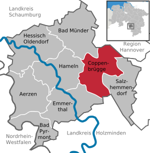
| Location of the Coppenbrügge area in the Hameln-Pyrmont district | ||
  |
||


Coppenbrügge is a stain in Lower Saxony Hamelin-Pyrmont district .
geography
location
The place is on the northern edge of the Ith , about 15 kilometers east of Hameln .
Spot breakdown
The area consists of the following districts:
- Bäntorf
- Behrensen
- Bessingen
- Bisperode
- Brünnighausen
- Coppenbrugge
- Diedersen
- Dörpe
- Harderode
- Herkensen
- Scorn
- Marienau
Neighboring communities
| Bad Münder |
Jump Region Hannover |
|
| Hamelin |
.svg)
|
|
| Emmerthal |
Halle district of Holzminden |
Salzhemmendorf |
history
Coppenbrügge was first mentioned in a document around 1000 in a border description of the Diocese of Hildesheim as Cobbanbrug . On March 9, 1062 gave the Emperor Henry IV. The Bishop of Hildesheim Hezilo forestry spell in Coppenbrügge. Around 1200, Count Bernhard von Poppenburg, who sat at Poppenburg Castle , built the Spiegelburg near Lauenstein . After that he called himself Bernhard von Poppenburg and Spiegelberg. The Spiegelburg was built in the valley between Ith and Osterwald on the old military and trade route near a swamp area. The road was Hellweg , which led from Aachen to Königsberg . Then it was Reichsstraße 1 and today Bundesstraße 1. From 1217 Count Bernhard called himself only "von Spiegelberg".
In 1226 a feud broke out between Bernhard von Spiegelberg and Bodo von Homburg . In 1238 the Homburgs captured Spiegelberg Castle, the Counts of Spiegelberg left the country. In 1247 the Homburgers build Lauenstein Castle. In 1260 Johann von Brünnighausen gave his property to the Bishop of Minden . This property was handed over to the Count von Spiegelberg in 1281, which resulted in the Grafschaft Spiegelberg with the capital Coppenbrügge. Around 1300 the Spiegelbergers donated the Carmelites to build their monastery in Marienau and in 1303 the Coppenbrügge Castle was rebuilt.
From 1409 to 1435 the Spiegelbergers fought with the Guelph dukes for new areas on the Weser and in the Hamel Valley . The fighting ended in a complete defeat for the Spiegelbergers, but the county remains. In 1494 the Spiegelberger inherited the county of Pyrmont .
1519 broke the Hildesheimer pin feud from the Bishopric of Hildesheim came with the Guelph principalities Brunswick-Wolfenbüttel and Calenberg in conflict. This originally purely local feud developed into a dispute between Lower Saxony territorial princes, in which the Counts of Spiegelberg were also involved. The feud did not end until 1523.
Coppenbrügge was reformed around 1540 . A little later, in 1557, Count Philipp von Spiegelberg and Pyrmont fell in the battle of Saint-Quentin . The rule initially passed to the Lippe family from 1557 to 1584 . From 1584 the house Gleichen-Tonnaund ruled , from 1631 the house Nassau-Dietz . It was followed by the House of Nassau-Orange ( Netherlands ) at the beginning of the 18th century .
In 1692 almost all town houses were destroyed in a major fire. On August 10, 1697, the Russian Tsar Peter the Great visited Coppenbrügge, together with the Electress Sophie of Hanover and the Electress Sophie Charlotte of Brandenburg . On September 18, 1740, Friedrich II of Prussia also came . In 1764 the old sulfur spring in the Coppenbrügger Landwehr was renewed and expanded for healing purposes.
Spiegelberg came to the Kingdom of Westphalia in 1810 , and through the Congress of Vienna (1815) the county returned to the Nassau-Orange (Netherlands). But as early as 1819 Spiegelberg was sold to the Kingdom of Hanover as the "Coppenbrügge Office" ; in 1866 it became Prussian.
The Hameln – Hildesheim railway line was built in 1875, and a few years later (1906) Carl Netter founded the Lindenbrunn sanatorium . The Feuerhake Fountain was built in 1908. It was a thank you from the municipality of Coppenbrügge to Ernst Feuerhake (1850-1924), who donated a water pipe to the municipality. He also donated the two large colored windows in the choir of St. Nicolai Church. Coppenbrügge has been part of the state of Lower Saxony since 1945.
In 1957 the outdoor pool was inaugurated. In 1958 the fundamental renovation of the church was completed. In 1962 the domain land was dissolved and the buildings were sold and demolished. The manor house became the state forest office. In 1969 the Lindenbrunn sanatorium was given up by its owners and sold to the Association for the Care of Severely Handicapped People. In 1972/1973 the newly established Lindenbrunn specialist hospital with a capacity of 255 beds was inaugurated. The indoor pool was opened in 1976. After thorough renovation of the castle ruins and the former district court building, the museum in the castle was opened in 1986. In 1993 the last districts were connected to the central water supply and the central sewage disposal system.
In 2011/2012 the swimming pool was completely renovated. The swimming pools are now heated with district heating from a biogas plant in Brünnighausen. The indoor swimming pool was also rebuilt and the entire roof area was equipped with solar collectors.
In the school year 2015/16 in the premises of the former opened Förderschule Free School Weserbergland its doors, a private school in independent agencies , after the Montessori working approach.
Origin of the place name
The old names of Coppenbrugge in the 10th century are Cobbanbrug, 1013 Cobbanberg, 1062 Choppenbrukke, 1281 Cobbenbrukke, 1381 Kobbenbrughe, 1388 Kopenbrugge and 1393 Cobbenbrugge. The document from 1013 is the only one that contains “-berg” and is probably an incorrect spelling or a wrongly heard form. The first part probably belongs to an old Germanic name for “mountain, mountain peak”, ancient Germanic “kuban-, koban-”, Middle High German “kuppe”, so “top, summit”, early New High German “koppe”, ie “mountain top, tree top”. “Head” also means “the top of a mountain”, in the end, of course, this also includes the summit, including the Schneekoppe. In the second part of the Low German word is “bruges”, meaning “bridge”. Coppenbrügge therefore means "mountain bridge, bridge on the mountain". Given the location on the northern tip of the Ith , this is a conclusive interpretation.
Incorporations
As part of the regional reform in Lower Saxony , the previously independent municipalities of Bäntorf, Behrensen, Bessingen, Bisperode, Brünnighausen, Diedersen, Dörpe, Harderode, Herkensen, Hohnsen and Marienau were incorporated into the municipality of Coppenbrügge on January 1, 1973.
Population development
|
|
¹ on June 6th, with the districts incorporated in 1973
² on May 27th, with the districts incorporated in 1973
³ on December 31st

|
religion

The Protestant inhabitants belong to the Evangelical Lutheran parishes Coppenbrügge , Bessingen-Ith Nesselberg and at Ith with their own parishes. They are part of the church district Hildesheim Country Alfeld.
The Catholic Church of Mary Queen of the Apostles , built in 1968, was profaned in 2012 . Today, St. Benedikt in Lauenstein, 5 km away, is the closest Catholic church.
politics
Municipal council
The Council of the Fleckens Coppenbrügge consists of 20 councilors and councilors. This is the specified number for a municipality with a population between 7001 and 8000 inhabitants. The 20 council members are elected by local elections for five years each.
The full-time mayor is also entitled to vote and sit on the council.
The last local election on September 11, 2016 resulted in the following:
- CDU : 8 seats
- SPD : 6 seats
- Alliance 90 / The Greens : 1 seat
- FDP : 2 seats
- Free voters : 1 seat
- AfD : 2 seats
mayor
The full-time mayor of the Coppenbrügge area is Hans-Ulrich Peschka (CDU). In the last mayoral election on May 26, 2019, he was re-elected as incumbent with 76.1% of the vote. The turnout was 68.2%. Peschka will begin his third term on November 1, 2019. His deputies are Karin Dröge (CDU) and Taina Paulmann (FDP).
Coppenbrügge local council
The local council of the village of Coppenbrügge consists of five councilors and four councilors. He represents the Coppenbrügge districts of Coppenbrügge, Dörpe and Marienau at the municipal level.
(Status: local election September 11, 2016)
Local mayor
The local mayor is Cord Bormann (SPD). His deputy is Ingo Mücke (UWG-FC).
Further local councils and mayors of the patch
→ See: Bisperode - Politics
→ See: Brünnighausen - Politics
coat of arms
|
|
Blazon : "A golden deer antler floatingin green over an open golden barrel ." |
| Foundation of the coat of arms: The coat of arms was probably created at the time when the Counts of Gleichen granted the town city privileges in 1618 . In a seal from the 17th century, a barrel can be seen in the base of the shield and antlers on the upper edge of the shield. It comes from the Counts of Spiegelberg , who also had a stag in their shield and crest . The barrel goes back to the old brewing system, but it can also be a misinterpretation of the pot helmet of those at Spiegelberg. |
flag
The municipality flag is green and decorated with yellow borders, the coat of arms is placed in the middle.
Culture and sights
Buildings
- Coppenbrügge Castle
- St. Nicolaikirche
- Fire Hook Fountain
- Voldagsen manor
Museums
- Museum in the Coppenbrügge Castle
Economy and Infrastructure
traffic
The place is on the federal highways 1 and 442 and on the Elze – Löhne railway line . The railway line is currently operated by the NordWestBahn and runs as the Weserbahn between Bünde and Hildesheim . The trains run every hour in the direction of Hameln and Hildesheim. There are various bus connections.
Construction of the Coppenbrügge / Marienau bypass in the course of Bundesstrasse 1 began on January 7, 2016. Complete completion is planned for the end of 2022. Individual sections of the route should be released earlier.
Infrastructure
In Coppenbrügge there is a heated swimming pool, an indoor swimming pool, various discount grocery stores, a petrol station, several doctors, a hospital, retailers, craft businesses and restaurants. A primary school and two day-care centers, a forest kindergarten as well as old people's and nursing homes are available.
tourism
In the tourist area there are various offers such as a leisure area in a former gravel pit for mountain biking and shooting sports. There is a campsite and overnight accommodation through hotels and private guest houses. In the historic center of the main town there is a castle ruin, a historic fountain and a church in Romanesque style. There are hiking opportunities in the Ith .
Personalities
Sons and Daughters of the Spot
- August Seidensticker (1820–1899), forest scientist
- Eduard Bergmann (1897–1973), businessman, association official and honorary consul of Denmark
- Hans Dobbertin (1952–2006), cryptologist, born in the Coppenbrügger district of Herkensen
People connected to the stain
- Theodor Becker (1880–1952), actor, died in Coppenbrügge
literature
- Bernhard Gelderblom : The Jews of Coppenbrügge , Holzminden: Verlag Jörg Mitzkat, 2016, ISBN 978-3-95954-017-9 and ISBN 3-95954-017-5 ; contents
Web links
- Official website of the Flecken Coppenbrügge
- Collection of old picture documents from Coppenbrügge
- Website of the district of Bessingen
Individual evidence
- ↑ State Office for Statistics Lower Saxony, LSN-Online regional database, Table 12411: Update of the population, as of December 31, 2019 ( help ).
- ^ History of the Coppenbrügge area. In: coppenbruegge.de. Retrieved March 2, 2009 .
- ^ Jürgen Udolph (research): The "place name researcher". In: Website NDR 1 Lower Saxony . Archived from the original on December 2, 2016 ; accessed on August 3, 2019 .
- ↑ a b c Federal Statistical Office (ed.): Historical municipality directory for the Federal Republic of Germany. Name, border and key number changes in municipalities, counties and administrative districts from May 27, 1970 to December 31, 1982 . W. Kohlhammer, Stuttgart / Mainz 1983, ISBN 3-17-003263-1 , p. 195 .
- ^ Ulrich Schubert: Community directory Germany 1900 - district Hameln. Information from December 1, 1910. In: gemeindeververzeichnis.de. February 3, 2019, accessed on April 6, 2019 ( see under: Koppenbrügge ).
- ^ A b c Michael Rademacher: German administrative history from the unification of the empire in 1871 to the reunification in 1990. Hameln-Pyrmont district ( see under: No. 15 ). (Online material for the dissertation, Osnabrück 2006).
- ↑ a b Statistisches Bundesamt Wiesbaden (ed.): Official municipality register for the Federal Republic of Germany - 1957 edition (population and territorial status September 25, 1956, for Saarland December 31, 1956) . W. Kohlhammer, Stuttgart 1958, p. 158 ( digitized version ).
- ↑ Lower Saxony State Administration Office (ed.): Municipal directory for Lower Saxony . Municipalities and municipality-free areas. Self-published, Hanover January 1, 1973, p. 23 , Hameln-Pyrmont district ( digitized version ( memento from August 7, 2019 in the Internet Archive ) [PDF; 21.3 MB ; accessed on July 2, 2020]).
- ↑ a b c d e f g h i j community directory - archive - regional structure - annual editions - Lower Saxony. (All politically independent municipalities in EXCEL format). In: Destatis website. Federal Statistical Office, accessed on November 12, 2019 .
- ↑ Overall results of the 2016 municipal council elections. In: coppenbrügge.de. September 11, 2016, accessed October 25, 2018 .
- ^ Lower Saxony Municipal Constitutional Law (NKomVG); Section 46 - Number of Deputies. In: Lower Saxony Regulations Information System (NI-VORIS). December 17, 2010, accessed November 12, 2019 .
- ^ Election of the mayor of Flecken Coppenbrügge. In: votemanager.kdo.de. Retrieved November 12, 2019 .
- ↑ Mayor. In: coppenbruegge.ratsinformationsdienst.de. Retrieved November 11, 2019 .
- ^ Local councilor Coppenbrügge. In: coppenbruegge.ratsinformationsdienst.de. Retrieved November 12, 2019 .
- ↑ local mayor. In: coppenbruegge.ratsinformationsdienst.de. Retrieved November 12, 2019 .
- ↑ Klemens Stadler: German coat of arms Federal Republic of Germany . The municipal coats of arms of the federal states of Lower Saxony and Schleswig-Holstein. tape 5 . Angelsachsen-Verlag, Bremen 1970, p. 32 .
- ↑ Coppenbrügge / Marienau bypass in the course of Bundesstrasse 1. In: strassenbau.niedersachsen.de. Nds. State Authority for Road Construction and Transport, accessed on November 12, 2019 .
- ↑ Start of construction for two important bypasses in southern Lower Saxony. In: mw.niedersachsen.de. Nds. Ministry of Economy, Labor, Transport and Digitization, accessed November 12, 2019 .
Bäntorf | Behrensen | Bessingen | Until period | Brünnighausen | Coppenbrugge | Diedersen | Dörpe | Harderode | Herkensen | Hohnsen | Marienau