
Ith
| Ith | |
|---|---|
 Overview map: Ith and Hils in the center of the picture |
|
| Highest peak | Lauensteiner Kopf ( 439 m above sea level ) |
| location | Lower Saxony , Germany |
| part of | Weser-Leine-Berglands , Lower Saxony highlands |
| Coordinates | 52 ° 3 ' N , 9 ° 34' E |
| rock | limestone |
| Age of the rock | Upper Jurassic |
| particularities | Longest range of cliffs in Northern Germany |

The Ith [ iːt ] is up to 439 m above sea level. NHN high low mountain range in the districts of Hameln-Pyrmont and Holzminden in Lower Saxony , Germany . It is located around 40 km southwest of Hanover and, at around 22 km in length, is the longest range of cliffs in northern Germany .
geography
location
The Ith joins the Hils in the Weser-Leine-Bergland to the north-west and extends in a north-west-south-east direction in the quadrangle of the sometimes somewhat distant cities and communities of Coppenbrügge in the north, Salzhemmendorf in the east, Eschershausen in the south and Bodenwerder in the west. It lies between Coppenbrügge and Marienau in the north, Lauenstein , Salzhemmendorf, the domain Eggersen , Ockensen , Wallensen , Fölziehausen and Capellenhagen in the east, Holzen-Ith in the south and Holzen in the south as well as Lüerdissen , Dielmissen , Hunzen , Halle , Dohnsen , Bremke , Harderode with houses Harderode , Bisperode and Bessingen in the west. In particular, the northern part of the Ith belongs to the Weserbergland Schaumburg-Hameln nature park .
The brooks of the Ith give their water to the west via Ilse , Remte and Lenne into the Weser and to the east via the Saale into the Leine .
The low mountain range has the shape of a sea horse . The northern area, which has the outline of an animal head, is popularly known as the Ithkopf.
Natural allocation
The Ith forms the natural area Ith (377.10) in the natural spatial main unit group Weser-Leine-Bergland (No. 37), in the main unit Alfelder Bergland (377) and in the subunit Ith-Hils-Bergland (377.1 ). Neighbors are in particular the Wallenser Senke natural area (377.11) in the east and the Bisperoder Senke natural area (377.01) in the west, which belongs to the subunit Eschershausener Senke (377.0) .
Surveys

The highest mountain of the wooded Ith is the Lauensteiner Kopf ( 439 m ), which is located in the northern part of the Ith known as Krüllbrink . The observation tower called the Ith Tower stands on top of it .
This mountain, other elevations, cliffs and their foothills of the Ith are - sorted by height in meters (m) above sea level (MSL; unless otherwise stated according to):
- Lauensteiner Kopf (approx. 439 m ), in the Krüllbrink between Bisperode and Lauenstein; with Ithturm ( AT )
- Hunzener Klippen (approx. 412 m ), near Hunzen
- Oberberg (approx. 407 m ), between Coppenbrügge and Lauenstein; u. a. with the Falkenstein ( ND )
- Rothestein (approx. 395 m ), between Holzen and Holzen-Ith; with glider airfield Ithwiesen and Rothestein cave
- Eggerser Berg (approx. 380 m ), between Bremke and Domain Eggersen
- Hohenstein ( 307.2 m ), between Lauenstein and Marienau
- Krähenberg (approx. 270 m ), near Lauenstein
- Dornbrink (approx. 233 m ), near Lauenstein
geology

The mountain range is characterized by partial fossil-rich Jurassic - limestones . Is known, the hard, partially dolomitic catalyzed coral oolite lime from the upper Jura , the pronounced toward the west side, partly visible from afar Cliffs as a continuous layer rib forms. The base of the ridge consists of rocks from the Upper Jurassic . Like the Thüster Berg , the Ith was formed by reversing the relief , in which the Jurassic sediments of the Hilsmulde were carved out of the surrounding rock as elevations.
Several caves are known in the Ith that are of archaeological importance. These include the children's den, the nose cave that Rothe cave , the soldiers Cave and the potters cave.
Quarries

In the mountain range there are some old, mostly small quarries . A large quarry, which has existed since 1937 and has since been exploited, exists near Bisperode on the Lauensteiner Pass. The mining company has plans to fill the approximately 20 hectare area with building rubble as a landfill over the next few decades, thereby partially restoring the former landscape. A citizens' initiative called DepoNIE Ith was formed against this project in 2019 , which fears that drinking water will be endangered by the deposited substances and increased traffic. In 2019 she submitted an online petition signed by 9,000 people to the Lower Saxony state parliament and erected large-format, pink "N" s as a symbol of protest in the area.
natural reserve
Large areas of the Ith are protected as nature reserves Ith , Ithwiesen , Saubrink / Oberberg and Pöttcher Grund natural forest and, within the scope of Natura 2000 , as a coherent and over 3,655 hectare FFH area Ith with the current number 114.

The occurrence of different types of near-natural limestone beech forests with species-rich flora and fauna are important for nature conservation . A number of orchids can still be found here on a small scale, and especially on the exposed rocky cliffs and in the shady caves there are still rare blue grass grass and threatened communities of moss and ferns .
Furthermore, the slopes of the Ith are known for one of the largest occurrences of lean oat meadows in the Weserbergland. Groups of trees, caves and crevices on the Ith are night and winter quarters for bats, including the great mouse-eared mouse . Important breeding bird species include the red kite , eagle owl and gray woodpecker.
Historically interesting for nature conservation in Germany is the place Lauenstein with the Lauenstein castle ruins in the north of Ith. Ernst Rudorff lived in Lauenstein in the 19th century , who developed the essential foundations of the early "Heimatschutz" movement and in 1904 founded the Federation of Homeland and Environment in Germany .
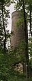
The Ith Tower in the Krüllbrink area (2007)
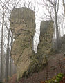
Adam and Eve cliffs

Stone block on the crest of the Ith

Sloping forest in the Ith am Ithkopf


Sport and tourism


The Ith is a tourist attraction especially for hikers , climbers and glider pilots . The Ith-Kammweg attracts many day-trippers, especially during the spring bloom, because of the large populations of anemones and lark spurs. Several hiking trails are well marked on the Ith heights . The section Bisperode - Holzen of European long-distance route E11 runs on the Ithkamm.
A part of the numerous and striking rock formations (“cliffs”) along the Ith ridge is open for climbing. With the Lüerdissen cliffs up to 30 meters high and many other rocks, the Ith is considered the most popular climbing area in Lower Saxony. Almost all rocks are called by name; for example, there are “Adam and Eve”, the “camel”, the “devil's kitchen”, a “monk stone”, the “toad head”, the “Garwindelstein” and many others.
traffic
Streets
The Ith is crossed by two roads: in the north by the state road 425, which runs roughly in a south-west-north-east direction from Haus Harderode near Harderode over the Lauensteiner Pass to Lauenstein, and in the south by the B 240 , which runs from Lüerdissen over the Holzener Pass to Capellenhagen runs.
Ithwiesen special airfield
At the southern end of the ridge, north of the municipality of Holzen - to be reached via the Holzener Pass (B 240) - the " Ithwiesen special landing site " used by the Ithwiesen air sports association is located below the 395 meter high Rothenstein .
An airfield has existed on the Ith ridge since the early 1930s. In 1942 the National Socialist Air Corps established the “Reichssegelflugschule Ith” in Holzen-Ith. Many pilots received their basic flying training there until the end of the war. After the end of the war, the British occupying forces used the site as a “rest center”, a kind of recreation center. In 1949 the "AHQ Gliding Club", which also included up to 30 active RAF pilots , took over training on the premises. On April 6, 1964, the Royal Air Force left the position on the Ith and handed it over to the British Army. In 1971 the first civil service school in Germany was set up in these buildings , the "civil service school I". Today's special landing site is located a little southeast of the original site and no longer uses the old buildings.
On the Ith, but not directly on the Ith heights, there are two other glider airfields: the "Hellenhagen" airfield in Halle - Bremke and the "Bisperode-West" airfield in Bisperode.

A German army helicopter crashed in 1979
On June 8, 1979, a type SE.3130 Alouette II Bundeswehr helicopter was on the flight from Putlos military training area via Celle-Wietzenbruch to Fritzlar . At around 2 p.m. there was a turbine damage at around 100 meters altitude, the helicopter crashed at the 400 meter high Rothenstein on the Ith airfield and exploded. The pilot, Oberfeldwebel Klaus Masson from Army Aviation Squadron 12 in Niederstetten , and the commander of the 352 Panzer Grenadier Battalion based in Mellrichstadt, Lieutenant Colonel Ernst-August Rust, and his staff officer, Lieutenant Reinhold Drescher, perished. Since June 8, 1987 the victim has been commemorated by a memorial stone on the Ith, the ceremonial inauguration of the memorial took place on September 10, 1987. The former armored artillery battalion 15 in Stadtoldendorf took over the sponsorship and responsibility for the memorial.
Small plane crash in 2017
On December 8, 2017, a two-seater small aircraft of the Aquila A 210 type crashed into a cliff of the Ith on the way from Osnabrück to Braunschweig in foggy weather, whereby the pilot died. The crash was noticed by the break in radio contact and the disappearance on the radar screen near Fischbeck , without the knowledge of the crash site about 15 km further east. The aircraft accident led to one of the largest search operations in the Hameln-Pyrmont district with around 400 emergency services from the police, fire brigade and THW using helicopters with thermal imaging cameras , rescue dogs and drones . The plane wreck was discovered by a jogger after two days.
additional
During the Nazi era, the Hameln prison was evacuated at the end of the war . The Schutzstaffel (SS) launched on April 5, 1945, the evacuation of the prison and the march of the prisoners to the outdoor camp near Eschershausen . For many prisoners this march became a death march along the Ith.
literature
- Federal Institute for Regional Studies and Spatial Research: Geographical regional survey 1: 200000. Natural division of Germany. The natural space units on sheet 86 Hanover. Bad Godesberg 1960.
- Hans-Jürgen Klink: Natural structure of the Ith-Hils-Bergland. Federal Research Institute for Regional Studies and Spatial Research, 1966, DNB 457232056 .
- Friedmut Lehmeier: Regional geomorphology of the northern Ith-Hils mountainous region on the basis of large-scale geomorphological mapping. Goltze Druck, Göttingen 1981, ISBN 3-88452-078-4 .
- Michael Geschwinde : Caves in the Ith. Prehistoric places of sacrifice in the mountainous region of southern Lower Saxony. o. O. 1988, ISBN 3-7848-1233-3 .
- Richard Goedeke : Weser-Leine-Bergland. Verlag J. Berg, Munich 1991, ISBN 3-7634-1049-X (on Ith, pp. 76-217)
- Ludger Feldmann, Hans Joachim Franzke, Rainer Müller: The geological development of the lowlands and the low mountain ranges in Lower Saxony. In: Publications of the Academy for Geosciences in Hanover. 20/2002, pp. 8-19.
- Andreas Reuschel: The Ith cliffs through the ages - hiking destination, climbing destination, nature conservation? In: Yearbook for the district of Holzminden Volume 28/29. Holzminden 2010, pp. 121-136.
- Ernst Andreas Friedrich : The caves in the Ith. In: If stones could talk. Volume I, Landbuch-Verlag, Hannover 1989, ISBN 3-7842-0397-3 , pp. 23-25.
- District of Holzminden: On the upswing of the Ith. Air sports on the Ithwiesen since 1930, Verlag Jörg Mitzkat, Holzminden 2016, ISBN 978-3-95954-011-7 .
Web links
- Nature reserve "Ith" in the database of the Lower Saxony State Office for Water Management, Coastal and Nature Conservation (NLWKN)
Individual evidence
- ^ Sofie Meisel: Geographical land survey: The natural space units on sheet 86 Hanover. Federal Institute for Regional Studies, Bad Godesberg 1962. → Online map (PDF; 4.0 MB)
- ^ Jürgen Hövermann: Geographical land survey: The natural space units on sheet 99 Göttingen. Federal Institute for Regional Studies, Bad Godesberg 1963. → Online map (PDF; 4.1 MB)
- ↑ a b Map services of the Federal Agency for Nature Conservation ( information )
- ^ Dierk Hennigsen, Gerhard Katzung: Introduction to the geology of Germany. Spektrum Akademischer Verlag, 7th edition. 2006, ISBN 3-8274-1586-1 , pp. 121-124.
- ↑ a b Caves in the Ith , in Der Ith and the surrounding area , on showcaves.com
- ↑ Ith quarry is now to become a landfill at Focus Online from May 24, 2019
- ^ Garbage dump on the Ith: Citizens' initiative continues to fight at ndr.de from December 20, 2019
- ↑ Petition to prevent landfill for construction waste in the Ith at Welt Online from August 24, 2019
- ^ "Ith" nature reserve (HA 214), at the Lower Saxony State Office for Water Management, Coastal and Nature Conservation , at nlwkn.niedersachsen.de
- ^ "Ithwiesen" nature reserve (HA 213), at the Lower Saxony State Agency for Water Management, Coastal and Nature Conservation, at nlwkn.niedersachsen.de
- ↑ Nature reserve "Saubrink / Oberberg Natural Forest" (HA 097), at the Lower Saxony State Office for Water Management, Coastal and Nature Conservation, on nlwkn.niedersachsen.de
- ↑ Nature reserve "Pöttcher Grund" (HA 068), at the Lower Saxony State Office for Water Management, Coastal and Nature Conservation, on nlwkn.niedersachsen.de
- ↑ FFH areas in Lower Saxony , at the Lower Saxony State Agency for Water Management, Coastal and Nature Conservation, March 2006, on nlwkn.niedersachsen.de (PDF; 79.4 kB)
- ^ Ith ridge hike, on weserbergland.com
- ↑ Topographic map with the Ith ( Memento of the original from December 22, 2015 in the Internet Archive ) Info: The archive link was automatically inserted and not yet checked. Please check the original and archive link according to the instructions and then remove this notice. , on natur-erleben.niedersachsen.de
- ↑ Lüerdissener Cliffs. , on ig-klettern-niedersachsen.de
- ↑ Falko Niederstadt: Three letters, seen differently. ( Memento from September 18, 2008 in the Internet Archive )
- ↑ plane crash on Ith in Dewezet from December 11, 2017
- ↑ Plane crash: Police provide details in the Daily Gazette on December 9, 2017
- ^ Rescue after a plane crash on the Ith at the THW local branch in Hameln on December 10, 2017