Lüerdissen
| coat of arms | Germany map | |
|---|---|---|

|
Coordinates: 51 ° 57 ' N , 9 ° 38' E |
|
| Basic data | ||
| State : | Lower Saxony | |
| County : | Holzminden | |
| Joint municipality : | Eschershausen-Stadtoldendorf | |
| Height : | 150 m above sea level NHN | |
| Area : | 6.89 km 2 | |
| Residents: | 398 (Dec. 31, 2019) | |
| Population density : | 58 inhabitants per km 2 | |
| Postal code : | 37635 | |
| Area code : | 05534 | |
| License plate : | HOL | |
| Community key : | 03 2 55 028 | |
| Association administration address: | Kirchstrasse 4 37627 Stadtoldendorf |
|
| Website : | ||
| Mayor : | Alfred Thies ( SPD ) | |
| Location of the community Lüerdissen in the district of Holzminden | ||
Lüerdissen is a municipality in the northern district of Holzminden in Lower Saxony ( Germany ) and is part of the Eschershausen-Stadtoldendorf municipality .
geography
The Ith , the longest range of cliffs in Northern Germany, is located in part of the municipality . Here are the up to 30 m high Lüerdisser cliffs, probably the most popular climbing area in Lower Saxony.
history
In the Middle Ages the place was documented several times from 1154. In 2006 the community had 575 inhabitants.
Incorporations
On January 1, 1973 the neighboring community of Oelkassen was incorporated.
politics
Municipal council
After the local elections on September 11, 2011 , the municipal council consists of:
mayor
Alfred Thies ( SPD )
Attractions
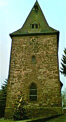
The local chapel was mentioned in a document in 1382 as belonging to the Diocese of Hildesheim . At that time, the noblemen of Homburg founded a vicarie in the chapel and equipped it with a courtyard in Scharfoldendorf, among other things . In terms of architecture, it is a type of choir tower chapel, which is rare in this region . The keystone in the tower shows the lion of the nobles of Homburg as a stone carving.
The Ith-Kammweg leads to the striking, up to 30 m high Lüerdissener cliffs.
Individual evidence
- ↑ State Office for Statistics Lower Saxony, LSN-Online regional database, Table 12411: Update of the population, as of December 31, 2019 ( help ).
- ^ Federal Statistical Office (ed.): Historical municipality directory for the Federal Republic of Germany. Name, border and key number changes in municipalities, counties and administrative districts from May 27, 1970 to December 31, 1982 . W. Kohlhammer GmbH, Stuttgart / Mainz 1983, ISBN 3-17-003263-1 , p. 211 .
- ^ Hermann Adolf Lüntzel : The older diocese of Hildesheim. Gerstenberg , Hildesheim 1837, p. 286 ( available online at Google Books ).
- ↑ kletterdorf.de, listing the Lüerdissener cliffs


