
Brevörde
| coat of arms | Germany map | |
|---|---|---|

|
Coordinates: 51 ° 55 ' N , 9 ° 25' E |
|
| Basic data | ||
| State : | Lower Saxony | |
| County : | Holzminden | |
| Joint municipality : | Bodenwerder pollen | |
| Height : | 97 m above sea level NHN | |
| Area : | 13.59 km 2 | |
| Residents: | 595 (Dec. 31, 2019) | |
| Population density : | 44 inhabitants per km 2 | |
| Postcodes : | 37647, 37639 | |
| Area code : | 05535 | |
| License plate : | HOL | |
| Community key : | 03 2 55 005 | |
| LOCODE : | DE EVO | |
| Association administration address: | Münchhausenplatz 1 37619 Bodenwerder |
|
| Website : | ||
| Mayor : | Winfried Hoch | |
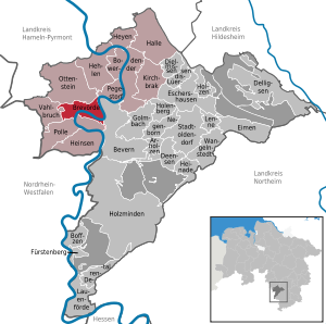
| Location of the municipality of Brevörde in the district of Holzminden | ||
  |
||

Brevörde is a municipality in the district of Holzminden in Lower Saxony (Germany). It belongs to the joint municipality of Bodenwerder-Polle .
geography
location
Brevörde is located within the Weser Uplands in the Upper Weser Valley , about 9.5 km southwest of Bodenwerder and 9 km (as the crow flies ) north-northwest of Holzminden . It is located on the orographic left and north bank of the Weser , which makes two U-shaped river loops (valley meanders) there. From 85 to 130 m above sea level Viewed from the district of Grave located at NHN , the landscape leads north to the steeply rising Kleff (approx. 281 m ), a southern edge of the Ottenstein plateau . A few kilometers to the east, beyond Grave and the Weser that runs there, the Solling-Vogler Nature Park extends . The western districts are traversed by the Brevörder Bach ( Glesse ), which flows into the Weser immediately afterwards and after crossing under the federal highway 83 , which runs through the village .
Community structure
The municipality of Brevörde consists of the main town of the same name and the eastern neighboring town of Grave . The municipality also includes the hamlet Brille , which lies on the other side of the Weser around 1.5 km south of the Grave district and around 500 m west of Reileifzen .
history
Brevörde ("wide ford ") is an old settlement at a ford in the Weser .
During the time of the Kingdom of Westphalia (1810-1813), Brevörde belonged to the canton of Bodenwerder . From April 1, 1922, it was part of the Hameln-Pyrmont district . As part of the regional reform in Lower Saxony , the community was incorporated into the Holzminden district on January 1, 1973 , with Grave being incorporated. Since 1973 Brevörde has belonged to the joint municipality of Polle or to the joint municipality of Bodenwerder-Polle , in which it was merged in 2010.
In recent times, numerous old buildings have been demolished to widen the B 83.
Monastery and village church
In the past, Brevörde was subordinate to the Kemnade monastery, founded around 960 in nearby Kemnade (today's district of Bodenwerder) . The Urbankirche , named after St. Urban , built around 1200, is one of the Evangelical Lutheran regional churches of Hanover and is the village's landmark. It has a gable roof and a medieval tower with stepped gables on both sides . The church interior is a simple hall with an organ built by Andreas Schweimb and purchased in 1815 , in which medieval documents came to light during a restoration in the 1980s. The church building used to be the mother church of Polle. The church belongs to the parish Hehlen-Hohe within the parish of Holzminden-Bodenwerder and is also provided for by the pastor of Polle.
Population development
- 1824: 73 fireplaces
- 1925: 433 inhabitants
- 1933: 421 inhabitants
- 1939: 395 inhabitants
- 1961: 931 inhabitants, 396 of them in Grave
- 1970: 861 inhabitants, 372 of them in Grave
- 1996: 851 inhabitants
- 2006: 759 inhabitants
- 2008: 757 inhabitants
- 2010: 721 inhabitants
- 2011: 718 inhabitants
- 2017: 630 inhabitants
Plane crash
On October 18, 1988, a British F-4 Phantom II fighter plane crashed into a wooded area near Brevörde due to an engine failure. The two pilots, Pete Lines and Colin Fryer, were able to save themselves on a field in Meiborssen with the ejection seat . The combined municipality of Polle then demanded from the federal government in November 1988 a ban on low-level flights in the Upper Weser region.
politics
Municipal council
Turnout: 75.29%.
After the local elections on September 11, 2011 , the municipal council consists of:
Local elections 2016:
- SPD: 6
- CDU: 3rd
coat of arms
- Description of coat of arms
- "A black tower with a stepped gable on silver over double, blue wave beams"
traffic
Streets
Brevörde lies between Pegestorf and Polle on the federal road 83 , which runs in the Höxter region - passing Holzminden on the other side of the Weser (accessible via the B 64 branching off from the B 83 ) - to Bodenwerder . From the B 83, the branches on the eastern village exit State Road 428 from the serpentine rich over the Kleff northwest of lying on the Ottenstein Plateau Ottenstein leads. About 1 km north-east of this outskirts, district road 36 branches off from the B 83 , which runs as a spur road to and through the district of Grave and ends directly afterwards at the jetty for the Weser ferry Grave .
Weser ferry Grave
In the district of Grave, the Weser ferry Grave ( Gravena ) has been operating since 2005 after the earlier ferry service was closed in 1977 . It brings hikers and cyclists from the west bank there ( Kreisstraße 36; B 83 – Grave) to the other bank (K 35; Dölme - Reileifzen ) of the river; The Weser cycle path runs along the east bank and connects to the nearby R1 European cycle path .
literature
- Considerations on the origin of the organ in Brevörde , in: Ars Organi 4/2006, p. 217 ff.
- F. Schreiber: Medieval text fragments found in the organ of St. Urban Church in Brevörde. Preliminary report on the current status of the results , in: Yearbook 1987/88 for the district of Holzminden Volume 5/6, pp. 44–54
- Mark Rauschkolb: Two flint axes from Brevörde and Meiborssen. In: Yearbook 1987/88 for the district of Holzminden Volume 7 (1989), pp. 23-25
- St. Urban in Brevörde, in: Churches in the Ev.-luth. Church district Holzminden-Bodenwerder, 2006, p. 10
Individual evidence
- ↑ State Office for Statistics Lower Saxony, LSN-Online regional database, Table 12411: Update of the population, as of December 31, 2019 ( help ).
- ↑ Map services of the Federal Agency for Nature Conservation ( information )
- ↑ a b c Federal Statistical Office (ed.): Historical municipality directory for the Federal Republic of Germany. Name, border and key number changes in municipalities, counties and administrative districts from May 27, 1970 to December 31, 1982 . W. Kohlhammer, Stuttgart / Mainz 1983, ISBN 3-17-003263-1 , p. 195 .
- ↑ https://wahlen.kdgoe.de/historie/2016kw/Daten/255408_000045/0002550050000_Gremium.html
- ↑ Samtgemeinde Polle - Brevörde ( Memento of the original from October 6, 2007 in the Internet Archive ) Info: The archive link was inserted automatically and has not yet been checked. Please check the original and archive link according to the instructions and then remove this notice.
Web links
Arholzen | Bevern | Bodenwerder | Boffzen | Brevörde | Deensen | Delligsen | Derental | Dielmissen | Buckets | Eschershausen | Fürstenberg | Golmbach | Hall | Caves | Heinade | Heinsen | Heyen | Holenberg | Wood | Holzminden | Kirchbrak | Lauenförde | Lenne | Lüerdissen | Negenborn | Ottenstein | Pegestorf | Pollen | Stadtoldendorf | Vahlbruch | Wangelnstedt
Unregulated areas in the district of Holzminden
Boffzen |
Buckets |
Eschershausen |
Green plan |
Holzminden |
Merxhausen |
Wenzen