
Heinade
| coat of arms | Germany map | |
|---|---|---|

|
Coordinates: 51 ° 50 ' N , 9 ° 38' E |
|
| Basic data | ||
| State : | Lower Saxony | |
| County : | Holzminden | |
| Joint municipality : | Eschershausen-Stadtoldendorf | |
| Height : | 303 m above sea level NHN | |
| Area : | 9.07 km 2 | |
| Residents: | 849 (Dec. 31, 2019) | |
| Population density : | 94 inhabitants per km 2 | |
| Postal code : | 37627 | |
| Primaries : | 05532, 05564 | |
| License plate : | HOL | |
| Community key : | 03 2 55 018 | |
| Community structure: | 3 districts | |
| Association administration address: | Kirchstrasse 4 37627 Stadtoldendorf |
|
| Website : | ||
| Mayor : | Gerhard Ross (Heinade Voting Association) | |
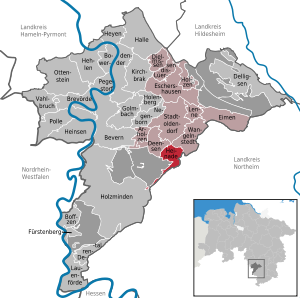
| Location of the Heinade community in the Holzminden district | ||
  |
||

Heinade is a municipality in the district of Holzminden in Lower Saxony ( Germany ). It belongs to the integrated community of Eschershausen-Stadtoldendorf , which has its administrative seat in the city of Stadtoldendorf .
geography
location
Heinade lies between the towns of Dassel in the southeast, Holzminden in the west and Stadtoldendorf in the north on the eastern edge of the Solling-Vogler Nature Park . The community is located north of the Solling , south-southwest of the Holzberg and west of the Amtsberge . The village is located in the headwaters of the Spüligbach , a northwest tributary of the Ilme .
Community structure
Three districts are identified for the community:
- Heinade (with Pilgrim)
- Hellental
- Merxhausen
history
The time when Heinade was founded and the beginning of continuous settlement are unknown. The place name could indicate a relatively old place, the documentary tradition begins relatively late: A documented mention of a place called Henede from 1272, which is sometimes assigned to Heinade, could also refer to Heinde . The first reliable mention comes from the Homburg Lehnsregister around the year 1300, the place is referred to here as in later documents as Heina . The ending -ade has only been handed down since the end of the 16th century.
Heinade was a state-approved resort until the end of 2010 .
- Incorporations
On January 1, 1973, the communities Hellental and Merxhausen were incorporated.
politics
Municipal council
The turnout was 70.53%.
After the local elections on September 11, 2011 , the municipal council consists of:
- Community of voters Heinade-Merxhausen-Hellental (WG HMH): 6 seats
- SPD : 3 seats
mayor
The honorary mayor Gerhard Ross (WG HMH) was elected at the constituent meeting of the council on November 6, 2011. Until then, he held the post of deputy mayor. The previous mayor Heinrich Schoppe withdrew from municipal politics after more than 40 years.
traffic
Heinade is located on Landstrasse 580 which leads from Dassel to Negenborn and meets Bundesstrasse 64 there. In the center of Merxhausen, Kreisstraße 48 is the only public road to Hellental.
Culture and sights
church

The church was built in 1823. It replaced a church building erected in 1624 instead of an older chapel, which had been demolished in 1822 due to dilapidation. The church, which today belongs to the Holzminden-Bodenwerder parish , was renovated in 1890 and 1956. In 1954, Friedrich Weißenborn installed a used Faber organ in a technically and sonically modified form behind the historic organ prospectus of the Euler company. Today's disposition is:
| I. Manual C-f3 | II. Manual C-f3 | Pedal C-d1 |
|---|---|---|
| Wooden 8 ' | Lovely Gedackt 8 ' | Subbass 16 ' |
| Principal 4 ' | Pointed flute 4 ' | Principal bass 8 ' |
| Small box 4 ' | Forest flute 2 ' | Octave bass 4 ' |
| Octave 2 ' | Fifth 1 1/3 ' | |
| Terzian 2 times | ||
| Mixture 4 times |
societies
- Local history and history association Heinade - Hellental - Merxhausen (HGV-HHM)
- Gymnastics and sports club Heinade from 1897
- SK Heinade (shooting club)
Personalities
- Hermann Reuter (1870–1934), lawyer in the Imperial Navy and the Imperial Navy
- Paul Jorns (1871–1942), Prussian. Court martial in the army justice service, public prosecutor at the People's Court and from 1936 senior Reich lawyer
Individual evidence
- ↑ State Office for Statistics Lower Saxony, LSN-Online regional database, Table 12411: Update of the population, as of December 31, 2019 ( help ).
- ↑ http://www.uni-goettingen.de/admin/bilder/pictures/e96330b0832b51ab4964dc4c8ab0474d.jpg
- ↑ Kirstin Casemir and Uwe Ohainski: The place names of the district of Holzminden . Publishing house for regional history, Bielefeld 2007. ISBN 978-3-89534-671-2 , p. 106 f.
- ^ Federal Statistical Office (ed.): Historical municipality directory for the Federal Republic of Germany. Name, border and key number changes in municipalities, counties and administrative districts from May 27, 1970 to December 31, 1982 . W. Kohlhammer GmbH, Stuttgart / Mainz 1983, ISBN 3-17-003263-1 , p. 211 .
- ↑ Wolfgang F. Nägeler, Klaus AE Weber: History and residents between Solling and Holzberg, 2005, p. 239
Web links
Arholzen | Bevern | Bodenwerder | Boffzen | Brevörde | Deensen | Delligsen | Derental | Dielmissen | Buckets | Eschershausen | Fürstenberg | Golmbach | Hall | Caves | Heinade | Heinsen | Heyen | Holenberg | Wood | Holzminden | Kirchbrak | Lauenförde | Lenne | Lüerdissen | Negenborn | Ottenstein | Pegestorf | Pollen | Stadtoldendorf | Vahlbruch | Wangelnstedt
Unregulated areas in the district of Holzminden
Boffzen |
Buckets |
Eschershausen |
Green plan |
Holzminden |
Merxhausen |
Wenzen