Official Mountains
| Official Mountains | |
|---|---|
|
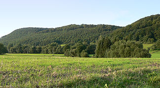
The Amtsberge between Stadtoldendorf and Einbeck |
|
|
Part of the official mountains; the middle elevation is the location of the Hunnesrück castle ruins (view from Dassel ) |
|
| Highest peak | Belzerberg ( 392.2 m above sea level ) |
| location | at Dassel ; District Northeim , Lower Saxony ( Germany ) |
| Lower Saxony highlands |
Weser-Leine-Bergland ; Weser and Leinebergland |
| Coordinates | 51 ° 51 ' N , 9 ° 41' E |
| rock | Limestone , marl , sandstone |
| Age of the rock | Shell limestone , Keuper |
The Amtsberge are a smaller area, up to 392.2 m above sea level. NN high ridge of the Weser-Leine mountains . It is located near Dassel in the district of Northeim ( Germany ) in Lower Saxony .
geography
location
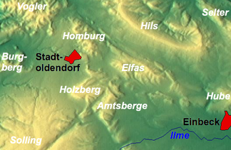
The Amtsberge lie directly on the seam line of the districts of Northeim (predominant part of the ridge with its summit location) and Holzminden (north-western part) as well as of Leinebergland in the east and Weserbergland in the west. They are located northeast of the Solling , so they belong to its foothills . Somewhat north-north-west of the ridge lies the Homburgwald and north-northeast of the ridge of Elfas . The Holzberg ridge and the Heukenberg spread to the northwest , from which the Amtsberge are only separated by the Teichbach valley near Denkiehausen . To the southeast, beyond the Ilme , joins the Ellenser Forest . The closest towns are Stadtoldendorf in the northwest and Dassel in the south-southeast.
Several brooks arise within the Amtsberge and belong to the catchment area of the Weser and Leine . The north-west foothills of the ridge are passed by the upper reaches of the Lenne flowing in a north-westerly direction (eastern tributary of the Weser), the southern foothills are passed by the south-east running central reaches of the Spüligbach (north-western tributary of the Ilme ) and the eastern ones by a tributary into the central reaches of the Bewer .
Except for the northern part of the deciduous forest ridge with its summit location, parts of the Sollingvorland bird sanctuary (VSG no. 4022-431; 168.85 km² ), which is subject to the EU bird protection directive, extend .
Natural allocation
The Amtsberge form - together with the mountain ranges Holzberg in the northwest and Ellenser Wald in the southeast - in the natural spatial main unit group Weser-Leine-Bergland (No. 37), in the main unit Solling foreland (371) and in the subunit Northern Solling foreland (371.0) the nature area Amtsberge (371.04). The landscape leads to the north-west into the natural area Stadtoldendorfer plateau (371.02) and to the north-north-east into the natural area Elfasumland (371.06). In the south-west of the main unit Solling, Bramwald and Reinhardswald (370) is part of the sub-unit Northern Solling (370.0).
Surveys
The surveys of the Amtsberge include - with heights in meters (m) above sea level (NN):
|
|
Flowing waters
The rivers in and around the Amtsberge include:
- Bewer (northwest tributary of the Ilme )
- Lenne (eastern tributary of the Weser )
- Reissbach (western tributary of the Bewer)
- Spüligbach (northwest tributary of the Ilme)
- Teichbach (northern tributary of the Spüligbach)
Localities
Localities in and on the official mountains are:
- Dassel - in the south
- Heinade - in the west
- Stadtoldendorf - in the northwest
- Wangelnstedt - in the north
Surname
Johannes Krabbe called the ridge in his map of the Solling 1603 "Hundesrucke", so that it was assumed that this was an indication of the mountain silhouette curved in the shape of a dog's back. Comparable names were documented to refer to Hunnesrück Castle since 1310 . Johannes Letzner suspected a protective device against the Huns here . Christian Gottfried Daniel Stein wrote that the name was derived from the Hünen who lived there.
A more recent etymological interpretation assumes that the name comes from the Old High German word "huno"; accordingly , a judge's office was already exercised here in Carolingian times, when the area was in Suilbergau .
After Hunnesrück Castle was demolished, the reference to the Hunnesrück Office prevailed.
Worth seeing
The forest landscape with its hiking trails is one of the sights of the Amtsberge. In a forest area in the south of the ridge north of Dassel between Mackensen and Hunnesrück are the ruins of Hunnesrück Castle above the donkey pond . The stone Passion Cross from the 18th century of the parishioners in the Hunnesrück Chapel is erected near the castle ruins .
- Boundary stone west of the White Mill
The political border between the districts of Northeim and Holzminden, which runs through the Amtsberge, corresponds to the former border between the Kingdom of Hanover and the Duchy of Braunschweig . A boundary stone from this time has been preserved on the county road halfway between Mackensen and Denkiehausen . From there, in an easterly direction, to the Teichbach at the foot of the Amtsberge, the Landwehr of that time can be seen as a strip of soil that is around 15 m wide and up to 1 m higher. The intersection of the Landwehr and Teichbach marks the former location of the White Mill east of the Teichbach. In addition, remains of the up to 300 m long mill canal and the attack on the mill wheel can be found there. The White Mill was a grinding mill and was first mentioned in 1692 after August II had rejected a building application made in 1663. In 1928 the now disused mill was torn down after it had been used as a residence for workers for a few years.
Individual evidence
-
↑ a b Hiking and leisure in the Solling-Vogler Nature Park , topographic map (1: 50,000; 1975),
publisher : Lower Saxony State Administration Office - State surveying - ↑ World Database on Protected Areas - Sollingvorland Special Protection Area (Birds Directive) (English)
- ↑ Map services of the Federal Agency for Nature Conservation ( information )
- ^ Jürgen Hövermann: Geographical land survey: The natural space units on sheet 99 Göttingen. Federal Institute for Regional Studies, Bad Godesberg 1963. → Online map (PDF; 4.1 MB)
- ↑ Belzerberg: with a trigonometric point ( 375.6 m ) on the northwest slope (according to the referenced map hiking and leisure in the Solling-Vogler Nature Park ; 1975)
- ↑ JEB: Compendieuse Staats-Description des Durchlauchtigen Welt-Kreises , Zweyter Theil , 1720, p. 140, on books.google.de
- ^ Christian Gottfried Daniel Stein: Geographical-statistical newspaper, post and Comtoir-Lexicon: F – H , 1819, p. 452, on books.google.de
- ↑ Hans-Norbert Mittendorf: On the cultural history of today's Dassel urban area in the mirror of old field names , 1991, pp. 130, 235
- ↑ Collection of Old and Middle German words from Latin documents , 1863, p. 14, on books.google.de
- ↑ Christ cross next to the Hunnesrück castle ruins renovated by the Pilates Brotherhood, in: Weser-Ith News online from July 5, 2014
- ↑ Wolfgang Anders, Detlef Creydt: Das Rittergut Denkiehausen and the White Mill, in: Yearbook for the district of Holzminden, 2004, pp. 99-106


