Holzberg (mountain range)
| Holzberg | |
|---|---|
|
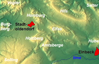
The Holzberg with neighboring heights near Stadtoldendorf |
|
|
View from the north of the Holzberg ridge |
|
| Highest peak | Holzberg ( 444.5 m above sea level ) |
| location | near Stadtoldendorf , Holzminden district , Lower Saxony ( Germany ) |
| Lower Saxony highlands |
Weser-Leine-Bergland ; Leine and Weser Uplands |
| Coordinates | 51 ° 51 ' N , 9 ° 38' E |
| rock | Limestone , sandstone |
| Age of the rock | Shell limestone , red sandstone |
The Holzberg is a smaller area, up to 444.5 m above sea level. NHN high ridge of the Weser-Leine mountains . It is located near Stadtoldendorf in the Holzminden district in Lower Saxony .
geography
location
The Holzberg ridge is located in the Holzminden district on the junction of Leinebergland in the east and Weserbergland in the west. It is located northeast of the Solling between Stadtoldendorf in the northwest, the Homburgwald in the north, the Elfas in the northeast, the Amtsbergen in the southeast, from which it is only separated by the valley of the Teichbach near Denkiehausen , and Dassel in the southeast.
In the Holzberg ridge, the eastern part of which is called Denkiehäuser Wald , several streams arise that sooner or later become tributaries of the Leine and Weser . Its northern foothills are drained by the Weser tributary Lenne , which rises here and flows to the northwest , the eastern from the Spüligbach tributary Teichbach, the southern from the upper reaches of the Ilme tributary, Spüligbach, and the western from the Forstbach tributary Eberbach.
Natural allocation
The Holzberg belongs - together with the Amtsberge ridge to the southeast and the Ellenser Forest beyond it - in the natural spatial main unit group Weser-Leine-Bergland (No. 37), in the main unit Solling foreland (371) and in the subunit Northern Solling foreland ( 371.0) to the nature area Amtsberge (371.04). The landscape leads to the northwest into the natural area Stadtoldendorfer plateau (371.02) and to the northeast into the natural area Elfasumland (371.06). In the south-west of the main unit Solling, Bramwald and Reinhardswald (370) is part of the sub-unit Northern Solling (370.0).
Surveys
The surveys of the Holzberg ridge include - sorted by height in meters (m) above mean sea level (NN) or sea level (NN):
- Holzberg (444.5 m) - on the southern rocky slopes of the Holzberg
- nameless elevation (441.3 m) - south of the (western) cliffs
- nameless elevation (436.0 m) - south of the (western) cliffs
- nameless elevation (405.4 m) - in the middle part of the Holzberg
- nameless elevation (397.0 m) - northeast of the (western) cliffs
Flowing waters
The rivers in and on the Holzberg ridge include:
- Eberbach - southwestern source stream of the Forstbach
- Lenne - eastern tributary of the Weser ; rises on the northern edge of Holzberg
- Spüligbach - north-western tributary of the Ilme; rises on the southern edge of Holzberg
- Teichbach - northern tributary of the Spüligbach
Localities
Localities on the Holzberg ridge are:
- Dassel - in the southeast
- Deensen - in the west
- Braak - in the southwest
- Heinade - in the south
- Linnenkamp - in the northeast
- Stadtoldendorf - in the north
- Wangelnstedt - in the northeast
Protected areas
Parts of the nature reserve Holzbergwiesen ( CDDA no. 163781; designated 1991; 3.75 km² in size), the protected landscape area of Northwestern Holzberg (CDDA no. 323286; 1956; 1.22 km²) and fauna extend to the flanks of the wooded Holzberg -Flora-Habitat -Area Holzberg near Stadtoldendorf, Heukenberg (FFH no. 4123-301; 7.81 km²). Parts of the Sollingvorland bird sanctuary (VSG no. 4022-431; 168.85 km²) are located on the ridge and are subject to the EU bird protection directive .
Biotopes such as lean meadow , spring moor or beech forest are habitat for endangered animal and plant species such as the narrow diaper snail , the scaly yellow sedge or the broad-leaved cotton grass as well as for bird species worthy of protection such as gray woodpecker , red kite or eagle owl .
Worth seeing
The sights of the Holzberg ridge include the forest landscape (interesting flora on the limestone soil ) and the “ cliffs ” east of Braak (district of Deensen) and steeply sloping down to this village.
Individual evidence
- ↑ a b c d Map services of the Federal Agency for Nature Conservation ( information )
- ^ Jürgen Hövermann: Geographical land survey: The natural space units on sheet 99 Göttingen. Federal Institute for Regional Studies, Bad Godesberg 1963. → Online map (PDF; 4.1 MB)
-
↑ a b c d e f Hiking and leisure in the Solling-Vogler Nature Park , Topographische Karte (1: 50,000; 1975),
publisher : Lower Saxony State Administration Office - State survey - ↑ World Database on Protected Areas - Holzberg bei Stadtoldendorf, Heukenberg Site of Community Importance (Habitats Directive) (English)
- ↑ World Database on Protected Areas - Sollingvorland Special Protection Area (Birds Directive) (English)


