Elfas
| Elfas | |
|---|---|
|
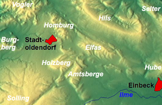
The Elfas between Stadtoldendorf and Einbeck |
|
| Highest peak | Helleberg ( 409.6 m above sea level ) |
| location | Districts of Holzminden and Northeim ; Lower Saxony ( Germany ) |
| Lower Saxony highlands |
Leinebergland in the Weser-Leine-Bergland |
| Coordinates | 51 ° 53 ' N , 9 ° 44' E |
| rock | Sandstone |
| Age of the rock | Red sandstone |
The Elfas is one to 409.6 m above sea level. NHN high low mountain range of the Leinebergland in the Weser-Leine-Bergland . It is located in the districts of Holzminden and Northeim in Lower Saxony .
The name of the mountain range is derived from the Low German word Fast, which means a height that descends on two sides.
geography
location
The Elfas is located in the middle part of the Leinebergland between the low mountain ranges and mountain ranges Hils in the north, Homburgwald in the west, Hube in the east, Amtsberge in the south-southwest and Holzberg in the southwest.
Geologists combine the Elfas with the Homburgwald and the Vogler to form the Elfas axis , as these lie along a line.
The tops of the Elfas are planted with acidic beech forests. The Sollingvorland bird sanctuary extends to its western and northern parts (VSG no. 4022-431; 168.85 km² ).
Natural allocation
The low mountain range forms the natural area of Elfas (371.05) in the natural spatial main unit group Weser-Leine-Bergland (No. 37), in the main unit Solling foreland (371) and in the subunit Northern Solling foreland (371.0). It is ring-shaped by the natural area Elfasumland (371.06).
In addition, the mountain range belongs to the Leinebergland , which covers the Weserbergland to the east and the Harz to the west, but is not a landscape defined by natural aspects.
mountains
The mountains in Elfas include - sorted by height in meters (m) above sea level (NHN):
|
|
Flowing waters
The rivers in and around the Elfas include:
- Allerbach (eastern tributary of the Bewer)
- Bewer (northern tributary of the Ilme )
- Hillebach (northern tributary of the Krummen water )
- Lenne (passes the Elfas in the west)
geology
The Elfas is essentially made up of sandstones from the time of the red sandstone . By a halo kinetic process, which in Paläogen had already been completed, the migrated Elfasscholle in the direction of the northeast Solling, wherein the mountain-forming sandstone on a layer in zechstein formed Salinars moved. In the process, older layers of rock, which had previously been below, pushed over some of the younger ones, so that, following erosion processes, today's layered landscape emerged as the northern boundary of the Einbeck-Markoldendorfer Basin .
Political structure
The area of the Elfas is divided roughly equally between the communities Dassel and Eimen . Two northwestern foothills are on the municipality of Lenne and Wangelnstedt , the southeastern foothills on the municipality of Einbeck . The villages of Portenhagen and Rengershausen are located at the southern foot of the Elf. In addition to Dassel (southwest) and Einbeck (southeast), Eschershausen (northwest) and Stadtoldendorf (west) are the surrounding cities.
Traffic and walking
North past the Elfas leads through Vorwohle , Mainzholzen and Eimen the federal highway 64 , which crosses the federal highway 3 a little east of the mountain range and north of Einbeck . Several forest, riding and hiking trails lead through the ridge.
Individual evidence
- ↑ a b c Map services of the Federal Agency for Nature Conservation ( information )
- ↑ Georg Schambach: Dictionary of Low German Dialect , 1858, p. 257
- ^ Jürgen Hövermann: Geographical land survey: The natural space units on sheet 99 Göttingen. Federal Institute for Regional Studies, Bad Godesberg 1963. → Online map (PDF; 4.1 MB)
- ↑ Axel Herrmann, Carsten Hinze, Volker Stein: The halokinetic interpretation of the Elfas thrust in the mountainous region of southern Lower Saxony , in: Geologisches Jahrbuch 84 , 1967, p. 407 ff.

