Vogler
| Vogler | ||
|---|---|---|
|
View from the Weser between Bodenwerder and Rühle to the Vogler |
||
| Highest peak | Ebersnacken ( 460.4 m above sea level ) | |
| location | District of Holzminden , Lower Saxony ( Germany ) | |
| part of | Weserbergland | |
|
|
||
| Coordinates | 51 ° 56 ' N , 9 ° 34' E | |
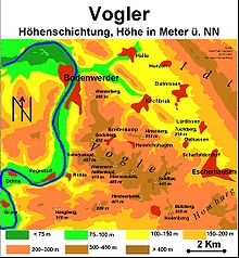
The Vogler is up to 460.4 m above sea level. NN high low mountain range of the Weserbergland in the district of Holzminden , Lower Saxony ( Germany ).
Together with the Solling ( 527.8 m ) located about 20 km to the south and the Burgberg ridge ( 357.5 m ) between the two mountains, it forms the Solling-Vogler Nature Park .
geography
location
The Vogler is located between the low mountain ranges of Ith in the north, Hils in the northeast, Homburgwald in the east, Amtsberge in the southeast, Solling in the south and Burgberg in the south-southwest. It lies in the triangle of cities Bevern - Bodenwerder - Eschershausen . To the west, past the Vogler, the Weser flowing to the North Sea flows in a south-north direction ; to the north, the mountains are passed in a south-east-north-west direction from the eastern Lenne tributary.
The Vogler approaches the Weser in a sudden drop from a height of 220 m . In the northern foothills is Heinrichshagen , where Heinrich I (Heinrich the Vogler) is said to have had his flock of birds .
Natural allocation
The low mountain range forms in the natural spatial main unit group Weser-Leine-Bergland (No. 37), in the main unit Solling foreland (371) and in the subunit Northern Solling foreland (371.0) the natural area Vogler (371.00). The landscape leads to the southeast into the natural area Stadtoldendorfer plateau (371.02) and to the south to southwest into the natural area Golmbacher Berge (371.01). It falls to the west into the subunit Bodenwerder Tal (368.1), which belongs to the main unit group Upper Weserbergland (36) to the main unit Weserengtal of Bodenwerder (368). To the north to northeast it falls into the natural area Eschershausener Triaskämme (377.02), which belongs to the sub-unit Eschershausener Senke (377.0) in the main unit Alfelder Bergland (377) .
Surveys
The mountains and elevations of the Vogler include - sorted according to height in meters (m) above sea level (NN; unless otherwise specified according to):
|
|
Localities
The villages in and on the Vogler include:
geology
The rock that characterizes the Vogler comes from the geological time of the red sandstone . Geologists combine the Vogler with the Homburgwald and the Elfas to form the Elfas axis , as these lie along a line.
Worth seeing
On the Ebersnacken ( 460.4 m ) is the observation tower Ebersnacken , from which the all-round view falls over the Vogler. Other observation towers are the Bodoturm on the Zimmertalskopf ( 412 m ) and the tower on the Königszinne ( 255 m ) built in 1863 on the occasion of the 50th anniversary of the Battle of Leipzig .
Also worth seeing is the Amelungsborn monastery , which is located southeast of the Vogler on the southwest edge of the Odfeld .
Individual evidence
-
↑ a b Hiking and Leisure in the Solling-Vogler Nature Park , Topographical Map (1: 50,000; 1975),
Ed .: Lower Saxony State Administration Office - State Surveying - ^ Jürgen Hövermann: Geographical land survey: The natural space units on sheet 99 Göttingen. Federal Institute for Regional Studies, Bad Godesberg 1963. → Online map (PDF; 4.1 MB)
- ↑ a b Map services of the Federal Agency for Nature Conservation ( information )
- ↑ Friedrich Meissel: The Hameln District - Description, History and Legend, 1899, p. 10


