Burgberg (mountain range)
| Castle Hill | ||
|---|---|---|
|
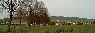
Burgberg, in front of it Bevern (from the southwest) |
||
| Highest peak | Burgberg ( 357.5 m above sea level ) | |
| location | District of Holzminden , Lower Saxony ( Germany ) | |
| part of | Lower Saxony highlands | |
|
|
||
| Coordinates | 51 ° 53 ' N , 9 ° 32' E | |
The castle hill (also called the castle hill ) is one to 357.5 m above sea level. NHN high ridge of the Weser Uplands near Bevern in the Holzminden district .
geography
location
The Burgberg, which belongs to the Solling-Vogler Nature Park , is located between the low mountain ranges Vogler in the north, Homburgwald in the northeast and Solling in the south . It lies between Warbsen in the north, Golmbach in the northeast, Negenborn in the east, Arholzen in the southeast, Lobach in the south, Bevern in the southwest and Forst and the Weser in the west.
A section of the B 64 , which connects Holzminden with Negenborn, runs along the Burgberg to the south .
Natural allocation
The Burgberg belongs to the natural spatial main unit group Weser-Leine-Bergland (No. 37), in the main unit Sollingvorland (371) and in the subunit Northern Solling-Vorland (371.0) to the natural area Golmbacher Berge (south-west roofing of the Vogler and Burgberg; 371.01).
mountains
The mountains and elevations of the Burgberg ridge include - sorted by height in meters (m) above mean sea level (NHN):
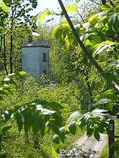
- Burgberg ( 357.5 m ), in the center of the Burgberg (with inaccessible telegraph tower)
- Great Everstein ( 345.2 m ), in the eastern part of the castle hill (with remains of the walls of Everstein Castle )
- Kleiner Everstein ( 312.5 m ), in the eastern part of the castle hill, also with the remains of the walls of Everstein Castle
- Hirschzunge ( 310.4 m ), in the eastern part of the castle hill
- Friedberg ( 308 m ), in the western part of the Burgberg
Flowing waters
The rivers on the Burgberg ridge include (sorted alphabetically):
- Beverbach (in the south and northeast of the Burgberg; eastern tributary of the Weser)
- Forstbach (in the north of the Burgberg; eastern tributary of the Weser)
- Weser (west of the castle hill; stream to the North Sea )
Worth seeing
The sights as well as natural and cultural monuments in the Burgberg ridge include:
On the Great Everstein and the Little Everstein there are remains of the walls of Everstein Castle .
The tower ( ⊙ ) of the former royal Prussian optical telegraph station No. 28, which was part of the Berlin-Koblenz telegraph line, stands on the Burgberg in the middle of the ridge . There are also remains of the foundations of the station building. The tower is not accessible to the public. A display board explains the history of optical telegraphy.
Protected areas
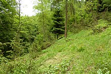
On the south-western part of the castle hill lies the nature reserve Südliche Burgberg slopes ( CDDA -Nr. 165784; designated 1994; 83 hectares ), which extends on its slope towards the Beverbach . On the steep north slope of the ridge is the Frauenschuhfläche , a remnant of the use of the Burgberg slopes as pastures for sheep and goats. The grazing resulted in areas with semi-arid grasslands on which a special flora developed. On its area, which is only partially covered with trees and juniper , grow alongside the woman's slipper from which it is named, among other things, fringed gentian , meadow sage and wild marjoram . The Frauenschuh area is under nature protection and is accessed by a path, a display board provides information about the development and vegetation of the area.
Parts of the protected landscape area Solling-Vogler (CDDA no. 324597; 2002; 242.138 km² ), the fauna-flora-habitat area Burgberg, Heinsener Klippen and Rühler Schweiz (FFH no. 4022-302; 26 , 9583 km²) and the Sollingvorland bird sanctuary (VSG no. 4022-431; 168.85 km²).
Individual evidence
- ↑ a b c d Topographic map with the castle hill ( Memento of the original from March 4, 2016 in the Internet Archive ) Info: The archive link was inserted automatically and has not yet been checked. Please check the original and archive link according to the instructions and then remove this notice. (DTK 25; for referenced mountain heights see large enlargement of the map), on natur-erleben.niedersachsen.de
- ^ Jürgen Hövermann: Geographical land survey: The natural space units on sheet 99 Göttingen. Federal Institute for Regional Studies, Bad Godesberg 1963. → Online map (PDF; 4.1 MB)
- ↑ a b c d Map services of the Federal Agency for Nature Conservation ( information )
- ↑ Birgit Czyppull, Heike Molthan, Dirk Reuter: Landscape Guide Naturpark Solling-Vogler . Wartberg Verlag, Gudensberg-Gleichen 1996, ISBN 3-86134-293-6 , p. 59 f


