
Wangelnstedt
| coat of arms | Germany map | |
|---|---|---|

|
Coordinates: 51 ° 52 ' N , 9 ° 41' E |
|
| Basic data | ||
| State : | Lower Saxony | |
| County : | Holzminden | |
| Joint municipality : | Eschershausen-Stadtoldendorf | |
| Height : | 260 m above sea level NHN | |
| Area : | 15.15 km 2 | |
| Residents: | 555 (Dec. 31, 2019) | |
| Population density : | 37 inhabitants per km 2 | |
| Postal code : | 37627 | |
| Area code : | 05532 | |
| License plate : | HOL | |
| Community key : | 03 2 55 036 | |
| Association administration address: | Kirchstrasse 4 37627 Stadtoldendorf |
|
| Website : | ||
| Mayor : | Marcel Lohmann (WGW) | |
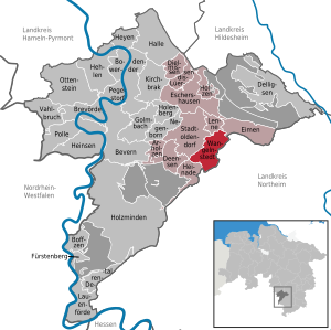
| Location of the community Wangelnstedt in the district of Holzminden | ||
  |
||

Wangelnstedt is a municipality in the Holzminden district in Lower Saxony ( Germany ) and is part of the Eschershausen-Stadtoldendorf municipality .
geography
location
Wangelnstedt is not far north of the Solling . The community is located east of the city of Stadtoldendorf between the mountain ranges of Elfas in the northeast, Amtsberge in the south, the Holzberg in the southwest and the Homburgwald in the northwest. The upper reaches of the Lenne flow through the community.
Community structure
In addition to Wangelnstedt, the community also includes the districts of Denkiehausen , Emmerborn and Linnenkamp .
Neighboring communities
In the southwest, Wangelnstedt borders on Heinade , in the west on Stadtoldendorf , in the north on Lenne and Eimen and in the east and south on the city of Dassel ( district of Northeim ).
history
Wangelnstedt was first mentioned in a document as Villa Wanhelist in 1251 in connection with a foundation of Heinrich von Luthardessen (Lüthorst) with the consent of the Abbot von Corvey to the Amelungsborn monastery (document book for Westphalia). The village came from Homburg ownership in 1495 to the Principality of Braunschweig-Wolfenbüttel , where it was administered from the Homburg Office. At the time of the Soest feud it was destroyed and lay desolate for several decades. Under Heinrich II , it was rebuilt as a parish village in 1518.
From 1807 to 1813 Wangelnstedt with around 330 inhabitants belonged to the Kingdom of Westphalia and therein to the department of the Leine , district of Einbeck , canton of Stadtoldendorf . Then Wangelnstedt came to the Duchy of Braunschweig . The community has been part of the Holzminden district since 1832 .
Incorporations

On November 20, 1972, the communities Wangelnstedt, Linnenkamp, Emmerborn and Denkiehausen decided to merge on January 1, 1973 under the community name Wangelnstedt.
politics
Municipal council
After the local elections on September 11, 2016 , the municipal council consists of:
- Voting Community Wangelnstedt (WGW): 4 seats
- Independent group of voters Wangelnstedt (UWW): 4 seats
- Free Democratic Party (FDP): 1 seat
mayor
Marcel Lohmann (WGW) has been mayor since 2016. He replaced Manfred Adam (WGW), who had been mayor since 1981.
coat of arms
The coat of arms symbolizes the Mönchsklause on a red background, which existed near Wangelnstedt until the early 17th century, and the Lenne in the lower part against a green background.
economy
The GFR Society for the preparation and recovery of residual materials mbH, a joint venture between Knauf Gips in Iphofen and GP Günter Papenburg AG, has been operating a branch in the former gypsum mine since 1989 and a landfill between Wangelnstedt and Lüthorst for low-pollutant ashes and residues from flue gas desulfurization of coal-fired coal Industrial power plants. In August 2017, an extension of the landfill was approved until 2032.
In Emmerborn there has been the Brockenblick residential park campsite since 1973.
traffic
The Lower Saxony state road 546, which connects Stadtoldendorf with Einbeck, runs through the municipality of Wangelnstedt.
The European cycle route R1 leads directly through the village.
religion
In Wangelnstedt there is the Johanniskirche of the Evangelical Lutheran parish Wangelnstedt, built between 1905 and 1907, and a chapel in the Linnenkamp district.
Individual evidence
- ↑ State Office for Statistics Lower Saxony, LSN-Online regional database, Table 12411: Update of the population, as of December 31, 2019 ( help ).
- ↑ H. Th. Wenner: Westphalian document book. Volume 4, Part 3, 1973, p. 294
- ^ Federal Statistical Office (ed.): Historical municipality directory for the Federal Republic of Germany. Name, border and key number changes in municipalities, counties and administrative districts from May 27, 1970 to December 31, 1982 . W. Kohlhammer GmbH, Stuttgart / Mainz 1983, ISBN 3-17-003263-1 , p. 211 .
- ↑ Election results of the 2016 local elections
- ↑ Member communities of the integrated community Eschershausen-Stadtoldendorf
literature
- Wolfgang Anders: The history of the community Wangelnstedt and its districts, 2004
- Dietrich Adam: On the village history of Wangelnstedt, shown in the development of a farm since the middle of the 18th century, 1966
Web links
Arholzen | Bevern | Bodenwerder | Boffzen | Brevörde | Deensen | Delligsen | Derental | Dielmissen | Buckets | Eschershausen | Fürstenberg | Golmbach | Hall | Caves | Heinade | Heinsen | Heyen | Holenberg | Wood | Holzminden | Kirchbrak | Lauenförde | Lenne | Lüerdissen | Negenborn | Ottenstein | Pegestorf | Pollen | Stadtoldendorf | Vahlbruch | Wangelnstedt
Unregulated areas in the district of Holzminden
Boffzen |
Buckets |
Eschershausen |
Green plan |
Holzminden |
Merxhausen |
Wenzen