
Delligsen
| coat of arms | Germany map | |
|---|---|---|

|
Coordinates: 51 ° 57 ' N , 9 ° 48' E |
|
| Basic data | ||
| State : | Lower Saxony | |
| County : | Holzminden | |
| Height : | 191 m above sea level NHN | |
| Area : | 36.01 km 2 | |
| Residents: | 7762 (Dec. 31, 2019) | |
| Population density : | 216 inhabitants per km 2 | |
| Postal code : | 31073 | |
| Primaries : | 05187, 05181 | |
| License plate : | HOL | |
| Community key : | 03 2 55 008 | |
| Community structure: | 6 districts | |
| Address of the municipal administration: |
Schulstr. 2 31073 Delligsen |
|
| Website : | ||
| Mayor : | Stephan Willudda ( independent ) | |
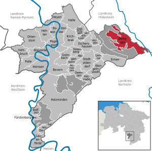
| Location of the community Delligsen in the district of Holzminden | ||
  |
||

Delligsen is a unified municipality and a patch in the district of Holzminden in Lower Saxony (Germany). Delligsen is a member of the Leinebergland region .
geography
location
Delligsen is located in the Leinebergland between the mountain ranges Reuberg in the north, Steinberg in the northeast, Selter in the southeast, Hils in the south and west and Ith in the northwest. The Wispe flows through the village as a southwest tributary of the Leine .

Community structure
According to Section 1 (2) of the main statutes, the Delligsen area is divided into the following six localities:
| Locality | Population (2013) | Remarks |
|---|---|---|
| Wet nurses | 393 | southern district and 185–205 m above sea level. NHN |
| Delligsen | 3676 | 191 m above sea level NHN and seat of the unified municipality |
| Green plan | 2421 | northwestern district, 172–250 m above sea level. NHN and state-approved resort |
| Hohenbüchen | 421 | northernmost district, 162–205 m above sea level. NHN and near the Reuberg |
| Kaierde | 889 | southwestern district and 150–175 m above sea level. NHN |
| Varrigsen | 264 | southeastern district and 140-170 m above sea level. NHN |
| Spots Delligsen | 8064 |
The highest point in the Hils is 480.4 m above sea level. NHN high altitude Bare cell .
Neighboring communities
Starting in the south-east and clockwise, the town of Einbeck ( Northeim district ), the community-free areas of Wenzen and Grünenplan (Holzminden district) and the district of Coppengrave des Fleckens Duingen ( joint municipality of Leinebergland ), the town of Alfeld and the municipality of Freden (all districts ) border the spots Delligsen Hildesheim ).
history
Delligsen was mentioned several times as Disaldishusen as early as 850 in the archives in the Corvey Monastery , which acquired property in the neighborhood in Kaierde and Gerzen.
In the year 1007 the Eringaburg south of Delligsen was mentioned in a border description commissioned by Bishop Bernward from the Diocese of Hildesheim , but the archaeological finds point to a much earlier settlement. The noble family, enfeoffed by Corvey in 1140, was named as Lords of Delligsen and named themselves Hohenbüchen after their nearby castle in the 13th century . In 1355 the rule passed to the noblemen of Homburg and from 1409 to the Guelphs .
In 1691 the industrialization of the place began very early with the construction of a paper mill and from 1735 the ducal Carlshütte, which used the hydropower of the Wispe River and the wood from the Hils to smelt the iron ore there . On May 24, 1736, the Friedrich-Carls-Hütte zu Delligsen was founded for ore mining and as an ironworks. In 1744 the settlement of Grünenplan emerged from high and late medieval traveling glassworks above the village, a stationary glassworks that still exists today, further industrial and commercial branches shaped the Hilsdörfer united in the patch. The parish village of Delligsen has been mentioned as a patch since 1807, and in 1771 it was given a market privilege for two annual general and livestock markets because of its economic importance, which had grown through early industrialization. 1871 Change of name to Eisenwerke Carlshütte AG , in 1895 the smelting and in 1896 the iron ore mining was stopped, and the operation was limited to a pure foundry operation. In February 1901, the bank went bankrupt due to floods. Continued operation as Braunschweigisch-Hannoversche Maschinenfabrik AG . After the merger with the Bernburger Maschinenfabrik , the Carlshütte continued to operate under this name. In 1917 the company name was changed to Maschinen- und Fahrzeugfabriken Alfeld / Delligsen . In 1930 the company went bankrupt again.
From 1933 the Carlshütte was put back into operation as the Alfeld machine and apparatus construction company. In 1938 the August Engels iron foundry in Velbert took over the ironworks and in 1944 had over 1200 employees. The graves of Soviet forced laborers who perished during the Nazi era are located in the Delligser Friedhof . Around 1,500 Russians, Ukrainians, Poles, Italians and French who had to work for the armaments company August Engels GmbH were housed in several camps. A labor education camp (AEL) that was affiliated with the company was also located on the factory premises . A memorial stone in the same cemetery commemorates the Jews from Delligs who were murdered in concentration camps .
From April 1955 a social reorganization took place and the Carlshütte was spun off from the Velberter August-Engels works and continued to operate under the name Eisen-, Stahl- und Armaturenwerk Friedrich-Carl-Hütte Delligsen . In 1984, as FCH-Friedrich-Carl-Hütte GmbH Stahlgießerei , the hut went bankrupt again with 700 employees. A state guarantee of 500,000 DM for the temporary continuation of production by the state credit committee of the state of Lower Saxony was rejected.
In December 1996, 9,375 people lived in the Delligsen area. On November 1st, 2008, there was a fire with several detonations in the production hall of Chemex GmbH, a supplier for the foundry industry in Delligsen and a subsidiary of Hüttenes-Albertus (HA). The building burned to the ground and there was damage to property amounting to millions. In the nearby Wispe stream, contaminated fire fighting water caused fish to die. Until the end of 2010, the village of Grünenplan was a state-approved resort .
For the development of the postal system in Delligsen, see: Braunschweig-Göttingen postal route .
Place names
Old names of Delligsen are from 826–876 Dysieldeshusun, 826–876 Diseldashusen, 826–876 Disaldeshusen, 1016–1020 Dysileshusun, 1140 Dislessem, 1146 Diselisseim, 1182 Diseldeshem, 1183 Disildesheim and 1188 Diselesheim. In view of the initially clear evidence of "‑husen" and their predominantly Hildesheim tradition from the 12th and early 13th centuries, it is assumed that education is based on the basic word "-husen". The determiner contains a two-part personal name. According to the oldest evidence, a "Dis (i) forest" can be assumed. The second element of the personal name belongs to the personal name stem "wald, waldan" for "rule". The interpretation of the first element of the personal name is more problematic. Some researchers use a personal name stem “disja”, which is said to belong to a Germanic adjective “des” (“clever, wise”) derived from “(filu-) deisei” (“cleverness”).
Incorporations
On March 1, 1974, the communities Ammensen and Varrigsen were incorporated into the spots Delligsen. On the same day, he and the Kaierde community moved from the Gandersheim district to the Holzminden district. On April 1, 1974, the communities Grünenplan, Hohenbüchen and Kaierde were added. Before that, Ammensen, Delligsen, Kaierde and Varrigsen belonged to the dissolved Gandersheim district and were incorporated into the Greene District Court. Hohenbüchen and Grünenplan were in the Eschershausen office, which was subordinate to the Holzminden district. Before 1946, both districts were part of the Free State of Braunschweig , as well as the Duchy of Braunschweig-Lüneburg Wolfenbüttelschen part in the Principality of Braunschweig-Lüneburg .
Population development
|
|
¹ as of December 31st

|
Religion / belief


- The Evangelical Lutheran St. George's Church on the corner of Rotestraße and Hilsstraße in Delligsen belongs to the Gandersheim-Seesen Provostry . The parish also has a kindergarten in Delligsen. There are other Evangelical Lutheran churches in Ammensen, Grünenplan, Hohenbüchen, Varrigsen and Kaierde.
- The Catholic St. Joseph Church, located between Schulstrasse and Untere Winkelstrasse, was built in 1958 by Josef Fehlig and named after Josef von Nazaret . Since 2006 the church belongs to the parish of St. Marien in Alfeld.
- The New Apostolic Congregation Delligsen was founded in 1929, after which New Apostolic divine service had been held in an inn since 1927. From 1932 on, the community used a former sheepfold on Hilsstrasse. Construction of the church on Hainbruchstrasse began in 1982, and it was consecrated in 1983. In 2005 the community was dissolved and the church was converted into a residential building. Today the nearest New Apostolic Church is in Alfeld, 8 km away.
- The assembly of Jehovah's Witnesses in Delligsen was given up in 2007 and joined the community in Alfeld.
- The Humanist Association Delligsen / Grünenplan is an association for non-religious residents.
politics
Municipal council
The municipality of the Fleckens Delligsen has consisted of 20 councilors and councilors since the local elections in 2016. This is the specified number for a municipality with a population between 7001 and 8000 inhabitants. In the 2011 election, 22 council members had to be elected. The council members are elected for a five-year term by local elections. The current term of office began on November 1, 2016 and ends on October 31, 2021.
The full-time mayor is also entitled to vote in the council of the municipality.
Since the local election on September 11, 2016, the municipal council has been composed as follows:
| SPD : | 11 seats |
| CDU : | 5 seats |
| UWG : | 3 seats |
| FDP : | 1 seat |
mayor
The full-time mayor of Delligsen is Stephan Willudda ( non-party ). His deputies are Rita Nienstedt (SPD), Hans-Werner Raabe (independent) and Sabine Tippelt (SPD).
Chronicle of the mayor
- 2019 – date: Stephan Willudda (independent)
- 2011–2019: Dirk Knackstedt (SPD)
- 2003–2011: Hans-Dieter Krösche (SPD)
- 1996-2001: Erwin Mittendorf (SPD)
- 1983: Günter Otte
Chronicle of the community directors
- 1991–2003: Wolfgang Becker
coat of arms
Municipal coat of arms
|
|
Blazon : "The coat of arms of the municipality shows four quarters :
|
Justification for the coat of arms: The municipality of Delligsen mentions this on its website:
|
Coat of arms village Delligsen
 |
Blazon : “In gold a blue tip , in it a golden crowned golden lion; in front the black crowned blue letter C , behind a blue mallet and a blue iron in diagonal crossing. " |
Justification for the coat of arms: Klemens Stadler says in his book:
|
Town twinning
-
 Grodzisk Wielkopolski , Poland , partnership since 2001
 -
 Merksplas , Belgium , partnership since 2011
 -
 Gatersleben , Saxony-Anhalt ( Germany ), friendly relations since 1990


Culture and sights
Museums
- Erich Mäder Glass Museum in Grünenplan
- Glassmaker's house in Grünenplan
- Delligsen local history museum in Delligsen
- Kaierde village room in Kaierde
Fortifications
- Eringa-Burg ramparts in Ammensen
- Pronounced wall trench system in Delligsen
- Düsterntal Castle , today Delligsen Castle
societies
There are around 25 clubs in Delligsen, including sports and motor sports clubs, dance and swimming clubs, music and singing clubs, shooting and riding clubs, interest groups and an allotment gardening club.
Regular events
- The village of Delligsen celebrates the four-day “Delligser Heimatfest” every four years with numerous parades and a large marquee on the hard court on Maschstrasse, most recently in May 2016.
Economy and Infrastructure
education
There is a primary school each in Delligsen and Grünenplan. In Delligsen there is also a secondary school based on the open all-day school model . in the school network with the Duingen community . The closest high school is in Alfeld .
traffic
Landesstraße 589 (Hilsstraße) connects Grünenplan and Delligsen with Bundesstraße 3 .
For decades, the Voldagsen-Duingen-Delligsen small railway provided the connection to rail traffic . However, general traffic on this route was discontinued in 1967 and the route was dismantled by 1968.
Personalities
Sons and Daughters of the Spot
Delligsen:
- Friedrich Wilhelm Meves (1814–1891), pharmacist, zoologist, ornithologist, curator at the Swedish Naturhistoriska riksmuseet from 1842 to 1877
- August Allruth (1873–1922), forest worker and politician ( USPD ) and member of the Braunschweig Parliament from March to May 1920
- Gerhard Bremer (1917–1989), officer of the Waffen-SS and holder of the Knight's Cross of the Iron Cross
- Reinhard Kammerer (* 1951), Lieutenant General of the Bundeswehr and Deputy Inspector of the Army
Grünenplan district:
- Heinrich Tønnies (1825–1903), photographer
- Ferdinand Koch (1832–1904), hut owner and member of the Reichstag ( National Liberal Party )
- Ludwig Pahl (1872–1948), forest worker, politician ( USPD ) and member of the Braunschweig Parliament 1920–1922
- Konrad Peek (1881–1926), businessman, politician ( SPD ) and member of the Braunschweig Parliament from 1924–1926
- Mike Rose (1932–2006), painter and writer
- Sabine Tippelt (* 1961), dental assistant, politician ( SPD ) and member of the Lower Saxony state parliament since 2008
District Ammensen:
- Karl Keunecke (1888–1957), worker, politician ( SPD ) and member of the appointed Braunschweig Landtag in 1946
- Werner von Seelen (* 1936), Professor of Neuroinformatics and Theoretical Biology
People connected to the stain
- Friedrich Carl Ludwig Koch (1799–1852), entrepreneur
- August Merges (1870–1945), politician and revolutionary
- Heinz Hohmeister (1940–2017), roofer and church man
Trivia
In 2008 Delligsen hit the headlines of the press. According to research by the Association of Taxpayers , the municipality spent 165,219 euros on the creation of a village chronicle for the 1150th anniversary of the town in 2000. Despite the enormous investment, it has not yet been published (2012). The only reference work is the local history from 1950.
literature
- Hugo Busch: From table makers and bird dealers. Green plan / Alfeld 1993.
- A. Reuter: 1100 years of Delligsen. History of the Hilsmulde and the place Delligsen. 1950.
Web links
- Web site of Patch Delligsen
- Mining history in the Leinebergland: iron ore mining and smelting of the Carlshütte in Delligsen (PDF; 1 MB)
Individual evidence
- ↑ State Office for Statistics Lower Saxony, LSN-Online regional database, Table 12411: Update of the population, as of December 31, 2019 ( help ).
- ↑ Thomas Krueger: We are not Jews, are we? Jewish life and its end in Delligsen, an industrial area in southern Lower Saxony. In: Arnd Reitemeier, Uwe Ohainski (Hrsg.): From the south of the north . 2013, ISBN 978-3-89534-988-1 , pp. 306 .
- ↑ Damage worth millions due to fire in Delligsen. In: ad-hoc-news.de. November 13, 2008, archived from the original on November 13, 2008 ; accessed on January 19, 2020 .
- ^ Jürgen Udolph (research): The "place name researcher". In: website NDR 1 Lower Saxony . Archived from the original on January 26, 2016 ; accessed on January 19, 2020 .
- ↑ a b Federal Statistical Office (ed.): Historical municipality register for the Federal Republic of Germany. Name, border and key number changes in municipalities, counties and administrative districts from May 27, 1970 to December 31, 1982 . W. Kohlhammer, Stuttgart / Mainz 1983, ISBN 3-17-003263-1 , p. 212 .
- ^ Ulrich Schubert: Community directory Germany 1900 - Gandersheim district. Information from December 1, 1910. In: gemeindeververzeichnis.de. January 5, 2020, accessed January 19, 2020 .
- ^ A b c Michael Rademacher: German administrative history from the unification of the empire in 1871 to the reunification in 1990. Landkreis Gandersheim ( see under: No. 20 ). (Online material for the dissertation, Osnabrück 2006).
- ↑ a b Statistisches Bundesamt Wiesbaden (ed.): Official municipality register for the Federal Republic of Germany - 1957 edition (population and territorial status September 25, 1956, for Saarland December 31, 1956) . W. Kohlhammer, Stuttgart 1958, p. 205 ( digitized version ).
- ↑ Lower Saxony State Administration Office (ed.): Municipal directory for Lower Saxony . Municipalities and municipality-free areas. Self-published, Hanover January 1, 1973, p. 56 , Gandersheim district ( digitized [PDF; 21.3 MB ; accessed on January 19, 2020]).
- ↑ a b c d e f g h i j community directory - archive - regional structure - annual editions - Lower Saxony. (All politically independent municipalities in EXCEL format). In: Destatis website. Federal Statistical Office, accessed on January 19, 2020 .
- ↑ a b Council of Fleckens Delligsen. In: Website Flecken Delligsen. Retrieved January 19, 2020 .
- ^ Lower Saxony Municipal Constitutional Law (NKomVG); Section 46 - Number of Deputies. In: Lower Saxony Regulations Information System (NI-VORIS). December 17, 2010, accessed January 19, 2020 .
- ↑ Main statutes of the patch Delligsen. (PDF; 98 kB) § 2; Coat of arms, official seal; Paragraph 1. In: Flecken Delligsen website. November 17, 2016, p. 1 , accessed January 18, 2020 .
- ↑ a b Description of the coat of arms. In: Website Flecken Delligsen. Retrieved January 18, 2020 .
- ↑ a b Klemens Stadler: German coat of arms of the Federal Republic of Germany . The municipal coats of arms of the federal states of Lower Saxony and Schleswig-Holstein. tape 5 . Angelsachsen-Verlag, Bremen 1970, p. 33 .
- ↑ 36. Black Book of the Association of Taxpayers - Public Waste 2008. (PDF; 3.7 MB) In : steuerzahler.de. September 2008, p. 49 , archived from the original on December 28, 2015 ; Retrieved on January 19, 2020 (expensive image maintenance - tax-financed advertising and image polishing. p. 50).
Wet nurses | Delligsen | Green plan | Hohenbüchen | Kaierde | Varrigsen
Arholzen | Bevern | Bodenwerder | Boffzen | Brevörde | Deensen | Delligsen | Derental | Dielmissen | Buckets | Eschershausen | Fürstenberg | Golmbach | Hall | Caves | Heinade | Heinsen | Heyen | Holenberg | Wood | Holzminden | Kirchbrak | Lauenförde | Lenne | Lüerdissen | Negenborn | Ottenstein | Pegestorf | Pollen | Stadtoldendorf | Vahlbruch | Wangelnstedt
Unregulated areas in the district of Holzminden
Boffzen |
Buckets |
Eschershausen |
Green plan |
Holzminden |
Merxhausen |
Wenzen