
Duingen
| coat of arms | Germany map | |
|---|---|---|

|
Coordinates: 52 ° 0 ' N , 9 ° 42' E |
|
| Basic data | ||
| State : | Lower Saxony | |
| County : | Hildesheim | |
| Joint municipality : | Leinebergland | |
| Height : | 212 m above sea level NHN | |
| Area : | 59.62 km 2 | |
| Residents: | 4892 (Dec. 31, 2019) | |
| Population density : | 82 inhabitants per km 2 | |
| Postal code : | 31089 | |
| Area code : | 05185 | |
| License plate : | HI, ALF | |
| Community key : | 03 2 54 041 | |
| LOCODE : | DE NXN | |
| Community structure: | 7 districts | |
| Address of the municipal administration: |
Töpferstrasse 9 31089 Duingen |
|
| Website : | ||
| Mayor : | Klaus Krumfuß ( CDU ) | |
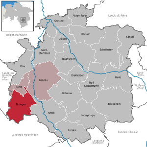
| Location of the municipality of Duingen in the Hildesheim district | ||
  |
||

Duingen (high German pronunciation by typeface [dʊɪŋən] dialektal (Eastphalian) Daujen [daʊʒən]) is a patch in the integrated municipality Leinebergland in the Lower Saxony Hildesheim . It is a member of the Leinebergland region , a voluntary association of various cities and municipalities in southern Lower Saxony founded according to the Leader approach .
geography
location

Duingen is located a little east of the Weserbergland Schaumburg-Hameln Nature Park in the Leinebergland between Ith , Thüster Berg and Duinger Berg . The source of the south-western Leine tributary Saale is close by . Several hiking and cycling trails lead through the Duinger Forest to the idyllic Duinger Lake District with the Bruchsee , Humboldtsee , Ententeich and Weinbergersee lakes .
Community structure
The municipality of Duingen consists of the following districts:
- Capellenhagen (residents: 141)
- Coppengrave (population: 624)
- Duingen-Kernort (population: 2706)
- Fölziehausen (pop .: 84)
- Hoyershausen with Lübbrechtsen and Rott (population: 439)
- Marienhagen (pop .: 750)
- Weenzen (pop .: 362)
(Population figures as of November 30, 2016)
history
Duingen was first mentioned in writing between 826 and 876 as Duthungun . The place name is a formation with the suffix -ung or -unga to a basic word * duð / þ- of unknown meaning (perhaps a plant name). Historical variants of the place name are u. a. Dudingen, Tuingoburg, Dujen.
In April 948 the Duke of Saxony and King of Eastern Franconia, the later Roman-German Emperor Otto I, stayed in Duingen.
Around 1233 the "Knights of Duingen" lived in the so-called "Tinne". The "Tinne" is in Alfelder Weg and is Duingen's oldest house. In 1642 the shepherd's house at Hirtenweg 1 was built. At that time Duingen had around 800 inhabitants. The first windmill was built in 1661 on the Windmühlenweg. In 1742 the windmill was dilapidated and rebuilt. The master miller Großmann was active until the end of the 1960s. The mill was later converted into a residential building. In 1911 the Duingen volunteer fire brigade was founded. In 1977 Duingen came to the district of Holzminden and was reclassified to the district of Hildesheim in 1981.
Incorporations
As part of the regional reform in Lower Saxony , which took place on March 1, 1974, the previously independent municipalities of Capellenhagen and Fölziehausen were incorporated into the municipality of Duingen.
On November 1, 2016, the municipalities of Coppengrave , Hoyershausen , Marienhagen and Weenzen were incorporated. At the same time, the Duingen joint municipality was merged to form the new Leinebergland joint municipality . Duingen is no longer the administrative seat, but has branches of the new joint municipality.
Population development
|
|
¹ as of December 31st

|
religion

- The Evangelical Lutheran Katharinenkirche , built 1735–1739 according to plans by Ernst Braun , is located at the rectory. The parish, whose rectory is also looked after by the parish of Coppengrave and the chapel parish of Ith-Weenzer-Bruch, belongs to the Hildesheimer Land / Alfeld parish .
- The Catholic Church Guter Hirt was built in 1960/61 on Ebertstrasse. It has been part of the parish of St. Marien in Alfeld since 2006 .
- There is a New Apostolic Church on Töpferstrasse on the outskirts. The parish was founded in 1930, and its first church building was consecrated in 1953. The community belonged to the Hildesheim church district and was closed in 2014.
politics
Municipal council
The municipal council from Duingen consists of 4 councilors and 13 councilors from the following parties:
(Status: local election September 11, 2016)
mayor
The mayor of Duingen is Klaus Krumfuß (CDU). His deputies are Andrea Prell (SPD) and Wolfgang Schulz (WGL).
coat of arms
The community Duingen was the municipal coat of arms on August 22, 1939 by the Provincial President of the Province of Hanover awarded. The district administrator from Alfeld presented it on December 9th of the same year.
|
|
Blazon : “In a blue shield on a green three-mountain seated a silver dove with gold reinforcement ; above in the left corner of the shield a silver heraldic rose with golden sepals and stamens . " |
| Justification of the coat of arms: The coat of arms is derived from a stain seal that has been documented for Duingen since the 17th century and which points to the place name (Duwe-nigen / Duwe = dove). The old seal has often changed; once the pigeon is directed to the left, then again to the right. In its beak it carries a rice that is sometimes interpreted as a palm frond, then again as an olive branch. Later, a heraldic rose was added to the coat of arms as a symbol. At first it was found above the shield, later in the shield above the pigeon's back. Whether this symbol was borrowed from the coat of arms of the noble family "von Duingen" can be assumed; for this led three roses in a golden shield. The latest stipulated patch coat of arms is based on the traditional, but with a different tinging and with the addition of the three-song and the omission of the rice in the pigeon's beak. |
Coat of arms of the incorporated localities


Culture and sights
- Duinger Seenplatte (Bruchsee, Humboldtsee, Weinbergersee) about four kilometers from the village
- Pottery Museum Duingen
Economy and Infrastructure
In the community there are kindergartens, a high school, a primary school as well as two supermarkets, a drinks market and an indoor swimming pool.
traffic

- Duingen is on the B 240 federal highway .
- The railway connection used to be in the form of the Voldagsen-Duingen-Delligsen small railway . In the meantime, the line is no longer in operation, but the Kleinbahn VDD association is aiming for museum traffic in the direction of Voldagsen.
- Duingen is connected to Alfeld and Thüste via bus route 64 operated by Regionalverkehr Hildesheim GmbH .
- Hiking and cycling trails lead to the Duinger Lake District, among other places.
literature
- Ralf Busch : Duingen: a pottery town in Lower Saxony. Exhibition catalog. Publications of the Braunschweigisches Landesmuseum 2. Braunschweig 1975.
- Ralf Busch: Medieval and modern pottery between Alfeld and Deister. In: Guide to Prehistoric and Protohistoric Monuments. Volume 48: Hanover, Nienburg, Hildesheim, Alfeld. Part I: Introductory Essays. Verlag Philipp von Zabern, Mainz 1981. pp. 224-231. With references.
- Historical Museum am Hohen Ufer Hannover . In cooperation with Westermann's. Hanover 1986. p. 113: Illustration "Braunes Duinger Steinzeug".
- Ulrich Fliess: Folklore Department. Exhibition catalog of the Historisches Museum am Hohen Ufer Hanover II. Hanover 1972. pp. 95–98: Duinger Steinzeug (historical overview) and exhibits in wall showcase 141 (corresponding images in plate 14).
Web links
Individual evidence
- ↑ State Office for Statistics Lower Saxony, LSN-Online regional database, Table 12411: Update of the population, as of December 31, 2019 ( help ).
- ↑ Friedrich Becker: Datt Dausche Platt . In: Duinger Heimat- und Kulturverein e. V. (Ed.): Series of publications by the Heimat- und Kulturverein . tape 16 , 2016, p. 12 .
- ↑ Population figures in the Leinebergland community. (PDF; 4 kB) In: Website Vennekohl. November 30, 2016. Retrieved September 20, 2017 .
- ↑ Dr. Paul Wigand (Ed.): Traditiones Corbeienses . FA Brockhaus, Leipzig 1843, § 352, p. 77 (in the margin: Dudingen).
- ↑ Harald Bichlmeier: Etymological Dictionary of Old High German . Ed .: Rosemarie Lühr. V: iba - luzillo. Vandenhoeck & Ruprecht Verlag, Göttingen 2014, ISBN 978-3-525-20771-0 (lemmas: -ing / -ung, -inga / -unga).
- ↑ Guus Kroonen: Etymological Dictionary of Proto-Germanic . In: Alexander Lubotsky (Ed.): Leiden Indo-European Etymological Dictionary Series . tape II . Brill, Leiden / Boston 2013, ISBN 978-90-04-18340-7 , pp. 106 (Lemma: * dudra / on-).
- ^ Gerhard Köbler: Old English dictionary. Letter D. 2014, accessed on March 28, 2017 (Lemma: dȳþ).
- ^ Society for older German history (ed.): Momunenta Germaniae Historica . tape 1 . Impensis Bibliopolii Hahniani, 1879, p. 181 .
- ^ Federal Statistical Office (ed.): Historical municipality directory for the Federal Republic of Germany. Name, border and key number changes in municipalities, counties and administrative districts from May 27, 1970 to December 31, 1982 . W. Kohlhammer, Stuttgart / Mainz 1983, ISBN 3-17-003263-1 , p. 204 .
- ↑ Law on the unification of the communities of Banteln, Betheln, Brüggen, Despetal, Rheden and the city of Gronau (Leine) as well as on the new formation of the Duingen area and the Leinebergland community, district of Hildesheim . In: Niedersächsische Staatskanzlei (Ed.): Niedersächsisches Gesetz- und Verordnungsblatt (Nds. GVBl.) . No. 22/2015 . Hanover December 15, 2015, p. 399–400 , pp. 17–18 ( digital copy [PDF; 278 kB ; accessed on June 29, 2019]).
- ^ A b c d Michael Rademacher: German administrative history from the unification of the empire in 1871 to the reunification in 1990. Alfeld district ( see under: No. 14 ). (Online material for the dissertation, Osnabrück 2006).
- ^ Ulrich Schubert: Register of local authorities in Germany 1900 - Alfeld district. Information from December 1, 1910. In: gemeindeververzeichnis.de. January 5, 2020, accessed July 6, 2020 .
- ↑ a b Statistisches Bundesamt Wiesbaden (ed.): Official municipality register for the Federal Republic of Germany - 1957 edition (population and territorial status September 25, 1956, for Saarland December 31, 1956) . W. Kohlhammer, Stuttgart 1958, p. 172 ( digitized version ).
- ↑ Lower Saxony State Administration Office (ed.): Municipal directory for Lower Saxony . Municipalities and municipality-free areas. Self-published, Hanover January 1, 1973, p. 28 , Alfeld district ( digitized [PDF; 21.3 MB ; accessed on December 27, 2019]).
- ↑ a b c d e f g h i j k Community directory - archive - regional structure - annual editions - Lower Saxony. (All politically independent municipalities in EXCEL format). In: Destatis website. Federal Statistical Office, accessed on December 27, 2019 .
- ↑ a b Duingen City Council. In: Website Samtgemeinde Gronau (Leine). Retrieved July 3, 2017 .
- ^ A b Wilhelm Barner : Coat of arms and seal of the Alfeld district . Rebinding. Lax GmbH & Co. KG, Hildesheim 1998 ( digitized version of the text part of the first edition from 1940 [PDF; 10.0 MB ; accessed on June 10, 2019]).
- ↑ Duingen Pottery Museum. In: Website Samtgemeinde Leinebergland. Retrieved July 25, 2018 .
Alfeld (Leine) | Algermissen | Bad Salzdetfurth | Bockenem | Diekholzen | Duingen | Eime | Elze | Freden (leash) | Giesen | Gronau (Leine) | Harsum | Hildesheim | Holle | Lamspringe | Nordstemmen | Sarstedt | Ringed | Sibbesse | Söhlde
Capellenhagen | Coppengrave | Duingen | Fölziehausen | Hoyershausen (with Lübbrechtsen and Rott ) | Marienhagen | Weenzen