
Sarstedt
| coat of arms | Germany map | |
|---|---|---|

|
Coordinates: 52 ° 14 ' N , 9 ° 52' E |
|
| Basic data | ||
| State : | Lower Saxony | |
| County : | Hildesheim | |
| Height : | 64 m above sea level NHN | |
| Area : | 42.94 km 2 | |
| Residents: | 19,391 (Dec. 31, 2019) | |
| Population density : | 452 inhabitants per km 2 | |
| Postal code : | 31157 | |
| Area code : | 05066 | |
| License plate : | HI, ALF | |
| Community key : | 03 2 54 028 | |
| LOCODE : | DE SAT | |
| City structure: | 7 localities | |
City administration address : |
Steinstrasse 22 31157 Sarstedt |
|
| Website : | ||
| Mayoress : | Heike Brennecke ( SPD ) | |
| Location of the city of Sarstedt in the Hildesheim district | ||
  |
||

Sarstedt ( lat. Kertzstadensis ; nds. Sassti'e ) is a small town located on the Innerste River in (south) eastern Lower Saxony (West- Ostfalen ). The middle center of the Hildesheim district has not quite 20,000 inhabitants .
geography
Sarstedt is located about 13 km northwest of Hildesheim and 21 km southeast of Hanover. Sarstedt was the only one between 1885 and 1946 and has been the northernmost town in the Hildesheim district ever since. To the west of the village runs the Innerste , which is fed by the Bruchgraben in the south and flows into the Leine 2 km further in the northern district of Ruthe . The Leinebergland ends with the Sarstedt-Sehnder mountain range and finally merges into the north German lowlands. Sarstedt borders in the east on Algermissen , in the south-east on Harsum , in the south on Giesen and Barnten (which has been part of Nordstemmen since 1974 ) (all district of Hildesheim ), in the north-west on Pattensen and in the north on Laatzen (both Hanover region ).
Since the territorial reform of 1974, in addition to the core city, Sarstedt has also had six localities, each with their own mayors:
- Poisons : 759 inhabitants
- Gödringen : 576 inhabitants
- Heisede : 1091 inhabitants
- Hotteln : 580 inhabitants
- Ruthe : 323 inhabitants
- Schliekum : 618 inhabitants
The population in the core city is 15,635 and including the six localities 19,582 inhabitants (as of December 31, 2019)
history
Surname
The changing name of the city of Sarstedt was already noticed by Jacob Grimm , who saw the numerous variants of the city name as conspicuous. For the co-author of the lexicographers German dictionary , the numerous variations of the name were due to the peculiarity of Low German ; because also in other Low German place names with the initial letter K replaced by different sibilants over the centuries ( assibilization ) and thus the wealth of variants has been increased. The "Hildesheim town of Sarstedt" stood out for him in a special way from this group of place names:
“Still other Low German place names with their changing S SC CH TZ SZ Z point to the original K; so the little town of Sarstedt in Hildesheim, which in chronicon at Pertz 9, 861–865 Scherstede Tzerstede Cherstede Chyerstede, in documents from 1252. 1349 at Lüntzel s. 110. 222 Destede Zchiarstede Cserstede Tzerstide Tzarstede and named after a glossator of the Sachsenspiegel Brand von Tzerstedt; I suspect it was initially Carastad locus [...] "
The origin and origin of the name of the city of Sarstedt is described even more succinctly in the city's history by Hans Wehling. In 1973 he wrote:
“In the time between 300 and 800 AD, the places with the current ending -stedt were created. Sarstedt is one of them. Presumably, the places were created through the expansion of the settlement area, even in Old Saxon times, i.e. before the invasion of the Franks. If you go back to the first written forms of this name, you can infer its meaning. If you put the spelling Stardethe, Cerstede or Tzerstede in relation to the old German word scard means swamp, the name can be interpreted as a settlement on the swamp. From the ending 'stede', derived from the even older 'ithi', one can derive settlement: 'stard ithi'. The results of place name research are indicative of the approximate age. If you consider the location of the first settlement on the northern edge of the large swamp area, which was formed by the Bruchgraben and Innerste, the name interpretation is absolutely correct. The field name 'Altes Dorf', south of Hildesheimer Straße, still indicates the first settlement today. "
Wehling gives further variants of the Sarstedt place name: "Destede (1221), Schirstede (1225–1247), Tzerstede (1302), Cerstede (1367), Tzerstede (1434) and Cerstidde (1474)".
Over the course of time, Sarstedt had different, hardly believable, different ways of writing. In over 10 centuries, documents and archives of the city have repeatedly been lost or destroyed and fired. This is an explanation why different spellings of the city name have accumulated in shorter periods of time.
Prehistory and prehistory
Since numerous brickworks were in operation in and around Sarstedt for a long time, fossils have repeatedly been discovered in the clay pits required for this. In the clay pit Moorberg , nanoplankton, lobster-like crustaceans with the Latin name Hoploparia dentata , and sea sponges (achilleum morchella) from the planer limestone found in Sarstedt, which comes from the Lower Cretaceous , a geological age that dates back 130-134 million years, were found. In the area of today's Sarstedt there was a sea at that time, which only withdrew to the north millions of years later. The ancestors of humans, such as the Neanderthals and Homo erectus , could also be detected in the Sarstedt district. Since these archaeological finds, Sarstedt has been the “northernmost point in Europe, where the remains of this human line of development that died out 30,000 years ago were discovered”.
The first permanent settlements in the area in and around Sarstedt are known to have taken place around 7,000 years ago. For the Neolithic Age , band ceramics and thus a phase of peasant cultures without metal processing has been archaeologically proven for Sarstedt as well as in the neighboring communities of Barnten , Jeinsen and Algermissen .
middle Ages

Between 772 and 802, today's Sarstedt area was in the catchment area of the Franks' 30-year campaigns under Charlemagne against the then pagan Saxons (between the North Sea and Harz , Rhine and Elbe ). In 2001, before a business park was established in Heisede , graves of old Saxon horsemen and horses were found in a rescue excavation. They date from the 8th century and were found on a parcel that has been called "Heidenkirchhof" since ancient times. The finds show striking parallels with those finds that are attributed to those involved in the Battle of the Süntel (782). During the emergency excavation on the other side of the federal highway 6 at the level of the northern feeder of the B6 between Heisede and Sarstedt-Nord, Christian (i.e. Frankish-Carolingian) graves without gifts were also found.
Since the beginning of the 9th century is north of Sarstedt (before Heisede there is the street name as an extension to the eastern Heath Cemetery), the deserted village of Help Earth (alt. Helperdun ) mentioned in documents (826-876), in addition to the Diocese of Hildesheim , the Michaeliskloster the Counts of Wunstorf and the Corvey Monastery owned lands here. A noble family that can be traced back to the 12th century came from the place. The desert must have existed as a place until 1458, because Sibert von Bolzum, among other things, “received the court over the place and the clearing tithe from the Hildesheim bishop”.
The role that Sarstedt played in the Hildesheim diocese in the 9th and 10th centuries is not clear from the archaeological and traditional written sources. But there will have already been a ford at the innermost part and a market town. The old Sarstedt settlement core will initially have developed in the area of the "Old Village" (1279 Altendorp ) as the property of the Hildesheim Cathedral Chapter , that is the eastern part of the city above the not far from the old mill (today Mühle Malzfeldt), the mouth of the Bruchgraben in the Innerste between Festplatz and Hildesheimer Strasse.
One of the earliest written sources that point to the Sarstedt area is a source from the year 993. That was at a time when Bernward was loyal and respected by him even before he took office as Bishop in Hildesheim (January 993) Teacher of King Otto III. had elegantly resolved a dispute about the penal limit. He convened a commission to establish the boundary between the Minden monastery and Hildesheim , which left the Leine (near Sarstedt) below Hanover. This commission for the regulation of the monastery border was high-ranking. In addition to the bishops Erp von Verden , Dodo von Münster , Friedrich zu Mainz and secular commissaries, there are also 16 sworn witnesses from the immediate vicinity, including two brothers from Wennerde from the Ostfalen with the names "Thiedhard" and "Oddo de Wongerdun" (Wennerde (lat. Wongerdun (990), later Wengarde (around 1038), was a deserted area west of Sarstedt, beyond the present-day station building on the way to Schliekum , which rose in Sarstedt with the granting of town charter in the early 14th century). A certain “Deddi de Rothun” also appeared as a witness, obviously a man from the Ruthe district, who also appears in Latin in the Latin source.
Around the year 1000 had the northern today part of Sarstedt, Ruthe, at the mouth of heart and leash already a fortified protection system and formed as a possession of the Bishop of Hildesheim the northwestern border town of Gau Astfala . As a church settlement and therefore also a mission point, Sarstedt ( Kertzstadensis ) is mentioned for the first time in 1075 and in comparison with the older mission base in Elze . Sarstedt lies on an old trade route , the Hellweg in front of Santforde , which in the Middle Ages connected the dioceses of Minden and Hildesheim .
From 1150 to 1450, the Hildesheim monastery was the area in the north German lowlands in which one did not have to bow to the Brunswick family of the Guelphs, since the "feudal sovereignty of the Hildesheim bishop (...) did not allow separate counties". Since 1200 the city of Sarstedt will have spread between the church, presumably located near St. Nicolai, and the bishop's castle. The location of the original castle is presumed to be on the area that today delimits the lower Steinstraße, the Burgstraße, the Weichsstraße and the Innerste (today the area of the indoor and swimming pool with parking lot). Because this area is only a few steps away from the Innerstebrücke and the western city gate (wooden gate). The Bischofs- or Retburg (later also Rietburg or Rittburg owned by von Alten) had the task from the beginning to protect the episcopal Hildesheimer Land against the Guelphs in the west, the Leine crossing at Ruthe and the Innerstefurt at Sarstedt. The episcopal court was first mentioned in a document under Hildesheim Bishop Siegfried I in his last year in office, 1221 (i.e. before the city was actually founded). Originally built Hoftyp frühkarolingischer time is also Villikation called. A manor or Fronhof (Latin curtis ) with extensive, self-cultivated land (Salland, Latin terra salica ) was allegedly operated here, and around this Fronhof grouped smaller farms (Hufen, Latin mansi ), which were given by the landlord and were worked by the farmers.
The court of the Bishop of Hildesheim must have been leased as a fiefdom before 1221, as the owners at that time, the brothers Basil and Lippold von Escherde, exercised bishopric ministerial rights (on behalf of the Hildesheim bishop) in Sarstedt. It was Bishop Konrad II , who, as it were, as a lessor in succession to Siegfried I (until 1221), had the tower built by these bailiffs in this place torn down between 1222 and 1225 ( villa Schirstede , 1225-1247). Apparently they had acted without the bishop's consent and built this tower, or else the new bishop wanted them to feel his power. Two decades later, under the same bishop Konrad II. Bodo von Gleidingen is mentioned as an appointed bailiff of this castle ( in castro Chyarstede ) at the innermost part. Duke Albrecht von Braunschweig captured the castle in 1256 and burned it down around 1279 during Otto I's reign. In a contract dated December 10, 1283, it was therefore possible to speak of a “Sarstedt Castle to be built by the bishop”. In 1485 the castle and city of Sarstedt were destroyed again in the bishop's battles against the city of Hildesheim. This is why the Retburg is also associated with the Weichsschen Hof (1724–1752), the rudiments of which, including the two-part Hermitage on Steinstrasse, only gave way to newer projects at the beginning of the 1970s and whose reconstruction has been under discussion for several years.
_IMG_1434.JPG)

The oldest settlement core of the village is presumably in the area of the Evangelical Lutheran Church of St. Nicolai (the previous building was donated between 1038 and 1044 and provided with a tithe as a source of income, which was previously granted to the church in Elze), which is located on a hill located above the "old village" and the nearby junction of the Bruchgraben with the Innerste as well as southwest of the mill, which is first mentioned in 1302 and since the early 14th century belonged to the table goods (Mensal- or later Kammergut ) of the bishop in Hildesheim. The current construction of St. Nicolai dates back to 1457. It has not been proven that Sarstedt had previously been donated a stone church by Thietmar , the successor of the canonized Hildesheim Bishop Godehard , in his tenure (1038-1044). In any case, the first mill in front of St. Nicolai was built in the place where the Innerste had previously formed a river island and therefore offered ideal conditions for a naturally protected mill operation.
Sarstedt was the object of arguing political forces early on. In the middle of the 13th century (1254) the Asseburg was besieged by Albrecht the Great for three years in vain from the Duchy of Braunschweig-Lüneburg . Gunzelin's eldest son Burchard (Busso), who called himself " von der Asseburg ", had stubbornly defended her. The Hildesheim bishop Heinrich viewed the impending transition of the little land to the Welfenhaus as his own affair and took sides with Asseburg. In 1255 the feud broke out openly, the result of which was that Albrecht was able to conquer the towns of Sarstedt and Rethen in 1256 in addition to the opposing fortress Wolfenbüttel, Asseburg and, a year later, in the prince-bishopric of Hildesheim and in the Hildesheimer Stift .
Sarstedt became a town around 1296, when Sarstedt was expanded territorially by Bishop Siegfried II (1279–1310); because after the inclusion of the older villages or settlements "Wennerde und Helperde", the city rights came into force. Presumably went with the prosperous material importance of Sarstedt since the 12./13. In the 19th century, the increased structural efforts to secure the city went hand in hand, especially the construction of the city wall, rampart and moat as well as the construction of the two city gates "Ostertor" (in the east) and "Holztor" (in the west in front of the Innerste Bridge).
Sarstedt was first mentioned as a town in a document in a list with other localities such as Braunschweig , Goslar or Hildesheim in 1339 (January 31). A people's priest or pastor (lat. Plebanus ) is documented for 1250 , in 1258 a Sarstedt citizen is named in a document. From 1319 Sarstedt is referred to as civitas , 1327 the place is guaranteed as archdeacon seat, and from 1428 the first seal of the city dates back to. The city was repeatedly destroyed and had to be laboriously rebuilt: first in 1283, after the great feud in 1485, the Hildesheim monastery feud in 1521, 1556, 1580, 1716 and 1798.
In the middle of the 14th century, however, the place Sarstedt must have made a very consistent and loyal impression for the leadership of the Sarstedt clergy, as the clergy in Hildesheim had come into conflict with the city. The council and the cathedral chapter faced each other in a hostile manner, and consideration was given to moving the residence to Goslar or Sarstedt because there was fear of violence by the Hildesheim citizens. In addition, in 1374 Charles IV had allowed the Hildesheim bishop to “set up a free-lance chair”. In 1395, the episcopal geographer “ auf dem Hassel ” decided civil disputes within the citizenship.
Early modern times and Reformation


In the 13th and 14th centuries, Sarstedt experienced a largely peaceful time under the rulers of Hildesheim, the prince-bishops of the monastery. The customs station established under Bishop Magnus in Sarstedt, however, represented a turning point. This customs station caused displeasure, as the Hildesheim monastery had been exempt from customs duties for a long time. The Hildesheim episcopal chronicle counts five arsonings or natural fires alone for the period of 168 years (from 1412 to 1580), which have thrown Sarstedt back in its development (January 29, 1412: fire to the ground with many deaths; September 23, 1485: Great feud in which Sarstedt was completely destroyed with fireballs ; 1522: Hildesheim feud in which people from Braunschweig and Hanover plundered the city and burned down numerous houses; 1556: Burned down the whole city after the harvest on Wednesday after Michaelis; and from September 8, 1580, the bishop's chronicle reports: Sarstedt was burned from the ground up for the fifth time, that nothing but the church and the Frisian and Barner courts remained standing. The last great fire, which in 1716 almost again took place in the entire city of Sarstedt laid the ashes, not to lie here).
.png&filetimestamp=20150828212950&)
| year | Residents |
|---|---|
| 1593 | 131 |
| 1654 | 1.012 |
| 1785 | 1,134
(el:?; rk:?; j :?) |
| 1786 | ?
(el:?; rk:?; j: 3 families) |
| 1833 | 1,223
(el:?; rk:?; j: 36) |
| 1848 | 1,469
(el:?; rk:?; j: 36) |
| 1855 | 1,579 |
| 1861 | 1,701
(el:?; rk:?; j: 82) |
| 1862 | 1,520 |
| 1864 | ?
(el:?; rk:?; j: 85) |
| 1865 | 1,694
(el:?; rk:?; j: 85 (1864)) |
| 1867 | 1,695 |
| 1871 | 1,753
(el:?; rk:?; j: 71) |
| 1885 | 2,455 (el:?; Rk:?; J: 54) |
| 1890 | 2,768
(el: 2.173; rk: 595; j: 34) |
| 1895 | 3,195
(el:?; rk:?; j: 43) |
| 1900 | 3,664 |
| 1903 | 3,664 |
| 1904 | 3,932 |
| 1905 | 4.147
(el:?; rk:?; j: 21) |
| 1910 | 4,645
(el: 3.522; rk: 1.093; j: 30) |
| 1916 | 4,373 |
| 1917 | 4,550 |
| 1919 | 4,803 |
| 1925a | 5,002 (March 1);
(el:?; rk:?; j: 18) |
| 1925b | 5,093
(el:?; rk:?; j: 18) |
| 1925c | 5,106 (June 16) |
| 1927 | 5,169 |
| 1928 | 5,260 (Dec. 31) |
| 1930 | 5,292 |
| 1933a | 5,472 |
| 1933b (June) | 5,415
(el:?; rk:?; j: 10) |
| 1936 | 5,710 |
| 1938a | 5,806 (Jan 1) |
| 1938b | approx. 6,000 (Dec. 31) |
| 1939 (May) | 5,744
(el:?; rk:?; j: 5 + 121) |
| 1945 | 8,500 |
| 1949 | 9,797 (Oct 1) |
| 1961 | 10.196 |
| 1970 | 13,420 |
| 1972 | 13,500 |
| 1999 | 17,805 |
| 2010 | 18,551 |
| 2014 | 18,626 |
| 2018 | 19,478 |

In the middle of the 14th century, residents of the Jewish faith were recorded for Sarstedt for the first time. (Numbers of Jewish residents, see bottom left: Table 1).
On August 4, 1503, the newly elected bishop and sovereign, Johann IV of Hildesheim from Sarstedt, made his entry into Hildesheim. But in his time the Hildesheim collegiate feud broke out (1519). Sarstedt went up in flames one more time. At first it seemed that John IV would win after the Battle of Soltau (1519). The fact that a military success is not as important as a political one can also be seen in the fact that after the Quedlinburg Recess, despite its military defeat , the "great pen" was placed in the care of the Duke of Calenberg, Erich I. von Calenberg-Göttingen on 13. May 1523 came. Hildesheim had to give up its possessions of Gronau, Wohldenstein and Sarstedt. Still defeated in the Battle of Soltau, Erich I succeeded in triumphing through an arbitration award from Emperor Charles V , adding the larger parts of the bishopric to his rule. Sarstedt was subordinate to welfisch and the Coldingen office (OT von Pattensen , 13 km from Sarstedt).
Three years before Luther's death in 1546, the Reformation entered Sarstedt at the turn of the year 1542/43. In 1542 a Calenberg church order for the whole of Calenberg-Göttingen, commissioned by the sovereign Elisabeth and developed by Corvinus (also known as Elisabeth's church order ) , was written and, after the thorough church visit (November 17, 1542 to April 30, 1543), to Elisabeth personally participated, decreed. A monastery order of November 4, 1542 regulated the Protestant reorganization of the monasteries . In 1544 an additional court order was issued to regulate the legal situation in the country. To underpin her determination, the princess wrote numerous sacred songs with her own hands as well as a letter to her subjects , which was supposed to strengthen them in their faith.
During the turmoil of the Thirty Years' War , the various combatants increasingly clashed at Sarstedt: On October 12, 1625, a Danish colonel and his Protestant troops asked for provisions. Three days later the enemy generalissimo who had set up his headquarters in Mahlerten in order to defeat Calenberg Castle. Seven years later, for the relief (a military operation) of the tax forest, the cavalry of General Lintlo crossed the line near Poppenburg , but was defeated by the Lüneburg troops under the leadership of Duke Georg near Sarstedt. Nine years later, on July 9, 1634, imperial Catholic troops met the siege army to defend Hildesheim "am Hülpersberge" near Sarstedt (today "am Kipphut") and were defeated by them. In the evening the winners stood again in front of Hildesheim, which they had previously besieged for a long time. When the French and Swedes fought on German soil for 13 years (1635–1648), the Swedes temporarily set up camp at the confluence of the Innerste with the Leine (in the Sarstedt district of Ruthe ) seven years later (September 1641). The Swedes and the Lüneburg troops camped at Sarstedt under the "Hülpersberge", the opponents at Groß Lafferde . In 1673 Sarstedt was once again the place of negotiation for commanders in command of opposing troops. Towards the end of the 16th century, 131 citizens (including nine protected warriors and three saddle farms) were counted in Sarstedt (1593).
1653-1815 the place was again part of the diocese of Hildesheim, before the city came together with the diocese to the Kingdom of Hanover .
During the 18th century, von Sarstedt became known that nobles from Friesland and Mecklenburg had their own properties here. In the largest encyclopedia of that time, it is said that “some of the nobility, such as the Frisians and Barners ”, had “freye castle courtyards” here.
Until it was connected to the modern mass transport system of the railway in the middle of the 19th century, Sarstedt's location on a river crossing that can be crossed by customs and bridges is of great importance in reference works.
Recent history
During the time of the French occupation (1807 and 1813) Sarstedt belonged to the department of the Oker (with the capital Braunschweig ) as part of the Kingdom of Westphalia , which was established after the Peace of Tilsit (July 7th and 9th, 1807). King was Jérôme Bonaparte , a brother of Napoleon Bonaparte . From the department of the Oker three cantons came from the previous district of Hildesheim , Elze (the part on the left bank of the Leine), Sarstedt and Algermissen , to the department of the Aller (from September 1, 1810).
From 1815 to 1866 Sarstedt belonged to the Kingdom of Hanover , from 1866 to the Prussian Province of Hanover. Around 1850, Sarstedt was a town in the Ruthe district of the Principality of Hildesheim (excluding the mill and Mühlenstrasse, which were administered by Calenberg), including the courts of Gogericht, city court and regional court. Sarstedt achieved the status of a titular town in 1852 and thus a certain official independence; jurisdiction was not passed from the Ruthe office to the Hildesheim district court until 1859. At that time flax (for the production of linen) was mainly grown in the area around the city , which was the only textile fiber next to hemp, nettle and wool from the Middle Ages until the 19th century.
Sarstedt had a train station as early as the middle of the 19th century, a stop on the Hanover Southern Railway , the Hanover-Alfeld section of which was opened in 1853. In 1890 Sarstedt had 2,768 inhabitants, including - as it was called in the Brockhaus at the time - "561 Catholics and 34 Israelites".
Latest history and contemporary history


Agriculture and small businesses shaped Sarstedt for most of the 19th century. Sarstedt became a titular town in 1852 , and in 1929 it received the official town status in accordance with the Prussian municipal ordinance valid at the time.
After the construction of the Hanover-Hildesheim rail link with a Sarstedt stop and the Sarstedt train station, a soap and light factory was built. In addition, the bishop's mill was taken over by the merchant Ernst Malzfeldt in 1854, who was able to expand the business with his sons to become the first commercial milling company in Lower Saxony thanks to the new means of transport. A locksmith's shop from 1844 formed the basis for an oven and stove factory in the 1870s, later Vosswerke AG, whose workforce increased tenfold from 100 employees in 1880–1914 in barely 35 years. The Vosswerke operated their own track systems in order to be able to transport their heavy goods better. Two match factories were also established in Sarstedt between 1850 and 1900.
After the First World War, there was also a sugar factory in Sarstedt, but it did not last long. Starting in 1800, six brickworks were built in Sarstedt until 1850, of which the Dachsteinfabrik Otto Gott GmbH still exists today. The city's transfers are quantified as follows: “In 1996 there were a total of 700 companies with 6,000 employees in Sarstedt. 2,500 people commuted to work in the town, 4,100 went to work in Hanover or Hildesheim ”(Jürgen Rund).
From the middle of the 19th century to the First World War , the Sarstedt population quadrupled (from around 1,500 to 5,700); after the Second World War it had doubled again. On the one hand, this influx was associated with industrialization and the associated economic prosperity. Although a small town in the Prussian province, Sarstedt was able to participate in the industrial development through the railway connection early on. On the other hand, both world wars resulted in a population shift through migration and displacement, which brought Sarstedt a significant increase in its population.
The willingness to invest, which was encouraged by the rail connection, inevitably led to an increase in the population, and this to an expansion of the city area. During this time, the city experienced a significant expansion of the building mass beyond the Innerste to the southern Giebelstieg district. At the end of the 1880s, the Holztorviertel, which was built at the end of the 1880s, prospered, not least because of the new attraction established by the train station as a traffic junction. New building activity in the western part of the city on Holztorstraße and on the so-called Füllkuhle (Venice, Schliekumerstraße, Querstraße) was particularly brisk at the time. Until the turn of the century, the area bounded by Giesener Strasse, the Vosswerke and the train station was built on.
To the south of Vosswerke AG, apartments for private use were built from 1898 onwards by the “non-profit building association”. In 1938, 20 homes were built on the Dehnberg, and around 1,200 new apartments were added in the 1950s. Further settlements emerged in the 1960s and 70s on the areas previously used for agriculture.
Facets of this turbulent but also eventful time in the Lower Saxony city can be found in the Sarstedt police reports from a hundred years (1853-1947), of which the most interesting excerpts were printed in 1996 in the “Sarstedter Anzeiger”. This chronicle, which is accessible in its parts, gives a deep historical insight into the consequences of two world wars for a city in the catchment area of Hanover and in the district of Hildesheim.
At the beginning of the 20th century, Sarstedt in the Hildesheim district belonged to the Kingdom of Prussia in the German Empire. Contemporary reference works considered the telegraph office, the sugar, stove and match factory, the iron foundry, five steam brick factories and two steam mills to be worth mentioning.
Potash mining has played an important role in economic life in the Sarstedt district since the beginning of the 20th century, where potash salts were mined underground to produce fertilizer. Both potash chutes " Glückauf-Sarstedt " and " Siegfried-Giesen ", which belong directly to Sarstedt , had a mine connection railway and served numerous Sarstedt families for several generations as a source of income from 1904/06 until they were both closed in 1987. If a revitalization of "Siegfried-Giesen" has been considered since the end of 2010 and a feasibility study is commissioned from a fertilizer and salt manufacturer, this would be the first time after the Second World War that "a disused mine is put back into operation" . Among the Sarstedt potash buddies there were quite a few refugees and displaced persons from the eastern regions , with the 1960s the immigration of so-called guest workers began, among whom quite a few found a second or a new home in Sarstedt.
Incorporations
On March 1, 1974, the communities of Giften, Gödringen, Heisede, Hotteln, Ruthe and Schliekum (the latter from the Springe district ) were incorporated.
religion


The late Gothic building of the St. Nicolai Church, until the Reformation church of the Archdeaconate Sarstedt in the diocese of Hildesheim , was completed in 1457 and replaced a Romanesque previous building from the 11th century. It is named after St. Nicholas as the patron saint of merchants. In 1543 the Lutheran church order was introduced for the church and town .
The Roman Catholic Heilig-Geist-Kirche was built in 1912/13 in the neo-Romanesque style and was subordinate to Ruthe until 1961. The Catholics in Sarstedt were referred to the parish in Ruthe, and from the middle of the 18th century they were able to use the private chapel of the Weichsschen Hof for worship. It was not until 2002 that it underwent a thorough interior renovation with postmodern design elements.
As the second Lutheran church in Sarstedt, St. Paulus Church was built in 1963–1965 in the Giebelstieg district. Constructed with a reinforced concrete skeleton and faced with light clinker bricks, it is built in the style of a basilica . The slightly advanced tower is crowned with an Annunciation angel and measures 37 m high. To the northeast of the city center is the youngest Evangelical Lutheran church in Sarstedt, the Paul Gerhardt Church.
A New Apostolic Church is located on the southern outskirts of Sarstedt (In der Peulen 21). The community belongs to the church district Hannover-Südwest.
politics
City council
The council of the city of Sarstedt consists of 32 council women and councilors. This is the specified number for a municipality with a population between 15,001 and 20,000. The 32 council members are elected for five years each by local elections.
The full-time mayor Heike Brennecke (SPD) is also entitled to vote in the city council.
The 2016 local elections resulted in the following:
- SPD: 14 seats
- CDU: 8 seats
- GREEN: 3 seats
- FDP: 3 seats
- Wahl-Alternative-Sarstedt: 3 seats
- Independent: 1 seat
mayor
Heike Brennecke (SPD) is the full-time mayor of the city of Sarstedt. In the last mayoral election on September 28, 2014, she was elected with 53.0% of the vote. The turnout was 42.9%. Brennecke took up office on November 1, 2014, replacing the previous incumbent Karl-Heinz Wondratschek (SPD), who had no longer run.
coat of arms
Blazon : “Split of gold and red, covered with a green shamrock on a twisted stem.” When Bishop Siegfried II of Hildesheim raised Sarstedt to town in 1296, the first seal appeared at the same time, which was one over waves that stand for the innermost three-tower castle pictured shows. On the battlements of the lower central tower a saint appears growing in the 15th century with a cross staff and a book. By Otto Hupp , he is called the Saint Anthony described. From the 17th century, the coat of arms developed independently of the earlier seal and has been in its current form since then. The split shield stands for the coat of arms of the Hildesheim Monastery, the clover leaf probably goes back to a former place symbol.
Town twinning
Sarstedt has had town twinning with the French communities of Aubevoye and Gaillon since 1992 and with the Brandenburg community of Ahrensfelde since 2018 .
Culture and sights
Sarstedt in literature
- In his novella " Die Innerste ", the Lower Saxon writer Wilhelm Raabe drew a loving picture of the landscape on the Innerste bank south of Sarstedt and thus upstream.
- Günter Grass became internationally known with his early works “ Tin Drum ” (1960), “ Cat and Mouse ” (1961) and “ Dog Years ” (1963). In 1999 he received the Nobel Prize for Literature because - as the Nobel Prize Committee noted - "he drew the forgotten face of history in lively black fables". In the last novel of his Danzig trilogy , Sarstedt also became the setting for one of his fictional rooms. Sarstedt is mentioned a total of five times in “Dog Years” - exclusively in connection with a potash plant that is “between Hildesheim and Sarstedt”. In the same year that "Dog Years" was published, "Spiegel" said that Grass had drawn a realistic picture "between Hildesheim and Sarstedt" for his "Fantasy Mine". He described the "mine operation" that is common here "technically exact", which also had a biographical background. Because after his release from American captivity, Grass initially worked as a paddock boy in the Groß-Giesen potash mine (Siegfried plant) in the southern Giesen part of Sarstedt in 1947. There he was responsible for the in and out of the mining lorries, i.e. their coupling. To refresh his memories for his work, Grass drove into a nurses' den again in 1962. In a television interview in May 1984, Grass called his “Dog Years” - compared to the “Tin Drum” - the more important book.
Theaters and museums


The Malzfeldt watermill , located directly on the Innerste, was first mentioned in 1302 and lost its purpose in 1965 because it has been used as a hydroelectric power station since then. The electricity generated in this way is fed into the public grid. There is also a mill museum in the power plant and can be visited by prior arrangement. The Sarstedt cultural center is located in the “Haus am Junkernhof”, where events on music, literature and (performing and visual) art as well as the city and regional history take place. In addition, a local museum will be housed in the “Haus am Junkernhof”, in which a historical pharmacy and a rope maker can be seen as a permanent exhibition. There are also special exhibitions.

Buildings
- The Gödring memorial near Thieplatz commemorates those who fell in the war.
- A bronze plaque on the half-timbered house at Steinstrasse 13, a former business building of a Jewish fellow citizen, commemorates the families living in Sarstedt. Today the municipal meeting place is housed here.
- The Catholic Holy Spirit Church with its 32 meter high bell tower was built in 1913.
- The Protestant St. Nicolai Church with a 41 meter high bell tower was built as a Gothic quarry stone building in its current form in 1457.
- The water mill and hydroelectric power station Malzfeldt an der Innerste from the 14th century are now a listed building. The grain mill was shut down in 1965 and its water power was converted to generate electricity. Today there is a mill museum in the building.
- In 1866 a trade school was founded for the Sarstedt tradespeople as a Sunday school. The building, built in 1861, is located at Steinstrasse 8 near the Innerstebrücke.
- The town hall in the form it still exists today was built in 1799 on the foundation walls of the previous building that burned down in 1798. A representative feature of the building is the large double-sided staircase. The place in front of the town hall was given the name Aubevoye-Gaillon-Platz and thus dedicated to the French twin town.
- The Ratsapotheke from 1787 is Sarstedt's oldest pharmacy. In the meantime, the building was used as a mail carrier from 1847 to 1853 and as a registry office from 1874 to 1881.
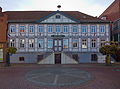
Town hall from 1799

Brick extension from 1882 on the town hall

Ratsapotheke in Steinstrasse
Trade school from 1861


Green spaces and recreation
The Innerstebad Sarstedt is an indoor and leisure pool, the outdoor pool is open in the summer season from May to September. The Gifteen lakes and the bathing lake in the Heisede district are also ideal for local recreation .
Economy and Infrastructure
Company (selection)
- Kelvion PHE (formerly GEA Ecoflex GmbH ) - manufacturer of plate heat exchangers
- Avacon Natur GmbH - subsidiary of Avacon, a regional supply company , which in turn is a subsidiary of E.ON AG .
- Helmke, manufacturer of electric motors
- Wiedemann , wholesaler for building technology
- CPR GmbH , manufacturer of condoms and the machines and laboratory equipment necessary for condom production (according to its own statement, the largest condom manufacturer in Europe)
- Herbert Kannegiesser GmbH with the Kannegiesser Passat division - manufacturer of industrial laundry technology , in Sarstedt: manufacture of cycle washing machines
- Smurfit Kappa Wellpappe Sarstedt (production site) - formerly Winner Wellpappe
media
- Sarstedter Zeitung (founded October 13, 1888 to June 1, 1941), discontinued by order of the Reich Propaganda Minister Joseph Goebbels.
- Sarstedter Anzeiger
- Kleeblatt.net : Local newspaper on Thursday for the Sarstedt, Hildesheim North and Hanover South region
Public facilities
- Innerstebad - indoor and leisure pool of the city of Sarstedt
- Sarstedt city library
- Sarstedt local history museum
- Klecks youth center
- City archive Sarstedt
- Voluntary agency spontaneously (in cooperation with the neighborhood help of the Evangelical Lutheran Church District)
- With the GEO600 there is a detector for recording possible gravitational waves in Ruthe near Sarstedt. This is part of the international LIGO facility , which consists of five detectors.
education
- Albert Schweitzer School - Reliable elementary school and special school for learning assistance
- Kastanienhof primary school - Reliable primary school
- Rainbow School - Reliable elementary school
- Sarstedt high school
- Schiller High School Sarstedt with two locations
- Education and conference center of the AOK Lower Saxony


traffic

Local public transport, rail, tram and bus

.png&filetimestamp=20150828212950)
In 1925 Maria Papenberg, born in Sarstedt, founded Algermissen in Sarstedt the first cab company. At that time, their vehicle fleet consisted of a powerhouse (Ford T-Model) and a horse-drawn carriage. At the beginning of the Second World War, however, the car was confiscated for war purposes. Their descendants, today's Kindling family, have been running the cab company in Sarstedt since 1967, but since then as a taxi company.
Sarstedt is located on the Hanover Southern Railway Hanover - Göttingen . There are also connections via the Upper Harz to Halle (Saale) via the Lehrte – Nordstemmen railway . The Hanover main station can be reached with the Hanover S-Bahn . Since 1900 there has been a direct electric light rail or overland tram connection with Hanover, which since 1958 no longer continues to Hildesheim, but ends in a turning loop. Various bus lines take over the internal development and connections with Hildesheim, Elze , Nordstemmen and Rethen . The most important bus operator is Regionalverkehr Hildesheim GmbH.
Air traffic facilities

On the hill Kipphut there is a VOR for navigation of the aircraft . The instrument approach procedure for Hanover Airport begins here . If an approach is temporarily not possible, holding patterns will be flown here .
Road traffic
Sarstedt is on federal highway 6 .
Personalities
- Jean-Henri Pape (1789–1875), German-French piano maker
- C. Friedrich Heinrich Nötel (1830–1888), Protestant pastor and poet
- August Pape (1877–1922), manufacturer and member of the Lübeck citizenship
- Willy Tischbein (1871–1946), cyclist and industrialist
- Konrad Rakemann (1902–1964), German politician (SPD), MdL
- August Gabel (* 1908), German politician (CDU), MdL
- Waltraute Macke-Brüggemann (1913–2006), painter, graphic artist and book illustrator
- Dieter Stern (1934–2011), German chess player
- Walter Mahlendorf (* 1935), track and field athlete, 1960 Olympic champion in Rome
- Hans-Jürgen Krahl (1943–1970), protagonist of the 1968 and student movement , was born in the house at Voss-Straße 7 that is no longer there
- Francisca Tu (* 1943), German actress of Chinese origin, ran the hotel restaurant "Kipphut" in Sarstedt for many years.
- Rudolf Schenker (* 1948), co-founder of the hard rock formation Scorpions , originally from Sarstedt, planned a concert with the band in his old homeland in the 1990s (discarded because the city feared it would not be able to withstand the expected crowds)
- Harald Grosskopf (* 1949), musician, drummer for the Sarstedt beat band The Stuntmen from 1965 to 1966 , later co-founder of the “Berlin School” in Berlin around the electronics groups Ashra , Klaus Schulze and Tangerine Dream , was involved in over 100 LP / CD releases
- Marianne brook Meier (1950-1996), was known nationwide when she in a hall of the District Court Lübeck 1981 the alleged murderer of her daughter Anna Bach Meier in vigilantism had shot
- Eckhard Garve (1954–2020), German botanist and ornithologist
- Michael Schenker (* 1955), brother of Rudolf and like him a German hard rock guitarist ( Scorpions , UFO , Michael Schenker Group )
- Uwe Fröhlich (* 1960), President of the Federal Association of German Volksbanks and Raiffeisenbanks e. V. (BVR)
- Andreas Bovenschulte (* 1965), Mayor of Bremen, attended the Sarstedt high school
- Ulrike Hiller (* 1965), German politician (SPD)
literature
- Heiner Jürgens, Hans Lütgens, Arnold Nöldeke , Joachim Freiherr v. Welck: The art monuments of the Hildesheim district. Self-published by the Provincial Administration Theodor Schulzes Buchhandlung, Hanover 1938, pp. 176–189 (Sarstedt)
- Chronicle of the city of Sarstedt 1853 to 1949. Compiled on behalf of the city of Sarstedt by the editor of the “Sarstedter Kreisanzeiger” Albert Rolff, Sarstedt (around 1950) o. Year 187 p.
- Hans Wehling: Sarstedt - history of a small town . Edited and supplemented by Margarete Schaper, Verlag Kreis-Anzeiger, Sarstedt 1973
- Kurt Brüning , Heinrich Schmidt (ed.): Handbook of the historical sites of Germany . Volume 2: Lower Saxony and Bremen (= Kröner's pocket edition . Volume 272). 5th, improved edition. Kröner, Stuttgart 1986, ISBN 3-520-27205-9 .
- Jürgen Jacobi (Hrsg.): 200 years Rats-Apotheke zu Sarstedt. A short story of a small town pharmacy, self-published by the author, Sarstedt 1987
- Friedrich Dietrich (Ed.): Sarstedt. History of our city . Volume 1: From the ford to the place; The development; Historical; Reports about the city; Names, facts, history; 1853 to 1949. Yesterday and today; Pictures of the city, Sarstedt 2001. (Contains the long version of the chronicle of the city of Sarstedt from 1853 to 1949 , but also richly illustrated and with numerous essays by the city administrator Werner Vahlbruch and the city historian Hans Wehling)
- Margret Zimmermann, Hans Kensche: Castles and palaces in Hildesheimer Land . Published by Hildesheimer Volkshochschule e. V., Verlag Lax, Hildesheim 1998, ISBN 3-8269-6280-X .
- Andreas Voß: Dachsteinwerk Otto Gott, Sarstedt. In: Feldbahnmuseum Hildesheim (Hrsg.): Feldbahnkreuzt! , No. 9, October 2002, pp. 32-39
- Jürgen Rund: Urban Settlements. In: Carl-Hans Hauptmeyer, Jürgen Rund, Gerhard Streich (eds.): Journal Hanover (Hanover and Hanover-North). Historical and regional excursion map of Lower Saxony. Verlag für Regionalgeschichte , Bielefeld 2007, pp. 96–135, esp. 130–133
- Sarstedt under the swastika. The book for the series of the Sarstedter Anzeiger. With a foreword by Tarek Abu Ajamieh, Gebrüder Gerstenberg, Hildesheim 2008. ISBN 978-3-8067-8726-9
- Sarstedter Geschichtskreis, City of Sarstedt (Hrsg.): Sarstedt and the surrounding area on old postcards , Sarstedt 2014. 344 pages. (It contains historical postcards from the following locations: Giften, Gödringen, Heisede, Hotteln, Ruthe, Schliekum, Hannover, Hildesheim, Gleidingen, Rethen / Weetzen, Ingeln / Oesselse, Lühnde, Groß Lobke / Ummeln, Bledeln, Harsum, Algermissen, Asel , Uppener Pass, Himmelsthür / Müllingen, Klein Düngen / Groß Düngeln, Bad Salzdetfurth, Emmerke, Sorsum, Ahrbergen, Groß Förste, Giesen, Hasede, Barnten, Rössing, Jeinsen, Hüpede / Oerie, Pattensen, Thiedenwiese / Koldingen, Schulenburg, Springe, Eldagsen, Nordstemmen / Burgstemmen, Marienburg). ISBN 978-3-00-045557-5
- Jürgen Heise (ed.): Sarstedt from a bird's eye view. 45 new aerial photographs present the city from an unusual angle, Sarstedt 2008. ISBN 978-3-00-026247-0 (Volume 1: Heisede, Hotteln, Gödringen, Sonnenkamp, Kipphut, Bachstrasse, Lortzingstrasse, Loeweweg, Glückweg, Humperdinckstrasse, Schumannstrasse, Lortzingstrasse , Röntgenstrasse, Wellweg, Bachstrasse,…, Ruthe, Schliekum, Giftener Seen, Giften 48 pages); Volume 2: Heisede, Ruthe / Hopfenberg, Schliekum, Giften, Giebelstieg,…, Gödringen, Hotteln, Sarstedt 2013. also 48 pages, without own ISBN.
Web links
- Internet presence of the city of Sarstedt
- Excerpts from the police chronicle 1853 to 1949, Sarstedt no year, compiled by Uwe Kreibaum
Individual evidence
- ↑ State Office for Statistics Lower Saxony, LSN-Online regional database, Table 12411: Update of the population, as of December 31, 2019 ( help ).
-
↑ Sarstedt is referred to by this name in a Latin source from 1075, which describes the foundation of the Hildesheim church. The author was presumably Bernhard von Konstanz : Fundatio Ecclesie Hildensemensis. Hildesheim 1075.
(See also the bilingual edition by Adolf Bertram : Hildesheims Domgruft and the Fundatio Ecclesie Hildensemensis. A. Lax (Ed.) Hildesheim 1897, pp. 7–8 (Lat. And German as well as the digitized Latin edition in the Monumenta Germaniae Historica : p. 943 ).) - ↑ Advantic Systemhaus GmbH: City Sarstedt. Retrieved August 30, 2018 .
- ^ Heike Brennecke, Mayor: City of Sarstedt. In: City of Sarstedt. City of Sarstedt, March 31, 2018, accessed on May 10, 2018 .
- ↑ The passages cited by Grimm can be viewed today in Volume 7 of the scientific source edition Monumenta Germaniae Historica , which is published by the Bavarian State Library in Munich . dmgh.de , accessed on June 3, 2011.
- ^ Jacob Grimm: Keverlingeburg . In: M. Haupt (Hrsg.): Journal for German antiquity. Vol. 7, 1849, pp. 559-561. Digitized of the quoted passage in a later edition: Jacob Grimm: Kleinere Schriften , Vol. 7: Reviews and various essays. 4th part, Berlin 1884, p. 261 , accessed on June 3, 2011.
- ^ Hans Wehling: Sarstedt - history of a small town . Sarstedt 1973, p. 11.
- ↑ Angelika Köthe: Limy nannoplankton from the Unter-Hauterivium to Unter-Barremium of the clay pit Moorberg / Sarstedt (Unter-Kreide, NW Germany) . In: Messages from the Geological Institute of the University of Hanover , Issue 21, Hanover 1981.
- ↑ Werner Pockrandt: Hoploparia dentata (A. Roemer) from the Lower Cretaceous (Hautevirium) of Hanover and the surrounding area (Dekapoda). Systematics and found material (11th Fig.) . In: Arbeitskreis Paläontologie Hannover, 10th year, 2 (1982), pp. 1–12
- ^ Friedrich Adolph Römer: The petrifications of the north German chalk mountains , Hanover 1841, 2
- ↑ This is proven by the corresponding finds of bony skull remains and typical tool remains of three hominids (found in the Leinetal in November 1997 as well as in January and October 1999 in a Schliekum gravel pit by the Hanoverian hobby archaeologist Karl-Werner Frangenberg), the age of which was determined by the leading paleoanthropologist Alfred Czarnetzki (University of Tübingen) can now be estimated at 700,000 years.
- ^ Alfred Czarnetzki, S. Gaudzinski, A. Pusch: Hominid skull fragments from Late Pleistocene layers in Leine Valley (Sarstedt, District of Hildesheim). ( Memento of the original from July 25, 2014 in the Internet Archive ) Info: The archive link was inserted automatically and has not yet been checked. Please check the original and archive link according to the instructions and then remove this notice. (PDF; 393 kB) In: Journal of the Human Evolution. 41 (2001), pp. 133-140.
- ↑ Regional and national North German newspaper articles made this archaeological find public, including: Hinnerk Blombach: The Neanderthal lived near Hanover. In: Hamburger Abendblatt , March 14, 2003
- ↑ as well as: Tarek Abu Ajamieh: Are the finds older than expected? ( Memento of the original from July 25, 2014 in the Internet Archive ) Info: The archive link was inserted automatically and has not yet been checked. Please check the original and archive link according to the instructions and then remove this notice. (PDF; 291 kB) In: Hildesheimer Allgemeine Zeitung , July 19, 2008. Achim Duve: Neanderthal finds from the Leinetal near Sarstedt. In: Springer Yearbook 2011 for the city and the old district of Springe. Support association for the town history of Springe e. V., Springe 2011, pp. 23–25: Ill., Farbtaf. on pp. 212-213.
- ^ Hans-Günter Peters: Pre- and early history . In: Carl-Hans Hauptmeyer, Jürgen Rund, Gerhard Streich (eds.): Journal Hanover (Hanover and Hanover-North) . Historical and regional excursion map of Lower Saxony, Verlag für Regionalgeschichte, Bielefeld 2007, 24–34, esp. 27.
- ↑ "Wehmholz Route" hiking brochure (PDF)
- ↑ Erhard Cosack : The old Saxon "Heidenkirchhof" near Sarstedt, Ldkr. Hildesheim, and the battle at the Süntel 782 . Isensee Verlag, Oldenburg 2007, ISBN 978-3-89995-487-6 (= Studies on Saxony Research 16).
- ^ Uwe Ohainski: Medieval desolations . In: Carl-Hans Hauptmeyer, Jürgen Rund, Gerhard Streich (eds.): Journal Hanover (Hanover and Hanover-North) . Historical and regional excursion map of Lower Saxony, Verlag für Regionalgeschichte, Bielefeld 2007, 72–89, esp. 81
- ↑ “The Hildesheim bishop was known through the issue of fiefs for this area. In 1377 the Counts of Wunstorf transferred 3/4 of the tithe in the Oldendorper veld to the Hildesheim Moritzstift . Apparently the inhabitants left the place as early as the 14th century - allegedly because of a feud - and moved to Sarstedt. An equestrian grave and body graves from the Carolingian era have been excavated at the settlement site. ”Uwe Ohainski: Medieval desolations . In: Carl-Hans Hauptmeyer, Jürgen Rund, Gerhard Streich (eds.): Journal Hanover (Hanover and Hanover-North) . Historical and regional excursion map of Lower Saxony, Verlag für Regionalgeschichte, Bielefeld 2007, 72–89, esp. 77; on the equestrian grave uncovered in the mid-1920s, cf. Hans Gummel : The equestrian grave in Sarstedt, Hildesheim district , Hildesheim 1926.
- ↑ "At the site, structural remains of the site, including a medieval fountain, were discovered during an excavation in 1932." Cf. Uwe Ohainski: Mittelalterliche Wüstungen, in: Carl-Hans Hauptmeyer, Jürgen Rund, Gerhard Streich (eds.): Blatt Hannover ( Hanover and Hanover-North) . Historical and regional excursion map of Lower Saxony, Verlag für Regionalgeschichte, Bielefeld 2007, 72–89, esp. 86 and O. Grotefend: Wennerde - a medieval village near Sarstedt . In: Hannoversches Magazin 8 (1933), pp. 78-83.
- ^ Johann Heinrich Böttcher: History of the Kirchrode parish and the surrounding area , Hanover 1858, vol. 1, p. 38; Publications from the Prussian State Archives , Volume 65, Verlag S. Hirzel, 1896, p. 24; City archive and city library Hildesheim (ed.): Alt-Hildesheim , volumes 48–51, Verlag A. Lax, Hildesheim 1977, p. 18; Historical Association for Lower Saxony (Ed.): Hannoversche Geschichtsblätter (1978), p. 5.
- ^ Franz Anton Blum: History of the Principality of Hildesheim , Wolfenbüttel 1805, Vol. 2, P. 72ff. The Hildesheim District Home Federation also reminds of the strategic role of Sarstedt and Ruthe for the Hildesheim bishop . ( Memento of the original from April 2, 2012 in the Internet Archive ) Info: The archive link was inserted automatically and has not yet been checked. Please check the original and archive link according to the instructions and then remove this notice.
- ↑ (Cf. Fundatio Ecclesie Hildensemensis , Hildesheim 1075. (Printed in the bilingual edition by Adolf Bertram , Hildesheims Domgruft and the Fundatio Ecclesie Hildensemensis [...], Hildesheim 1897, p. 7 and 8 (lat. And German)): " [...] that highly respected church in Sarstedt ")
- ↑ Carl-Hans Hauptmeyer: General and Political History of the Middle Ages and the Modern Age . In: Carl-Hans Hauptmeyer, Jürgen Rund, Gerhard Streich (eds.): Journal Hanover (Hanover and Hanover-North) . Historical and regional excursion map of Lower Saxony, Verlag für Regionalgeschichte, Bielefeld 2007, 35–47, esp. 39.
- ↑ Hans Goetting: The Diocese of Hildesheim. The Hildesheim Bishops from 815 to 1221 (1227) , De Gruyter Verlag, Berlin, New York 1984, p. 522
- ↑ From this division into Fronhof and dependent hooves in the villication derives the designation two-part manorial rule: Georg Ludwig von Maurer : History of the Fronhöfe, the farms and the court constitution in Germany. 4 volumes. Enke Verlag, Erlangen 1862–1863 (reprint: Scientia, Aalen 1961) and Werner Rösener : article “Fronhof”. In: Lexicon of the Middle Ages . 8 vol., Stuttgart (1977) -1999, vol. 4, col. 989 f.
- ↑ a b Jürgen Rund: Urban settlements. In: Carl-Hans Hauptmeyer, Jürgen Rund, Gerhard Streich (eds.): Journal Hanover (Hanover and Hanover-North) . Historical and regional excursion map of Lower Saxony, Verlag für Regionalgeschichte, Bielefeld 2007, 96–135, esp. 131.
- ^ Margret Zimmermann, Hans Kensche: Castles and palaces in Hildesheimer Land . Published by the Hildesheimer Volkshochschule e. V., Verlag Lax, Hildesheim 1998, p. 142
- ↑ a b c d e f g Jürgen Rund: Urban settlements. In: Carl-Hans Hauptmeyer, Jürgen Rund, Gerhard Streich (eds.): Journal Hanover (Hanover and Hanover-North) . Historical and regional excursion map of Lower Saxony, Verlag für Regionalgeschichte, Bielefeld 2007, 96–135, esp. 132.
- ↑ From 1724 to 1752 Ignatz Freiherr von Weichs, Drost zu Steuerwald and his brother Adam, Canon zu Hildesheim, built their town house, the Weichsschen Hof, on the site of the old castle, to which the hermitage, which was demolished in the early 1970s, belonged. (See Margret Zimmermann, Hans Kensche: Burgen und Schlösser im Hildesheimer Land , Hildesheim 1998, p. 142). Further information on Retburg and the later Weichsschen Hof can be found in Hans Wehling: Sarstedt - Geschichte einer kleine Stadt , Sarstedt 1973, pp. 29–35, 65–66, Kurt Brüning, Heinrich Schmidt (eds.): Handbuch der Historische Stätze Deutschlands . Volume 2: Lower Saxony and Bremen , 5th edition, Stuttgart 1986, 411, Zimmermann, Kensche: Burgen und Schlösser […], p. 142.
- ↑ Hans Wehling: Sarstedt - history of a small town , Sarstedt 1973, pp. 35-38
- ↑ cf. also Ernst Schubert (ed.): History of Lower Saxony , Volume 2.1: Politics, Constitution, Economy from the 9th to the end of the 15th Century (= publications of the historical commission of Lower Saxony 36), Hanover 1997, p. 338.
- ↑ The income from the operation of this water mill went to the ecclesiastical sovereign, who also collected taxes in Sarstedt. Until the 19th century, because it was not located within the city wall, the mill was referred to as the "Mühle vor Sarstedt". Presumably it is also identical to the mill behind Ahrbergen , of which the episcopal files report, which is mentioned as the property of the Hildesheim bishop as early as the middle of the 13th century. Since the middle of the 19th century it has been called "Mühle Malzfeldt" after the new owner. In total, it had been in operation for over 600 years (until 1965). Today it houses a power station and a mill museum. (Werner Vahlbruch: The Ernst Malzfeldt watermill on the Innerste. )
- ↑ More detailed information on the history of Sarstedt can be found on the city's website: History.
- ↑ The information comes from the historiographical section of the portrait brochure of the parish office: St Nicolai anno 1457. ( Memento of the original from October 21, 2012 in the Internet Archive ) Info: The archive link was inserted automatically and has not yet been checked. Please check the original and archive link according to the instructions and then remove this notice. (PDF; 6.2 MB) p. 4.
- ^ Johannes Heinrich Gebauer : History of the city of Hildesheim . Hildesheim / Leipzig 1922, vol. 1, p. 59 f.
- ↑ Werner Vahlbruch: City development and urban development in the 13th and 14th centuries. ( Memento of the original from October 18, 2012 in the Internet Archive ) Info: The archive link was inserted automatically and has not yet been checked. Please check the original and archive link according to the instructions and then remove this notice. 2001, p. 4
- ↑ Werner Vahlbruch: City development and urban development in the 13th and 14th centuries. ( Memento of the original from October 18, 2012 in the Internet Archive ) Info: The archive link was inserted automatically and has not yet been checked. Please check the original and archive link according to the instructions and then remove this notice. 2001, p. 10.
- ↑ a b Sarstede. In: Johann Heinrich Zedler : Large complete universal lexicon of all sciences and arts . Volume 34, Leipzig 1742, column 143.
- ^ Chronicle of the city of Sarstedt 1854 to 1949 . Sarstedt (around 1950) no year, s. Born in 1887, third entry
- ^ Johannes Heinrich Gebauer : History of the city of Hildesheim . Hildesheim / Leipzig 1922, vol. 1, p. 101
- ↑ cf. also Ernst Schubert (ed.): History of Lower Saxony , Volume 2.1: Politics, Constitution, Economy from the 9th to the end of the 15th century (= publications of the historical commission of Lower Saxony 36), Hanover 1997, p. 852 (note 747 ).
- ↑ At the Marienburg and at Grasdorf, further customs stations were built based on the Sarstedt example. Johannes Heinrich Gebauer : History of the city of Hildesheim . Hildesheim / Leipzig 1922, vol. 1, p. 117
- ↑ Jürgen Rund: Urban settlements. In: in: Carl-Hans Hauptmeyer, Jürgen Rund, Gerhard Streich (eds.): Journal Hanover (Hanover and Hanover-North) . Historical and regional excursion map of Lower Saxony, Verlag für Regionalgeschichte, Bielefeld 2007, 96–135, esp. 130.
- ↑ Joachim Barnard Lauenstein: Historia Diplomatica Episcopatvs Hildesiensis, Das ist Diplomatische Historie des Bißthums Hildesheim: Darinnen The civil, military and church state of both the Lower Saxon free Crayß-Stadt Hildesheim, as well as this whole bite, dealt with awkwardly, and bey description of the city all the same high rights, authorizations, freedoms and customs, regimental form, Schröderische Buchhandlung, Hildesheim 1740, P. II, L II., c.3, since. 5, § 3, p. 76
- ↑ Joachim Barnard Lauenstein: Historia Diplomatica Episcopatvs Hildesiensis, Das ist Diplomatische Historie des Bißthums Hildesheim: Darinnen The civil, military and church state of both the Lower Saxon free Crayß-Stadt Hildesheim, as well as this whole bite, dealt with awkwardly, and bey description of the city all the same high rights, authorizations, freedoms and customs, regimental form, Schröderische Buchhandlung, Hildesheim 1740, P. II, L II., c.3, since. 5, § 3, p. 76
- ↑ a b c d e f g h i j Jürgen Rund: Urban settlements. In: Carl-Hans Hauptmeyer, Jürgen Rund, Gerhard Streich (eds.): Journal Hanover (Hanover and Hanover-North) . Historical and regional excursion map of Lower Saxony, Verlag für Regionalgeschichte, Bielefeld 2007, 96–135, esp. 133.
- ^ Rüdiger Kröger, Antje C. Naujocks: Sarstedt. In: Herbert Obenaus (Ed.): Historical manual of the Jewish communities in Lower Saxony and Bremen, Volume I-II, Wallstein-Verlag, Göttingen 2005, here II, p. 1345.
- ^ Rüdiger Kröger, Antje C. Naujocks: Sarstedt. In: Herbert Obenaus (Ed.): Historical manual of the Jewish communities in Lower Saxony and Bremen, Volume I-II, Wallstein-Verlag, Göttingen 2005, here II, p. 1345.
- ^ Rüdiger Kröger, Antje C. Naujocks: Sarstedt. In: Herbert Obenaus (Ed.): Historical manual of the Jewish communities in Lower Saxony and Bremen, Volume I-II, Wallstein-Verlag, Göttingen 2005, here II, p. 1345.
- ^ Rüdiger Kröger, Antje C. Naujocks: Sarstedt. In: Herbert Obenaus (Ed.): Historical manual of the Jewish communities in Lower Saxony and Bremen, Volume I-II, Wallstein-Verlag, Göttingen 2005, here II, p. 1345.
- ^ Rüdiger Kröger, Antje C. Naujocks: Sarstedt. In: Herbert Obenaus (Ed.): Historical manual of the Jewish communities in Lower Saxony and Bremen, Volume I-II, Wallstein-Verlag, Göttingen 2005, here II, p. 1345.
- ^ Pierer's Universal-Lexikon, Volume 14. Altenburg 1862, p. 935
- ^ Rüdiger Kröger, Antje C. Naujocks: Sarstedt. In: Herbert Obenaus (Ed.): Historical manual of the Jewish communities in Lower Saxony and Bremen, Volume I-II, Wallstein-Verlag, Göttingen 2005, here II, p. 1345.
- ↑ Chronicle of the City of Sarstedt 1854 to 1949, Sarstedt (around 1950) o. Year, s. Born in 1867, last entry
- ^ Rüdiger Kröger, Antje C. Naujocks: Sarstedt. In: Herbert Obenaus (Ed.): Historical manual of the Jewish communities in Lower Saxony and Bremen, Volume I-II, Wallstein-Verlag, Göttingen 2005, here II, p. 1345.
- ↑ Chronicle of the City of Sarstedt 1854 to 1949, Sarstedt (around 1950) o. Year, s. Born in 1885, last entry
- ^ Rüdiger Kröger, Antje C. Naujocks: Sarstedt. In: Herbert Obenaus (Ed.): Historical manual of the Jewish communities in Lower Saxony and Bremen, Volume I-II, Wallstein-Verlag, Göttingen 2005, here II, p. 1345.
- ↑ a b Sarstedt . In: Brockhaus Konversations-Lexikon 1894–1896, Volume 14, p. 325.
- ↑ Chronicle of the City of Sarstedt 1854 to 1949, Sarstedt (around 1950) o. Year, s. Born in 1885, last entry
- ^ Rüdiger Kröger, Antje C. Naujocks: Sarstedt. In: Herbert Obenaus (Ed.): Historical manual of the Jewish communities in Lower Saxony and Bremen, Volume I-II, Wallstein-Verlag, Göttingen 2005, here II, p. 1345.
- ↑ Chronicle of the City of Sarstedt 1854 to 1949, Sarstedt (around 1950) o. Year, s. Born in 1900, fourth from last entry
- ↑ Chronicle of the City of Sarstedt 1854 to 1949, Sarstedt (around 1950) o. Year, s. Born in 1903, penultimate entry
- ↑ Chronicle of the City of Sarstedt 1854 to 1949, Sarstedt (around 1950) o. Year, s. Born in 1904, fifth from last entry
- ↑ a b Sarstedt. In: Meyers Großes Konversations-Lexikon. Volume 17. Leipzig 1909, p. 618
- ^ Rüdiger Kröger, Antje C. Naujocks: Sarstedt. In: Herbert Obenaus (Ed.): Historical manual of the Jewish communities in Lower Saxony and Bremen, Volume I-II, Wallstein-Verlag, Göttingen 2005, here II, p. 1345.
- ↑ Chronicle of the City of Sarstedt 1854 to 1949, Sarstedt (around 1950) o. Year, s. Born in 1910, penultimate entry
- ↑ Chronicle of the City of Sarstedt 1854 to 1949, Sarstedt (around 1950) o. Year, s. Born in 1916, last entry
- ↑ Chronicle of the City of Sarstedt 1854 to 1949, Sarstedt (around 1950) o. Year, s. Born in 1917, last entry
- ↑ Chronicle of the City of Sarstedt 1854 to 1949, Sarstedt (around 1950) o. Year, s. Born in 1919, sixth from last entry
- ↑ Chronicle of the City of Sarstedt 1854 to 1949, Sarstedt (around 1950) o. Year, s. Born in 1925, ninth entry
- ^ Rüdiger Kröger, Antje C. Naujocks: Sarstedt. In: Herbert Obenaus (Ed.): Historical manual of the Jewish communities in Lower Saxony and Bremen, Volume I-II, Wallstein-Verlag, Göttingen 2005, here II, p. 1345.
- ↑ Chronicle of the City of Sarstedt 1854 to 1949, Sarstedt (around 1950) o. Year, s. Born in 1925, 28th entry
- ↑ Chronicle of the City of Sarstedt 1854 to 1949, Sarstedt (around 1950) o. Year, s. Born in 1927, last entry
- ↑ Chronicle of the City of Sarstedt 1854 to 1949, Sarstedt (around 1950) o. Year, s. Born in 1928, last entry
- ↑ Chronicle of the City of Sarstedt 1854 to 1949, Sarstedt (around 1950) o. Year, s. Born in 1930, first entry
- ↑ Chronicle of the City of Sarstedt 1854 to 1949, Sarstedt (around 1950) o. Year, s. Born in 1933, 12th entry
- ^ Rüdiger Kröger, Antje C. Naujocks: Sarstedt. In: Herbert Obenaus (Ed.): Historical manual of the Jewish communities in Lower Saxony and Bremen, Volume I-II, Wallstein-Verlag, Göttingen 2005, here II, p. 1345.
- ↑ Chronicle of the City of Sarstedt 1854 to 1949, Sarstedt (around 1950) o. Year, s. Born in 1936, eleventh to last entry
- ↑ In the "Historical Handbook of the Jewish Communities in Lower Saxony and Bremen" it says in the entry "Bleidingen" that the "121 Jews registered in the 1939 census in Gleidingen" are housed in Sarstedt in the "barracks of the 'Kenna-Lenz-Baubüro Sarstedt'" were. Rüdiger Kröger, Antje C. Naujocks: Sarstedt. In: Herbert Obenaus (ed.): Historical manual of the Jewish communities in Lower Saxony and Bremen, Volume I-II, Wallstein-Verlag, Göttingen 2005, here II, pp. 615, 1345.
- ↑ a b c Federal Statistical Office (ed.): Historical municipality directory for the Federal Republic of Germany. Name, border and key number changes in municipalities, counties and administrative districts from May 27, 1970 to December 31, 1982 . W. Kohlhammer, Stuttgart / Mainz 1983, ISBN 3-17-003263-1 , p. 210 .
- ^ Johannes Heinrich Gebauer : History of the city of Hildesheim . Hildesheim / Leipzig 1922, vol. 1, p. 145
- ↑ As the Evangelical Lutheran Church District “Laatzen-Springe” under the direction of Superintendent Detlef Brandes stated on the occasion of Corvinus' 450th year of death in 2003 in the exhibition and in appreciation of his Reformation achievement, Corvinus had “the Basis for the implementation of the Reformation in the Principality of Calenberg-Göttingen ”created. It is a question of a large number of regulations that not only deal with fundamental theological issues, but also contain reform proposals for the monasteries, the economic and social reorganization and the renewal of the school system. The theological basis is laid in Elizabeth's actual church order and its consequences for worship and catechism instruction are carried out. It is thus divided into three parts, the first of which is an Evangelical Lutheran dogmatics addressed to the hitherto Catholic clergy. As a "constant Christian declaration, well-founded in Scripture and holy fathers, of the noblest articles of our true old Christian religion for poor simple-minded pastors ..." it examines the extent to which the previous church practice - sacrifice of mass, veneration of saints, penance, based on Reformation teaching , Baptism, etc. - is scriptural. The second part contains a new edition of sermons for children under the title “Catechism or children's teaching, laid out and given a special sermon for poor and awkward pastors and put to print”. The third part under the title “Christian church order, ceremonies and chants for poor clumsy pastors put and put to the press” is a regional church service agenda with instructions, prayers, chants, readings and forms, which mainly from a pedagogical point of view a uniformity of the service for the Reformation churches. On October 27, 2003, the President of the Lower Saxony State Parliament, Jürgen Gansäuer, and the then regional bishop, Margot Käßmann, opened an exhibition of the Evangelical Lutheran Church District Laatzen-Springe on Antonius Corvinus (1501–1553). The contributions to the exhibition from 2003 are documented via the website of the church district Laatzen Springe and prove the official commemoration of Corvinus and a church ordinance (there page 08/16, chapter 10: Participation) ( page no longer available , search in web archives ) Info: Der Link was automatically marked as broken. Please check the link according to the instructions and then remove this notice. (PDF), which Elisabeth von Brandenburg commissioned from Corvinus and represented externally. The "Calenberg Church Regulations", which were previously difficult to access, are available from the Wolfenbütteler Digitale Bibliothek (WDB), a project of the Herzog August Bibliothek , as a digitized version of the original published in Erfurt in 1542 ; a scholarly source edition was not reissued after 1957: Emil Sehrling: The Protestant Church Orders of the XVI. Century , Volume 6 (Lower Saxony), Half Volume 2 (Die Welfischen Lande), Tünringen 1957, pp. 708–865
- ↑ Johannes Heinrich Gebauer : History of the City of Hildesheim , Hildesheim / Leipzig 1922, Vol. 2, p. 44
- ↑ Oberstwachtmeister von Gryfort then signed the inevitable surrender for Hildesheim Neustadt: "The Lutheran faith triumphed again, and the Jesuits not only had to vacate the Lamberti Church , but also had to move from the cathedral courtyard into a foreign country". ( Johannes Heinrich Gebauer : History of the Neustadt Hildesheim , Hildesheim and Leipzig 1937, p. 109)
- ↑ Thirty Years War. In: Pierer's Universal Lexicon. Volume 15. Altenburg 1862, p. 323.
- ↑ Johannes Heinrich Gebauer : History of the City of Hildesheim , Hildesheim / Leipzig 1922, Vol. 2: p. 92
- ↑ Johannes Heinrich Gebauer : History of the City of Hildesheim , Hildesheim / Leipzig 1922, Vol. 2, p. 115
- ↑ Joachim Barnard Lauenstein: Historia Diplomatica Episcopatvs Hildesiensis, Das ist Diplomatische Historie des Bißthums Hildesheim : Darinnen The civil, military and church state of both the Lower Saxon free Crayß city of Hildesheim, as well as this whole bite, dealt with awkwardly, and bey description of the city all the same high rights, authorizations, freedoms and customs, regimental form, Schröderische Buchhandlung, Hildesheim 1740, P. II, L II., c.3, since. 5, § 2, p. 76
- ↑ In Johann Huebner's newly augmented, improved and real Staats-Zeitungs- und Conversations-Lexikon , Vienna 1780, p. 1182 , “Sarstedt” is characterized as “City and passport on the Innerstefluße in Hildesheim Abbey”.
- ^ August Böttcher: Sarstedt. The up-and-coming city between Hanover and Hildesheim . Special print from August Söding: Heimaterde - Landscapes and settlements in the old district of Hildesheim-Land . Hildesheim 1971, p. 176. Jürgen Rund: Administrative and judicial districts around 1800 including medieval and early modern courts . In: Carl-Hans Hauptmeyer, Jürgen Rund, Gerhard Streich (eds.): Journal Hanover (Hanover and Hanover-North) . Historical and regional excursion map of Lower Saxony, Verlag für Regionalgeschichte, Bielefeld 2007, 48–54, esp. 53–54
- ↑ Sarstadt (Sarstedt). In: Pierer's Universal Lexicon. Volume 14. Altenburg 1862, p. 935.
- ^ Chronicle of the city of Sarstedt 1854 to 1949 . Sarstedt (around 1950) no year, s. Born in 1891, first entry
- ↑ The detailed information was taken from the very compact article by Jürgen Rund: Städtische Siedlungen . In: Carl-Hans Hauptmeyer, Jürgen Rund, Gerhard Streich (eds.): Journal Hanover (Hanover and Hanover-North) . Historical and regional excursion map of Lower Saxony, Verlag für Regionalgeschichte, Bielefeld 2007, 96–135, esp. 133.
- ↑ The "Sarstedter Anzeiger" is today a side edition of the oldest daily newspaper in Germany, the Hildesheimer Allgemeine Zeitung (not continuously since 1705).
- ^ Excerpts from the Sarstedt police chronicle.
- ↑ lv. (?): K + S is developing a feasibility study and wants to create up to 700 jobs. “Siegfried” mine is to be re-occupied, in: Kehrwieder am Sonntag , March 20, 2011, p. 2
- ^ Lower Saxony Municipal Constitutional Law (NKomVG) in the version of December 17, 2010; Section 46 - Number of MPs , accessed on December 23, 2014
- ↑ http://stadt.sarstedt.de/App/gw2016sarstedt.html
- ↑ Individual results of the direct elections on May 25, 2014 in Lower Saxony , accessed on November 14, 2014
- ↑ Klemens Stadler: German coat of arms Federal Republic of Germany . The municipal coats of arms of the federal states of Lower Saxony and Schleswig-Holstein. tape 5 . Angelsachsen-Verlag, Bremen 1970, p. 70 .
- ^ Page "List of Nobel Prize Winners for Literature". In: Wikipedia, The Free Encyclopedia. Processing status: October 9, 2015, 14:53 UTC. URL: List of Nobel Prize Winners for Literature # 1991–2000 (Accessed: October 18, 2015, 10:21 UTC)
- ^ NN: Writer Grass: Tongue out (see cover picture). In: Der Spiegel, 36/1963, pp. 64–78, esp. 69; see. also Michael Jürgs: Bürger Grass: Biography of a German Poet, Munich 2002, p. 63 (Chapter "III. When I learned to appreciate fear 1944–1952")
- ^ Günter Grass, Hansjürgen Rosenbauer, Ulrich Wickert: Drummers and snails. A televised talk. In: Günter Grass: Information for readers. Franz Josef Görtz (Ed.), Luchterhand, Darmstadt 1984, p. 33; Dog Years Page. In: Wikipedia, The Free Encyclopedia. Processing status: September 3, 2015, 20:25 UTC. URL: Dog Years # Reception (Accessed: October 18, 2015, 12:10 UTC)
- ↑ Malzfeldt watermill . Retrieved August 15, 2015
- ↑ a b The local history museum - gem of the Sarstedt e. V.
- ↑ History of the St. Nicolai Church ( Memento of the original from October 18, 2012 in the Internet Archive ) Info: The archive link was inserted automatically and has not yet been checked. Please check the original and archive link according to the instructions and then remove this notice.
- ^ History of the watermill Ernst Malzfeldt on the Innerste
- ↑ Stadtarchiv Sarstedt ( Memento of the original from March 5, 2016 in the Internet Archive ) Info: The archive link was inserted automatically and has not yet been checked. Please check the original and archive link according to the instructions and then remove this notice. in the working group of Lower Saxony municipal archivists e. V. (ANKA regional group Hildesheim). Retrieved May 10, 2015.
- ↑ Günter Hansen: On the trail of the red 11 in 72 pictures. Lecture April 13, 2007
- ↑ The legendary Frankfurt student leader Hans-Jürgen Krahl has the 35th anniversary of his death on Monday. In: Sarstedter Anzeiger v. February 12, 2005.
- ↑ The band took 4th place in the third band competition of the Vahrenwald leisure home on October 5, 1966. (Blazek, Matthias: Das niedersächsische Bandkompendium 1963-2003 - data and facts from 100 rock groups from Lower Saxony, Celle 2006, p. 202, ISBN 978 -3-00-018947-0 ).
Alfeld (Leine) | Algermissen | Bad Salzdetfurth | Bockenem | Diekholzen | Duingen | Eime | Elze | Freden (leash) | Giesen | Gronau (Leine) | Harsum | Hildesheim | Holle | Lamspringe | Nordstemmen | Sarstedt | Ringed | Sibbesse | Söhlde