
Innermost

The Innerste is a 99.7 km long right tributary of the Leine in Lower Saxony , Germany .
Origin of name
The name Innerste (earlier forms are also Inste (1805) or Inster (river) (1780 and 1742), Inderste (1567), Indistria (1313), Entrista (1065) and Indrista (1013)), could refer to the Indo-European root oid = swelling, going back strongly . So it is not a superlative and is declined without a case ending : Hildesheim is on the innermost , not: on the innermost .
course
The innermost rises at 605 m above sea level. NN in the Upper Harz, southeast of Clausthal-Zellerfeld, near the federal highway 242 . It already flows a few meters behind its source into the duck swamp , a reservoir built in the 16th century by the Clausthal miners in the northeast of Buntenbock, which originally served to supply Clausthal with drinking water and which forms the first of a total of six barrages of the Innerste. Then the Innerste flows through the Upper Nassenwieser pond, the Bärenbrucher pond and the Ziegenberger pond. It reaches Buntenbock through the swamp pond - the first village through which it flows.
To the south of Buntenbock, the Innerste passes the Prinzenteich at Bundesstrasse 241 and now turns west and then north. At the former lead smelter Clausthal , the Zellbach flows in from the right , which has a similarly large catchment area and above all drains the urban area of Clausthal-Zellerfeld. The valley of the innermost is now noticeably narrow. Wildemann and Lautenthal are the next places, through the middle of which the innermost flows. Here the Innerste takes on further tributaries with the Grumbach in Wildemann and the Lute in Lautenthal. The route of the disused Innerstetalbahn can still be seen on a dam next to it . The construction of this railway line was made considerably more difficult at the time by the narrowness of the Innerste Valley and the numerous bends in the river. North of Lautenthal where the valley widens slightly, the heart flows through the mid-1960s built Innerstetalsperre and reached shortly after Langelsheim.
Between Langelsheim , where it leaves the Harz and the Grane flows into it, and Baddeckestedt , part of the Innerstewater flows underground in a karst area at a depth of 30 to 100 m and up to 3 km from the actual river ( Langelsheim-Baddeckestedter Gerinne ). Then the Innerste runs through the southwestern city area of Salzgitters , namely through the palace gardens of Salzgitter-Ringelheim . After Salzgitter it reaches Holle , where the Nette flows in from the left . Then your water passes the area of the city of Bad Salzdetfurth , where the Lamme flows into the Groß Düngen district . On the southern outskirts of Hildesheim, not far from the Marienburg, the Beuster flows into the Innerste.
Before it has almost passed Hildesheim , part of the Innerstewater near the Dammtor feeds the Johanniswehr hydropower plant, which went into operation in 2009, via the Eselsgraben . It then reaches the city of Sarstedt , where the Bruchgraben joins, and finally joins the Leine from the right in the Ruthe district .
Water management and geology
At the source, the Innerste is initially a slightly polluted river ( water quality class (GWK) I-II), but in the further course it reaches a critical load (GWK II-III). Shortly before the confluence with the Leine, a hydrological measuring point of the Lower Saxony State Office for Water Management, Coastal and Nature Conservation (NlWKN) determines current environmental data.
Heavy metals come from the heaps of ore mining in the Harz Mountains and from the flue gases from smelting , which are deposited in the sediments of the innermost, the concentration of cadmium , lead and zinc is greatly increased there. To protect the floodplains from heavy metals, the innermost part below Langelsheim was diked. The discharge of untreated or insufficiently treated wastewater already causes excessive foam formation and strong smellable pollution above Hildesheim, which is caused by the lower requirements for smaller sewage treatment plants.
Rare heavy metal lawns can be found along the Innerste banks from the upper reaches to Holle .
Innerste dam
The Innerste dam near Lautenthal in the Upper Harz was built between 1963 and 1966 and with its storage space of 20 million m³ compensates for high and low water. The earth dam is 40 m high and 750 m long. In 2003 the water was drained for construction work to be carried out on the main dam and facilities by 2005. The operators are the Harz waterworks . The reservoir (139 ha) can usually be used with sailing and rowing boats and for fishing and on the edge for camping.
Tributaries
Considered downstream, important tributaries of the Innerste include the Grane, which flows into Langelsheim from the east, the Neile , which flows between Salzgitter-Ringelheim and Sehlde from the south, the Nette , which flows west of Holle from the south, and the Lamme that flows into the river near Bad Salzdetfurth-Groß Düngen from the south.
Protected areas
The NSG-BR 131 " Mittleres Innerstetal with Kanstein " was designated as a nature reserve in 2008 . This is in the nature space innermost mountainous area and extends to the Innerstetal of Langelsheim on Nordharz edge to large fertilizing and has an area ha of about 563. The NSG comprises the flow course of the innermost and its Aue and natural steep slopes and high level surfaces of the Kanstein at Langelsheim. The innermost here predominantly shows the dynamic and branched course of a typical Harz foreland water. Riparian forest fragments, vegetation on the banks of the riverbank and, in some cases, well-developed river gravel grasslands as well as secondary ponds and ditches characterize the floodplain, on the Kanstein there are lime grasslands and blue grass grass . The NSG-BR 131 comprises the FFH area 121 "Innersteaue (with Kanstein)" and corresponds to the European bird sanctuary V52 "Innerstetal from Langelsheim to Groß Düngen".
The NSG-HA 134 “ Mastberg and Innersteaue ” also dates from 2008 . It is located in the city and district of Hildesheim and covers 37 hectares. It lies at the transition from the natural regions of the Innerste Bergland to the Hildesheimer Lössbörde. In the NSG there are wet meadows, numerous elements of a natural flood plain and the remains of an oxbow lake . Near-natural alluvial forests are located at the foot of the Mastberg and east of the Innerste. The Mastberg is predominantly composed of an oak-hornbeam forest, on the western edge there is a remarkable population of Schneitelhainbuchen . In the north of the Mastberg, Bronze Age and Iron Age burial mounds have been preserved as cultural monuments that can be seen above ground .
To the north is the NSG-HA 53 “ Haseder Busch ” from 1974. It comprises the Haseder Busch forest and part of the grassland area adjacent to the south, including the adjacent and enclosed section of the Innerste. The NSG "Haseder Busch" and "Mastberg and Innersteaue" are part of the FFH area 115 "Haseder Busch, Giesener Berge, Gallberg, Finkenberg".
beaver
The European beaver (Castor fiber) , which has been extinct for a long time , has taken territory again in several places along the innermost part .
2007 flood
On September 29, 2007, after heavy rains in the Harz and Harz foreland at Hockeln near Bad Salzdetfurth, the dikes of the Innerste broke in several places, in Giesen and Ahrbergen streets and an industrial area were flooded, and a disaster alarm was triggered in the Hildesheim district . A water level in the Innerste of 6.75 m was measured , the highest water level since records began in 1952. Baddeckstedt in the Wolfenbüttel district was also flooded, and rail traffic on the Hildesheim – Goslar line had to be stopped. There was also damage to buildings in other localities along the Innerste, but there were no deaths or injuries.
tourism
The Innerste cycle path runs along the Innerste from Clausthal-Zellerfeld to Sarstedt. The Welfenweg , a regional bike and hiking trail between Pattensen and Schulenburg, also runs partly along the Innerste. Kayaking and canoeing are possible on the Innerste, in Hildesheim a section of the river has been developed as a whitewater facility.
photos
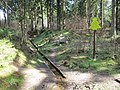
Innermost source

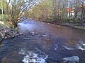
Inmost between Wildemann and Lautenthal

Former Railway bridge over the Innerste in Lautenthal

The lute flows into the innermost

The Innerste flows into the Innerste Dam at normal water levels
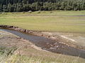
Innerste in the reservoir of the Innerste dam when the water level is low
Lot at the innermost in Langelsheim

Weir of the innermost at Salzgitter-Hohenrode

Franzosenbrücke over the Innerste near Salzgitter-Hohenrode

Innerste in the center of Hildesheim

Innerste in Hildesheim, which has been converted into a whitewater facility

Malzfeldt mill in Sarstedt

The Innerste flows into the Leine near Sarstedt-Ruthe


literature
- Sönke Martens, Erich Heinemann: Inner most lifeline: from the source to the mouth. Gerstenberg, Hildesheim 1999, ISBN 3-8067-8543-0
- Heinrich Hofmeister: Innerstetal natural area. Announcements from the Paul Feindt Foundation Volume 4. Gerstenberg, Hildesheim 2003
- Bibliographisches Institut & FA Brockhaus AG, 2001, Brockhaus multimedia 2002
- Ludger Feldmann: Hildesheim in the Ice Age - a journey through pictures . In: Manfred Boetzkes, Ingeborg Schweitzer, Jürgen Vespermann (eds.): EisZeit. The great adventure of mastering nature. Book accompanying the exhibition of the same name. Jan Thorbecke Verlag, Stuttgart 1999 and Roemer- und Pelizaeus-Museum Hildesheim 1999, pages 95-106.
- Horst Nehler: The innermost: views and history of a river landscape. Hildesheim Contributions to Cultural History Volume 3. Gerstenberg, Hildesheim 2010, ISBN 978-3-8067-8750-4
- Hans-Oiseau Kalkmann: ... the innermost one prepares the bed. in: Die Lamme, biography of a river, Gerstenberg, Hildesheim 2010, page 9. ISBN 978-3-8067-8746-7
reception
The innermost is the topos of a novella by Wilhelm Raabe , based on an etching by Eberhard Schlotter .
Web links
Individual evidence
- ^ German Hydrological Yearbook Weser-Ems 2014. Lower Saxony State Agency for Water Management, Coastal Protection and Nature Conservation, p. 201, accessed on October 4, 2017 (PDF, German, 8805 kB).
- ↑ Johann Huebner's newly expanded and improved real state, newspaper and conversation lexicon: In it both the religions and spiritual orders, the empires and states, seas, lakes ... As well as other words that appear in newspapers and everyday dealings, borrowed from foreign languages ... Described clearly and clearly. Vienna 1780, p. 1182.
- ↑ Sarstede . In: Johann Heinrich Zedler: Large complete universal lexicon of all sciences and arts. Volume 34, Leipzig 1742, column 143.
- ↑ Water quality map Innerste Quelle
- ↑ Water quality map Innerste Mitte
- ↑ Water quality map Innerste Nord
- ↑ Friedhart Knolle : Mining-induced heavy metal contamination and soil planning in the Harz region online archive today ( Memento from March 7, 2011 in the Internet Archive )
- ↑ NSG regulation Mittleres Innerstetal ( Memento from March 4, 2016 in the Internet Archive ) (PDF; 4.2 MB), accessed on June 8, 2011.
- ^ BR 131 at the NLWKN , accessed on June 8, 2011.
- ↑ NSG regulation Innersteaue (PDF; 989 kB), accessed on June 8, 2011.
- ↑ [NSG regulation Haseder Busch], accessed on June 8, 2011
- ^ Ha 53 at the NLWKN , accessed on June 8, 2011.