Kanstein (Langelsheim)
| Kanstein | ||
|---|---|---|
| height | 235 m above sea level NN | |
| location | District of Goslar , east of the city of Langelsheim | |
| Coordinates | 51 ° 56 '23 " N , 10 ° 21' 18" E | |
|
|
||
| rock | limestone | |
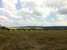
The Kanstein is a mountain east of Langelsheim north of the Harz border . Its height is 235 m above sea level. NN . Geologically, it consists essentially of limestone from the Upper Cretaceous .
Limestone is still extracted in a quarry there today . On the mountain plateau on the northern edge, which sloped steeply towards the innermost edge, was the Kansteinburg, which probably originated from the Carolingian period .
The rocky slopes of the Kanstein and areas of the Kanstein plateau are part of the Mittleres Innerstetal nature reserve with Kanstein .
Individual evidence
- ↑ Torsten Schröpfer: Treasure trove - interesting facts about the western Harz mining and metallurgy . Oberharzer Geschichts- und Museumsverein eV (Ed.), Clausthal-Zellerfeld 2000, ISBN 3-923605-08-0 .
swell
- Torsten Schröpfer: Treasure trove - interesting facts about the West Harz mining and metallurgy . Oberharzer Geschichts- und Museumsverein eV (Ed.), Clausthal-Zellerfeld 2000, ISBN 3-923605-08-0 .


