
Grumbach (Innerste)
| Grumbach | ||
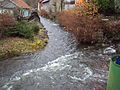
.JPG) Grumbach in the valley above Wildemann |
||
| Data | ||
| location | Lower Saxony , Germany | |
| River system | Weser | |
| Drain over | Innerste → Leine → Aller → Weser → North Sea | |
| source | Near Auerhahn (northeast of Bockswiese ) 51 ° 51 ′ 12 ″ N , 10 ° 21 ′ 48 ″ E |
|
| Source height | 640 m above sea level NN | |
| muzzle | In the urban area of Wildemann in the innermost coordinates: 51 ° 49 '43 " N , 10 ° 16' 54" E 51 ° 49 '43 " N , 10 ° 16' 54" E |
|
| Mouth height | 390 m above sea level NN | |
| Height difference | 250 m | |
| Bottom slope | 30 ‰ | |
| length | 8.4 km | |
| Catchment area | 24 km² | |
| Left tributaries | Spiegelbach | |
| Right tributaries | Kuttelbach | |
| Reservoirs flowed through | Auerhahner Teich , Neuer Grumbacher Teich, Oberer Grumbacher Teich, Middle Grumbacher Teich, Oberer Flößteich, Unterer Flößteich, (Lower) Grumbacher Teich | |
| Small towns | Wild man | |
| Communities | Rooster clover | |
| Residents in the catchment area | 2,000 | |
The Grumbach is an 8.4 km long right tributary of the Innerste in the Upper Harz , Lower Saxony , Germany .
course
The Grumbach rises at around 640 m above sea level. NN in the Upper Harz south-east of Hahnenklee near the Auerhahn near the federal road 241 . After a few hundred meters, the Grumbach is dammed together with some other nameless source streams in the Auerhahnteich , an artificial pond of the Upper Harz water shelf , which will significantly influence the Grumbach along its entire length. After the Grumbach has left the Auerhahnteich via the flood relief system or via the bottom outlet , the Neue Grumbacher Teich follows a short stretch of flow , shortly behind it the Obere Grumbacher Teich , then the Middle Grumbacher Teich , then the Obere Flößteich and finally the Lower Flößteich . All six dams are part of the Oberharzer water shelf ( Oberharzer Ponds ). Due to the cascading arrangement of the ponds, this approximately 2 kilometer long stretch of river is also called the capercaillie cascade . The direction of flow of the Grumbach swings in this course from southwest to west.
Below the Lower Flößteich, the Grumbach initially flows through a meadow. It is located here in the local area of Bockswiese , a district of Goslar . Here the Grumbach has to cross a dump from the historic Upper Harz mining industry . When this dump was filled up in the 18th and 19th centuries, a tunnel made of dry stone vaults was left for the Grumbach . Below, west of Bockswiese, the Grumbach initially flows naturally through a forest area. The Kuttelbach flows in from the right . Shortly after the confluence with the Kuttelbach, the Grumbach is diverted into the Grumbacher Graben , a slope ditch of the Upper Harz water shelf that is parallel to the contour lines (cf. Oberharzer Graben ). Today, the main purpose of this ditch is to lead the Grumbach past the Grumbacher Teich , which however, due to the capacity of the ditch, only succeeds completely with low drainage. At higher drains, excess water flows over the misses towards the Grumbacher pond.
At today's end of the active Grumbacher Graben, just below (= west) of the Grumbacher pond, the Grumbach falls over almost 20 meters in an impressive waterfall into the Grumbach valley. Here it also flows together with the drainage of the Grumbacher pond, which essentially still carries water from the Dreckstalbach . On the following stretch of the river, about 2 kilometers long, the Grumbach runs largely close to nature through a diverse forest area, the direction of flow here swings towards the south. At the entrance to Wildemann , the Grumbach swings again to the right towards the west, at the same time it receives a tributary from the left with the Spiegelbach , the size of which can be compared with the Grumbach. In the following one kilometer long course through the urban area of Wildemann, the river is called Grumbach by the Wildemannern; the valley through which it flows is called Spiegelthal, just like the parallel street .
The Grumbach flows into the innermost part of the town center of Wildemann.
Water management and geology
The Grumbach has already been massively changed a few hundred meters below the source due to mining and settlement activities. Migration movements of z. B. Brown trout are thus largely restricted. The water of the Grumbach is very poor in nutrients and of high quality due to the low settlement influences. There are definitely brown trout populations in the Grumbacher Graben and in the approximately 3 kilometer-long course between the Grumbacher pond and the confluence in the Innerste.
The geology of the catchment area is characterized by the typical resin alternation of slate and greywacke .
Web links
- NLWKN Water Quality Report 2000 (PDF; 8.33 MB, accessed on October 14, 2012) Unfortunately, this water quality report contains some errors about the course and the mouth of the Grumbach (page 47).
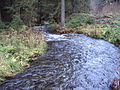
Grumbach at the confluence with the Innerste. The discharge on the day of admission corresponds to 3 times the mean discharge.
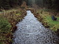
Grumbach above Wildemann
Grumbach above Wildemann
.JPG)
.JPG)
.JPG)