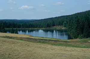
Capercaillie pond
| Capercaillie pond | |||||||||
|---|---|---|---|---|---|---|---|---|---|
| The Auerhahn pond seen from the former Auerhahn Inn | |||||||||
|
|||||||||
|
|
|||||||||
| Coordinates | 51 ° 51 '8 " N , 10 ° 21' 40" E | ||||||||
| Data on the structure | |||||||||
| Lock type: | dam | ||||||||
| Construction time: | 1684 | ||||||||
| Height above valley floor: | 7.74 m | ||||||||
| Crown length: | 170 m | ||||||||
| Operator: | Harz waterworks | ||||||||
| Data on the reservoir | |||||||||
| Altitude (at congestion destination ) | 610.56 | ||||||||
| Water surface | 1.2 ha | ||||||||
| Total storage space : | 61 000 m³ | ||||||||
| Catchment area | 0.36 km² | ||||||||
| Design flood : | 1.18 m³ / s | ||||||||
The Auerhahnteich (also Auerhahner Teich) in the Harz is an artificial pond created in 1684 near Clausthal-Zellerfeld in the Goslar district in Lower Saxony . It belongs to the Upper Harz ponds and served to supply the mines on the Bockswieser Gangzug with impact water . The impact water was first fed to the Herzog-Anton-Ulrich-Schacht through the 1150 m long Auerhahner Graben . The Auerhahnteich, in turn, was supplied with water by the Schalke through the 1440 m long, now disused Bärenthaler Graben .
The reservoir is located in the Upper Harz in the Harz Nature Park . It is located around 8 km north of Clausthal-Zellerfeld , already in the area of the city of Goslar, which is around 11 km away . The capercaillie pond is the topmost of the six ponds of the capercaillie cascade on the Grumbach . The Hahnenklee district of Goslar gets its drinking water from the Auerhahnteich, among other places. The Auerhahnteich is part of the Upper Harz water shelf and therefore also part of the Rammelsberg World Heritage Site , the old town of Goslar and the Upper Harz Water Management .
The name of the pond comes from the nearby saddle with a small property called Auerhahn . A former Weghaus is also located here, which was run as the Auerhahn mountain inn until the early 2000s. There is also a private holiday home and a former forester's house.
literature
- Martin Schmidt : The water management of the Upper Harz mining industry . In: Series of publications by the Frontinus Society. V . 3rd, supplemented edition. Issue 13. Harzwasserwerke, Hildesheim 2002, ISBN 3-00-009609-4 .
- Walter Knissel , Gerhard Fleisch: cultural monument "Upper Harz water shelf" . An epoch-making achievement. 2nd Edition. Paper plane, Clausthal-Zellerfeld 2005, ISBN 3-89720-725-7 .
- Mathias Döring, Justus Teicke: Upper Harz Water Management raised to a World Heritage Site (= publications of the German Water History Society . No. 14 ). 2010, ISBN 978-3-8391-8665-7 , pp. 133-149 .
- Justus Teicke: UNESCO World Heritage Upper Harz Water Management - The Upper Harz Water Shelf, the most important pre-industrial energy generation and supply system in the world . Harzwasserwerke, Clausthal-Zellerfeld 2011 (24 p., Harzwasserwerke.de [PDF; 27.8 MB ]).
- Martin Schmidt: WasserWanderWege, a guide through the Upper Harz water shelf - world cultural heritage . Ed .: Harzwasserwerke GmbH. 4th edition. Papierflieger Verlag, Clausthal-Zellerfeld 2012, ISBN 978-3-86948-200-2 .
- Harz Nature Park (West Harz), topographic map 1:50 000 with hiking trails . Lower Saxony Land Surveying Office - Land Survey, 1981 edition
See also
Web links
- www.anglermap.de: Water profile for the Auerhahner pond
- The grouse pond. In: harzlife.de. Retrieved November 7, 2014 .


